RKPS — Sacheon
RKPS AD 2.1 AERODROME LOCATION INDICATOR AND NAME
RKPS - SACHEON / Domestic
RKPS AD 2.2 AERODROME GEOGRAPHICAL AND ADMINISTRATIVE DATA
|
1 |
ARP coordinates and site at AD |
350519N 1280414E 39° / 1 299 m from THR 06R | |
|
2 |
Direction and distance from city |
329°, 9.5 km from Sacheon City Hall | |
|
3 |
Elevation/Reference temperature |
8 m / 31 ˚C | |
|
4 |
Geoid undulation at AD ELEV PSN |
28 m | |
|
5 |
MAG VAR/Annual change |
8° W(2020) / 0.089˚ Increasing | |
|
6 |
Aerodrome Operator, Address, Telephone, Telefax, AFS |
MOLIT |
Sacheon Airport Branch(Busan Regional Office of Aviation) 1971, Sacheon-daero, Sacheon-eup, Sacheon-si, Gyeongsangnam-do 664-801, Republic of Korea Tel : +82-55-852-2568 Telefax : +82-55-852-6580 AFS : RKPSZPZX |
|
ROKAF |
Republic Of Korea Air Force(ROKAF) The 3rd Flying training Wing | ||
|
7 |
Types of traffic permitted(IFR/VFR) |
IFR/VFR | |
|
8 |
Remark |
NIL | |
RKPS AD 2.3 OPERATIONAL HOURS
|
1 |
Aerodrome Operator |
2200-1300 UTC* |
|
2 |
Customs and Immigration |
NIL |
|
3 |
Health and Sanitation |
NIL |
|
4 |
AIS Briefing Office |
2230-1030 UTC |
|
5 |
ATS Reporting Office |
HO |
|
6 |
MET Briefing Office |
H24 |
|
7 |
ATS |
H24 |
|
8 |
Fuelling |
HO |
|
9 |
Handling |
HO |
|
10 |
Security |
HO |
|
11 |
De-icing |
NIL |
|
12 |
Remarks |
* Outside these hours services are available under the Pre-coordination (passenger flights only) |
RKPS AD 2.4 HANDLING SERVICES AND FACILITIES
|
1 |
Cargo-handling facilities |
NIL |
|
2 |
Fuel/oil types |
JP-8/O-128, O-133(Available by agreement with ROKAF) |
|
3 |
Fuelling facilities/capacity |
NIL |
|
4 |
De-icing facilities |
One de-icing pad(Aircraft stand NR. 1) |
|
5 |
Hangar space for visiting aircraft |
NIL |
|
6 |
Repair facilities for visiting aircraft |
NIL |
|
7 |
Remarks |
NIL |
RKPS AD 2.5 PASSENGER FACILITIES
|
1 |
Hotels |
Near AD and in Sacheon city |
|
2 |
Restaurants |
At AD(60 seats, light food service available) and in the city |
|
3 |
Transportation |
Buses, taxis, rental and cars from the AD |
|
4 |
Medical Facilities |
Hospitals in Sacheon city, 4 km |
|
5 |
Bank and Post Office |
Near AD and in Sacheon city |
|
6 |
Tourist Office |
Available at AD |
|
7 |
Remarks |
https://www.airport.co.kr/sacheon/ |
RKPS AD 2.6 RESCUE AND FIRE FIGHTING SERVICES
|
1 |
AD Category for fire fighting |
Category 7 |
|
2 |
Rescue equipment |
|
|
3 |
Capability for removal of disabled aircraft |
Specialized aircraft recovery equipment available for up to and including B737 size aircraft. 300 ton crane and other accessory equipment can be provided by airlines and agencies. Korea Airports Corporation is the co-ordinator for the removal of disabled aircraft and can be reached at Airport Duty Manager. (Tel : +82-55-831-9331~9332) |
|
4 |
Remarks |
* Aqueous Film Forming Foam |
RKPS AD 2.7 SEASONAL AVAILABILITY - CLEARING
|
1 |
Type of clearing equipment |
a. ROKAF :
b. KAC
|
|
2 |
Clearance priorities |
|
|
3 |
Remarks |
Snow clearance information promulgated by SNOWTAM |
RKPS AD 2.8 APRONS, TAXIWAYS AND CHECK LOCATIONS/POSITIONS DATA
|
1 |
Designation, Apron surface and strength |
|
|
2 |
Designation, Taxiway width, surface and strength |
|
|
3 |
Altimeter check location and elevation |
Aprons / 27 ft |
|
4 |
VOR/INS check points |
VOR : NIL INS : Every specified aircraft stands(Refer to Aircraft Parking / Docking Chart) |
|
5 |
Remarks |
NIL |
RKPS AD 2.9 SURFACE MOVEMENT GUIDANCE AND CONTROL SYSTEM AND MARKINGS
|
1 |
Use of aircraft stand ID signs, TWY guidelines and visual docking/parking guidance system of aircraft stands |
|
|
2 |
RWY and TWY markings and LGT |
|
|
3 |
Stop bars |
NIL |
|
4 |
Remarks |
NIL |
RKPS AD 2.10 AERODROME OBSTACLES
|
In Area 2 | |||||
|
OBST ID/ Designation |
OBST type |
OBST position |
ELEV/HGT |
Markings/ Type, colour |
Remarks |
|
a |
b |
c |
d |
e |
f |
|
RKPSOB001 |
Mountain |
350423.3N 1280221.1E |
244 ft/ |
NIL |
06L/R APCH 24L/R TKOF |
|
RKPSOB002 |
Mountain |
350328.9N 1280019.8E |
393 ft/ |
NIL | |
|
RKPSOB003 |
Mountain |
350114.2N 1275803.7E |
419 ft/ |
NIL | |
|
RKPSOB004 |
Mountain |
345934.2N 1275211.1E |
3 011 ft/ (Including Steel tower 243 ft) |
NIL | |
|
RKPSOB005 |
Mountain |
350423.2N 1280220.8E |
244 ft/ |
NIL | |
|
RKPSOB006 |
Mountain |
345851.0N 1280556.6E |
2 630 ft/ |
NIL | |
|
RKPSOB007 |
Mountain |
350447.1N 1280237.9E |
213 ft/ |
NIL | |
|
RKPSOB008 |
Mountain |
350640.5N 1280404.5E |
419 ft/ |
NIL |
In 06L/R, 24L/R circling area and at AD |
|
RKPSOB009 |
Mountain |
350627.6N 1280302.7E |
499 ft/ |
NIL | |
|
RKPSOB010 |
Mountain |
350810.6N 1280349.5E |
607 ft/ |
NIL | |
|
RKPSOB011 |
Mountain |
350652.2N 1280015.2E |
617 ft/ |
NIL | |
|
RKPSOB012 |
Mountain |
350514.2N 1275803.1E |
735 ft/ |
NIL | |
|
RKPSOB013 |
Hill |
350602.3N 1280521.1E |
84 ft/ |
NIL |
06L/R TKOF 24L/R APCH |
|
RKPSOB014 |
Mountain |
350607.5N 1280607.4E |
224 ft/ |
NIL | |
|
RKPSOB015 |
Mountain |
350606.2N 1280626.3E |
281 ft/ |
NIL | |
|
RKPSOB016 |
Mountain |
350638.6N 1280914.3E |
906 ft/ |
NIL | |
|
In Area 3 | |||||
|
OBST ID/ Designation |
OBST type |
OBST position |
ELEV/HGT |
Markings/ Type, colour |
Remarks |
|
a |
b |
c |
d |
e |
f |
|
NIL | |||||
| |||||
RKPS AD 2.11 METEOROLOGICAL INFORMATION PROVIDED
|
1 |
Associated MET Office |
Sacheon Airforce MET Office |
|
2 |
Hours of service MET Office outside hours |
24 hours - |
|
3 |
Office responsible for TAF preparation Periods of validity |
ROKAF MET Office 30 hours at 0000, 0600, 1200, 1800 UTC |
|
4 |
Trend forecast Interval of issuance |
NIL |
|
5 |
Briefing/consultation provided |
Available at Aviation Meteorological Office for 24 hours, if required |
|
6 |
Flight documentation Language(s) used |
Aerodrome forecasts(TAF code form), SIGWX charts, WINTEM charts, SIGMET information in English |
|
7 |
Charts and other information available for briefing or consultation |
Analysis charts(surface and upper air), Prognostic charts, Graphic displays and other model outputs |
|
8 |
Supplementary equipment available for providing information |
Satellite and weather radar imageries |
|
9 |
ATS units provided with information |
FIC and TWR |
|
10 |
Additional information (limitation of service etc.) |
All observation data, model outputs and forecasts produced by KMA and WAFS are available at the office through Internet link. |
RKPS AD 2.12 RUNWAY PHYSICAL CHARACTERISTICS
|
Designations Runway NR |
TRUE BRG |
Dimension of RWY(m) |
Strength(PCN) and surface of RWY and SWY |
THR coordinates RWY end coordinates THR geoid undulation |
THR elevation and highest elevation of TDZ of precision APP RWY | ||||||||||||||||||||||||||||||||||||||||
|---|---|---|---|---|---|---|---|---|---|---|---|---|---|---|---|---|---|---|---|---|---|---|---|---|---|---|---|---|---|---|---|---|---|---|---|---|---|---|---|---|---|---|---|---|---|
|
1 |
2 |
3 |
4 |
5 |
6 | ||||||||||||||||||||||||||||||||||||||||
|
06R |
055.59° |
2 743 × 46 m |
PCN 62/R/B/W/T Concrete |
350452.63N 1280334.87E - |
THR 16 ft / 5 m | ||||||||||||||||||||||||||||||||||||||||
|
24L |
235.60° |
2 743 × 46 m |
PCN 62/R/B/W/T Concrete |
350542.93N 1280504.22E - |
THR 24 ft / 7 m | ||||||||||||||||||||||||||||||||||||||||
|
06L |
055.58° |
2 743 × 46 m |
PCN 70/R/C/X/T Asphart |
350455.95N 1280324.81E - |
THR 15 ft / 5 m | ||||||||||||||||||||||||||||||||||||||||
|
24R |
235.59° |
2 743 × 46 m |
PCN 70/R/C/X/T Asphart |
350546.26N 1280454.16E - |
THR 19.3 ft / 5.9 m TDZ 19.3 ft / 5.9 m | ||||||||||||||||||||||||||||||||||||||||
|
7. Slope of RWY-SWY | |||||||||||||||||||||||||||||||||||||||||||||
 | |||||||||||||||||||||||||||||||||||||||||||||
RKPS AD 2.13 DECLARED DISTANCES
|
RWY Designator |
TORA (m) |
TODA (m) |
ASDA (m) |
LDA (m) |
Remarks |
|---|---|---|---|---|---|
|
1 |
2 |
3 |
4 |
5 |
6 |
|
06R |
2 743 |
3 043 |
2 743 |
2 743 |
NIL |
|
24L |
2 743 |
3 043 |
2 743 |
2 743 |
NIL |
|
06L |
2 743 |
3 043 |
2 743 |
2 743 |
NIL |
|
24R |
2 743 |
2 928 |
2 743 |
2 743 |
NIL |
RKPS AD 2.14 APPROACH AND RUNWAY LIGHTING
|
RWY Designator |
APCH LGT type LEN INTST |
THR LGT Color WBAR |
VASIS (MEHT) PAPI |
TDZ LGT LEN |
RWY Center Line LGT Length, Spacing Color, INTST |
RWY edge LGT LEN, Spacing Color INTST |
RWY End LGT Color WBAR |
SWY LGT LEN(M) Color |
Remarks |
|---|---|---|---|---|---|---|---|---|---|
|
1 |
2 |
3 |
4 |
5 |
6 |
7 |
8 |
9 |
10 |
|
06R |
ALSF-I 762 m LIH |
Green |
PAPI Both/3° (53 ft) |
NIL |
NIL |
2 749 m 60 m WHITE LIH |
RED |
NIL |
NIL |
|
24L |
SSALS 304 m |
Green |
PAPI Both/3° (51 ft) |
NIL |
NIL |
2 749 m 60 m WHITE LIH |
RED |
NIL | |
|
06L |
ALSF-I 762 m LIH |
Green |
PAPI Both/3.7° (60 ft) |
NIL |
NIL |
2 749 m 60 m WHITE LIH |
RED |
NIL | |
|
24R |
NIL |
Green |
PAPI Both/3.2° (56 ft) |
NIL |
NIL |
2 749 m 60 m WHITE |
RED |
NIL |
RKPS AD 2.15 OTHER LIGHTING, SECONDARY POWER SUPPLY
|
1 |
ABN/IBN location, characteristics and hours of operation |
ABN : At ATC Tower, FLG W/W-G (16 ~ 20 FPM*) / IBN : NIL Hours of Operation : H24 (ROKAF) * FPM : Flash Per Minute |
|
2 |
LDI location and LGT Anemometer location and LGT |
NIL |
|
3 |
TWY edge and center line lighting |
Edge : All TWY Center line : NIL |
|
4 |
Secondary power supply/switch-over time |
Secondary power supply to all lighting at AD Switch-over time : 7-8 SEC |
|
5 |
Remarks |
NIL |
RKPS AD 2.16 HELICOPTER LANDING AREA
|
1 |
Coordinates TLOF or THR of FATO Geoid undulation |
- |
|
2 |
TLOF and/or FATO elevation(m/ft) |
- |
|
3 |
TLOF and FATO area dimensions, surface, strength, marking |
- |
|
4 |
True BRG of FATO |
- |
|
5 |
Declared distance available |
- |
|
6 |
APP and FATO lighting |
- |
|
7 |
Remarks |
As directed by ATC. |
RKPS AD 2.17 ATS AIRSPACE
|
1 |
Designation and lateral limit |
Sacheon CTR A circle, 5 NM radius centered at ARP |
|
2 |
Vertical limits |
SFC to 4 000 ft AGL |
|
3 |
Airspace classification |
C |
|
4 |
ATS unit call sign Language(s) |
Sacheon Tower English / Korean |
|
5 |
Transition altitude |
14 000 ft AMSL |
|
6 |
Operation hours |
H24 |
|
7 |
Remarks |
NIL |
RKPS AD 2.18 ATS COMMUNICATION FACILITIES
|
Service designation |
Call sign |
Channel |
Hours of operation |
Remarks |
|---|---|---|---|---|
|
1 |
2 |
3 |
4 |
5 |
|
APP |
Sacheon APP |
135.4 MHz 344.7 MHz |
H24 |
NIL |
|
DEP |
Sacheon DEP |
135.4 MHz 347.3 MHz |
H24 |
NIL |
|
ARR |
Sacheon ARR |
134.1 MHz 134.4 MHz 237.9 MHz 244.9 MHz 339.7 MHz 384.0 MHz |
H24 |
- Do not contact initial. - Caution : 134.1/134.4 MHz is jammed by the adjacent airports |
|
TWR |
Sacheon Tower |
126.2 MHz 236.6 MHz 305.4 MHz |
H24 |
UNREL COM : RDL 080-150 beyond 15 NM BLW 6 500 ft, due to terrain. |
|
GND DLVRY |
Sacheon Ground |
126.2 MHz 275.8 MHz |
H24 |
NIL |
|
ATIS |
Sacheon Airport |
126.225 MHz 225.475 MHz |
2100-1200 |
NIL |
|
VFR RADAR Advisery Service |
Sacheon Service |
135.4 MHz 230.8 MHz |
H24 |
Rader is required the service |
|
EMERGENCY |
121.5 MHz 243.0 MHz |
H24 |
NIL |
RKPS AD 2.19 RADIO NAVIGATION AND LANDING AIDS
|
Type of aid, null |
ID |
Frequency |
Hours of operation |
Position of transmitting antenna coordinates |
Elevation of DME transmitting antenna |
Remarks |
|---|---|---|---|---|---|---|
|
1 |
2 |
3 |
4 |
5 |
6 |
7 |
|
LOC 06L (8° W/2020) |
ISAM |
109.1 MHz |
H24 |
350550.6N 1280502.0E |
- |
NIL |
|
DME 06L |
ISAM |
989 MHz (CH 28X) |
H24 |
350550.2N 1280504.8E |
0 m |
NIL |
|
LOC 24R (8° W/2020) ILS CAT I (8° W or 352°) |
ISHA |
108.1 MHz |
H24 |
350452.6N 1280318.8E |
- |
NIL |
|
DME 24R |
979 MHz (CH 18X) |
H24 |
350544.2N 1280441.9E |
0 m |
NIL | |
|
GP 24R |
334.7 MHz |
H24 |
350544.2N 1280441.8E |
0 m |
3.2° ILS | |
|
VOR/DME (8° W/2020) |
SAC |
115.1 MHz (CH 98X) |
H24 |
350551.9N 1280434.7E | 0 m |
DME unusable RDL 310-040 beyond 18 NM BLW 10 000 ft RDL 110-180 beyond 17 NM BLW 6 000 ft |
|
Scheduled Inspection time - All radio navigation and landing aids : Every 3rd THU(1500-2000 UTC) of the month. | ||||||
RKPS AD 2.20 LOCAL AERODROME REGULATIONS
-
Between Jet aircraft that type of aircraft differ each : 500 ft
-
Between Heavy/Large aircraft or Jet aircraft behind conventional aircraft : 2 000 ft
It is an area at either side 5 NM of R 190 SAC between 27 DME and 32 DME.
-
A call sign and a type of aircraft
-
A reason of dumping
-
Other
RKPS AD 2.21 NOISE ABATEMENT PROCEDURES
|
NIL |
RKPS AD 2.22 FLIGHT PROCEDURES
-
Circling not authorized in South East of Airport.
-
Circling Area radius for ROC(required obstacle clearance) as follows.
|
Approach Category |
Radius from threshold |
|
A |
1.3 NM |
|
B |
1.81 NM |
|
C |
2.84 NM |
|
D |
3.70 NM |
|
E |
4.63 NM |
Apply the published take-off weather minima of the Standard Instrument Approach used.
-
Standard Instrument Departure(SID) procedures are designed by U.S TREPS (CHG 25).
-
All aircraft - When departing using RWY 24L/R, maintain 35 ft AGL or above over DER.
-
Instrument Approach procedures are designed by U.S TERPS (CHG 25).
-
When Sacheon Radar is unserviceable, CAT "E" Aircraft can use ONLY HI-TACAN-A Approach.
-
RWY 06R
-
Weather minima
CAT
GS / TCH(ft) / RPI(ft)
DA(ft) / VIS(SM)
HAT(ft)
Ceiling(ft)
A, B, C, D
A, B, C, D, E
FULL
3.0° / 51 / 958.24
219 / RVR 3 000 ft VIS 5/8
200
200
ALS INOP
3.0° / 51 / 958.24
219 / RVR 4 000 ft VIS 3/4
200
200
-
Missed Approach Procedure : Climb to 4 400 ft via HDG 064° and as directed by ATC.
Knots
60
120
180
240
300
TO
Rate of Climb
V/V(fpm)
280
560
840
1 120
1 400
4 400
-
Caution 3 011 ft obstacle(Mt. Geumo) close to the initial segment. Initial segment, ASR 11 NM-(IF), does not meet standard required obstacle clearance 1 000 ft. Mt. Geumo located R 247 SAC/12 DME. Therefore maintain at or above 3 600 ft until crossing 11 DME from SAC.
-
-
RWY 24L
-
Weather minima
-
Missed Approach Procedure : Climb to 4 500 ft via HDG 244° to 1 600 ft, then turn left HDG 220° and as directed by ATC.
Knots
60
120
180
240
300
TO
Rate of Climb
V/V(fpm)
280
560
840
1 120
1 400
3 900
CAT
GS / TCH(ft) / RPI(ft)
DA(ft) / VIS(SM)
HAT(ft)
Ceiling(ft)
A, B, C, D
A, B, C, D, E
FULL
3.0° / 50 / 970.52
527 / 1¾
503
600
ALS INOP
3.0° / 50 / 970.52
527 / 1¾
503
600
-
-
RWY 06R
-
Weather minima
-
Missed Approach Procedure : Climb to 4 400 ft via HDG 064° and as directed by ATC.
-
Caution 3 011 ft obstacle(Mt. Geumo) close to the initial segment. Initial segment, ASR 11 NM-(IF), does not meet standard required obstacle clearance 1 000 ft. Mt. Geumo located R 247 SAC/12 DME. Therefore maintain at or above 3 600 ft until crossing 11 DME from SAC.
CAT
A
B
C
D
E
Straight-in
FULL
820/45
801(800-⅞)
820-1⅞
801(800-1⅞)
ALS INOP
820/55
801(800-1)
820/60
801(800-1¼)
820-2½
801(800-2½)
Circling
820-1
795(800-1)
900/1¼
875(900-1¼)
1 000-3
975(1 000-3)
1 120-3
1 095(1 100-3)
Knots
60
120
180
240
300
TO
Rate of Climb
V/V(fpm)
240
480
720
960
1 200
4 400
-
-
RWY 24L
-
Weather minima
CAT
A
B
C
D
E
Straight-in
FULL
1 240/55
1 216(1 300-1)
1 240/60
1 216(1 300-1¼)
1 240-3
1 216(1 300-3)
ALS INOP
1 240/60
1 216(1 300-1¼)
1 240-1½
1 216(1 300-1½)
1 240-3
1 216(1 300-3)
Circling
1 240-1¼
1 215(1 300-1¼)
1 240-1½
1 215(1 300-1½)
1 240-3
1 215(1 300-3)
-
Missed Approach Procedure : Climb to 4 500 ft via HDG 244° to 1 600 ft, then turn left HDG 220° and as directed by ATC.
Knots
60
120
180
240
300
TO
Rate of Climb
V/V(fpm)
220
430
640
850
1 060
4 000
-
-
RWY 06L
-
Weather minima
-
Missed Approach Procedure : Climb to 4 400 ft via HDG 064° and as directed by ATC.
-
Caution 3 011 ft obstacle(Mt. Geumo) close to the initial segment. Initial segment, ASR 11 NM-(IF), does not meet standard required obstacle clearance 1 000 ft. Mt. Geumo located R 247 SAC/12 DME. Therefore maintain at or above 3 600 ft until crossing 11 DME from SAC.
CAT
A
B
C
D
E
Straight-in
FULL
780/40
763(800-¾)
780-1¾
763(800-1¾)
ALS INOP
780/55
763(800-1)
780/60
763(800-1¼)
780-2½
763(800-2½)
Circling
800-1
775(800-1)
900/1¼
875(900-1¼)
1 000-3
975(1 000-3)
1 120-3
1 095(1 100-3)
-
-
RWY 24R
-
Weather minima
-
Missed Approach Procedure : Climb to 4 500 ft via HDG 244° to 1 600 ft, then turn left HDG 220° and as directed by ATC.
Knots
60
120
180
240
300
TO
Rate of Climb
V/V(fpm)
220
440
650
870
1 080
4 000
CAT
A
B
C
D
E
Straight-in
FULL
1 220/60
1 201(1 200-1¼)
1 220/1½
1 201(1 200-1½)
1 220-3
1 201(1 200-3)
ALS INOP
1 220/60
1 201(1 200-1¼)
1 220/1½
1 201(1 200-1½)
1 220-3
1 201(1 200-3)
Circling
1 220/1¼
1 195(1 200-1¼)
1 220/1½
1 195(1 200-1½)
1 220-3
1 195(1 200-3)
-
2 VFR Procedure
-
Ground visibility : Not less than 3 SM
-
Flight visibility : Not less than 5 SM
-
Ceiling : At or above 1 600 ft (Jet : 2 100 ft)
-
Helicopter : 500 ft
-
Conventional : 1 100 ft
-
Jet : 1 600 ft
-
VFR aircraft shall maintain two way radio communication and contact with Sacheon Approach out of 15 NM.
-
All VFR Flight within Sacheon TMA shall set transponder at 12 plus the last two digits of the call sign.
-
Pilot who has insight runway or airport, follow the instruction of Sacheon Tower.
-
Helicopter VFR Flight procedure for Arrival is as follows.
-
Get a permission to enter class C airspace from Tower prior to 15 NM.
-
When VFR Routes enter through North, Maintain at or below 1 000 ft over JIN-YANG HO(A lake), then enter a VFR Traffic Pattern via reporting points ('A' or 'B' point, at or below 500 ft).
-
When VFR Routes enter through South, Maintain at or below 500 ft, then enter the control zone via reporting points ('C' or 'D' point, at or below 500 ft).
-
-
Helicopter VFR Flight procedure for Departure is as follows.
-
Take-off RWY 06
-
When a aircraft bound to the South, Maintain at or below 300 ft to Duryang-Reservoir and turn right at outer Duryang-Reservoir, then fly at or below 500 ft within 5 NM radius of Sacheon airport.
-
When a aircraft bound to the North, turn left at the end of RWY and maintain at or below 500 ft to JIN-YANG HO(A lake).
-
-
Take-off RWY 24
-
When a aircraft bound to the South, Maintain at or below 300 ft to Gonyang Bridge and turn left, then fly at or below 500 ft within 5 NM radius of Sacheon airport.
-
When a aircraft bound to the North, turn right at the end of RWY, then direct to the destination and maintain at or below 500 ft within 5 NM radius of Sacheon airport.
-
-
-
All aircraft passing Sacheon TMA in VFR shall contact with Sacheon Approach prior to 15 NM, and Fly 10 NM outside of Sacheon airport.
3 RADIO COMMUNICATION FAILURE PROCEDURE
-
General
- No person may take off unless two-way radio communications can be maintained with the Air Traffic Control.
- On recognition of communication failure during flight, squawk 7600 and if necessary to ensure safe altitude, climb to Minimum Safe Altitude or above to maintain obstacle clearance. Then comply with following procedures.
-
VMC
If the failure occurs in VFR conditions, or if VFR condition are encountered after the failure, each pilot shall continue the flight under VFR and land as soon as practicable (based on the runway in use).
-
IMC
If the failure occurs in IFR conditions, or if paragraph 2 of this section cannot be complied with, each pilot shall continue the flight according to the following :
-
DEPARTURE
-
Under Pilot Navigation
- Runway 06R/06L in use
1) SACHEON 1
Climb HDG 064° to SAC D5 thence,.......
................Climb to 8 000 ft via the following transition routes.
-
ANUBA TRANSITION : Left turn HDG 310° to cross R 020 SAC and left turn HDG 240° to R 283 SAC and R 283 SAC to ANUBA.
-
SAPDI TRANSITION : Right turn HDG 130° to intercept R 093 SAC and R 093 SAC to SAPDI.
-
TOPAX TRANSITION : Right turn HDG 190° to intercept R 142 SAC and R 142 SAC to TOPAX.
-
GOSBO TRANSITION : Right turn HDG 250° to intercept R 204 SAC and R 204 SAC to GOSBO.
-
ENGOT TRANSITION : Right turn HDG 190º to intercept R 138 SAC and R 138 SAC to ENGOT.
-
POVOR TRANSITION : Right turn HDG 250º to intercept R 207 SAC and R 207 SAC to POVOR.
2) VONDU 1(RNAV)
Take-off RWY 06L : Climb course 064° to VONDU thence,.......
Take-off RWY 06R : Climb course 063° to VONDU thence,.......
................Climb to 8 000 ft via the following transition routes.
-
ANUBA TRANSITION : From VONDU on track 334º to PS061 and track 258º to PS062 and track 258º to ANUBA.
-
MASTA TRANSITION : From VONDU on track 052º to MASTA.
-
SARAM TRANSITION : From VONDU on track 102º to SARAM.
-
GOSBO TRANSITION : From VONDU on track 153º to BOTRU and track 209º to PS151 and track 218º to PS152 and track 218º to GOSBO.
-
POVOR TRANSITION : From VONDU on track 153º to BOTRU and track 209º to PS151 and track 218º to PS152 and track 224º to POVOR.
- Runway 24L/24R in use
3) SACHEON 2
Climb HDG 244° to SAC D5 thence,.......
................ Climb to 8 000 ft via the following transition routes.
-
ANUBA TRANSITION : Right turn HDG 330° to intercept R 283 SAC and R 283 SAC to ANUBA.
-
GOSBO TRANSITION : Left turn HDG 150° to intercept R 204 SAC and R 204 SAC to GOSBO.
-
TOPAX TRANSITION : Left turn HDG 050° to intercept R 142 SAC and R 142 SAC to TOPAX.
-
SAPDI TRANSITION : Left turn HDG 050° to intercept R 093 SAC and R 093 SAC to SAPDI.
-
ENGOT TRANSITION : Left turn HDG 050º to intercept R 138 SAC and R 138 SAC to ENGOT.
-
POVOR TRANSITION : Left turn HDG 150º to intercept R 207 SAC and R 207 SAC to POVOR.
4) AKLOG 1(RNAV)
Take-off RWY 24L : Climb course 244° to AKLOG thence,.......
Take-off RWY 24R : Climb course 243° to AKLOG thence,.......
................Climb to 8 000 ft via the following transition routes.
-
ANUBA TRANSITION : From AKLOG on track 333° to PS241 and track 274º to ANUBA.
-
MASTA 1 TRANSITION : From AKLOG on track 333º to PS241 and track 055º to PS242 at or above 8 000 ft, then track 070º to MASTA.
-
MASTA 2 TRANSITION : From AKLOG on track 154° to PS243 at or above 6 000 ft, then track 064º to BOTRU and track 037º to PS244 and track 037º to MASTA.
-
SARAM TRANSITION : From AKLOG on track 154º to PS243 at or above 6 000 ft, then track 064º to BOTRU and track 074º to SARAM.
-
GOSBO TRANSITION : From AKLOG on track 154º to PS243 at or above 6 000 ft, then track 171º to PS151 and track 218º to PS152 and track 218º to GOSBO.
-
POVOR TRANSITION : From AKLOG on track 154º to PS243 at or above 6 000 ft, then track 171º to PS151 and track 218º to PS152 and track 224º to POVOR
5) Proceed by the direct route from the point of radio failure to the fix, route, or airway specified in the vector clearance;
6) In the absence of an assigned route, proceed by the route that ATC will advise through the forthcoming clearance; or
7) In the absence of an assigned route or a route that ATC will advise through the forthcoming clearance, proceed by the route filed in the flight plan; and
8) Maintain minimum enroute altitude(MEA) or the altitude/flight level cleared in the last ATC clearance received, whichever is higher, for 20 minutes; then
9) Continue the flight with altitude/flight level filed in the flight plan.
-
-
-
ARRIVAL
-
RWY 06 in use
1) in VMC
- The aircraft shall maintain VFR and make approach to land on RWY 06L/R.
2) in IMC
- The aircraft shall proceed to SOLYI IAF and execute (LOC/DME RWY 06L, VOR/DME RWY 06L, VOR/DME RWY 06R) APP.
-
RWY 24 in use
1) in VMC
- The aircraft shall maintain VFR and make approach to land on RWY 24L/R.
2) in IMC
- The aircraft shall proceed to KABVO IAF and execute (ILS RWY 24R, LOC/DME RWY 24R, VOR/DME RWY 24R, VOR/DME RWY 24L) APP.
* If able civil aircraft is to use RWY 06L/24R.
-
-
VFR flight which has experienced radio communication failure
-
Squawk Mode 3/A code 7600, and
-
When able to see light gun signal of control tower, follow that instruction.
-
If unable to see light gun signal of control tower, hold on downwind until ETA or for 10 minutes, whichever is later, then,
-
Aircraft on north pattern should land on RWY in use.
-
Pilot shall use caution traffic landing and departing traffic.
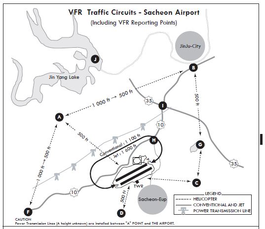
|
Reporting Point |
Geographical Name |
Position |
Coordinates(WGS-84) |
|
A |
Na Dong-Cemetery Park |
3.6 NM NW of Sacheon R 296 SAC/3.6 NM |
350702.21N 1280024.63E |
|
B |
Jin Ju I.C |
4.9 NM NE of Sacheon R 036 SAC/4.2 NM |
350937.85N 1280701.96E |
|
C |
Gu Am-Bridge |
1.5 NM E of Sacheon R 120 SAC/1.4 NM |
350521.29N 1280604.98E |
|
D |
Cho Jeon-Intersection |
2.0 NM SW of Sacheon R 197 SAC/2.6 NM |
350316.38N 1280412.64E |
|
F |
Gon Yang-Bridge |
5.3 NM W of Sacheon R 252 SAC/5.8 NM |
350328.48N 1285811.02E |
|
G |
Du Ryang-Reservoir |
3.3 NM NE of Sacheon R 075 SAC/2.7 NM |
350655.82N 1280739.26E |
|
H |
Sacheon-I.C |
1.6 NM NE of Sacheon R 041 SAC/0.9 NM |
350638.51N 1280513.28E |
|
I |
JinJu-J.C |
3.1 NM N of Sacheon R 028 SAC/2.4 NM |
350809.60N 1280539.93E |
|
J |
Jin Yang-Lake |
4.9 NM N of Sacheon R 338 SAC/4.5 NM |
350949.49N 1280157.46E |
RKPS AD 2.23 ADDITIONAL INFORMATION
1 CAUTION
-
Instrument student flight training in progress(All aircraft use extreme caution)
-
HR : 2300-0900 UTC
-
Area : Within 15 NM of aerodrome
-
Altitude : Between 2 000 ft and 10 000 ft
-
-
Bird concentrations in the vicinity of airport
The area around Sacheon Airport is close to the seaside and is composed of wide farmland, so the activities of birds are frequent.
The pilots shall be careful of bird strikes.
-
During one hour to two hours after daily sunrise, from January until March, and from October to December, The flock of mallards fly from resting area (approximately 1~2 km to the threshold of RWY 06L) to feeding area(farmlands, waterway or airport).
Also, from April until September in every year, birds which are mainly white-plumed egret and grey heron move from resting area(mountains which are located in approximately 4 km far away from airport) to feeding area(vicinity of airport).
Besides, resident birds, such as magpie and skylark, sparrow, move in and out agricultural area near airport.
-
The activity altitude of birds is from 0 to 500 ft(150 m). Also, before daily sunset, when returning to the resting area activities of the birds occur above the same way during one hour or two hours.
-
Air traffic control tower shall offer pilots information about the birds's movement and estimated activity altitude.
-
Furthermore, preventive activities against bird strikes, such as playing the spasmodic distress signal, operating explosive sounds using by gas, and firing a gun by member of B.A.T(Bird Alert Team) which scare birds away, shall be carried out.
Also, it is difficult to completely remove the bird strike risk, but the measures for eliminating resting or feeding area of birds is being taken in the airport boundary. On the properties of airport farming, garbage treatment facilities are not permitted.
-
