RKTU — Cheongju INTL
RKTU AD 2.1 AERODROME LOCATION INDICATOR AND NAME
RKTU - CHEONGJU / International
RKTU AD 2.2 AERODROME GEOGRAPHICAL AND ADMINISTRATIVE DATA
| 1 |
ARP coordinates and site at AD |
364259N 1272957E 235° / 1 441 m from THR 24R |
| 2 |
Direction and distance from city |
022°, 8.1 km from Cheongju City Hall |
| 3 |
Elevation/Reference temperature |
58 m (192 ft) / 31.2°C |
| 4 |
Geoid undulation at AD ELEV PSN |
25 m |
| 5 |
MAG VAR/Annual change |
8° W (2020) / 0.092° increasing |
| 6 |
Aerodrome Operator, Address, Telephone, Telefax, AFS |
ROKAF Cheongju Airport Branch Office (Seoul Regional Aviation Administration) 980, Ochang-daero, Neasu-eup, Cheongwon-gun, Chungcheongbuk-do 28142, Republic of Korea Tel : +82-43-210-6202,3 Telefax : +82-43-213-6105 AFS : RKTUZPZX |
| 7 |
Types of traffic permitted(IFR/VFR) |
IFR / VFR |
| 8 |
Remarks |
NIL |
RKTU AD 2.3 OPERATIONAL HOURS
| 1 |
Aerodrome Operator |
H24 |
| 2 |
Customs and Immigration |
H24 |
| 3 |
Health and Sanitation |
HO |
| 4 |
AIS Briefing Office |
H24 |
| 5 |
ATS Reporting Office |
H24 |
| 6 |
MET Briefing Office |
H24 (FROM GIMHAE AIRPORT WEATHER OFFICE) |
| 7 |
ATS |
H24 |
| 8 |
Fuelling |
H24 |
| 9 |
Handling |
HO |
| 10 |
Security |
HO |
| 11 |
De-icing |
H24 |
| 12 |
Remarks |
- |
RKTU AD 2.4 HANDLING SERVICES AND FACILITIES
| 1 |
Cargo handling facilities |
Modern facilities |
| 2 |
Fuel/oil types |
Fuel : JET A-1 Oil : Mobil JET Ⅱ, Aeroshell Turbine oil 560 |
| 3 |
Fuelling facilities/capacity |
|
| 4 |
De-icing facilities |
Provide 2 de-icing pad (Refer to Aircraft Parking / Docking chart) |
| 5 |
Hangar space for visiting aircraft |
Not available |
| 6 |
Repair facilities for visiting aircraft |
Not available |
| 7 |
Remarks |
NIL |
RKTU AD 2.5 PASSENGER FACILITIES
| 1 |
Hotels |
Near the AD and in the city. |
| 2 |
Restaurants |
40 seats, light food service available. |
| 3 |
Transportation |
Buses, Taxis, Train from the AD. |
| 4 |
Medical Facilities |
a. Ambulance service available. b. Hospitals in Cheongju city, 7 km |
| 5 |
Bank and Post Office |
Bank available at airport. |
| 6 |
Tourist Office |
Available at airport. |
| 7 |
Remarks |
www.airport.co.kr/mbs/cheongju |
RKTU AD 2.6 RESCUE AND FIRE FIGHTING SERVICES
| 1 |
AD Category for fire fighting |
CAT 8 |
| 2 |
Rescue equipment |
|
| 3 |
Capability for removal of disabled aircraft |
|
| 4 |
Remarks |
*AFFF : Aqueous Film Forming Foam |
RKTU AD 2.7 SEASONAL AVAILABILITY-CLEARING
| 1 |
Type of clearing equipment |
Serviced by ROKAF and KAC * ROKAF :
** KAC :
|
| 2 |
Clearance priorities |
|
| 3 |
Remarks |
Snow clearance information promulgated by SNOWTAM. * Republic of Korea Air Force(ROKAF) ** Korea Airports Corporation(KAC) |
RKTU AD 2.8 APRONS, TAXIWAYS AND CHECK LOCATIONS / POSITION DATA
| 1 |
Designation, Apron surface and strength |
Surface : Concrete. Strength : PCN 85/R/B/W/T
|
|
| 2 |
Designation, Taxiway width, surface and strength |
E1 |
Width : 3 6 m Surface : Asphalt , Concrete Strength : PCN 64/F/A/X/T |
| E2 |
Width : 30 m Surface : Asphalt Strength : PCN 64/F/A/X/T |
||
| A3 |
Width : 25 m Surface : Asphalt Strength : PCN 69/F/B/X/T |
||
| B3 |
Width : 3 3 m Surface : Asphalt Strength : PCN 64/F/A/X/T |
||
| B4 |
Width : 3 3 m Surface : Asphalt Strength : PCN 64/F/A/X/T |
||
| C3 |
Width : 33 m Surface : Concrete Strength : PCN 73/R/B/X/T |
||
| D3 |
Width : 28 m Surface : Concrete Strength : PCN 73/R/B/X/T |
||
| D3 |
Width : 23 m Surface : Asphalt, Concrete Strength : PCN 69/R/B/X/T PCN 73/R/B/X/T (TWY C3, D3 Intersection) |
||
| 3 |
Altimeter checkpoint location and elevation |
All Aprons : 52 m |
|
| 4 |
VOR checkpoints |
VOR : NIL |
|
| 5 |
INS checkpoints |
INS : See Aircraft Parking/Docking Chart |
|
| 6 |
Remarks |
NIL |
|
RKTU AD 2.9 SURFACE MOVEMENT GUIDANCE AND CONTROL SYSTEM AND MARKINGS
| 1 |
Use of aircraft stand ID signs, TWY guide lines and visual docking/parking guidance system of aircraft stands |
Taxing guidance signs at all intersections with TWY and RWY and holding position, Guide lines at apron Nose-in guidance at aircraft stands. |
| 2 |
RWY and TWY markings and LGTs |
|
| 3 |
Stop bars |
NIL |
| 4 |
Remarks |
NIL |
RKTU AD 2.10 AERODROME OBSTACLES
| In Area 2 |
|||||
| OBST ID/ Designation |
OBST type |
OBST position |
ELEV/HGT |
Markings/Type, colour |
Remarks |
| a |
b |
c |
d |
e |
f |
| RKTUOB001 |
Mt. Dutae |
364949.5N 1273358.7E |
1 962 ft/ |
NIL |
24R/APCH 06L/TKOF In circling area and at AD |
| RKTUOB002 |
KBS Antenna |
364310.2N 1272741.7E |
407 ft/ |
LGTD |
In circling area and at AD |
| RKTUOB003 |
Mt. Bokwang |
364918.6N 1274101.3E |
1 828 ft/ |
NIL |
24L/APCH 06R/TKOF |
| In Area 3 |
|||||
| OBST ID/ Designation |
OBST type |
OBST position |
ELEV/HGT |
Markings/Type, colour |
Remarks |
| a |
b |
c |
d |
e |
f |
| NIL |
|||||
| Remarks |
|||||
| 1. Caution Arresting gears are installed. - Bak-12(on the RWY) - Barriers(on the over runway) RSU(RWY Supervisor Unit)s are installed in the east side of RWY 06R/24L. |
|||||
RKTU AD 2.11 METEOROLOGICAL INFORMATION PROVIDED
| 1 |
Associated MET Office |
Cheongju Airforce MET Office |
| 2 |
Hours of service MET Office outside hours |
H24 |
| 3 |
Office responsible for TAF preparation Periods of validity |
ROKAF MET Office 30 hours at 0000, 0600, 1200, 1800 UTC |
| 4 |
Trend forecast Interval of issuance |
NIL |
| 5 |
Briefing/consultation provided |
Available at Aviation Meteorological Office for 24 hours, if required |
| 6 |
Flight documentation language(s) used |
Aerodrome forecasts(TAF code form), SIGWX charts, WINTEM charts, SIGMET information in English. |
| 7 |
Charts and other information available for briefing or consultation |
Analysis charts(surface and upper air), Prognostic charts, Graphic displays and other model outputs |
| 8 |
Supplementary equipment available for providing information |
Satellite and weather radar imageries |
| 9 |
ATS units provided with information |
FIC and TWR |
| 10 |
Additional information (limitation of service, etc.) |
All observation data, model outputs and forecasts produced by KMA and WAFS are available at the office through internet link |
RKTU AD 2.12 RUNWAY PHYSICAL CHARACTERISTICS
| Designations RWY NR |
TRUE BRG |
Dimension of RWY(m) |
Strength(PCN) and surface of RWY and SWY |
THR coordinates RWY end coordinates THR geoid undulation |
THR elevation and highest elevation of TDZ of precision APP RWY |
|---|---|---|---|---|---|
| 1 |
2 |
3 |
4 |
5 |
6 |
| 06L |
052.42° |
2 744 × 60 |
85/R/B/W/T Concrete |
364236.10N 1272912.46E - GUND 24.9 m |
THR 50.6 m / 166.0 ft TDZ 50.5 m / 165.7 ft |
| 24R |
232.43° |
2 744 × 60 |
85/R/B/W/T Concrete |
364330.38N 1273040.05E - GUND 25.0 m |
THR 56.5 m / 185.4 ft TDZ 55.5 m / 182.1 ft |
| 06R |
052.43° |
2 744 × 45 |
81/R/B/W/T |
364228.26N 1272914.84E GUND 25.0 m |
THR 52.202 m / 171.27 ft TDZ 52.67 m / 172.80 ft |
| 24L |
232.43° |
2 744 × 45 |
81/R/B/W/T |
364322.53N 1273042.46E GUND 25.0 m |
THR 58.357 m / 191.46 ft TDZ 58.357 m / 191.46 ft |
| 7. Slope of RWY |
|||||

|
|||||
| SWY dimensions(m) |
CWY dimensions(m) |
Strip dimensions(m) |
RESA dimensions(m) |
Location & description of arresting system |
OFZ |
Remarks |
|
|---|---|---|---|---|---|---|---|
| 8 |
9 |
10 |
11 |
12 |
13 |
14 |
|
| - |
- |
2 864 × 300 |
240 × 120 |
ACFT arresting system are installed at each RWY THR. - BAK 12 (1 400 ft from the end of RWY 06L) - BAK 14 (1 700 ft from the end of RWY 24R) Barrier(MA-1A MOD/1.7 m) - End of RWY |
- |
· The surface of RWY 06L/24R are grooved. (Except 300 m inward from each THR RWY 06L/24R.) |
|
| - |
- |
2 864 × 300 |
240 × 120 |
||||
| - |
- |
2 864 × 300 |
- |
ACFT arresting system are installed at each RWY THR. - BAK 12 (1 700 ft from the end of RWY 06R) - BAK 12 (1 700 ft from the end of RWY 24L) |
- |
· The surface of RWY 06L/24R are grooved. |
|
| - |
- |
2 864 × 300 |
- |
||||
RKTU AD 2.13 DECLARED DISTANCES
| RWY Designator |
TORA (m) |
TODA (m) |
ASDA (m) |
LDA (m) |
Remarks |
|---|---|---|---|---|---|
| 1 |
2 |
3 |
4 |
5 |
6 |
| 06L |
2 744 |
2 744 |
2 744 |
2 744 |
NIL |
| 744 |
744 |
744 |
744 |
Take-off from intersection with TWY B3 |
|
| 1 349 |
1 348 |
1 348 |
1 348 |
Take-off from intersection with TWY B4 |
|
| 1 929 |
1 929 |
1 929 |
1 929 |
Take-off from intersection with TWY C3 |
|
| 24R |
2 744 |
2 744 |
2 744 |
2 744 |
NIL |
| 2 000 |
2 000 |
2 000 |
2 000 |
Take-off from intersection with TWY B3 |
|
| 1 395 |
1 395 |
1 395 |
1 395 |
Take-off from intersection with TWY B4 |
|
| 815 |
815 |
815 |
815 |
Take-off from intersection with TWY C3 |
RKTU AD 2.14 APPROACH AND RUNWAY LIGHTING
| RWY Designator |
APCH LGT type LEN INTST |
THR LGT Color WBAR |
VASIS (MEHT) PAPI |
TDZ,LGT LEN |
RWY Center Line LGT LEN, Spacing Colour, INTST |
RWY edge LGT LEN, Spacing Color, INTST |
RWY End LGT Color WBAR |
SWY LGT LEN(m) Color |
Remarks |
|---|---|---|---|---|---|---|---|---|---|
| 1 |
2 |
3 |
4 |
5 |
6 |
7 |
8 |
9 |
10 |
| 06L |
SSALR 720 m LIH |
Green Green |
PAPI Both / 3° (48 ft) |
NIL |
NIL |
2 744 m 60 m White LIH |
Red - |
NIL |
NIL |
| 24R |
ALSF-I 900 m LIH |
Green Green |
PAPI Both / 3° (59 ft) |
NIL |
NIL |
2 744 m 60 m White LIH |
Red - |
NIL |
NIL |
| 06R |
SALS 450 m LIH |
Green |
PAPI Both / 3° (51 ft) |
NIL |
NIL |
2 744 m 45 m White LIH |
Red |
NIL |
NIL |
| 24L |
ALSF-I 900 m LIH |
Green |
PAPI Both / 3° (48 ft) |
900 m |
2 744 m 15 m White/Red LIH |
2 744 m 45 m White LIH |
Red |
NIL |
NIL |
RKTU AD 2.15 OTHER LIGHTING, SECONDARY POWER SUPPLY
| 1 |
ABN/IBN location, characteristics and hours of operation |
ABN : At ROKAF hangar building, FLG W/W-G (18 FPM*) / H24 IBN : NIL *FPM : Flash Per Minute |
| 2 |
LDI location and LGT Anemometer location and LGT |
NIL Anemometer : 469 m from RWY 24R THR and LGT |
| 3 |
TWY edge and center line lighting |
Edge : TWY of Civil Aviation at RWY 06L - 24R TWY Centre line lights : NIL |
| 4 |
Secondary power supply/switch-over time |
Secondary power supply to all lighting at RWY06L-24R Switch-over time : 1 or 15 seconds according to kind of light (Complied with ICAO requirements) |
| 5 |
Remarks |
NIL |
RKTU AD 2.16 HELICOPTER LANDING AREA
| 1 |
Coordinates TLOF or THR of FATO Geoid undulation |
- |
| 2 |
TLOF and/or FATO elevation M/FT |
- |
| 3 |
TLOF and FATO area dimesions, surface, strength and marking |
- |
| 4 |
True BRG of FATO |
- |
| 5 |
Declared distance available |
- |
| 6 |
APP and FATO lighting |
- |
| 7 |
Remarks |
As directed by ATC. |
RKTU AD 2.17 ATS AIRSPACE
| 1 |
Designation and lateral limit |
Cheongju CTR A circle, 5 NM radius centered at ARP |
| 2 |
Vertical limits |
SFC to 5 000 ft AGL |
| 3 |
Airspace classification |
Class D |
| 4 |
ATS unit call sign Languages |
CHEONGJU TOWER Korean and English |
| 5 |
Transition altitude |
14 000 ft AMSL |
| 6 |
Operational Hours |
H24 |
| 7 |
Remarks |
NIL |
RKTU AD 2.18 ATS COMMUNICATION FACILITIES
| Service designation |
Call sign |
Channel |
Hours of operation |
Remarks |
|---|---|---|---|---|
| 1 |
2 |
3 |
4 |
5 |
| DEP |
Jungwon Departure |
129.65 MHz |
H24 |
|
| APP |
Jungwon Approach |
134.0 MHz |
H24 |
|
| ARR |
Cheongju GCA |
134.4 MHz 134.1 MHz |
H24 |
|
| TWR |
Cheongju Tower |
118.7 MHz 126.2 MHz |
H24 |
Scheduled Inspection Time : TWR(118.7 MHz), GND, ATIS Every 3rd THU(1400-2000 UTC) of the month. |
| GND |
Cheongju Ground |
121.875 MHz |
H24 |
|
| ATIS |
Cheongju INTL Airport |
128.85 MHz 305.5 MHz |
H24 |
|
| EMERG |
121.5 MHz 243.0 MHz |
H24 |
RKTU AD 2.19 RADIO NAVIGATION AND LANDING AIDS
| Type of aid, MAG VAR Type of supported OPS |
ID |
Frequency |
Hours of operation |
Position of transmitting antenna coordinates |
Elevation of DME transmitting antenna |
Remarks |
|---|---|---|---|---|---|---|
| 1 |
2 |
3 |
4 |
5 |
6 |
7 |
| VOR/DME (8° W/2020) |
CHO |
109.00 MHz (CH27X) |
H24 |
364304.9N 1272938.7E |
90 m |
Scheduled Inspection Time Every 4th THU(1400-2000 UTC) of the month VOR/DME Unusable - VOR - RDL 20 Clockwise RDL 40 beyond 14 NM, below 5 500 ft · RDL 120 Clockwise RDL 160 beyond 20 NM, below 7 000 ft - DME · RDL 20 Clockwise RDL 40 beyond 14 NM, below 5 500 ft · RDL 120 Clockwise RDL 160 beyond 20 NM, below 7 000 ft |
| LOC 24R (8° W/2020) |
ICHG |
111.70 MHz |
H24 |
364230.0N 1272902.6E |
Scheduled Inspection Time Every 1st THU(1400-2000 UTC) of the month |
|
| GP 24R |
333.5 MHz | H24 |
364327.4N 1273027.7E |
|||
| DME 24R |
ICHG |
1015 MHz (CH54X) |
H24 |
364327.4N 1273027.7E |
90 m |
|
| LOC 06L (8° W/2020) |
ICHJ |
110.30 MHz |
H24 |
364336.6N 1273050.1E |
Scheduled Inspection Time Every 2nd THU(1400-2000 UTC) of the month |
|
| GP 06L |
333.5 MHz |
H24 |
364239.6N 1272924.6E |
|||
| DME 06L |
ICHJ |
1001 MHz (CH40X) |
H24 |
364239.4N 1272924.7E |
90 m |
RKTU AD 2.20 LOCAL AERODROME REGULATIONS
1 Airport Regulations
1) ROKAF : Republic of Korea Air Force.
2) MOLIT : Ministry of Land, Infrastructure and Transport.
1.7 Unless otherwise cleared by ATC, the taxi routes for all aircraft(below ICAO code letter “E”) when the isolated parking position used are as follow :
-
Departure
-
Arrival
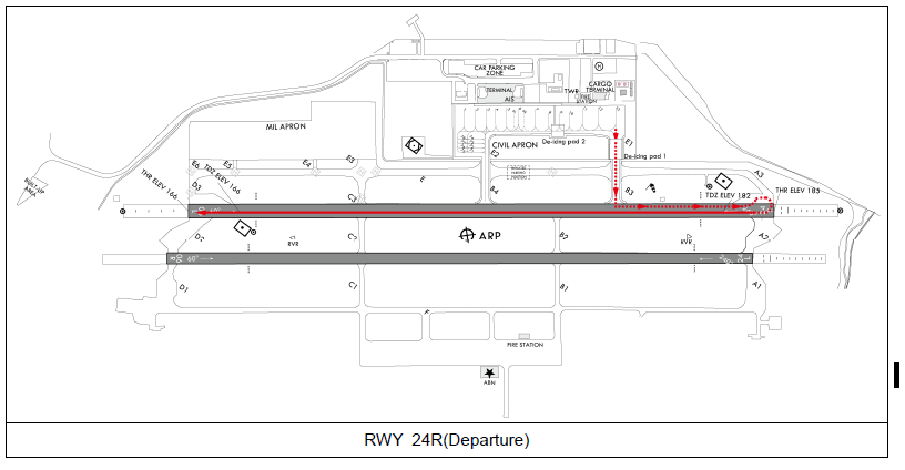
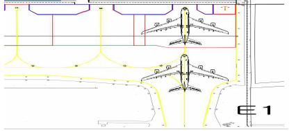
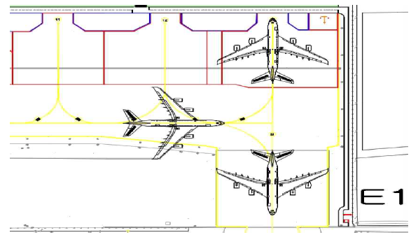
RWY 24R : Apron → E1 → E → A3 → RWY 24R threshold
RWY 06L : Apron → E1 → B3 → RWY 06L turnpad → RWY 06L threshold
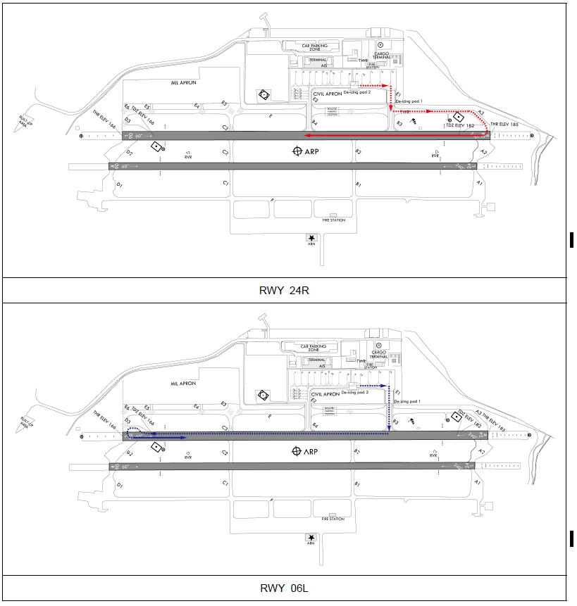
RWY 24R : RWY 24R threshold → RWY 06L turnpad → B3 → E1 → Apron
RWY 06L : RWY 06L threshold → RWY 24R turnpad → A3 → E1 → Apron
| Aircraft stands |
Aircraft code (ICAO) |
Restrictions |
| 6L |
ICAO code letter “C” |
a. Boarding bridge is unserviceable. b. When ACFT stand NR. 7 is used by ICAO code letter "D" or above, ACFT stand NR. 6R shall be unserviceable. |
| 6R |
2 Ground Procedure
- Departure
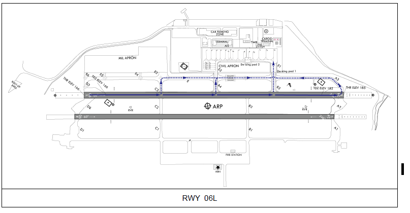
- Unless otherwise cleared by ATC, aircraft are advised to taxi to holding point as follow.
RWY
TAXI Procedure
06L
Aircraft taxi to RWY 06L by using E2, E, D3
24R
Aircraft taxi to RWY 24R holding position by using E1, E
-
RWY 06L holiding position marking is located at 90m from RWY centerline and RWY 24R holiding position marking is located at 301 m from end of RWY on TWY E.
-
If unable to follow the above taxiing routes, the pilot should notify it to ATC.
-
All aircraft shall not enter the TWY A3 and RWY Unless cleared by ATC.
- Unless otherwise cleared by ATC, aircraft are advised to taxi to holding point as follow.
-
Arrival
-
Unless otherwise cleared by ATC, aircraft are advised to taxi using arrival routes.
(Aerodrome regulations - 4. Arrival procedure - 4.2 Arrival routes)
-
If unable to follow the above RWY vacating routes, the pilot should notify it to ATC.
-
-
Departure
-
All aircraft taxiing to RWY 06L/24R should change radio frequency from GND(121.875) to TWR(118.7) when entering the designated TWY as follows - A3, B3, B4, C3, and D3.
-
-
Arrival
-
All aircraft vacating RWY 06L/24R should change radio frequency from TWR(118.7) to GND(121.875) when entering designated TWY as follows - A3, B3, B4, C3, and D3.
-
Pilots should always operate transponders with XPNDR(and AUTO if available) except for fully parking aircraft on stand.
3 Departure Procedure
Aircraft shall obtain ATC clearance from Cheong-Ju GND prior to pushback.
-
When a pilot is ready for start-up and pushback, the pilot shall contact Cheong-Ju GND and provide the following :
-
Call sign
-
Gate/Stand number
-
Type of request, engine start
-
-
Unless there is any special situation, priority to make push back will be given to aircraft operators who requested first.
-
For safety reasons, ground crews must clear the equipment, vehicles and other obstacles before aircraft makes push back or start-up engine.
-
A pilot shall confirm with ground crews (Ground handler, aircraft maintenance) whether there is no hazard to the aircraft starting up. The pilot shall not ask Cheong-Ju GND for engine start-up and push back until its safety check-up is fully confirmed. If there is any elements posing a potential failure, the pilot shall ask Cheong-Ju GND for push back only. After moving and standing the aircraft at a safety area, the pilot can ask for engine start-up.
-
The push back procedures of the aircraft within the 1 Apron are as follows. As with most, these procedures shall be kept. However, if any modification of the procedures is required as the case may be, Cheong-Ju GND may give the pilot specific instructions suited for the safety of aircraft movement.
-
Delays on the aircraft's pushback may be expected in order to maintain the distance of taxiing or pushback of other aircraft.
-
Unless otherwise instructed, pushback procedures are as follows.
Aircraft stands
RWY in use
Pushback
Procedures
Phraseology
1~13
06L
The aircraft shall be
pushed back to face E2
Push back
approved to face E2
1~13
24R
The aircraft shall be
pushed back to face E1
push back
approved to face E1
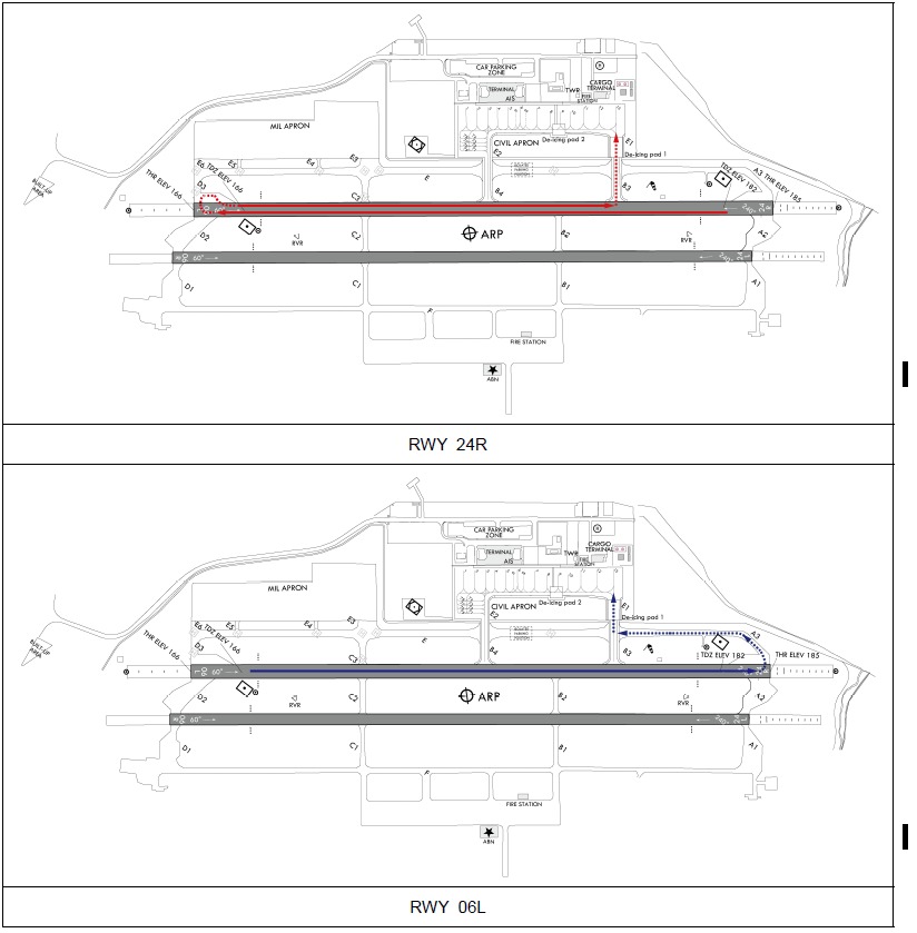
Unless otherwise instructed, aircraft shall follow the routes below.
| RWY |
Departure routes |
| RWY 06L |
Apron → E2 → E → D3 |
| RWY 24R |
Apron → E1 → E → RWY 24R holding point → A3 |
-
De-icing pad located in TWY E1 is de-icing pad 1(below code letter “E” available), and the one located behind spot NR. 8 - 9 is de-icing pad 2(below code letter “D” available).
-
De-icing Pad Operation
-
Aircraft Operator has to notice to the Ground operator When he/she wants to use De-icing Pad.
-
Ground operator must notify authorized person about various matters related to operation procedure.
-
When using a de-icing pad, notify GND before pushback.
-
-
De-icing Pad Movement
Aircraft operator has to maintain a communication system which is connecting with de-icing working.
-
It is available to make intersection departure on RWY 06L/24R via B3/B4/C3.
-
Intersection departure is only available when requested by pilots.
-
The length of available RWY refers to RKTU AD 2.13 DECLARED DISTANCES.
-
When necessary, aircraft may obtain intersection departure clearance while taxiing.
4 Arrival Procedure
-
Unless otherwise instructed by ATC, aircraft shall follow the routes below.
RWY in use
Arrival routes
RWY 06L
A3/B3/B4/C3 → E → E1 → Apron
RWY 24R
B3/B4/C3/D3 → E → E2 → Apron
-
If speed adjustment of aircraft could be completed, It is available to vacate the RWY 06L/24R via TWY B3/B4/C3.
-
When vacating RWY via C3/D3, aircraft shall not to enter TWY E3/E4/E5/E6 unless authorized.
.png)
5 ICAO code letter "F" aircraft procedures for the usage of the alternate airport, RKTU
-
Departure
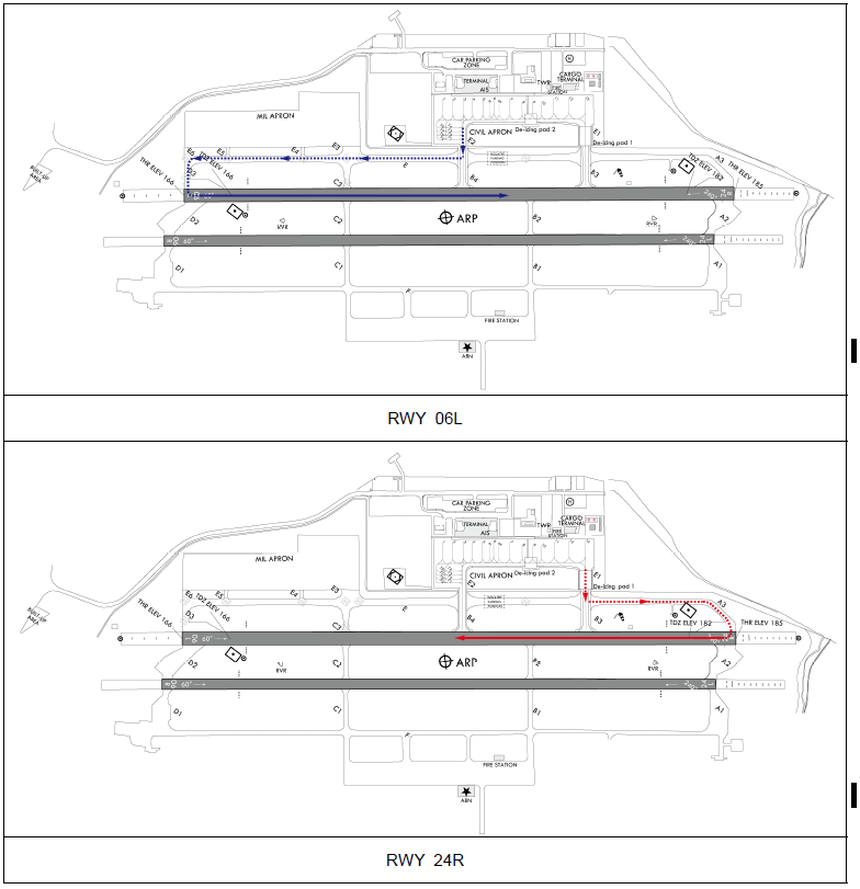
RWY 24R : ACFT stand NR. 13 → E1 → B3 → 24R RWY turn pads → 24R RWY threshold
RWY 06L : ACFT stand NR. 13 → E1 → B3 → 06L RWY turn pads → 06L RWY threshold
.png)
-
Arrival
RWY 24R : 24R RWY Threshold → 06L RWY turn pads → B3 → E1 → ACFT stand NR. 13
RWY 06L : 06L RWY Threshold → 24R RWY turn pads → B3 → E1 → ACFT stand NR. 13

-
ICAO code letter “F” aircraft are not able to take-off or land on RWY 06R/24L.
-
ICAO code letter “F” aircraft shall enter the apron via TWY B3, TWY E1 and shall not move via TWY B4, TWY E2.
-
After take off or landing of ICAO code letter “F” aircraft, take-off or landing of any other aircraft should be prohibited on RWY 06L/24R until RWY checking and removing FOD are finished.
-
Aircraft TOW and LDW for the usage of the alternate airport shall be restricted as follows.
A/C TYPE
MTOW
LDW
A380
400 ton
386 ton
B747-8
353.8 ton
344.3 ton
-
When necessary for FOD prevention, Special take off precedures (A380 Flight crew operation manual) can be performed under the condition that the total width of RWY plus shoulder pavement has less than 58 m.
-
The standard taxi routes for ICAO code letter "F" aircraft are as follows. :
-
Taxi-in Procedures
-
Push-back Procedures
-
-
On the area of RWY, TWY B3, TWY E1 (including the curved part of TWY) and apron, ICAO code letter "F" aircraft should move at a speed of below 30 kt except for the departure maneuvering, which pilots should make his engines idle power, adjusting the speed only with operating brake system by inertia. Especially, A380 movement procedure is as follows. :
A380 Landing maneuvering
Section
Status of engine
Speed
No. 2 & 3
No. 1 & 4
Runway maneuvering
Idle power
Idle power
- Below 30 kt
Turning pad
Idle power
Idle power
- Maintain 5 kt
- Below 30 kt (After turning)
Taxiway/Apron
Idle power
Shut down
- 7~8 kt
A380 Departure maneuvering
Section
Status of engine
Speed
No. 2 & 3
No. 1 & 4
Taxiway/Apron
Idle power
Idle power
- 7~8 kt
Runway maneuvering
Idle power
Idle power
- Below 30 kt
Turning pad
Idle power
Idle power
- Maintain 5 kt
- Below 30 kt (after turning)
※ A380 Aircraft to be taxied with their engine thrust 4~6% (When turning, aircraft should keep 10% thrust using one outer engine of opposite turning direction).
RKTU AD 2.21 NOISE ABATEMENT PROCEDURES
| NIL |
RKTU AD 2.22 FLIGHT PROCEDURES
1 Weather Minima
| RWY 06L/24R |
||
| ENG |
HIRL & RCLL or RCL |
Others |
| 2 or more ENG |
RVR / VIS 500 m |
RVR / VIS 800 m |
| RWY |
CAT |
DH/MDA-VIS |
CEIL-VIS |
|
| PAR |
06L |
ABCDE |
368/24 |
(200-½) |
| 24R |
ABCDE |
386/24 |
(200-½) |
|
| ALS inop |
increase vis ¼mile |
|||
| ASR |
06L |
AB |
620/24 |
(500-½) |
| C |
620/40 |
(500-¾) |
||
| DE |
620/50 |
(500-1) |
||
| 24R |
AB |
860/24 |
(700-½) |
|
| C |
860-1½ |
(700-1½) |
||
| D |
860-1¾ |
(700-1¾) |
||
| E |
860-2 |
(700-2) |
||
| ALS inop |
increase vis ½mile |
|||
| CIRCLING |
06L |
A |
780-1 |
(600-1) |
| B |
820-1 |
(700-1) |
||
| C |
820-1¾ |
(700-1¾) |
||
| D |
1 200-3 |
(1100-3) |
||
| E |
1220-3 |
(1100-3) |
||
| 24R |
AB |
860-1 |
(700-1) |
|
| C |
860-2 |
(700-2) |
||
| D |
1 200-3 |
(1100-3) |
||
| E |
1220-3 |
(1100-3) |
||
| Circling not auth SE of RWY 06-24, RWY 24-06 |
||||
| ILS |
06L |
ABCD |
367/40 |
(200-¾) |
| ALS inop |
367/45 |
(200-⅞) |
||
| 24R |
ABCD |
387/24 |
(200-½) |
|
| ALS inop |
387/40 |
(200-¾) |
||
| LOC |
06L |
AB |
700/40 |
(600-¾) |
| CD |
700-1¼ |
(600-1¼) |
||
| AB(ALS inop) |
700/55 |
(600-1) |
||
| CD(ALS inop) |
700-1½ |
(600-1½) |
||
| CIR (LOC Y APP’) |
AB |
880-1 |
(700-1) |
|
| C |
1 200-3 |
(1100-3) |
||
| D |
2000-3 |
(1900-3) |
||
| 24R |
AB |
620/24 |
(500-½) |
|
| CD |
620/40 |
(500-¾) |
||
| AB(ALS inop) |
620/55 |
(500-1) |
||
| CD(ALS inop) |
620-1¼ |
(500-1¼) |
||
| CIR (LOC Y APP’) |
AB |
880-1 |
(700-1) |
|
| C |
1 200-3 |
(1100-3) |
||
| D |
2000-3 |
(1900-3) |
||
| VOR |
06L |
AB |
700/24 |
(600-½) |
| C |
700/50 |
(600-1) |
||
| D |
700/60 |
(600-1¼) |
||
| CIR 06L |
A |
780-1 |
(600-1) |
|
| B |
820-1 |
(700-1) |
||
| C |
820-1¾ |
(700-1¾) |
||
| D |
1 200-3 |
(1100-3) |
||
| 6L ALS inop |
increase CAT AB RVR 50 and vis 1mile increase CAT C vis 1½mile increase CAT D vis 1¾mile |
|||
| 24R |
AB |
860/24 |
(700-½) |
|
| C |
860-1½ |
(700-1½) |
||
| D |
860-1¾ |
(700-1¾) |
||
| CIR 24R |
AB |
860-1 |
(700-1) |
|
| C |
860-2 |
(700-2) |
||
| D |
1 200-3 |
(1100-3) |
||
| 24R ALS inop |
increase CAT AB RVR 50 and vis 1mile increase CAT C vis 2mile increase CAT D vis 2¼mile |
|||
| RNP |
06L S-LNAV/VNAV |
ABCD |
625-1¼ |
(500-1¼) |
| ABCD (ALS inop) |
625-1½ |
(500-1½) |
||
| 06L S-LNAV |
ABCD |
620-1¼ |
(500-1¼) |
|
| ABCD (ALS inop) |
620-1½ |
(500-1½) |
||
| 24R S-LNAV/VNAV |
ABCD |
602/40 |
(500-⅞) |
|
| ABCD (ALS inop) |
602-1⅜ |
(500-1⅜) |
||
| 24R S-LNAV |
ABCD |
620/40 |
(500-¾) |
|
| ABCD (ALS inop) |
620/55 |
(500-1) |
||
| RWY |
CAT |
DH/MDA-VIS |
CEIL-VIS |
|
| PAR |
06R |
A, B, C, D, E |
372/40 |
(200-¾) |
| 24L |
A, B, C, D, E |
392/24 |
(200-½) |
|
| 24L ALS INOP |
Increase VIS ¼ mile. |
|||
| ASR |
06R |
A, B |
620/50 |
(500-1) |
| C |
620-1¼ |
(500-1¼) |
||
| D, E |
620-1½ |
(500-1½) |
||
| 24L |
A, B |
880/40 |
(700-¾) |
|
| C |
880-1½ |
(700-1½) |
||
| D |
880-1¾ |
(700-1¾) |
||
| E |
880-2 |
(700-2) |
||
| 24L ALS INOP |
Increase CAT A, B VIS ¼ mile. Increase CAT C, D, E VIS ½ mile. |
|||
| CIRCLING |
06R |
A |
780-1 |
(600-1) |
| B |
820-1 |
(700-1) |
||
| C |
820-1¾ |
(700-1¾) |
||
| D |
1 200-3 |
(1 100-3) |
||
| E |
1 220-3 |
(1 100-3) |
||
| 24L |
A, B |
880-1 |
(700-1) |
|
| C |
880-2 |
(700-2) |
||
| D |
1 200-3 |
(1 100-3) |
||
| E |
1220-3 |
(1 100-3) |
||
| Circling not AUTH SE of RWY 06-24, RWY 24-06. |
||||
2 VFR
-
General Conditions
-
Helicopters using civil aprons for taking off or landing shall be made on TWY E.
For helicopters with wheel-type landing gear, take-off/landing/taxiing shall be conducted on the runway only after obtaining the permission from the control tower.
-
After take-off, aircraft shall depart the traffic pattern to the northwest and any aircraft which want to take-off and cross the RWY 06R/24L shall obtain the prior permission from the control tower.
-
Traffic pattern altitude for helicopters is 1 000 ft except for B-412 helicopter and light aircraft.
-
-
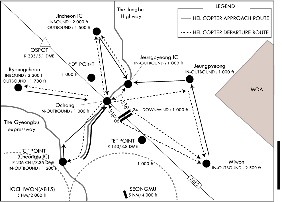
Procedure for departing traffic pattern (refer to the diagram)
-
RWY 24L/R in use
-
For aircraft departing the traffic pattern to the north
Turn right after take-off, then fly to the right side of OCHANG at 1 000 ft with broadcasting the position in the blind. Fly to the right side of the National road 17 while keeping a sharp lookout for other aircraft entering or leaving Jincheon branch office(360°R 6 NM), the Forest Government Information Agency, then fly to the left side ABEAM of the Jincheon Casemate(launching pad) at 1 500 ft and after broadcasting the position in the blind over the JINCHEON, depart to the destination.
-
For aircraft departing the traffic pattern to the west
After take-off, turn right and fly via OCHANG at 1 000 ft with broadcasting the position in the blind, then proceed to BYONGCHEN at 1 700 ft along the south of the National road 510, and after broadcasting the position in the blind over BYONGCHEN, depart to the destination.
-
For aircraft departing the traffic pattern to the south
-
Take-off for crossing the runway 06R/24L shall be allowed only after obtaining the permission from the control tower.
-
After take-off, turn left after obtaining the permission from the control tower and proceed direct to "C" Point at 1 200 ft.
-
After take-off, maintain at or below 500 ft until passing through the end of the runway, and turn left after obtaining the permission from the control tower, depart to the destination via MIWON at 2 500 ft.
-
If no permission is obtained from the control tower, maintain at or below 500 ft until passing the end of the runway, and turn right, then fly along the right side of JUNGBU Expressway, and after broadcasting the position in the blind over "C" Point at 1 200 ft, depart to the destination.
-
-
For aircraft departing the traffic pattern to the east
After take-off, turn right and proceed to JEUNGPYEONG at 1 000 ft via 'Down Wind leg' and depart to the destination after broadcasting the position in the blind over JEUNGPYEONG; or
After obtaining the permission from the control tower, cross the extended centerline of runway at or below 1 000 ft and depart to the destination.
-
-
RWY 06L/R in use
-
For aircraft departing the traffic pattern to the north
After take-off, turn left and maintain at or below 800 ft. Fly via the right side of JEUNGPYEONG Interchange at 1 000 ft. Proceed to JINCHEON at 1 500 ft along the JUNGBU Expressway and depart to the destination after broadcasting the position in the blind over JINCHEON.
-
For aircraft departing the traffic pattern to the west
After take-off, turn left and maintain at or below 800 ft. Fly via the right side of OCHANG at 1 000 ft along JUNGBU Expressway. and proceed to BUNGCHEON at 1 700 ft along the National road 510, and Depart to the destination after broadcasting the position in the blind over BUNGCHEON.
-
For aircraft departing the traffic pattern to the south
-
Take-off for crossing the runway 06R/24L shall be allowed only after obtaining the permission from the control tower.
-
After take-off, maintain at or below 500 ft until passing through the end of the runway, and after obtaining the permission from the control tower, turn right and depart to the destination via MIWON at 2 500 ft.
-
When departing the traffic pattern via "C" point, turn right after passing through the end of runway and proceed to "C" Point at 1 200 ft via Down wind and Depart to the destination after broadcasting the position in the blind over "C" Point.
-
Flying directly over downtown and school areas of Byeongcheon, Miwon and Ochang is prohibited.
-
-
-
-
Procedure for entering traffic pattern
-
For aircraft entering the traffic pattern from the southwest
Request landing clearance at "C" Point at 1 200 ft then along the Mihocheon and right side of the Jungbu Expressway.
Maintain at or below 1 000 ft until passing Runway extension line.
-
For aircraft entering the traffic pattern from the west
After broadcasting the position in the blind over the Mokcheon Interchange, fly to the right side of Byeongcheon(right side of National road 21), then request landing clearance at Byeongcheon at 2 200 ft.
Fly along the north of National Road 510, proceed to OCHANG at 1 500 ft and then enter the traffic pattern by descending to 1 000 ft.
-
For aircraft entering the traffic pattern from the north
Request landing clearance at Jincheon at 2 000 ft after broadcasting the position in the blind over Gwanghyewon and enter the traffic pattern via the right side of Jeungpyeong Interchange or via Ochang.
-
For aircraft entering the traffic pattern from the east
After broadcasting the position in the blind over Goesan, request landing clearance over Jeungpyeong at 1 000 ft, and enter the traffic pattern via Jeungpyeong Interchange at 1 000 ft.
-
For aircraft entering the traffic pattern from the northeast
After broadcasting the position in the blind over Eumseong, request landing clearance at Jeungpyeong at 1 000 ft, and enter the traffic pattern via Jeungpyeong Interchange at 1 000 ft.
* Flying directly over downtown and school areas of Byeongcheon, Miwon and Ochang is prohibited.
-
For aircraft entering the traffic pattern from the southeast
Fly via Miwon at 2 500 ft and request landing clearance at Jeungpyeong at 1 000 ft, Enter the traffic pattern via Jeungpyeong Interchange at 1 000 ft.
-
When RWY 06 R/L is in use, enter the traffic pattern by maintaining 1 000 ft over Ochang.
VFR aircraft reporting points
Jincheon
365127.01N 1272602.64E
"C"
363737.50N 1272259.60E
Jeungpyeong
364640.00N 1273630.00E
Ochang
364434.03N 1272747.39E
"D"
364546.75N 1272620.05E
Miwon
364305.06N 1273924.42E
Byeongcheon
364546.75N 1271800.32E
Jeungpyeong IC
364621.81N 1273025.87E
"O"
364851.41N 1272404.68E
"P"
364941.23N 1272957.93E
-
-
General Conditions
-
Use the runway 06L/24R and parking shall be made on civil ramp.
-
Unless otherwise cleared by ATC, Use TWY B3/B4/C3 for departing and after landing RWY.
-
Use northern traffic pattern and maintain pattern altitude 1 200 ft(AMSL).
-
Pattern Traffic is only allowed up to 3 flights.
-
Flight plan must be submitted 17:00, one day before the flight.
-
-
Possible time for flight
-
Weekdays
-
Setting Military jet aircraft’s flight time as a standard, flight for light aircraft is allowed 1hour 30mins. Before the military jet aircraft’s flight, and 30mins after military jet aircraft’s flight during daytime.
During nighttime, flight for light aircraft is allowed 1hour before military jet aircraft’s flight and 30mins after military jet aircraft’s flight.
-
Setting Helicopter’s flight time as a standard, flight for light aircraft are allowed 15min before Helicopter’s takeoff and 15mins after helicopter’s flight.
-
Flights during morning time in weekdays is allowed after 07:00 under the condition that it suits the clause 1) and 2) above.
-
-
Weekends
-
09:00~12:00, 13:00~17:00, 18:00~21:00
-
Light aircraft departing to other airport or arriving from other airport can only depart before 09:00 and arrive after 21:00.
-
-
-
Procedure for departing(refer to the diagram)
-
RWY 24R in use
- Turn right in 1NM after take-off then direct to the destination via O point(2 500 ft). Turn left after take-off shall be allowed after obtaining the permission from the control tower.
-
RWY 06L in use
- Turn left in 1 NM after take-off then direct to the destination via P point(2 500 ft). Turn right after take-off shall be allowed after obtaining the permission from the control tower.
-
-
Procedure for landing(refer to the diagram)
-
RWY 24R in use
-
For entering from the north or northeast REPORT outside of 10 NM from the ARP Downwind enter via “P“ point(3 000 ft).
-
For entering from the west or northwest REPORT outside of 10 NM from the ARP Downwind enter via “O“ point(3 000 ft).
-
For entering from the south or east REPORT outside of 10 NM from the ARP before crossing the extended centerline of runway. Land via “O“ point(3 000 ft) or “P“ point(3 000 ft) or when traffic is no factor land via “O“ point(3 000 ft) or “P“ point(3 000 ft) after passing over the airport(4 500 ft).
-
Follow traffic seperation and condition enter after holding at O point(3 000 ft) or P point(3 000 ft) or direct Downwind enter.
-
-
RWY 06L in use
-
For entering from the north or northeast REPORT outside of 10 NM from the ARP. Downwind 1 000 ft enter from O point(3 000 ft) or Downwind enter via “P“ point(3 000 ft) or “O“ point(3 000 ft)
-
For entering from the west or northwest REPORT outside of 10 NM from the ARP. Downwind enter via “O“ point(3 000 ft).
-
For entering from the south or east REPORT outside of 10 NM from the ARP before crossing the extended centerline of runway. Land via “O“ point(3 000 ft) or “P“ point(3 000 ft) or when traffic is no factor land via “O“ point(3 000 ft) or “P“ point(3 000 ft) after passing over the airport(4 500 ft).
-
Follow traffic seperation and condition enter after holding at O point(3 000 ft) or P point(3 000 ft) or direct Downwind enter.

-
-
-
Procedure for transit from the southwest(refer to the diagram)
VFR aircraft entry point
Yongmoon
364228N 1270709E
Cheonan JCT
364606N 1271044E
Independence Hall
364708N 1271313E
-
For entering from the southwest PASS through Yongmoon, Cheonan JCT and Independence Hall(2 500 ft at or below)

-
3 Radio Communication Failure Procedure
-
General
-
No person may take off unless two-way radio communication can be maintained with the Air Traffic Control.
-
On recognition of communication failure during flight, squawk 7600 and if necessary to ensure safe altitude, climb to Minimum Safe Altitude or above to maintain obstacle clearance. Then comply with following procedures
-
-
VFR condition
If the failure occurs in VFR conditions, or if VFR conditions are encountered after the failure, each pilot shall continue the flight under VFR and land as soon as practicable.
-
IFR condition
If the failure occurs in IFR conditions, or if paragraph 2 of this section cannot be complied with, each pilot shall continue the flight according to the following.
-
DEPARTURE
-
Under Pilot Navigation
RWY 24 in use
1) RNAV OLREG 1-
Climb on 240° course to OLREG, then...via(transition) and maintain 6 000.
- GUKDO TRANSITION(OLREG 1, GUKDO) :...330° track to LAVAX, then via 060° track to TUTAE, then via 044° track to GUKDO.
- OSPOT TRANSITION(OLREG 1, OSPOT) :...330° track to LAVAX, then via 035° track to OSPOT.
- OLMEN TRANSITION(OLREG 1, OLMEN) :...291° track to OLMEN, cross OLMEN at or above 8 000.
- BITUX TRANSITION(OLREG 1, BITUX) :... 330° track to LAVAX, then via 060° track to PUGOX, then via 150° track to LEDUD, then via 164° track to BOEUN, then via 141° track to BITUX.
RWY 06 in use
1) RNAV BUKIL 1
-
Climb on 060° course to BUKIL, then... via(transition) and maintain 6000.
- GUKDO TRANSITION(BUKIL1. GUKDO) : ...007° track to GUKDO, cross GUKDO at or above 8 000.
- OSPOT TRANSITION(BUKIL1. OSPOT) :...330° track to TUTAE, then via 252° track to OSPOT.
- OLMEN/BULTI TRANSITION(BUKIL1. OLMEN/BULTI) :...330° track to TUTAE, then via 240° track to OWING, then via 280° track to OLMEN/BULTI.
- BITUX TRANSITION(BUKIL1. BITUX) :...330° track to TUTAE, then via 240° track to OLDIX, then via 150° track to MIGUL, then via 141° track to BOEUN, then via 141° track to BITUX.
-
-
Under Radar vectoring
- Proceed with the route from the point of radio failure to the fix, route, or airway specified in vector clearance,
- In the absence of an assigned route, proceed with the route that ATC has advised, which may be expected in a further clearance, or
- In the absence of an assigned route or a route that ATC has advised, which may be expected in a further clearance, proceed with the route filed in the flight plan, and
- Maintain minimum en-route altitude (MEA) or the altitude/flight level cleared in the last ATC clearance received, whichever is higher, for 5 minutes
- Continue the flight with altitude, flight level filed in the flight plan.
-
-
ARRIVAL
RWY 24 in use
-
VFR condition
The aircraft shall maintain VFR and make an approach to land at RWY 24 passing ICHG 7 DME FINAL.
-
IFR condition
The aircraft shall proceed to IKAPO IAF and execute ILS/DME Y/Z RWY 24R or VOR/DME RWY 24R or RNAV RWY 24R or LOC/DME 24R APP.
RWY 06 in use
-
VFR condition
The aircraft shall maintain VFR and make an approach to land at RWY 06 passing SAPUX 6 DME FINAL.
-
IFR condition
The aircraft shall proceed to JIKJI IAF and execute RNAV RWY 06L APCH.
-
-
-
VFR flight which has encountered radio communication failure shall
-
Helicopter
- SQ 7600, and
- When able to see light gun signal from control TWR, follow that instruction
- If unable to see light gun signal from control TWR, hold over downwind until ETA or for 10 minutes, whichever is later, then
- Land on RWY in use as filed, and take caution of landing and departing traffic.
-
-
Conventional flight
- SQ 7600, and
- When able to see light gun signal from control TWR, follow that instruction
- If unable to see light gun signal from control TWR, hold on downwind until ETA or for 10 minutes, whichever is later, then
- Aircraft should land on RWY in use
- Pilot shall take caution of landing and departing traffic.
RKTU AD 2.23 ADDITIONAL INFORMATION
-
Bird concentrations in the vicinity of the airport
-
Due to bird habitats in the vicinity of airport, pilots shall exercise caution not to conflict with the birds.
-
The activity altitude of birds is from 0 to 500 ft(150 m).
-
Also, before daily sunset, activities of the birds occur above the same way when returning to the resting area during 1 hour or 2 hours.
-
Control tower shall provide pilots with the information about the birds’s movement.
-
Monthly bird activies is as follows :
-
From January to March, and from October to December : During 1 hour or 2 hours after daily sunrise, birds like dove or duck mallard move from resting area (approximately 4~12 km to the southwest of threshold of Runway 24R/06L) to feeding area(farmlands or airport).
-
From April to September : During 1 hour or 2 hours after daily sunrise, birds like white-plumed egret and grey heron move from resting area(mountains which are located in approximately 1 km far from the airport) to feeding area(farmlands or airport).
-
Also, resident birds, such as magpie, skylark or sparrow, move in and out agricultural area near airport.
-
-
Preventive activities against bird strikes, such as operation of B.A.T(Bird Alert Team) and devices(cannon, shotgun, etc) which scare birds away, shall be carried out. Also, the measures for eliminating resting or feeding area of birds is being taken in the airport boundary.
-
On the properties of airport farming, garbage treatment facilities are not permitted.
