RKSM — Seoul
RKSM AD 2.1 AERODROME LOCATION INDICATOR AND NAME
RKSM - SEOUL / Domestic
RKSM AD 2.2 AERODROME GEOGRAPHICAL AND ADMINISTRATIVE DATA
| 1 |
ARP coordinates and site at AD |
372645N 1270651E |
| 2 |
Direction and distance from city |
1.5 km SE of Seongnam City Hall |
| 3 |
Elevation/Reference temperature |
28 m / 29°C |
| 4 |
Geoid undulation at AD ELEV PSN |
NIL |
| 5 |
MAG VAR/Annual change |
8.0° W (201 7) / 0.07° increasing |
| 6 |
Aerodrome Operator, Address, Telephone, Telefax, AFS |
Post:
Republic of Korea Airforce Seoul Airbase 1210 Daewangpangyo-ro, Sujeong-gu, Seongnam-si, Gyeonggi-do, 13103 Republic of Korea Tel: Tel : +82-31-720-3277 Fax: Telefax : +82-31-720-4457 AFS: AFS : RKSMZPZX |
| 7 |
Type of traffic permitted(IFR/VFR) |
IFR/VFR |
| 8 |
Remarks |
Military Air Base |
RKSM AD 2.3 OPERATIONAL HOURS
| 1 |
Aerodrome Operator |
2100-1300UTC* |
| 2 |
Customs and Immigration |
As AD Operational Hour |
| 3 |
Health and Sanitation |
HS |
| 4 |
AIS Briefing Office |
H24 |
| 5 |
ATS Reporting Office |
H24 |
| 6 |
MET Briefing Office |
H24 |
| 7 |
ATS |
H24 |
| 8 |
Fuelling |
HS |
| 9 |
Handling |
HS |
| 10 |
Security |
NIL |
| 11 |
De-icing |
H24 |
| 12 |
Remarks |
Noise Abatement-Prohibit strictly enforced, no ARR/DEP BTN city quiet hour 1300-2100Z DLY WO K-16 Command Post APV. CTC Command Post +82-31-720-3233 at least 48HR in advance. DRG quiet HR unsuppressed ENG runs and nonessential ACFT OPR are prohibited. |
RKSM AD 2.4 HANDLING SERVICES AND FACILITIES
| 1 |
Cargo handling facilities |
HS |
| 2 |
Fuel/oil types |
Jet A-1/JP-8/AV Gas |
| 3 |
Fuelling facilities/capacity |
HS |
| 4 |
De-icing facilities |
H-1 Heater |
| 5 |
Hangar space for visiting aircraft |
NIL |
| 6 |
Repair facilities for visiting aircraft |
No limitations at any time, service available. |
| 7 |
Remarks |
NIL |
RKSM AD 2.5 PASSENGER FACILITIES
| 1 |
Hotels |
Near the AD and in the city (Seoul and Sungnam) |
| 2 |
Restaurants |
Near the AD and in the city (Seoul and Sungnam) |
| 3 |
Transportation |
Buses, Taxis from the AD |
| 4 |
Medical Facilities |
|
| 5 |
Bank and Post Office |
Near the AD and in the city |
| 6 |
Tourist Office |
NIL |
| 7 |
Remarks |
NIL |
RKSM AD 2.6 RESCUE AND FIRE FIGHTING SERVICES
| 1 |
AD Category for fire fighting |
NIL |
| 2 |
Rescue equipment |
|
| 3 |
Capability for removal of disabled aircraft |
By arrangement |
| 4 |
Remarks |
* Aqueous Film Forming Foam (AFFF) |
RKSM AD 2.7 SEASONAL AVAILABILITY - CLEARING
| 1 |
Type of clearing equipment |
3 Snow removal truck with plough (Working width about 4.5 m) |
| 2 |
Clearance priorities |
|
| 3 |
Remarks |
NIL |
RKSM AD 2.8 APRONS, TAXIWAYS AND CHECK LOCATIONS DATA
| 1 |
Apron surface and strength |
Surface : Concrete |
| 2 |
Taxiway width, surface and strength |
Width : 23 m Surface : concrete |
| 3 |
Altimeter checkpoint location and elevation |
9 3 ft |
| 4 |
VOR checkpoints |
NIL |
| 5 |
INS checkpoints |
NIL |
| 6 |
Remarks |
NIL |
RKSM AD 2.9 SURFACE MOVEMENT GUIDANCE AND CONTROL SYSTEM AND MARKINGS
| 1 |
Use of aircraft stand ID signs, TWY guide lines and visual docking/parking guidance system of aircraft stands |
Taxing guidance signs at all intersections with TWY & RWY and holding position, Guide lines at apron Nose-in guidance at aircraft stands |
| 2 |
RWY and TWY markings and LGT |
RWY 19/20 - LGT : Edge, THR, End - Marking : THR, TDZ TWYs - LGT : TWY edge lights - All TWY - Marking : TWY & taxilane centerline marked, Holding positions at all TWY/RWY intersections marked |
| 3 |
Stop bars |
NIL |
| 4 |
Remarks |
NIL |
RKSM AD 2.10 AERODROME OBSTACLES
| In Area 2 |
|||||
| OBST ID/ Designation |
OBST type |
OBST position |
ELEV/HGT |
Markings/ Type, colour |
Remarks |
| a |
b |
c |
d |
e |
f |
| RKSMOB001 |
Mt.Bamgogae |
372804.8N 1270641.1E |
237 ft |
19/20APCH 1/2TKOF |
|
| RKSMOB002 |
Building (GARDEN 5) |
372841.9N 1270707.6E |
238 ft |
19/20APCH |
|
| RKSMOB003 |
Mt.Baemae |
372529.1N 1270640.5E |
184 ft |
19/20TKOF |
|
| RKSMOB004 |
Mt.Giji(S) |
372524.8N 1270645.9E |
187 ft |
19/20TKOF |
|
| RKSMOB005 |
Mt.Siheung(S) |
372449.0N 1270621.7E |
356 ft |
19TKOF |
|
| RKSMOB006 |
Mt.Siheung(E) |
372503.6N 1270647.4E |
277 ft |
1/2APCH 20TKOF |
|
| In Area 3 |
|||||
| OBST ID/ Designation |
OBST type |
OBST position |
ELEV/HGT |
Markings/ Type, colour |
Remarks |
| a |
b |
c |
d |
e |
f |
| RKSMOB001 |
Mt.Yongma |
373416.2N 1270544.6E |
1 146 ft |
19APCH |
|
| RKSMOB002 |
Mt.Manguli |
373530.2N 1270644.1E |
926 ft |
19/20APCH |
|
| Remarks |
|||||
| Caution
|
|||||
RKSM AD 2.11 METEOROLOGICAL INFORMATION PROVIDED
| 1 |
Associated MET Office |
SEOUL AIRFORCE MET OFFICE (TEL:+82-31-720-3292) |
| 2 |
Hours of service MET Office outside hours |
H24 |
| 3 |
Office responsible for TAF preparation Periods of validity |
ROKAF MET Office 30 hours at 0000, 0600, 1200, 1800 UTC |
| 4 |
Trend forecast Interval of issuance |
1 hour(METAR) and when SPECI reported |
| 5 |
Briefing/consultation provided |
Personal consultation, Telephone |
| 6 |
Flight documentation Language(s) used |
English/Korean |
| 7 |
Charts and other information available for briefing or consultation |
Surface analysis chart Upper air analysis Prognosis chart Significant weather chart |
| 8 |
Supplementary equipment available for providing information |
NIL |
| 9 |
ATS units provided with information |
Seoul TWR, Seoul APP, Seoul GCA |
| 10 |
Additional information (limitation of service, etc.) |
NIL |
RKSM AD 2.12 RUNWAY PHYSICAL CHARACTERISTICS
| Designations Runway NR |
TRUE BRG |
Dimension of RWY(FT) |
Strength(PCN) and surface of RWY and SWY |
THR coordinates RWY end coordinates THR geoid undulation |
THR elevation and highest elevation of TDZ of precision APP RWY |
|---|---|---|---|---|---|
| 1 |
2 |
3 |
4 |
5 |
6 |
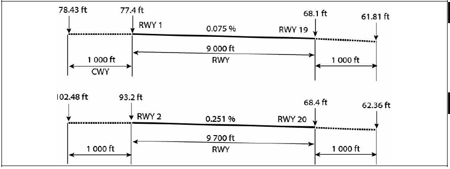
| 01 | 1. 79 |
9 000 × 150 |
PCN 82R/ B /W/T |
372602.6 N |
THR 77.4 ftTDZ 77.4 ft |
| 19 |
181. 79 |
9 000 x 150 |
PCN 82R/ B /W/T |
372731. 6N |
THR 68. 1 ft |
| 02 |
8. 1 0 |
9 700 x 150 |
PCN 85R/B/X/T |
372556.6 N |
THR 93. 2 ft |
| 20 |
188. 1 0 |
9 700 x 150 |
PCN 85R/B/X/T |
372731. 6 N |
THR 68.4 ft |
| 7. Slope of RWY-SWY |
|||||
|
|||||
| SWY dimensions(M) |
CWY dimensions(M) |
Strip dimensions(M) |
OFZ |
||
| 8 |
9 |
10 |
11 |
||
| NIL |
1 000 X 150 |
9 390 X 450 |
NIL |
||
| 1 000 X 150 |
|||||
| 1 000 X 150 |
10 090 X 450 |
||||
| 1 000 X 150 |
|||||
| 12. Remarks - The surface of RWY 01/19 and RWY 02/20 are grooved (except displaced THR of RWY19) |
|||||
RKSM AD 2.13 DECLARED DISTANCES
| RWY Designator |
TORA (FT) |
TODA (FT) |
ASDA (FT) |
LDA (FT) |
Remarks |
|---|---|---|---|---|---|
| 1 |
2 |
3 |
4 |
5 |
6 |
| 01 |
9 00 0 |
- |
- |
9 000 |
* Entry Point for Intersection departure ** Entry Point for Intersection departure available only when cleared by ATC. Pilot shall hold on the parallel TWY unless cleared to enter RWY for intersection departure (only helicopters use) Note: Intersection departure may be initiated by pilot or ATC and approved by ATC considering traffic and en-route separation. ATC may change departure sequency for the purposes of traffic flow management |
| TWY H* |
6 70 0 |
- |
- |
- |
|
| 19** |
9 00 0 |
- |
- |
9 000 |
|
| TWY G* |
6 900 |
- |
- |
- |
|
| 02 |
9 700 |
- |
- |
9 700 |
|
| TWY E* |
8 950 |
- |
- |
- |
|
| TWY D* |
6 650 |
- |
- |
- |
|
| TWY C** |
4 350 |
- |
- |
- |
|
| 20 |
9 700 |
- |
- |
9 700 |
|
| TWY B* |
7 600 |
- |
- |
- |
|
| TWY C** |
5 300 |
- |
- |
- |
RKSM AD 2.14 APPROACH AND RUNWAY LIGHTING
| RWY Designator |
APCH LGT type LEN INTST |
THR LGT Color WBAR |
VASIS (MEHT) PAPI |
TDZ LGT LEN |
RWY Center Line LGT LEN,Spacing colour, INTST |
RWY edge LGT LEN, spacing colour INTST |
RWY End LGT colour WBAR |
SWY LGT LEN colour |
Remarks |
|---|---|---|---|---|---|---|---|---|---|
| 1 |
2 |
3 |
4 |
5 |
6 |
7 |
8 |
9 |
10 |
| 01 |
NIL |
GREEN |
PAPI Both/3. 6 ° 17.7 M |
NIL |
NIL |
2 743 M 60 M White LIH |
RED |
NIL |
NIL |
| 19 |
SALS 450 M LIH |
GREEN |
PAPI L/3.0° 17.7 M |
NIL |
NIL |
RED |
NIL |
NIL |
|
| 02 |
NIL |
GREEN |
PAPI Both/3.6° 17.7 M |
NIL |
NIL |
2 956 M 60 M White LIH |
RED |
NIL |
NIL |
| 20 |
ALSF-1 900 M LIH |
GREEN |
PAPI R/3.0° 17.7 M |
NIL |
NIL |
RED |
NIL |
NIL |
RKSM AD 2.15 OTHER LIGHTING, SECONDARY POWER SUPPLY
| 1 |
ABN/IBN location, characteristics and hours of operation |
NIL |
| 2 |
LDI location and lighting Anemometer location and lighting |
NIL |
| 3 |
TWY edge and center line lighting |
NIL |
| 4 |
Secondary power supply/switch-over time |
NIL |
| 5 |
Remarks |
NIL |
RKSM AD 2.16 HELICOPTER LANDING AREA
| 1 |
Coordinates TLOF or THR of FATO Geoid undulation |
NIL |
| 2 |
TLOF and/or FATO elevation |
NIL |
| 3 |
TLOF and FATO area dimensions, surface, strength, marking |
NIL |
| 4 |
True BRG of FATO |
NIL |
| 5 |
Declared distance available |
NIL |
| 6 |
APP and FATO lighting |
NIL |
| 7 |
Remarks |
As directed by ATC. |
RKSM AD 2.17 ATS AIRSPACE
| 1 |
Designation and lateral limit |
Seoul CTR A circle, 5 NM radius centered at 37 ° 26'45' ‘ N 127 ° 06'5 1'‘ E |
| 2 |
Vertical limits |
SFC to 4 000 FT AGL |
| 3 |
Airspace classification |
D |
| 4 |
ATS unit call sign Languages |
Seoul Tower Korean and English |
| 5 |
Transition altitude |
14 000 FT A MSL |
| 6 |
Operational hours |
H24 |
| 7 |
Remarks |
NIL |
RKSM AD 2.18 COMMUNICATION FACILITIES
| Service designation |
Call sign |
Frequency (MHz) |
Hours of operation |
Remarks |
|---|---|---|---|---|
| 1 |
2 |
3 |
4 |
5 |
| APP |
Seoul Approach |
123.8 MHz 363.8 MHz |
H24 |
|
| DEP |
Seoul Departure |
123.8 MHz 363.8 MHz |
H24 |
|
| TWR |
Seoul Tower |
126.2 MHz 236.6 MHz 234.5 MHz |
H24 |
|
| GND |
Seoul Ground |
121.85 MHz 275.8 MHz |
H24 |
|
| ATIS |
Seoul Airport |
126.475 MHz 225.775 MHz |
H24 |
|
| EMERG |
121.5 MHz 243.0 MHz |
NIL |
RKSM AD 2.19 RADIO NAVIGATION AND LANDING AIDS
| Type of aid, MAG VAR, Type of supported OPS |
ID |
Frequency |
Hours of operation |
Position of transmitting antenna coordinates |
Elevation of DME transmitting antenna |
Remarks |
|
|---|---|---|---|---|---|---|---|
| 1 |
2 |
3 |
4 |
5 |
6 |
7 |
|
| LOC 20 |
ISOL |
110.90 MHz |
H24 |
372546.4N 1270636.3E |
100 ft |
||
| GP 20 |
330.8 MHz |
372722.8N 1270648.8E |
100 ft |
||||
| DME 20 |
1007 MHz (CH 46X) |
372722.8N 1270648.7E |
100 ft |
||||
| LOC 19 |
ISUL |
108.95 MHz |
H24 |
372552.6N 1270653.5E |
100 ft |
||
| DME 19 |
1113 MHz (CH 26Y) |
372553.5N 1270656.7E |
100 ft |
||||
| VOR/DME (8° W/2015) |
KSM |
109.80 MHz (CH 35X) |
H24 |
372654.3N 1270641.6E |
100 ft |
VOR unusable RDL 301 clockwise RDL 044 not flight check due to RK P518 and RK P73 RDL 045 clockwise RDL 058 beyond 17 NM below 7 500 ft AMSL RDL 059 clockwise RDL 072 beyond 20 NM below 8 000 ft AMSL RDL 073 clockwise RDL 082 beyond 19 NM below 8 000 ft AMSL RDL 083 clockwise RDL 092 beyond 20 NM below 10 000 ft AMSL RDL 093 clockwise RDL 110 beyond 13 NM below 8 000 ft AMSL RDL 161 clockwise RDL 235 beyond 14 NM below 9 000 ft AMSL RDL 236 clockwise RDL 260 beyond 22 NM below 13 000 ft AMSL RDL 261 clockwise RDL 300 beyond 10 NM below 13 000 ft AMSL DME unusable RDL 301 clockwise RDL 044 not flight check due to RK P518 and RK P73 RDL 045 clockwise RDL 058 beyond 20 NM below 7 500 ft AMSL RDL 059 clockwise RDL 072 beyond 16 NM below 9 000 ft AMSL RDL 073 clockwise RDL 082 beyond 16 NM below 8 000 ft AMSL RDL 083 clockwise RDL 092 beyond 14 NM below 10 500 ft AMSL RDL 093 clockwise RDL 110 beyond 11 NM below 9 000 ft AMSL RDL 111 clockwise RDL 160 beyond 16 NM below 7 000 ft AMSL RDL 161 clockwise RDL 235 beyond 24 NM below 9 000 ft AMSL RDL 236 clockwise RDL 260 beyond 13 NM below 13 000 ft AMSL RDL 261 clockwise RDL 300 beyond 7 NM below 16 000 ft AMSL |
|
| VORTAC (8° W/2015) |
SEL |
115.50MHz (CH 102X) |
H24 |
372449.0N 1265542.1E |
900 ft |
Unusable and scheduled inspection time : See ENR 4.1 for the details |
|
| VORTAC (8° W) |
SOT |
116.9MHz (CH 116X) |
H24 |
370539.7N 1270154.0E |
100 ft |
Unusable and scheduled inspection time : See ENR 4.1 for the details |
|
RKSM AD 2.20 LOCAL AERODROME REGULATIONS
| NIL |
RKSM AD 2.21 NOISE ABATEMENT PROCEDURES
1 Aircraft Operating Procedure(Except military aircraft and helicopter)
-
NADP 1(RWY 01/19, 02/20)
Civil departing aircraft only should apply ICAO PANS-OPS(Doc8168) Volume 1 Noise Abatement Departure Procedures One(NADP 1).
-
1) Thrust reduction at 1 500 ft above aerodrome elevation is recommended.
-
2) Whenever practicable, Civil departing aircraft should climb with the aircraft‘s certified maximum climb gradient until reaching 3 000 ft AGL.
-
If possible, Delayed/Reduced Flap setting Approach
-
During landing, Reverse thrust other than idle thrust can not be used except for safety reasons.
RKSM AD 2.22 FLIGHT PROCEDURES
1 Weather Minima for PAR 19/20
| RWY Straight-in |
GS/TCH/RPI |
CAT |
DH/MDA-VIS |
HAT/HAA |
Ceiling-VIS |
|
| PAR |
19 |
3.0° / 53 / 987.07 |
A, B, C, D, E |
465 / RVR 55 |
393 |
400 1 |
| 20 |
3.0° / 50 / 947.95 |
A, B, C, D, E |
473 / RVR 45 |
404 |
400 7/8 |
2 VFR Approach Procedure
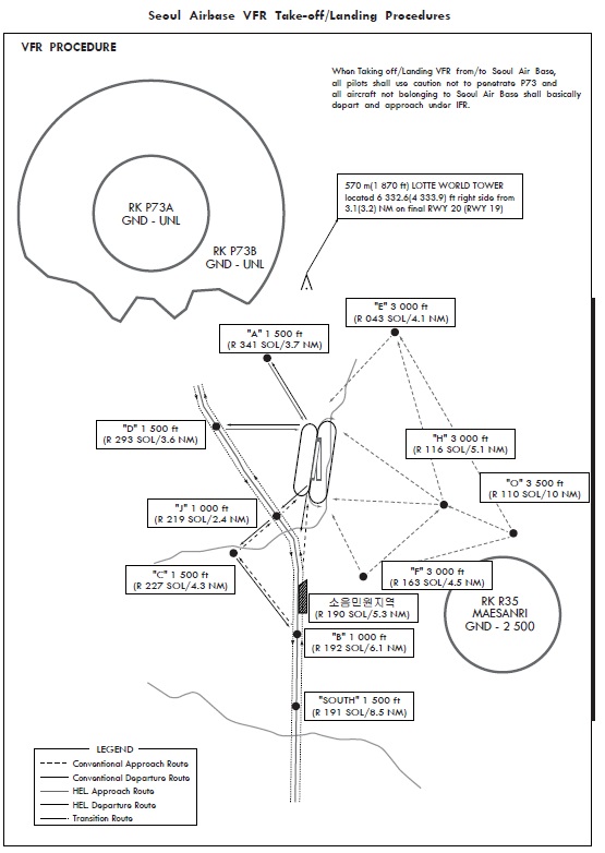
Aircrafts arriving in seoul airbase with VFR or passing through should contact with SEOUL APPROACH or SEOUL GCA outside of 15 NM from seoul airbase. Aircrafts should approach with permission of arrival and radar service support following VFR approach procedure. (except all foreign and civil aircraft)
-
Fixed-wing Aircraft
-
1) Approach from north and northeast to VRP(VFR report point) : Aircrafts should enter VRP("E/F/H" PT) via "O" PT. And aircrafts approaching from "E" or "F" PT via "O" PT should do Initial or Straight in approach.(RWY 20/19 : "E" PT, RWY 02/01 : "F" PT)
-
2) Approach from south, southeast and east to VRP : Aircrafts should enter east downwind via "H" PT. And aircrafts approaching from "E" or "F" PT via “H” PT should do Initial or Straight in approach. (RWY 20/19 : "E" PT, RWY 02/01 : "F" PT)
-
3) Approach from west to VRP
-
East pattern downwind 1 600 ft (B737 2 100 ft)
-
West pattern downwind 1 800 ft
Aircrafts should approach by IFR flight. When VFR approach is needed, approach via "E", "F" or "H" PT by Seoul APP Control.
※ Pattern altitude
-
-
Helicopters
1) Approaching from the North, Northeast or Northwest shall enter the West Traffic Pattern(Downwind 1 000 ft) after passing CP "A" through the P73 VFR Route Corridor.
2) Approaching from the South or Southwest shall enter the West Traffic Pattern(Downwind 1 000 ft) via IP "B" or CP "C" and CP "J" after initial contact at "SOUTH" point.
3) Approaching from the West shall enter the West Traffic Pattern(Downwind 1 000 ft) along Hyunheungro after passing CP "D".
4) When there are no Seoul Air Base flight missions(holiday or after completing flight on weekday), pilots who are intending to transit over noise complaints area shall fly at 2 000 ft after getting permission from the control tower if weather conditions are at or above flight visibility 3 SM/ceiling 2 500 ft.
3 VFR Departure Procedure
Fixed-wing aircraft shall depart under IFR basically. But if it is unable to do so, notify Control tower of the proposed departure route before take-off and then follow the VFR procedures under the support of RADAR Service by Seoul Approach Control.
-
For Fixed-wing Aircraft
Climb heading 0 23 °(When RWY 01/02 in use) or heading 190°(When RWY 19/20 in use) until reaching 1 000 ft (instrument altitude), then turn right and fly to the east until reaching 2 500 ft and then direct to the mission area.
-
Helicopters
-
1) When RWY 19/20 in use
When flying to the North, fly along the Geoungbu Expressway via CP "J". When flying to the South, fly along the Geoungbu Expressway at 1 000 ft or fly to IP "B" via CP "J" and CP "C".
-
2) When RWY 01/02 in use
When flying to the North, fly to CP "A" or CP "D". When flying to the South, fly along Downwind leg after take-off and then proceed to IP "B" via CP "B" and CP "J".
-
3) When there are no Seoul Air Base flight missions(holiday or after completing flight on weekday), pilots who are intending to transit over noise complaints area shall fly at 2 000 ft after getting permission from the control tower if weather conditions are at or above flight visibility 3 SM/ceiling 2 500 ft.
-
4 Control Zone Transition Procedure for Helicopters Using the Geoungbu Expressway
-
Transition from the south to the north
After initial contact at "SOUTH" point, fly along the Gyeongbu Expressway via IP "B", then report over CP "D" unless otherwise instructed by ATC to fly via CP "C" and CP "J".
-
Transition from the north to the south
After passing CP "D", fly along the Gyeongbu Expressway, then report over IP "B" unless otherwise instructed by ATC as fly via CP "C" and CP "J".
-
Avoidance of the noise complaints area.
When there are no Seoul Air Base flight missions(holiday or after completing flight on weekday), pilots who are intending to transit over noise complaints area shall fly at 2 000 ft after getting permission from the control tower if weather conditions are at or above flight visibility 3 SM/ceiling 2 500 ft.
5 Caution
-
When flying for SEOUL BASE Inbound (outbound), all pilots shall be careful of the LOTTE SUPER TOWER with the height* of 570 m AMSL(1 87 0 ft) which is located 6 332.6(4 333.9) ft right side from 3.1(3.2) NM on final RWY20(RWY19).
RKSM AD 2.23 ADDITIONAL INFORMATION
| NIL |
