RKTH — PoHang
RKTH AD 2.1 AERODROME LOCATION INDICATOR AND NAME
RKTH - POHANG/Domestic
RKTH AD 2.2 AERODROME GEOGRAPHICAL AND ADMINISTRATIVE DATA
|
1 |
ARP coordinates and site at AD |
355916N 1292507E 98° / 908 m from THR 10 |
|
2 |
Direction and distance from city |
125°, 8 km from Pohang City Hall |
|
3 |
Elevation/Reference temperature |
23 m / 30.5°C |
|
4 |
Geoid undulation at AD ELEV PSN |
29 m |
|
5 |
MAG VAR/Annual change |
8° W (2015) / 0.071˚ Increasing |
|
6 |
Aerodrome Operator, Address, Telephone, Telefax, AFS |
Post:
Pohang Airport Branch (Busan Regional Office of Aviation) Post:
18, Ilwol-ro, Donghae-myeon, Nam-gu, Pohang-si, Gyeongsangbuk-do, 37926 Republic of Korea Tel: Tel: +82-54-284-3456 Fax: Telefax: +82-54-285-4758 AFS: AFS: RKTHYFYX |
|
7 |
Types of traffic permitted (IFR/VFR) |
IFR/VFR |
|
8 |
Remarks |
NIL |
RKTH AD 2.3 OPERATIONAL HOURS
|
1 |
Aerodrome Operator |
2200-1300 UTC |
|
2 |
Customs and Immigration |
NIL |
|
3 |
Health and sanitation |
NIL |
|
4 |
AIS Briefing Office |
MON TO THU : 2230-0900 UTC FRI : 2230-1030 UTC SAT : 0000-0900 UTC SUN : 0000-1030 UTC |
|
5 |
ATS Reporting Office(ARO) |
MON TO THU : 2230-0900 UTC FRI : 2230-1030 UTC SAT : 0000-0900 UTC SUN : 0000-1030 UTC |
|
6 |
MET Briefing Office |
H24 |
|
7 |
ATS |
H24 |
|
8 |
Fuelling |
HO |
|
9 |
Handling |
HO |
|
10 |
Security |
HO |
|
11 |
De-icing |
HO |
|
12 |
Remarks |
NIL |
RKTH AD 2.4 HANDLING SERVICES AND FACILITIES
|
1 |
Cargo handling facilities |
NIL |
|
2 |
Fuel/oil types |
JP-8, 0-128(Available by agreement with ROKN) |
|
3 |
Fuelling facilities/capacity |
NIL |
|
4 |
De-icing facilities |
One de-icing pad(Aircraft stand 4) (See Aircraft Parking/Docking Chart) |
|
5 |
Hangar space for visiting aircraft |
NIL |
|
6 |
Repair facilities for visiting aircraft |
NIL |
|
7 |
Remarks |
NIL |
RKTH AD 2.5 PASSENGER FACILITIES
|
1 |
Hotels |
Hotel in Pohang city |
|
2 |
Restaurants |
Yes |
|
3 |
Transportation |
Buses, taxis, and rental cars |
|
4 |
Medical Facilities |
Hospitals in Pohang city, 11 KM |
|
5 |
Bank and Post Office |
NIL |
|
6 |
Tourist Office |
HO |
|
7 |
Remarks |
http://www.airport.co.kr/mbs/pohang/ |
RKTH AD 2.6 RESCUE AND FIRE FIGHTING SERVICES
|
1 |
AD Category for fire fighting |
Category 7 |
|
2 |
Rescue equipment |
|
|
3 |
Capability for removal of disabled aircraft |
Specialized aircraft recovery equipment available for up to and including B737-800 size aircraft. 270 ton crane and other accessory equipment can be provided by airlines and agencies. Korea Airports Corporation is the co-ordinator for the removal of disabled aircraft and can be reached at (Tel: +82-54-289-7312∼7317) Airport Duty Manager. |
|
4 |
Remarks |
NIL |
RKTH AD 2.7 SEASONAL AVAILABILITY - CLEARING
|
1 |
Type of clearing equipment |
|
|
2 |
Clearance priorities |
|
|
3 |
Remarks |
Snow clearance information promulgated by SNOWTAM * Republic of Korea Navy(ROKN) ** Korea Airport Corporation(KAC) |
RKTH AD 2.8 APRONS, TAXIWAYS AND CHECK LOCATIONS / POSITION DATA
|
1 |
Designation, Apron surface and strength |
|
|
2 |
Designation, Taxiway width, surface and strength |
|
|
3 |
Altimeter check location and elevation |
|
|
4 |
Location of VOR checkpoints |
NIL |
|
5 |
VOR/INS check points |
INS checkpoint : EV specified stands (Refer to Aircraft Parking & Docking chart) |
|
6 |
Remarks |
NIL |
RKTH AD 2.9 SURFACE MOVEMENT GUIDANCE AND CONTROL SYSTEM AND MARKINGS
|
1 |
Use of aircraft stand ID signs, TWY guide lines and visual docking/parking guidance system of aircraft stands |
|
|
2 |
RWY and TWY markings and LGT |
|
|
3 |
Stop bars |
NIL |
|
4 |
Remarks |
NIL |
RKTH AD 2.10 AERODROME OBSTACLES
|
In Area 2 | |||||
|
OBST ID/ Designation |
OBST type |
OBST position |
ELEV/HGT |
Markings/ Type, colour |
Remarks |
|
a |
b |
c |
d |
e |
f |
|
RKTHOB001 |
Hill |
355838.4N 1292314.8E |
315 ft/ |
NIL |
10 /APCH 28 /TKOF |
|
RKTHOB002 |
Pylon |
355855.9N 1292226.7E |
351 ft/ |
Marked/LGTD | |
|
RKTHOB003 |
Hill |
355808.6N 1291935.0E |
617 ft/ |
NIL | |
|
RKTHOB004 |
Hill |
355822.2N 1291909.0E |
753 ft/ |
NIL | |
|
RKTHOB005 |
Hill |
355917.0N 1291740.1E |
858 ft/ |
NIL | |
|
RKTHOB006 |
Mountain |
360909.1N 1291337.6E |
2 500 ft/ |
NIL | |
|
RKTHOB007 |
Hill |
355917.2N 1291740.8E |
844 ft/ |
NIL | |
|
RKTHOB008 |
Hill |
355915.6N 1292336.2E |
196 ft/ |
NIL | |
|
RKTHOB009 |
Hill |
355915.5N 1292327.4E |
217 ft/ |
NIL | |
|
RKTHOB010 |
Contour |
355803.2N 1292623.7E |
492 ft/ |
NIL |
In 10/28 circling area and at AD |
|
RKTHOB011 |
Hill |
355759.6N 1292623.9E |
534 ft/ |
NIL | |
|
RKTHOB012 |
Hill |
355857.1N 1292757.2E |
591 ft/ |
NIL | |
|
RKTHOB013 |
Antenna |
355840.1N 1292831.2E |
930 ft/34 ft |
Marked/LGTD |
28 /APCH 10 /TKOF 20:1 Obstacle identification surface(OIS) is penetrated by the obstacles (RKTHOB018,019,020 on final RWY 28 (Refer to AD CHART 2-6 Figure 1). |
|
RKTHOB014 |
VORTAC(KPO) |
355838.0N 1292828.3E |
929 ft/125 ft |
Marked/LGTD | |
|
RKTHOB015 |
Antenna |
355832.2N 1292822.3E |
841 ft/ |
Marked/LGTD | |
|
RKTHOB016 |
Antenna |
355833.5N 1292820.8E |
856 ft/ |
Marked/LGTD | |
|
RKTHOB017 |
Hill |
355929.1N 1292742.1E |
492 ft/ |
NIL | |
|
RKTHOB018 |
Hill |
355905.1N 1292831.4E |
663 ft/ |
NIL | |
|
RKTHOB019 |
Pylon |
355928.3N 1292742.1E |
540 ft/ |
Marked/LGTD | |
|
RKTHOB020 |
Pylon |
355932.2N 1292747.0E |
563 ft/ |
Marked/LGTD | |
|
RKTHOB021 |
Pylon |
355905.1N 1292831.4E |
722 ft/ |
Marked/LGTD | |
|
In Area 3 | |||||
|
OBST ID/ Designation |
OBST type |
OBST position |
ELEV/HGT |
Markings/ Type, colour |
Remarks |
|
a |
b |
c |
d |
e |
f |
|
RKTHOB022 |
Tree |
355909.8N 1292601.4E |
132.4 ft/94.4 ft |
NIL |
10 /APCH 28 /TKOF Obstacle RKTHOB022 is penetrating the transitional surface in the vicinity of the RWY 28 threshold. |
RKTH AD 2.11 METEOROLOGICAL INFORMATION PROVIDED
|
1 |
Associated MET Office |
Pohang Navy MET Office |
|
2 |
Hours of service MET Office outside hours |
24 hours - |
|
3 |
Office responsible for TAF preparation Periods of validity |
ROKN MET Office 30 hours at 0000, 0600, 1200, 1800 UTC |
|
4 |
Type forecast Interval of issuance |
Trend Type forecast (Gimhae Airport Weather Office) 1 hour (METAR) and when SPECI reported (ROKN MET Office) |
|
5 |
Briefing/consultation provided |
Available at Gimhae Airport Weather Office for 24 hours, if required |
|
6 |
Flight documentation Language(s) used |
AD forecasts(TAF code form), SIGWX charts, WINTEM charts, SIGMET information in English |
|
7 |
Charts and other information available for briefing or consultation |
Analysis charts(surface and upper air), Prognostic charts, Graphic displays and other model outputs |
|
8 |
Supplementary equipment available for providing information |
Satellite and Doppler weather radars imageries |
|
9 |
ATS units provided with information |
FIC and TWR |
|
10 |
Additional informaton(limitation of service, etc.) |
All observation data, model outputs and forecasts produced by KMA and WAFS are available at the Office through Internet link. |
RKTH AD 2.12 RUNWAY PHYSICAL CHARACTERISTICS
|
Designations Runway NR |
TRUE BRG |
Dimension of RWY(M) |
Strength(PCN) and surface of RWY and SWY |
THR coordinates RWY end coordinates THR geoid undulation |
THR elevation and highest elevation of TDZ of precision APP RWY |
|---|---|---|---|---|---|
|
1 |
2 |
3 |
4 |
5 |
6 |
|
10 |
089.23 ° |
2 133 × 46 M |
49/R/B/W/T Concrete |
355916.12 N 1292430.75 E |
THR 23 M / 7 5 FT |
|
28 |
269.25 ° |
2 133 × 46 M |
49/R/B/W/T Concrete |
355917.04 N 1292555.91 E |
THR 1 9 M / 6 1 FT |
|
7. Slope of RWY-SWY | |||||
 | |||||
|
SWY dimensions(M) |
CWY dimensions(M) |
Strip dimensions(M) |
RESA dimension(m) |
Location & description of arresting system |
OFZ |
Remarks | |
|---|---|---|---|---|---|---|---|
|
8 |
9 |
10 |
11 |
12 |
1 3 |
1 4 | |
|
NIL |
NIL |
2 253 x 300 |
92 x 150 |
NIL |
NIL |
- The width of the southern strip is 139~145 M, from the western edge of the strip to 90 M. - The width of the northern strip is 134~141 M, from theeastern edge of the strip to 198 M - The runway surface is grooved except 300 M inward from each runway threshold, and an additional 300 M of runway centerline 15.24 M in width | |
|
NIL |
NIL |
2 253 x 300 |
92 x 150 |
NIL |
NIL | ||
RKTH AD 2.13 DECLARED DISTANCES
|
RWY Designator |
TORA (M) |
TODA (M) |
ASDA (M) |
LDA (M) |
Remarks |
|---|---|---|---|---|---|
|
1 |
2 |
3 |
4 |
5 |
6 |
|
10 |
2 133 |
2 133 |
2 133 |
2 133 |
NIL |
|
28 |
2 133 |
2 133 |
2 133 |
2 133 |
NIL |
RKTH AD 2.14 APPROACH AND RUNWAY LIGHTING
|
RWY Designator |
APCH LGT type LEN INTST |
THR LGT Colour WBAR |
VASIS (MEHT) PAPI |
TDZ LGT LEN |
RWY Center line LGT Length, Spacing, colour,INTST |
RWY edge LGT LEN,Spacing colour INTST |
RWY End LGT colour WBAR |
SWY LGT LEN(M) colour |
|---|---|---|---|---|---|---|---|---|
|
1 |
2 |
3 |
4 |
5 |
6 |
7 |
8 |
9 |
|
10 |
ALSF-1 720 M LIH |
Green |
PAPI Both/3. 0 ˚ |
NIL |
NIL |
2 134 M 60 M White LIH |
Red |
NIL |
|
28 |
SSALF 420 M |
Green |
PAPI Both/3.5˚ |
NIL |
NIL |
2 134 M 60 M White LIH |
Red |
NIL |
|
10. Remarks PAPI on RWY 28 does not provide obstacle clearance over the terrain during final APCH. | ||||||||
RKTH AD 2.15 OTHER LIGHTING, SECONDARY POWER SUPPLY
|
1 |
ABN/IBN location, characteristics and hours of operation |
ABN: At TWR building, FLG W/G EV 2.5 SEC /IBN: NIL H24 |
|
2 |
LDI location and LGT Anemometer location and LGT |
NIL |
|
3 |
TWY edge and center line lighting |
Edge : All TWY Center line LGT : NIL |
|
4 |
Secondary power supply/swithch-over time |
SRY power supply available Switch-over time: 10 SEC |
|
5 |
Remarks |
NIL |
RKTH AD 2.16 HELICOPTER LANDING AREA
|
1 |
Coordinates TLOF or THR of FATO Geoid undulation |
To be developed |
|
2 |
TLOF and/or FATO elevation M/FT |
- |
|
3 |
TLOF and FATO area dimensions, surface, strength, marking |
- |
|
4 |
True BRG of FATO |
- |
|
5 |
Declared distance available |
- |
|
6 |
APP and FATO lightng |
- |
|
7 |
Remarks |
As directed by ATC. |
RKTH AD 2.17 ATS AIRSPACE
|
1 |
Designation and lateral limit |
Pohang CTR A circle, radius 5 NM centered at ARP |
|
2 |
Vertical limits |
SFC to 3 000 FT AGL |
|
3 |
Airspace classification |
C |
|
4 |
ATS unit call sign Languages |
Pohang Tower English / Korean |
|
5 |
Transition altitude |
14 000 FT AMSL |
|
6 |
Operational hours |
H24 |
|
7 |
Remarks |
NIL |
RKTH AD 2.18 COMMUNICATION FACILITIES
|
Service designation |
Call sign |
Channel |
Hours of operation |
Remarks |
|---|---|---|---|---|
|
1 |
2 |
3 |
4 |
5 |
|
APP |
Pohang Approach |
124.25 MHz 120.2 MHz 232.4 MHz |
H24 |
NIL |
|
TWR |
Pohang Tower |
118.05 MHz 236.6 MHz 334.6 MHz |
H24 |
NIL |
|
GND |
Pohang Ground |
126.2 MHz 275.8 MHz |
H24 |
NIL |
|
ATIS |
Pohang Airport |
127.4 MHz 317.375 MHz |
2100 - 1200 UTC |
NIL |
|
EMERG |
121.5 MHz 243.0 MHz |
H24 |
NIL | |
|
Scheduled Inspection time :
- APP(124.25 MHz), TWR(118.05 MHz) and ATIS : Every
| ||||
RKTH AD 2.19 RADIO NAVIGATION AND LANDING AIDS
|
Type of aid, null |
ID |
Frequency |
Hours of operation |
Position of transmitting antenna coordinates |
Elevation of DME transmitting antenna |
Remarks | ||||
|---|---|---|---|---|---|---|---|---|---|---|
|
1 |
2 |
3 |
4 |
5 |
6 |
7 | ||||
|
VORTAC (8°W/2015) |
NPH |
109.6 MHz (CH 33X) |
H24 |
355910.9N 1292431.8 E |
- |
SKED Inspection time: · Every 1st TUE(1300-1700UTC) of the month - VORTAC(NPH) · Every 3rd TUE(1300-1700UTC) of the month - LOC - DME · Every 2nd THU(1300-1700UTC) of the month - VORTAC(KPO) | ||||
|
VORTAC (8°W/2015) |
KPO |
112.5 MHz (CH 72X) |
H24 |
355837.9N 1292828.3E |
- | |||||
|
LOC 10 (8°W/2015) |
IKPO |
110.9 MHz (CH 46X) |
H24 |
355917.1N 1292602.4E |
- | |||||
|
DME 10 |
IKPO |
1007 MHz (TX) 1070 MHz (RX) |
H24 |
355915.7N 1292604.2E |
30 M | |||||
|
PAR |
9.3 GHz 9.42 GHz |
H24 |
355920.2N 1292510.6E |
- |
SKED Inspection time
· Every
| |||||
|
※ VORTAC(NPH) unusable area
| ||||||||||
RKTH AD 2.20 LOCAL AERODROME REGULATIONS
1 Aircraft operation is restricted when surface measurement is less than 0.25 due to shortage of clearway.
2 When obstacle ①, ② and ③(see AD 2.10; Aerodrome obstacles) are not lighted at night(from sunset to sunrise), VOR/DME RWY 28 Approach(both straight-in and circling) is NOT authorized.
3 Establishment of temporal restricted area
All aircrafts must avoid flying over POSCO as follows :
|
Period |
Vertical limit |
Lateral limit |
|
Until Complete Construction of RUNWAY |
6 000 FT AMSL/SFC |
360219N1292404E-360157N1292524E- 360136N1292500E-360146N1292430E- 360117N1292401E-360114N1292346E- 360043N1292327E-360037N1292339E- 360049N1292359E-360031N1292426E- 360039N1292434E-360042N1292521E- 355947N1292406E-355936N1292401E- 355932N1292347E-360036N1292229E- 360141N1292306E TO THE BEGINNING |
RKTH AD 2.21 NOISE ABATEMENT PROCEDURES
|
NIL |
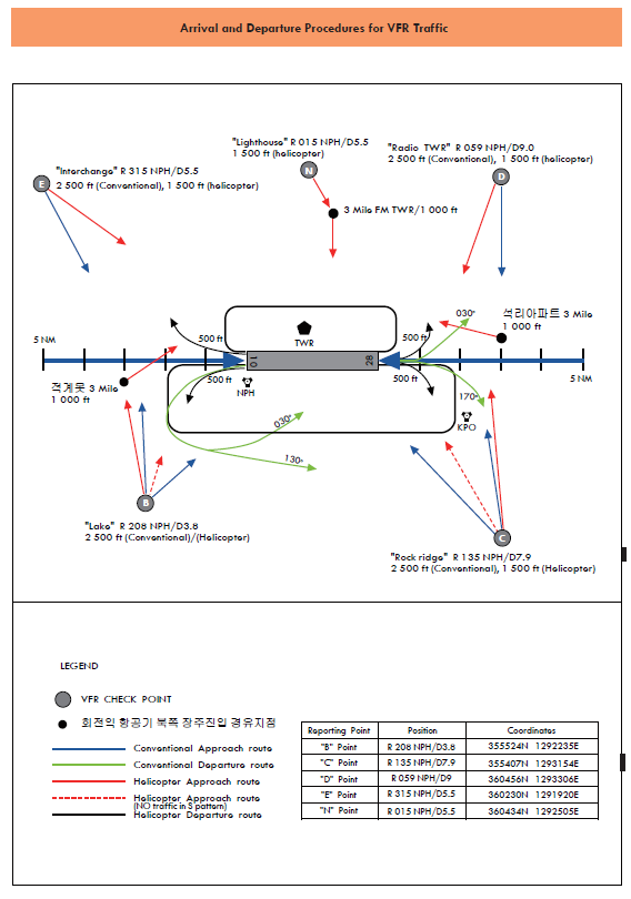
RKTH AD 2.22 FLIGHT PROCEDURES
1 RADAR Procedures
-
RWY 10
1) Weather minima
CAT
GS/TCH/RPI
DA(MDA)-VIS
HAT/HAA
Ceiling
FULL
A,B,C,D
3° / 5 6 ft / 1 126.84 ft
463 ft / ³/₄
387 ft
4 00 ft
E
NA
NA
NA
NA
ALS
INOP
A,B,C,D
3° / 5 6 ft / 1 126.84 ft
463 ft / 1 ¼
387 ft
4 00 ft
E
NA
NA
NA
NA
* Remarks : Missed approach requires minimum climb of 360 f t per NM to 5 100 ft .
2) Missed approach procedure
Climb to 5 0 00 ft via heading 097° to NPH VORTAC 2 DME and climbing left turn heading 030°, then directed null by ATC.
Alternate Missed approach : Climb to 5 0 00 ft via heading 097° , then directed by ATC.
-
RWY 28
1) Weather minima
CAT
GS/TCH/RPI
DA(MDA)-VIS
HAT/HAA
Ceiling
FULL
A,B
3.8° / 60 ft / 866.61 ft
1 306 ft / 3
1 237 ft
1 300 ft
C,D, E
NA
NA
NA
NA
ALS
INOP
A,B
3.8° / 60 ft / 866.61 ft
1 306 ft / 3
1 237 ft
1 300 ft
C,D, E
NA
NA
NA
NA
* Remarks : PAPI and procedure TCH is not coincident.(VGSI angle 3.5° / TCH 86)
2) Missed approach procedure
AT DH, Climb to 5 000 ft Via heading 277°, then as directed by ATC.
-
RWY 10
1) Weather minima
CAT
A
B
C
D
FULL
600 / 40
524 (600- ³/₄)
600 / 40
524 (600- ³/₄)
600 / 55
524 (600-1)
600 / 55
524 (600-1)
ALS INOP
600 / 55
524 (600-1)
600 / 55
524 (600-1)
600 / 1¹/₂
524 (600-1¹/₂)
600 / 1¹/₂
524 (600-1¹/₂)
CIRCLING
940 / 1¹/₄
864 (900-1¹/₄)
1 000 / 1¹/₄
924 (1000-1¹/₄)
1 240 / 3
1 164 (1200-3)
14 600 / 3
1 384 (1400-3)
2) Missed approach procedure
Climb to 5 100 ft via heading 097º to NPH VORTAC 2 DME and climbing left turn heading 030º, then directed by ATC.
Alternate Missed approach : Climb to 5 100 ft via heading 097º, then directed by ATC.
-
RWY 28
1) Weather minima
CAT
A
B
C
D
FULL
1 180 / 55
1111 (1200-1)
1 180 / 60
1 111 (1200-1¼)
1 180 / 3
1 111(1200-3)
1180 / 3
1 111(1200-3)
ALS INOP
1 180 / 55
1 111 (1200-1)
1 180 / 60
1 111 (1200-1¼)
1180 / 3
1 111(1200-3)
1180 / 3
1 111(1200-3)
CIRCLING
1 180 / 1¼
1 104 (1200-1¼)
1 180 / 1¹/₂
1 104 (1200-1¹/₂)
1 240 / 3
1 164(1200-3)
1 460 / 3
1 384(1400-3)
2) Missed approach procedure
Climb to 5 100 ft Via heading 277°, Then directed by ATC.
If no transmissions are received for 1 minute in the pattern or 5sec(PAR) / 15sec(ASR) on final approach, attempt contact TWR(334.6 MHz or 118.05 MHz) and proceed VFR. If unable, proceed with LOC/DME RWY 10 approach, maintain 5 000 FT until establish on approach procedure.
2 Take-off weather minima
|
ENG |
RWY 10 |
RWY 28 |
|
1, 2 |
1 600 M |
1 600 M |
|
3, 4 |
800 M |
800 M |
3 COMMUNICATION FAILURE
-
General
-
No person may take off unless two-way communication can be maintained with the Air Traffic Control.
-
On recognition of communication failure during flight, squawk 7600 and if necessary to ensure safe altitude, climb to Minimum Safe Altitude or above to maintain obstacle clearance. Then comply with following Procedures. Then comply with following procedure.
-
-
VFR condition
If the failure occurs in VFR conditions, or if VFR conditions are encountered after the failure, each pilot shall continue the flight under VFR and land as soon as practicable.
-
IFR condition
If the failure occurs in IFR conditions, or if paragraph 2 of this section cannot be complied with, each pilot shall continue the flight according to the following:
-
DEPARTURE
-
Under Pilot Navigation
- Runway 10 in use
-
ALL AIRCRAFT : DEPARTURE CLIMB RATE 490 ft/nm TO 5 100 TURN MAX SPEED 250 kt IAS TAKE-OFF AT LEAST 35 ft AGL OVER DER
TAKE-OFF RWY 10 : Climb heading 097º to NPH 4 DME or cross KPO LR-057, then via assigned transition routes
The following transitions are ATC assigned only : Fly to intercept for en route.
ELAPI Transition : ........left turn HDG 280º to intercept R 314 KPO and R 314 KPO to ELAPI.
LOSTO Transition : ........left turn HDG 330º to intercept R 002 KPO and R 002 KPO to LOSTO.
BULGA Transition : ........right turn HDG 130º to intercept R 106 KPO and R 106 KPO to BULGA.
APARU Transition : ........right turn HDG 240º to intercept R 212 KPO and R 212 KPO to APARU.
LAPAL Transition : ........right turn HDG 300º to intercept R 265 KPO and R 265 KPO to LAPAL.
- Runway 28 in use
-
ALL AIRCRAFT : DEPARTURE CLIMB RATE 47 0 ft/ NM TO 5 100 TURN MAX SPEED 250 kt IAS TAKE-OFF AT LEAST 35 ft AGL OVER DER
TAKE-OFF RWY 28 : Climb heading 277º to NPH 4DME or cross KPO LR-282, then via assigned transition routes
The following transitions are ATC assigned only : Fly to intercept for en route.
ELAPI Transition : ........right turn HDG 340º to intercept R 314 KPO and R 314 KPO to ELAPI.
LOSTO Transition : ........right turn HDG 080º to intercept R 106 KPO and R 106 KPO to BULGA.
APARU Transition : ........left turn HDG 170º to intercept R 212 KPO and R 212 KPO to APARU.
LAPAL Transition : ........left turn HDG 240º to intercept R 265 KPO and R 265 KPO to LAPAL.
-
-
-
ARRIVAL
- Runway 10 in use
-
If the failure occurs proceed with LOC/DME procedure, maintain 5 000 FT until establish on approach procedure.
- Runway 28 in use
-
If the failure occurs proceed with VOR/DME procedure, maintain 6 000 FT until establish on approach procedure.
-
-
-
VFR flight which has encountered radio communication failure shall
-
Helicopter
1) Squawk 7600, and
2) When able to see light gun signal from control tower, follow that instruction.
3) If unable to see light gun signal from control tower, hold over " N " until ETA or for 10minutes, whichever is later, then
4) Land parallel taxi way as appropriate
-
Conventional flight
1) Squawk 7600, and
2) When able to see light gun signal from control tower, follow that instruction.
3) If unable to see light gun signal from control tower, hold over " N " until ETA or for 10 minutes, whichever is later, then
4) Make landing on runway 10/28 in use as appropriate.
-
RKTH AD 2.23 ADDITIONAL INFORMATION
-
Bird concentrations in the vicinity of airport
An average of 14 000 birds a year have been flown around Pohang Airport.
It is shown the increasing number of birds when the groups of snipes and skylarks start plying the action in April, May, September, October and November.
Usually, sedentary birds fly over during the time of sunrise and sunset around the year except late spring and fall. The status of flying on each period is as follows. In January and February, the groups of gulls fly over (200 FT) the Pohang airport to move to Hodong landfill from Dogu coast during the time of sunrise and sunset.
In April and May, the groups of snipes inhabit at the airport and fly around the area. In August and September, a number of sparrow hawk fly over Pohang Airport and the groups of skylarks are active in October and September.
It is indicated that the groups of birds are on the feed surrounding taxiway at Pohang Airport, Then, they do not fly across the runway and fly back to their habitat close to the outskirts of the airport. However, the groups of skylarks and snipes, which are active late spring and in fall, are on the feed as well as inhabit within the airport.
