RKTU — Cheongju
RKTU AD 2.1 AERODROME LOCATION INDICATOR AND NAME
RKTU - CHEONGJU / International
RKTU AD 2.2 AERODROME GEOGRAPHICAL AND ADMINISTRATIVE DATA
|
1 |
ARP coordinates and site at AD |
36˚42'59"N 127˚29'57"E 235° / 1 441 m from THR 24R |
|
2 |
Direction and distance from city |
022°, 8.1 km from Cheongju City Hall |
|
3 |
Elevation/Reference temperature |
58 m (192 ft) / 30.4°C |
|
4 |
Geoid undulation at AD ELEV PSN |
25 m |
|
5 |
MAG VAR/Annual change |
8°W (2010) / 0.033° increasing |
|
6 |
Aerodrome Operator, Address, Telephone, Telefax, AFS |
Post:
ROKAF Cheongju Airport Office (Seoul Regional Aviation Administration) Post:
980, Ochang-daero, Neasu-eup, Cheongwon-gun, Chungcheongbuk-do 28142, Republic of Korea Tel: Tel : +82-43-210-6202,3 Fax: Telefax : +82-43-213-6105 AFS: AFS : RKTUZPZX |
|
7 |
Types of traffic permitted(IFR/VFR) |
IFR / VFR |
|
8 |
Remarks |
NIL |
RKTU AD 2.3 OPERATIONAL HOURS
|
1 |
Aerodrome Operator |
H24 |
|
2 |
Customs and Immigration |
HO |
|
3 |
Health and Sanitation |
HO |
|
4 |
AIS Briefing Office |
H24 |
|
5 |
ATS Reporting Office |
H24 |
|
6 |
MET Briefing Office |
H24 |
|
7 |
ATS |
H24 |
|
8 |
Fuelling |
H24 |
|
9 |
Handling |
HO |
|
10 |
Security |
HO |
|
11 |
De-icing |
H24 |
|
12 |
Remarks |
- |
RKTU AD 2.4 HANDLING SERVICES AND FACILITIES
|
1 |
Cargo handling facilities |
Modern facilities |
|
2 |
Fuel/oil types |
Jet A-1 / Turbo 2380 |
|
3 |
Fuelling facilities/capacity |
No limitations at any time service available |
|
4 |
De-icing facilities |
Available. Location of de-icing pad : 7, 8 behind Taxi line |
|
5 |
Hangar space for visiting aircraft |
Not available |
|
6 |
Repair facilities for visiting aircraft |
Not available |
|
7 |
Remarks |
NIL |
RKTU AD 2.5 PASSENGER FACILITIES
|
1 |
Hotels |
Near the AD and in the city. |
|
2 |
Restaurants |
40 seats, light food service available. |
|
3 |
Transportation |
Buses, Taxis, Train from the AD. |
|
4 |
Medical Facilities |
a. Ambulance service available. b. Hospitals in Cheongju city, 7 km |
|
5 |
Bank and Post Office |
Bank available at airport. |
|
6 |
Tourist Office |
Available at airport. |
|
7 |
Remarks |
www.airport.co.kr/mbs/cheongju |
RKTU AD 2.6 RESCUE AND FIRE FIGHTING SERVICES
|
1 |
AD Category for fire fighting |
CAT 8 |
|
2 |
Rescue equipment |
|
|
3 |
Capability for removal of disabled aircraft |
|
|
4 |
Remarks |
NIL |
RKTU AD 2.7 SEASONAL AVAILABILITY-CLEARING
|
1 |
Type of clearing equipment |
Serviced by ROKAF and KAC * ROKAF :
** KAC :
|
|
2 |
Clearance priorities |
|
|
3 |
Remarks |
Snow clearance information promulgated by SNOWTAM. * Republic of Korea Air Force(ROKAF) ** Korea Airports Corporation(KAC) |
RKTU AD 2.8 APRONS, TAXIWAYS AND CHECK LOCATIONS / POSITION DATA
|
1 |
Designation, Apron surface and strength |
Surface : Concrete. Strength : PCN 85/R/B/W/T - Stand 1~8, 10, 11, 91~98 | ||||
|
2 |
Designation, Taxiway width, surface and strength |
| ||||
|
3 |
Altimeter checkpoint location and elevation |
All Aprons : 52 m | ||||
|
4 |
VOR checkpoints |
VOR : NIL | ||||
|
5 |
INS checkpoints |
INS : See Aircraft Parking/Docking Chart | ||||
|
6 |
Remarks |
NIL |
RKTU AD 2.9 SURFACE MOVEMENT GUIDANCE AND CONTROL SYSTEM AND MARKINGS
|
1 |
Use of aircraft stand ID signs, TWY guide lines and visual docking/parking guidance system of aircraft stands |
Taxing guidance signs at all intersections with TWY and RWY and holding position, Guide lines at apron Nose-in guidance at aircraft stands. |
|
2 |
RWY and TWY markings and LGTs |
a. RWY 1) Lights - RWY 06L - Edge, THR, end - RWY 24R - Edge, THR, end 2) Markings - RWY 06L : Designation, THR, TDZ, Center Line,Side Stripe,Aiming point marked - RWY 24R : Designation, THR, TDZ, Center Line,Side Stripe,Aiming point marked b. TWY 1) Lights - TWY edge lights : All TWY 2) Marking - TWY & taxilane centerlne marked - Holding position at TWY/RWY, intersections markded |
|
3 |
Stop bars |
NIL |
|
4 |
Remarks |
NIL |
RKTU AD 2.10 AERODROME OBSTACLES
|
In Approach/TKOF areas |
In circling area and at AD |
Remarks | ||||
|---|---|---|---|---|---|---|
|
1 |
2 |
3 | ||||
|
RWY/Area affected |
Obstacle type Elevation Marking/LGT |
Coordinates |
Obstacle type Elevation Markings/LGT |
Coordinates | ||
|
a |
b |
c |
a |
b | ||
|
24R/APCH 06L/TKOF |
Mt. Dutae (595 m) |
Northeast(031°) 6.5 NM from the ARP |
KBS Antena 84 m Red LGT |
Northwest 1.5 NM from the Airport |
<Caution> Arresting gears are installed: -BAK-12(on the RWY) -Barriers(on the overrunway) -RSU(RWY Supervisor Unit)s are installed in the east side of RWY 06R/24L. | |
|
- |
- |
Mountain (Dutae) 595 m(1 962 ft) |
Northeast 6.5 NM from the AD | |||
|
24L/APCH 06R/TKOF |
Mt. Bokwang (532 m) |
Northeast(062°) 10.6 NM from the Airport ARP | ||||
RKTU AD 2.11 METEOROLOGICAL INFORMATION PROVIDED
|
1 |
Associated MET Office |
Cheongju Airforce MET Office |
|
2 |
Hours of service MET Office outside hours |
24 hours |
|
3 |
Office responsible for TAF preparation Periods of validity |
ROKAF MET Office 30 hours at 0000, 0600, 1200, 1800 UTC |
|
4 |
Trend forecast Interval of issuance |
Trend Type forecast (Gimhae Airport Weather Office) 1 hour (METAR) and when SPECI reported (ROKAF MET Office) |
|
5 |
Briefing/consultation provided |
Available at Gimhae Airport Weather Office for 24 hours, if required |
|
6 |
Flight documentation language(s) used |
Aerodrome forecasts(TAF code form), SIGWX charts, WINTEM charts, SIGMET information in English. |
|
7 |
Charts and other information available for briefing or consultation |
Analysis charts(surface and upper air), Prognostic charts, Graphic displays and other model outputs |
|
8 |
Supplementary equipment available for providing information |
Satellite and weather radar imageries |
|
9 |
ATS units provided with information |
FIC and TWR |
|
10 |
Additional informaton (limitation of service, etc.) |
All observation data, model outputs and forecasts produced by KMA and WAFS are available at the office through internet link |
RKTU AD 2.12 RUNWAY PHYSICAL CHARACTERISTICS
|
Designations RWY NR |
TRUE BRG |
Dimension of RWY(M) |
Strength(PCN) and surface of RWY and SWY |
THR coordinates RWY end coordinates THR geoid undulation |
THR elevation and highest elevation of TDZ of precision APP RWY |
|---|---|---|---|---|---|
|
1 |
2 |
3 |
4 |
5 |
6 |
|
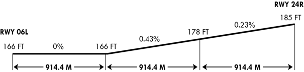
06L |
052.42 ° |
2 744 × 60 |
85/R/B/W/T Concrete |
364236.10 N 1272912.46 E - GUND 24.9 M |
THR 50.6 M / 166 FT TDZ 50.5 M / 166 FT |
|
24R |
232.43 ° |
2 744 × 60 |
85/R/B/W/T Concrete |
364330.38 N 1273040.05 E - GUND 25.0 M |
THR 56.5 M / 185 FT TDZ 55.5 M / 182 FT |
|
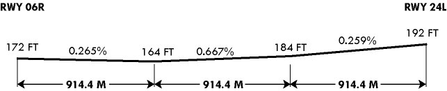
06R |
052.42 ° |
2 744 × 45 |
34/R/B/W/T |
364228.26 N 1272914.84 E GUND 25.0 M |
THR 52.4 M / 172 FT TDZ 51.5 M / 168 FT |
|
24L |
232.43 ° |
2 744 × 45 |
34/R/B/W/T |
364322.52 N 1273042.46 E GUND 25.0 M |
THR 58.5 M / 192 FT TDZ 57.6 M / 189 FT |
|
7. Slope of RWY-SWY | |||||
  | |||||
|
SWY dimensions |
CWY dimensions |
Strip dimensions(M) |
OFZ |
Remarks | |
|---|---|---|---|---|---|
|
8 |
9 |
10 |
11 |
12 | |
|
- |
- |
2 864 × 300 |
- |
· ACFT arresting system are installed at each RWY THR · The surface of RWY 06L/24R are grooved (Except 300 M inward from each THR RWY 06L/24R) | |
|
- |
- |
2 864 × 300 |
- | ||
|
- |
- |
2 864 × 300 |
- |
· ACFT arresting system are installed at each RWY THR · The surface of RWY 06R/24L are groove | |
|
- |
- |
2 864 × 300 |
- | ||
RKTU AD 2.13 DECLARED DISTANCES
|
RWY Designator |
Intersection Point |
TORA (M) |
TODA (M) |
ASDA (M) |
LDA (M) |
Remarks |
|---|---|---|---|---|---|---|
|
1 |
2 |
3 |
4 |
5 |
6 |
7 |
|
06L |
End of RWY |
2 744 |
2 744 |
2 744 |
2 744 |
Barrier(MA-1A MOD/1.7 M) - End of RWY |
|
A3 |
744 |
744 |
744 |
744 | ||
|
B3 |
1 348 |
1 348 |
1 348 |
1 348 | ||
|
24R |
End of RWY |
2 744 |
2 744 |
2 744 |
2 744 | |
|
A3 |
2 000 |
2 000 |
2 000 |
2 000 | ||
|
B3 |
1 395 |
1 395 |
1 395 |
1 395 |
RKTU AD 2.14 APPROACH AND RUNWAY LIGHTING
|
RWY Designator |
APCH LGT type LEN INTST |
THR LGT Color WBAR |
VASIS (MEHT) PAPI |
TDZ,LGT LEN |
RWY Center Line LGT LEN, Spacing Colour, INTST |
RWY edge LGT LEN Spacing Colour INTST |
RWY End LGT Color WBAR |
SWY LGT LEN(M) Color |
REMARKS |
|---|---|---|---|---|---|---|---|---|---|
|
1 |
2 |
3 |
4 |
5 |
6 |
7 |
8 |
9 |
10 |
|
06L |
SSALS 720 M LIH |
Green Green |
PAPI Both/3° (57.7FT) |
NIL |
NIL |
2 744 M 60 M White, LIH |
Red - |
NIL |
NIL |
|
24R |
ALSF-I 900 M LIH |
Green Green |
PAPI Both/3° (57.7FT) |
NIL |
NIL |
2 744 M 60 M White, LIH |
Red - |
NIL | |
|
06R |
NIL |
Green |
PAPI Both/3° (50FT) |
NIL |
NIL |
2 744 M 45 M White, LIH |
Red |
NIL |
NIL |
|
24L |
ALSF-I 900 M LIH |
Green |
PAPI Both/3° (50FT) |
NIL |
NIL |
2 744 M 45 M White, LIH |
Red |
NIL |
NIL |
RKTU AD 2.15 OTHER LIGHTING, SECONDARY POWER SUPPLY
|
1 |
ABN/IBN location, characteristics and hours of operation |
ABN : At ROKAF hangar building, Flg W&G EV 2.5sec H24 IBN : NIL |
|
2 |
LDI location and LGT Anemometer location and LGT |
NIL Anemometer : 469 M from RWY 24R THR and LGT |
|
3 |
TWY edge and center line lighting |
Edge : TWY of Civil Aviation at RWY 06L - 24R TWY Centre line lights : NIL |
|
4 |
Secondary power supply/swithch-over time |
Secondary power supply to all lighting at RWY06L-24R Switch-over time : 10sec |
|
5 |
Remarks |
NIL |
RKTU AD 2.16 HELICOPTER LANDING AREA
|
1 |
Coordinates TLOF or THR of FATO Geoid undulation |
- |
|
2 |
TLOF and/or FATO elevation M/FT |
- |
|
3 |
TLOF and FATO area dimesions, surface, strength and marking |
- |
|
4 |
True BRG of FATO |
- |
|
5 |
Declared distance available |
- |
|
6 |
APP and FATO lightng |
- |
|
7 |
Remarks |
As directed by ATC. |
RKTU AD 2.17 ATS AIRSPACE
|
1 |
Designation and lateral limit |
Cheongju CTR A circle, 5 NM radius centered at ARP |
|
2 |
Vertical limits |
SFC to 5 000 ft AGL |
|
3 |
Airspace classification |
Class D |
|
4 |
ATS unit call sign Languages |
CHEONGJU TOWER Korean and English |
|
5 |
Transition altitude | 14 000 ft AMSL |
|
6 |
Operational Hours |
H24 |
|
7 |
Remarks |
NIL |
RKTU AD 2.18 ATS COMMUNICATION FACILITIES
|
Service designation |
Call sign |
Channel |
Hours of operation |
Remarks |
|---|---|---|---|---|
|
1 |
2 |
3 |
4 |
5 |
|
APP |
Jungwon Approach/Departure |
134.4 MHz 134.1 MHz 134.0 MHz |
H24 | |
|
TWR |
Cheongju Tower |
118.7 MHz* 126.2 MHz |
H24 | |
|
GND |
Cheongju Ground |
121.875 MHz** |
H24 | |
|
ATIS |
Cheongju INTL Airport |
128.85 MHz 305.5 MHz |
H24 | |
|
EMERG |
121.5 H24 243.0 H24 |
H24 | ||
|
Scheduled Inspection Time - * : Every 3rd THU(1400-1900UTC) of the month. - ** : Every 3rd THU(1400-1900UTC) of the month. | ||||
RKTU AD 2.19 RADIO NAVIGATION AND LANDING AIDS
|
Type of aid, MAG VAR Type of supported OPS |
ID |
Frequency |
Hours of operation |
Position of transmitting antenna coordinates |
Elevation of DME transmitting antenna |
Remarks |
|---|---|---|---|---|---|---|
|
1 |
2 |
3 |
4 |
5 |
6 |
7 |
|
VOR/DME |
CHO |
109.0 MHz / 988 MHz (CH27X) |
H24 |
364304.9N 1272938.7E |
90 m |
Scheduled Inspection Time Every 4th THU(1400-2000 UTC) of the month VOR/DME Unusable - VOR · Radial 20 Clockwise Radial 40 beyond 14NM, below 5 500 ft · Radial 120 Clockwise Radial 160 beyond 20NM, below 7 000 ft - DME · Radial 20 Clockwise Radial 40 beyond 14NM, below 5 500 ft · Radial 120 Clockwise Radial 160 beyond 20NM, below 7 000 ft |
|
LOC 24R |
ICHG |
111.7 MHz (CH54X) |
H24 |
364230.0N 1272902.6E |
Scheduled Inspection Time Every 2nd THU(1400-2000 UTC) of the month | |
|
GP 24R | 333.5 MHz |
H24 |
364327.4N 1273027.7E | |||
|
DME 24R |
ICHG |
(T) 1015 MHz (R) 1078 MHz (CH54X) |
H24 |
364327.4N 1273027.7E |
90 m | |
|
LOC 06L |
ICHJ |
110.3 MHz (CH40X) |
H24 |
364336.6N 1273050.1E | ||
|
GP 06L |
333.5 MHz |
H24 |
364239.6N 1272924.6E | |||
|
DME 06L |
ICHJ |
(T) 1001 MHz (R) 1064 MHz (CH40X) |
H24 |
364239.4N 1272924.7E |
90 m |
RKTU AD 2.20 LOCAL AERODROME REGULATIONS
1 ICAO code letter "F" aircraft procedures for the usage of the alternate airport, RKTU
-
Departure
RWY 24R : NR 11 → A3 → 24R RWY turn pads → 24R RWY threshold
RWY 06L : NR 11 → A3 → 06L RWY turn pads → 06L RWY threshold
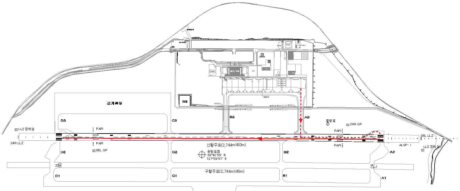
RWY 24R(Departure)
RWY 06L(Departure)
-
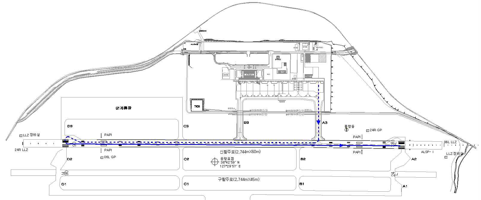
Arrival
RWY 24R : 24R RWY Threshold → 06L RWY turn pads → A3 → NR 11
RWY 06L : 06L RWY Threshold → 24R RWY turn pads → A3 → NR 11

RWY 24R(Arrival)
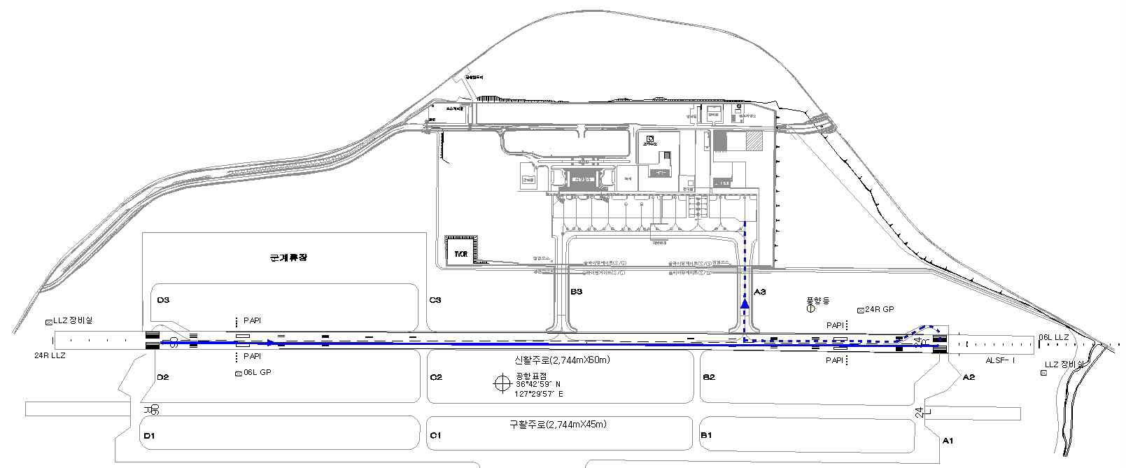
RWY 06R(Arrival)
- ICAO code letter “F” aircraft are not able to take-off or land on RWY 06R/24L.
- ICAO code letter “F” aircraft shall enter the apron via A3 TWY and shall not move via B3 TWY.
- After take off or landing of ICAO code letter “F” aircraft, take-off or landing of any other aircraft should be prohibited on RWY 06L/24R until RWY checking and removing FOD are finished.
-
Aircraft TOW and LDW for the usage of the alternate airport shall be restricted as follows :
A/C TYPE
MTOW
LDW
A380
400 ton
386 ton
B747-8
353.8 ton
344.3 ton
- When necessary for FOD prevention, Special take off precedures (A380 Flight crew operation manual) can be performed under the condition that the total width of RWY plus shoulder pavement has less than 58 m.
-
The standard taxi routes for ICAO code letter “F” aircraft are as follows:
1) Taxi-in Procedures
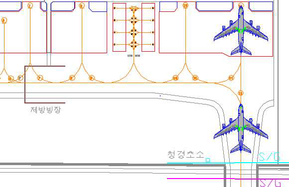
2) Push back Procedures
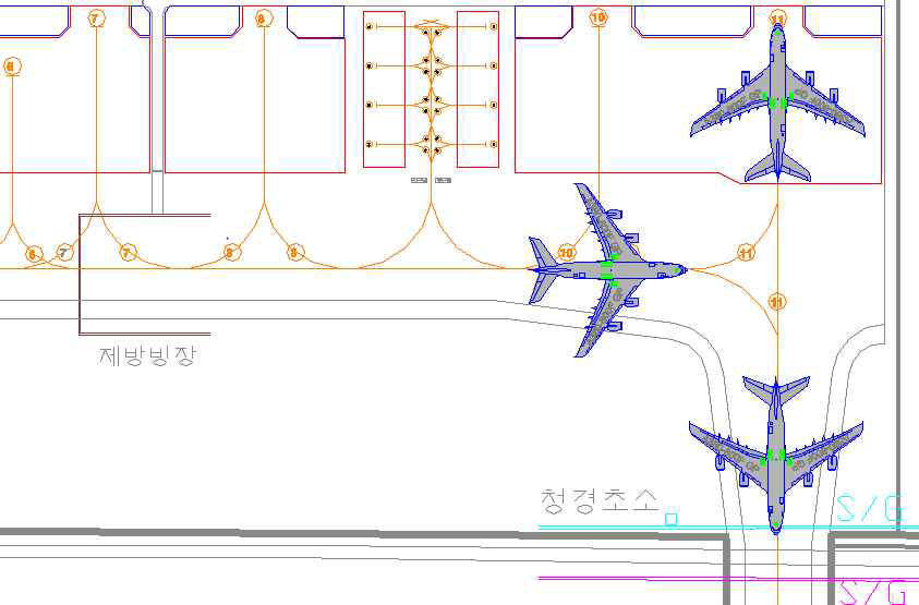
-
On the area of RWY, TWY A3 (including the curved part of TWY) and apron, ICAO code letter “F“ aircraft should move at a speed of below 30 kt except for the departure maneuvering, which pilots should make his engines idle power, adjusting the speed only with operating brake system by inertia. Especially, A380 movement procedure is as follows :
A380 Landing maneuvering
Section
Status of engine
Speed
No. 2 & 3
No. 1 & 4
Runway maneuvering
Idle power
Idle power
- Below 30 kt
Turning pad
Idle power
Idle power
- Maintain 5 kt
- Below 30 kt (After turning)
Taxiway/Apron
Idle power
Shut down
- 7~8 kt
A380 Departure maneuvering
Section
Status of engine
Speed
No. 2 & 3
No. 1 & 4
Taxiway/Apron
Idle power
Idle power
- 7~8 kt
Runway maneuvering
Idle power
Idle power
- Below 30 kt
Turning pad
Idle power
Idle power
- maintain 5 kt
- below 30 kt (after turning)
※ A380 Aircraft to be taxied with their engine thrust 4~6% (When turning, aircraft should keep 10% thrust using one outer engine of opposite turning direction)
RKTU AD 2.21 NOISE ABATEMENT PROCEDURES
|
NIL |
RKTU AD 2.22 FLIGHT PROCEDURES
1 Weather Minima
|
RWY 06L/24R | ||
|
ENG |
HIRL & RCLL or RCL |
Others |
|
2 or more ENG |
RVR / VIS 500 M |
RVR / VIS 800 M |
|
RWY Straight-in |
CAT |
DH/Visibility (M) |
HAT/HAA (FT) |
Ceiling(FT) | |
|
PAR |
06L |
A,B,C,D,E |
368 / 800 |
200 |
200 |
|
24R |
A,B,C,D,E |
386 / 800 |
200 |
200 |
|
RWY |
CAT |
DH/MDA-VIS |
CEIL-VIS | ||
|
R A D A R |
PAR |
24L |
A, B, C, D, E |
392-24 |
(200-1/2) |
|
6R |
A, B, C, D, E |
372-40 |
(200-3/4) | ||
|
A S R |
24L |
A,B |
880-40 |
(700-3/4) | |
|
C |
880-1 1/2 |
(700-1 1/2) | |||
|
D |
880-1 3/4 |
(700-1 3/4) | |||
|
E |
880-2 |
(700-2) | |||
|
6R |
A, B |
620-50 |
(500-1) | ||
|
C |
620-1 1/4 |
(500-1 1/4) | |||
|
D, E |
620-1 1/2 |
(500-1 1/2) | |||
|
CIR 24-6 |
A, B |
880(24L) / 860(24R)-1 |
(700-1) | ||
|
C |
880(24L) / 860(24R)-2 |
(700-2) | |||
|
D |
1 200-3 |
(1 100-3) | |||
|
E |
1 220-3 |
(1 100-3) | |||
|
CIR 6-24 |
A |
780-1 |
(600-1) | ||
|
B |
820-1 |
(700-1) | |||
|
C |
820-1 1/4 |
(700-1 3/4) | |||
|
D |
1 200-3 |
(1 100-3) | |||
|
E |
1 220-3 |
(1 100-3) | |||
2 VFR
-
General Conditions
-
Helicopter operation for Take-off or landing shall be made on B2. For helicopters with wheel-type landing gear, take-off/landing/taxiing shall be conducted on the runway only after obtaining the permission from the control tower.
-
After take-off, aircraft shall depart the traffic pattern to the northwest and any aircraft which want to take-off and cross the RWY 06R/24L shall obtain the prior permission from the control tower.
-
Traffic pattern altitude for helicopters is 1 000 FT except for B-412 helicopter and light aircraft.
-
-
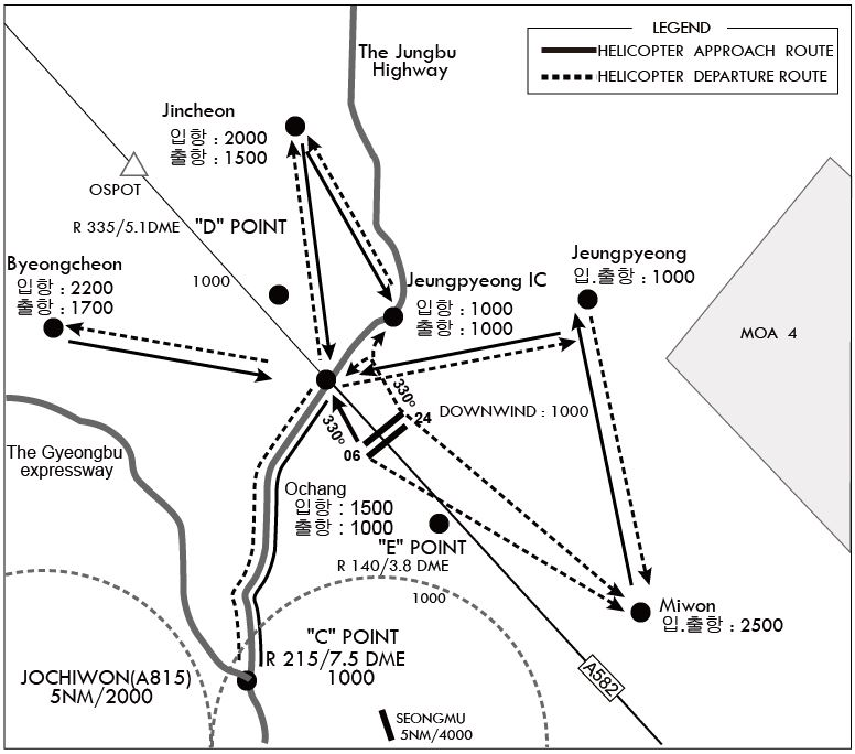
Procedure for departing traffic pattern (refer to the diagram)
-
RWY 24L/R in use
-
For aircraft departing the traffic pattern to the north
Turn right after take-off, then fly to the left side of OCHANG at 1 000 FT with broadcasting the position in the blind.
Fly to the right side of the National road 17 while keeping a sharp lookout for other aircraft entering or leaving Jincheon branch office(360°R 6 NM), the Forest Government Information Agency, then fly to the right side of the Jincheon Casemate(launching pad) at 1 500 FT and after broadcasting the position in the blind over the JINCHEON, depart to the destination.
-
For aircraft departing the traffic pattern to the west
After take-off, turn right and fly via OCHANG at 1 000 FT with broadcasting the position in the blind, then proceed to BYONGCHEN at 1 700 FT along the south of the National road 510, and after broadcasting the position in the blind over BYONGCHEN, depart to the destination.
-
For aircraft departing the traffic pattern to the south
- Take-off for crossing the runway 06R/24L shall be allowed only after obtaining the permission from the control tower.
- After take-off, turn left after obtaining the permission from the control tower and proceed direct to "C" Point at 1 000 FT.
- After take-off, maintain at or below 500 FT until passing through the end of the runway, and turn left after obtaining the permission from the control tower, depart to the destination via MIWON at 2 500 FT.
- If no permission is obtained from the control tower, maintain at or below 500 FT until passing the end of the runway, and turn right, then fly along the right side of JUNGBU Expressway, and after broadcasting the position in the blind over "C" Point at 1 000 FT, depart to the destination.
-
For aircraft departing the traffic pattern to the east
After take-off, turn right and proceed to JEUNGPYEONG at 1 000 FT via 'Down Wind leg' and depart to the destination after broadcasting the position in the blind over JEUNGPYEONG; or
After obtaining the permission from the control tower, cross the extended centerline of runway at or below 1 000 FT and depart to the destination.
-
-
RWY 06L/R in use
-
For aircraft departing the traffic pattern to the north
After take-off, turn left and maintain at or below 800 FT. Fly via the right side of JEUNGPYEONG Interchange at 1 000 FT. Proceed to JINCHEON at 1 500 FT along the JUNGBU Expressway and depart to the destination after broadcasting the position in the blind over JINCHEON.
-
For aircraft departing the traffic pattern to the west
After take-off, turn left and maintain at or below 800 FT. Fly via the right side of OCHANG at 1 000 FT along JUNGBU Expressway. and proceed to BUNGCHEON at 1 700 FT along the National road 510, and Depart to the destination after broadcasting the position in the blind over BUNGCHEON.
-
For aircraft departing the traffic pattern to the south
- Take-off for crossing the runway 06R/24L shall be allowed only after obtaining the permission from the control tower.
- After take-off, maintain at or below 500 FT until passing through the end of the runway, and after obtaining the permission from the control tower, turn right and depart to the destination via MIWON at 2 500 FT.
- When departing the traffic pattern via "C" point, turn right after passing through the end of runway and proceed to "C" Point at 1 000 FT via Down wind and Depart to the destination after broadcasting the position in the blind over "C" Point.
- Flying directly over downtown and school areas of Byeongcheon, Miwon and Ochang is prohibited.
-
-
-
Procedure for entering traffic pattern
-
For aircraft entering the traffic pattern from the southwest
Request landing clearance at "C" Point at 1 000 FT and enter the traffic pattern via the Ochang along the right side of the Jungbu Expressway at 1 000 FT and maintain at or below 1 000 FT until passing through the extended centerline of the runway.
-
For aircraft entering the traffic pattern from the west
After broadcasting the position in the blind over the Mokcheon Interchange, fly to the right side of Byeongcheon(right side of National road 21), then request landing clearance at Byeongcheon at 2 200 FT. Fly along the north of National Road 510, proceed to OCHANG at 1 500 FT and then enter the traffic pattern by descending to 1 000 FT.
-
For aircraft entering the traffic pattern from the north
Request landing clearance at Jincheon at 2 000 FT after broadcasting the position in the blind over Gwanghyewon and enter the traffic pattern via the right side of Jeungpyeong Interchange or via Ochang.
-
For aircraft entering the traffic pattern from the east
After broadcasting the position in the blind over Goesan, request landing clearance over Jeungpyeong at 1 000 FT, and enter the traffic pattern via Jeungpyeong Interchange at 1 000 FT.
-
For aircraft entering the traffic pattern from the northeast
After broadcasting the position in the blind over Eumseong, request landing clearance at Jeungpyeong at 1 000 FT, and enter the traffic pattern via Jeungpyeong Interchange at 1 000 FT.
* Flying directly over downtown and school areas of Byeongcheon, Miwon and Ochang is prohibited.
-
For aircraft entering the traffic pattern from the southeast
Fly via Miwon at 2 500 FT and request landing clearance at Jeungpyeong at 1 000 FT, Enter the traffic pattern via Jeungpyeong Interchange at 1 000 FT.
-
When RWY 06 R/L is in use, enter the traffic pattern by maintaining 1 000 FT over Ochang.
VFR aircraft reporting points
Jincheon
365127.01N 1272602.64E
"C"
363544.81N 1272512.94E
Jeungpyeong
364640.00N 1273630.00E
Ochang
364434.03N 1272747.39E
"D"
364546.75N 1272620.05E
Miwon
364305.06N 1273924.42E
Byeongcheon
364546.75N 1271800.32E
Jeungpyeong IC
364621.81N 1273025.87E
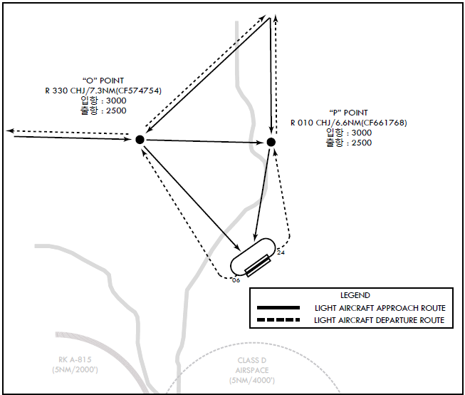
"O"
364851.41N 1272404.68E
"P"
364941.23N 1272957.93E
-
-
General Conditions
-
Use the runway 06L/24L and parking shall be made on civil ramp.
-
Use A3 or B3 taxiway for departing and after landing runway.
-
Use northern traffic pattern, maintain pattern altitude 1 000 FT(AMSL) and speed 100KIAS
-
Pattern Traffic is only three. When civil aircraft is departing or landing or ATC requires, pattern traffic is only two or less.
-
-
Procedure for departing(refer to the diagram)
-
RWY 24L/R in use
- Turn right in 1NM after take-off then direct to the destination via O point(2 500 FT). Turn left after take-off shall be allowed after obtaining the permission from the control tower.
-
RWY 24L/R in use
- Turn left in 1NM after take-off then direct to the destination via P point(2 500 FT). Turn right after take-off shall be allowed after obtaining the permission from the control tower.
-
-
Procedure for landing(refer to the diagram)
-
RWY 24L/R in use
-
For entering from the north or northeast REPORT outside of 10NM from the ARP Downwind enter via P point(3 000 FT).
-
For entering from the west or northwest REPORT outside of 10NM from the ARP Downwind enter via O point(3 000 FT).
-
For entering from the south or east REPORT outside of 10NM from the ARP before crossing the extended centerline of runway. Land via O point(3 000 FT) or P point(3 000 FT) or when traffic is no factor land via O point(3 000 FT) or P point(3 000 FT) after passing over the airport(4 500 FT).
-
Follow traffic seperation and condition enter after holding at O point(3 000 FT) or P point(3 000 FT) or direct Downwind enter.
-
-
RWY 06L/R in use
-
For entering from the north or northeast REPORT outside of 10NM from the ARP. Downwind 1 000 FT enter from O point(3 000 FT) or Downwind enter via P point(3 000 FT) or O point(3 000 FT)
-
For entering from the west or northwest REPORT outside of 10NM from the ARP. Downwind enter via O point(3 000 FT).
-
For entering from the south or east REPORT outside of 10NM from the ARP before crossing the extended centerline of runway. Land via O point(3 000 FT) or P point(3 000 FT) or when traffic is no factor land via O point(3 000 FT) or P point(3 000 FT) after passing over the airport(4 500 FT).
-
Follow traffic seperation and condition enter after holding at O point(3 000 FT) or P point(3 000 FT) or direct Downwind enter.
-
-
3 Radio Communication Failure Procedure
-
General
-
No person may take off unless two-way radio communication can be maintained with the Air Traffic Control.
-
On recognition of communication failure during flight, squawk 7600 and if necessary to ensure safe altitude, climb to Minimum Safe Altitude or above to maintain obstacle clearance. Then comply with following procedures
-
-
VFR condition
If the failure occurs in VFR conditions, or if VFR conditions are encountered after the failure, each pilot shall continue the flight under VFR and land as soon as practicable.
-
IFR condition
If the failure occurs in IFR conditions, or if paragraph 2 of this section cannot be complied with, each pilot shall continue the flight according to the following.
-
DEPARTURE
-
Under Pilot Navigation
RWY 24 in use
1) Cheongju 8 DEP
-
Climb heading 240° to CHJ/CHO 4DME, then right turn for the following routes.
- GUKDO TRANSITION : Turn right for interception R 314 CHJ/R 281 CHO to CHJ/CHO and at or above 6 000, then track outbound R 029 CHJ/CHO to GUKDO maintain 8 000 or assigned altitude by ATC.
- BITUX TRANSITION : Turn right for interception R 314 CHJ/R 281 CHO to CHJ/CHO and at or above 6 000, then track outbound R 143 CHJ/CHO to BITUX maintain 8 000 or assigned altitude by ATC.
- OLMEN/BULTI TRANSITION : Turn right heading 330° for interception R 281 CHJ/CHO, then track out bound R 281 CHJ/CHO to OLMEN/BULTI maintain 8 000 or assigned altitude by ATC.
2) RNAV GAKRI 1
-
Climb on 240° course to GAKRI, then...via(transition) and maintain 6 000.
- GUKDO TRANSITION(GAKRI1. GUKDO :...330° track to OKSAN, then via 060° track to TUTAE, then via 044° track to GUKDO.
- OSPOT TRANSITION(GAKRI1. OSPOT) :...330° track to OKSAN, then via 035° track to OSPOT.
- OSPOT TRANSITION(GAKRI1. OSPOT) :...330° track to OKSAN, then via 035° track to OSPOT.
- BITUX TRANSITION(GAKRI1. BITUX) :... 330° track to OKSAN, then via 060° track to WEBAX, then via 150° track to BILEE, then via 164° track to BOEUN, then via 141° track to BITUX..
RWY 06 IN USE
1) Cheongju 7 DEP
-
Climb heading 060° to CHJ/CHO 8DME, then left turn thence...
- GUKDO TRANSITION : Turn left heading 350° for interception R 029 CHJ/CHO, then track outbound R 029 CHJ/CHO to GUKDO maintain 8 000 or assigned altitude by ATC.
- BITUX TRANSITION : Turn left for interception R 017 CHJ/R 029 CHO to CHJ/CHO and at or above 6 000, then track outbound R 143 CHJ/CHO to BITUX maintain 8 000 or assigned altitude by ATC.
- OLMEN/BULTI TRANSITION : Turn left for interception R 017 CHJ/R 029 CHO to CHJ/CHO and at or above 6 000, then track outbound R 281 CHJ/CHO to OLMEN/BULTI maintain 7000 or assigned altitude by ATC.
2) RNAV BUKIL 1
-
Climb on 060° course to BUKIL, then... via(transition) and maintain 6000.
- GUKDO TRANSITION(BUKIL1. GUKDO) : ...007° track to GUKDO, cross GUKDO at or above 8 000.
- OSPOT TRANSITION(BUKIL1. OSPOT) :...330° track to TUTAE, then via 252° track to OSPOT.
- OLMEN/BULTI TRANSITION(BUKIL1. OLMEN/BULTI) :...330° track to TUTAE, then via 240° track to OWING, then via 280° track to OLMEN/BULTI.
- BITUX TRANSITION(BUKIL1. BITUX) :...330° track to TUTAE, then via 240° track to FERRA, then via 150° track to PODDE, then via 141° track to BOEUN, then via 141° track to BITUX.
-
-
Under Radar vectoring
- Proceed with the route from the point of radio failure to the fix, route, or airway specified in vector clearance,
- In the absence of an assigned route, proceed with the route that ATC has advised, which may be expected in a further clearance, or
- In the absence of an assigned route or a route that ATC has advised, which may be expected in a further clearance, proceed with the route filed in the flight plan, and
- Maintain minimum en-route altitude (MEA) or the altitude/flight level cleared in the last ATC clearance received, whichever is higher, for 5 minutes
- Continue the flight with altitude, flight level filed in the flight plan.
-
-
ARRIVAL
RWY 24 in use
-
VFR condition
The aircraft shall maintain VFR and make an approach to land at RWY 24 passing ICHG 7 DME FINAL.
-
IFR condition
The aircraft shall proceed to NOSON IAF and execute ILS/DME Y/Z RWY 24R or VOR/DME RWY 24R or RNAV RWY 24R or LOC/DME 24R APP.
RWY 06 in use
-
VFR condition
The aircraft shall maintain VFR and make an approach to land at RWY 06 passing HANJI 6 DME FINAL.
-
IFR condition
The aircraft shall proceed to JIKJI IAF and execute RNAV RWY 06L APCH.
-
-
-
VFR flight which has encountered radio communication failure shall
-
Helicopter
- SQ 7600, and
- When able to see light gun signal from control TWR, follow that instruction
- If unable to see light gun signal from control TWR, hold over downwind until ETA or for 10 minutes, whichever is later, then
- Land on RWY in use as filed, and take caution of landing and departing traffic.
-
-
Conventional flight
- SQ 7600, and
- When able to see light gun signal from control TWR, follow that instruction
- If unable to see light gun signal from control TWR, hold on downwind until ETA or for 10 minutes, whichever is later, then
- Aircraft should land on RWY in use
- Pilot shall take caution of landing and departing traffic.
RKTU AD 2.23 ADDITIONAL INFORMATION
-
Bird concentrations in the vicinity of the airport
Due to bird habitats in the vicinity of airport, pilots shall exercise caution not to conflict with the birds.
During one hour or two hours after daily sunrise, from January until march, and October until December, birds like a mallard move to fly from resting area(approximately 4~12 KM to the southwest of threshold of Runway (24R/06L) to feeding area(farmlands or airport). Also, from April until September in every year, during the same hours, birds which are mainly white-plumed egret and grey heron move from resting area(mountains which are located in approximately 1km far from airport) to feeding area(farmlands or airport). Besides, resident birds, such as magpie and skylark, sparrow, move in and out agricultural area near airport.
The activity altitude of birds is from 0 to 500 FT(150 M). Also, before daily sunset, activities of the birds occur above the same way when returning to the resting area during one hour or two hours.
Control tower shall offer pilots information about the birds's movement.
Furthermore, preventive activities against bird strikes, such as operation of B.A.T(Bird Alert Team) and devices (cannon, shotgun, etc) which scare birds away, shall be carried out. Also, the measures for eliminating resting or feeding area of birds is being taken in the airport boundary, although insufficient. On the properties of airport farming, garbage treatment facilities are not permitted.
