RKPU — Ulsan
RKPU AD 2.1 AERODROME LOCATION INDICATOR AND NAME
RKPU - ULSAN / Ulsan Domestic
RKPU AD 2.2 AERODROME GEOGRAPHICAL AND ADMINISTRATIVE DATA
|
1 |
ARP coordinates and site at AD |
353536N 1292108E 181° / 1 020 m from THR 18 |
|
2 |
Direction and distance from city |
039°, 7 km from Ulsan City Hall |
|
3 |
Elevation/Reference temperature |
13 m / 31. 4 °C |
|
4 |
Geoid undulation at AD ELEV PSN |
30 m |
|
5 |
MAG VAR/Annual change |
8° W (201 5 ) / 4′ increasing |
|
6 |
Aerodrome Operator, Address, Telephone, Telefax, AFS |
Post:
Ulsan Airport Branch (Busan Regional Office of Avi ation) 1103, Saneop-ro, Buk-gu, Ulsan, 683-410, Republic of Korea Tel: Tel: +82-52-289-4740 Fax: Telefax: +82-52-289-4750 AFS: AFS: RKPUYFYX |
|
7 |
Types of traffic permitted(IFR/VFR) |
IFR/VFR |
|
8 |
Remarks |
NIL |
RKPU AD 2.3 OPERATIONAL HOURS
|
1 |
Aerodrome Operator |
2100-1300 UTC |
|
2 |
Customs and Immigration |
NIL |
|
3 |
Health and Sanitation |
NIL |
|
4 |
AIS Briefing Office |
MON-SAT : 2200-1230 UTC SUN : 0030-1230 UTC |
|
5 |
ATS Reporting Office |
MON-SAT : 2200-1230 UTC SUN : 0030-1230 UTC |
|
6 |
MET Briefing Office |
H24 |
|
7 |
ATS |
MON-SAT : 2200-1230 UTC SUN : 0030-1230 UTC |
|
8 |
Fuelling |
NIL |
|
9 |
Handling |
HO |
|
10 |
Security |
HO |
|
11 |
De-icing |
MON-SAT : 2200-1230 UTC SUN : 0030-1230 UTC |
|
12 |
Remarks |
Outside these hours services are available under the pre-coordination (Only passenger flight) |
RKPU AD 2.4 HANDLING SERVICES AND FACILITIES
|
1 |
Cargo-handling facilities |
Conveyor belt, various vehicles and equipments |
|
2 |
Fuel/oil types |
NIL |
|
3 |
Fuelling facilities/capacity |
NIL |
|
4 |
De-icing facilities |
Available. See AD chart for location (ACFT Stand 1). |
|
5 |
Hangar space for visiting aircraft |
NIL |
|
6 |
Repair facilities for visiting aircraft |
NIL |
|
7 |
Remarks |
NIL |
RKPU AD 2.5 PASSENGER FACILITIES
|
1 |
Hotels |
In Ulsan city |
|
2 |
Restaurants |
60 Seats, light food services available at AD |
|
3 |
Transportation |
Buses, Taxis and rental cars available at AD |
|
4 |
Medical Facilities |
Ambulance services available Hospitals in Ulsan city |
|
5 |
Bank and Post Office |
Bank and Post Office available in the vicinity of AD |
|
6 |
Tourist Office |
Available at AD |
|
7 |
Remarks |
http://www.airport.co.kr/mbs/ulsan/ |
RKPU AD 2.6 RESCUE AND FIRE FIGHTING SERVICES
|
1 |
AD Category for fire fighting |
CAT 7 |
|
2 |
Rescue equipment |
- 2 Chemical Fire Fighting Trucks - 1 Ambulance Car - Water : 20 000 L - AFFF* : 4 120 L - Dry Chemical : 981.5 kg |
|
3 |
Capability for removal of disabled aircraft |
Specialized aircraft recovery equipment available for up to and including B737-900 size aircraft. The usable equipment list which is 50 ton hydraulic recovery jack, 50 ton crane and other accessory equipment can be provided by airlines. Korea Airports Corporation is the co-ordinator for the removal of disabled aircraft and can be reached at(Tel : +82-52-219-6312) Airport Duty Manager. |
|
4 |
Remarks |
NIL |
RKPU AD 2.7 SEASONAL AVAILABILITY - CLEARING
|
1 |
Type of clearing equipment |
|
|
2 |
Clearance priorities |
|
|
3 |
Remarks |
NIL |
RKPU AD 2.8 APRONS, TAXIWAYS AND CHECK LOCATIONS/POSITION DATA
|
1 |
Designation, Apron surface and strength |
|
|
2 |
Designation, Taxiway width, surface and strength |
|
|
3 |
Altimeter checkpoint location and elevation |
Location : At apron Elevation : 9 m |
|
4 |
VOR checkpoints |
NIL |
|
5 |
INS checkpoints |
See AD chart |
|
6 |
Remarks |
NIL |
RKPU AD 2.9 SURFACE MOVEMENT GUIDANCE AND CONTROL SYSTEM AND MARKINGS
|
1 |
Use of aircraft stand ID signs, TWY guide lines and visual docking/parking guidance system of aircraft stands |
Nosewheel guidelines on taxiways and apron |
|
2 |
RWY and TWY markings and LGT |
|
|
3 |
Stop bars |
NIL |
|
4 |
Remarks |
NIL |
RKPU AD 2.10 AERODROME OBSTACLES
|
In Approach/TKOF areas |
In circling area and at AD |
Remarks | |||
|---|---|---|---|---|---|
|
1 |
2 |
3 | |||
|
RWY/Area affected |
Obstacle type Elevation Marking/LGT |
Coordinates |
Obstacle type Elevation Markings/LGT |
Coordinates | |
|
36/APCH 18/TKOF |
Hill 1 339 ft |
354005.0N 1292136.1E | |||
|
Hill 1 113ft |
353941.7N 1292144.6E | ||||
|
Hill 424 ft |
353811.0N 1291931.3E | ||||
|
Hill 964 ft |
353931.0N 1291916.2E | ||||
|
Hill 1 774 ft |
354225.3N 1292053.9E | ||||
|
Mountain 2 444 ft |
354806.3N 1292043.1E | ||||
|
Hill 785 ft |
353839.7N 1291841.2E | ||||
|
18/APCH 36/TKOF |
Building 169 ft |
353425.1N 1292056.2E | |||
|
Pylon 346 ft |
353318.2N 1292158.7E | ||||
|
Pylon 427 ft |
353230.9N 1292128.2E | ||||
|
Hill 1 480 ft |
353526.7N 1292350.7E | ||||
|
contour 850 ft |
353521.6N 1292249.6E | ||||
|
Pylon 623 ft |
352842.8N 1292218.5E | ||||
|
Pylon 446 ft |
352928.3N 1292148.5E | ||||
|
Pylon 724 ft |
352621.6N 1291917.2E | ||||
|
Pylon 878 ft |
352517.5N 1291932.5E | ||||
|
Mountain 2 517 ft |
353958.6N 1291515.1E | ||||
RKPU AD 2.11 METEOROLOGICAL INFORMATION PROVIDED
|
1 |
Associated MET Office |
Ulsan Airport Weather Office (Tel : +82-52-289-0365, Telefax : +82-52-288-2392) |
|
2 |
Hours of service MET Office outside hours |
Aerodrome Operating hours |
|
3 |
Office responsible for TAF preparation Periods of validity |
Ulsan Airport Weather Office 30 hours at 0100, 0700, 1300, 1900 UTC |
|
4 |
Trend forecast Interval of issuance |
Trend Type forecast 1 hour (METAR) and when SPECI reported |
|
5 |
Briefing/consultation provided |
Available at the Office for 24 hours, if required |
|
6 |
Flight documentation Language(s) used |
Aerodrome forecasts (TAF code form), SIGWX charts, WINTEM charts, SIGMET information in English. |
|
7 |
Charts and other information available for briefing or consultation |
Analysis charts (surface and upper air), Prognostic charts, Graphic displays and other model outputs. |
|
8 |
Supplementary equipment available for providing information |
Satellite and Weather radar imageries, Wind profiler |
|
9 |
ATS units provided with information |
FIC and TWR |
|
10 |
Additional informaton (limitation of service, etc.) |
Automated METAR is provided during non-operational hours of the aerodrome. All observation data, model outputs and forecasts produced by KMA and WAFS are available at the office through internet link. |
RKPU AD 2.12 RUNWAY PHYSICAL CHARACTERISTICS
|
Designations Runway NR |
TRUE BRG |
Dimension of RWY(M) |
Strength(PCN) and surface of RWY and SWY |
THR coordinates RWY end coordinates THR geoid undulation |
THR elevation and highest elevation of TDZ of precision APP RWY | |||||||||||||||||||||
|---|---|---|---|---|---|---|---|---|---|---|---|---|---|---|---|---|---|---|---|---|---|---|---|---|---|---|
|
1 |
2 |
3 |
4 |
5 |
6 | |||||||||||||||||||||
|
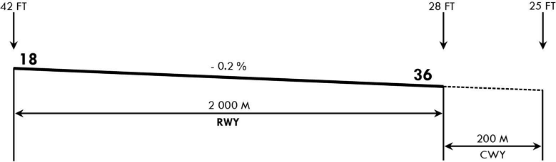
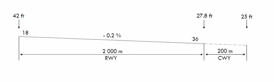
18 |
176.10° |
2 000 × 45 |
PCN 4 3 F/A/X/T ASPHALT |
353608.89N 1292103.54E GUND 30 m |
THR 13 m / 42 ft | |||||||||||||||||||||
|
36 |
356.10° |
2 000 × 45 |
PCN 4 3 F/A/X/T ASPHALT |
353504.15N 1292108.95E GUND 29.9 m |
THR 8.5 m / 27.8 ft TDZ 10.4 m / 34.1 ft | |||||||||||||||||||||
|
7. Slope of RWY-SWY | ||||||||||||||||||||||||||
  | ||||||||||||||||||||||||||
RKPU AD 2.13 DECLARED DISTANCES
|
RWY Designator |
TORA (M) |
TODA (M) |
ASDA (M) |
LDA (M) |
Remarks |
|---|---|---|---|---|---|
|
1 |
2 |
3 |
4 |
5 |
6 |
|
36 |
2 000 |
2 000 |
2 000 |
2 000 |
NIL |
|
36 |
840 |
840 |
840 |
- |
Take-off from intersection with A |
|
36 |
1 020 |
1 020 |
1 020 |
- |
Take-off from intersection with B |
|
18 |
2 000 |
2 200 |
2 000 |
2 000 |
NIL |
|
18 |
970 |
1 170 |
970 |
- |
Take-off from intersection with A |
|
18 |
790 |
990 |
790 |
- |
Take-off from intersection with B |
RKPU AD 2.14 APPROACH AND RUNWAY LIGHTING
|
RWY Designator |
APCH LGT type LEN INTST |
THR LGT Colour WBAR |
VASIS (MEHT) PAPI |
TDZ,LGT LEN |
RWY Center line LGT Length,Spacing Colour,INTST |
RWY edge LGT LEN,Spacing Colour INTST |
RWY End LGT Colour WBAR |
SWY LGT LEN(M) Colour |
Remarks |
|---|---|---|---|---|---|---|---|---|---|
|
1 |
2 |
3 |
4 |
5 |
6 |
7 |
8 |
9 |
10 |
|
18 |
SSALF 330 m LIH |
Green - |
PAPI Left/3.8° (59 FT) |
NIL |
NIL |
2 000 m 60 m White, LIH |
RED - |
NIL |
NIL |
|
36 |
ALSF-1 720 m LIH |
Green - |
PAPI Left/3° (56 FT) |
NIL |
NIL |
2 000 m 60 m White, LIH |
RED - |
NIL |
NIL |
RKPU AD 2.15 OTHER LIGHTING, SECONDARY POWER SUPPLY
|
1 |
ABN/IBN location, characteristics and hours of operation |
ABN : At tower building, FLG W/G EV 2~3 SEC/IBN : NIL H24 |
|
2 |
LDI location and LGT Anemometer location and LGT |
LDI : NIL Anemometer : NIL |
|
3 |
TWY edge and center line lighting |
|
|
4 |
Secondary power supply/swithch-over time |
Secondary power supply to all lighting at AD Switch-over time : 15 seconds |
|
5 |
Remarks |
NIL |
RKPU AD 2.16 HELICOPTER LANDING AREA
|
1 |
Coordinates TLOF or THR of FATO Geoid undulation |
- |
|
2 |
TLOF and/or FATO elevation M/FT |
- |
|
3 |
TLOF and FATO area dimensions, surface, strength, marking |
- |
|
4 |
True BRG of FATO |
- |
|
5 |
Declared distance available |
- |
|
6 |
APP and FATO lightng |
- |
|
7 |
Remarks |
As directed by ATC. |
RKPU AD 2.17 ATS AIRSPACE
|
1 |
Designation and lateral limit |
Ulsan CTR A circle, 5 NM radius centered at ARP |
|
2 |
Vertical limits |
SFC to 3 000 ft AGL |
|
3 |
Airspace classification |
D |
|
4 |
ATS unit call sign Languages |
Ulsan Tower English / Korean |
|
5 |
Transition altitude |
14 000 ft MSL. |
|
6 |
Operational hours |
MON-SAT : 2200-1230 UTC SUN : 0030-1230 UTC |
|
7 |
Remarks |
Refer to ENR 2.1-9, RKPU Visual Approach Chart to identify Class D airspace. |
RKPU AD 2.18 ATS COMMUNICATION FACILITIES
|
Service designation |
Call sign |
Channel |
Hours of operation |
Remarks |
|---|---|---|---|---|
|
1 |
2 |
3 |
4 |
5 |
|
APP |
Pohang Approach |
124.25 MHz 120.2 MHz 232.4 MHz |
H24 |
NIL |
|
Ulsan Arrival |
119.250 MHz 317.525 MHz |
MON-SAT : 2200-1230 UTC SUN : 0030-1230 UTC | ||
|
TWR |
Ulsan Tower |
118.75 MHz 236.6 MHz 124.35 MHz 225.55 MHz |
MON-SAT : 2200-1230 UTC SUN : 0030-1230 UTC |
Digital PDC service available |
|
ATIS |
Ulsan Airport |
127.625 MHz 233.55 MHz |
MON-SAT : 2200-1230 UTC SUN : 0030-1230 UTC |
Digital ATIS service available |
|
EMERG |
121.5 MHz 243.0 MHz |
MON-SAT : 2200-1230 UTC SUN : 0030-1230 UTC | ||
|
Scheduled Inspection Time - APP(124.25 MHz, 232.4 MHz, 119.250 MHz, 317.525 MHz), TWR, ATIS, EMERG : Every 1st WED(1400 - 2000 UTC) of the month. | ||||
RKPU AD 2.19 RADIO NAVIGATION AND LANDING AIDS
|
Type of aid, MAG VAR, Type of supported OPS |
ID |
Frequency |
Hours of operation |
Position of transmitting antenna coordinates |
Elevation of DME transmitting antenna |
Remarks |
|---|---|---|---|---|---|---|
|
1 |
2 |
3 |
4 |
5 |
6 |
7 |
|
LOC ILS CAT I |
IULS |
110.3 MHz |
H24 |
353616.3N 1292102.9E |
Scheduled Inspection time : Every 2nd WED(1400-2000 UTC) of the month | |
|
DME |
- |
1001 MHz (CH40) |
H24 |
353513.8N 1292112.2E |
0 M | |
|
GP |
- |
335 MHz |
H24 |
353513.8N 1292112.1E | ||
|
TVOR/DME |
USN |
111.4 MHz (CH51) |
H24 |
353554.6N 1292111.8E |
30 M |
Scheduled Inspection time : Every 3rd WED (1400-2000 UTC) of the month |
|
VOR unusable Radial 301-340 beyond 20DME below 8 000 FT Radial 261-300 beyond 12DME below 9 000 FT Radial 201-260 beyond 18DME below 7 000 FT Radial 151-160 beyond 19DME below 6 000 FT Radial 021-150 beyond 20DME below 10 000 FT Radial 000-020 beyond 22DME below 7 000 FT DME unusable Radial 301-340 beyond 16DME below 9 000 FT Radial 261-300 beyond 12DME below 9 000 FT Radial 201-260 beyond 16DME below 7 000 FT Radial 151-160 beyond 16DME below 6 000 FT Radial 021-150 beyond 10DME below 15 000 FT Radial 000-020 beyond 13DME below 11 000 FT | ||||||
|
RADAR(ASR/SSR) Scheduled Inspection time : Every 3rd WED (1400-2000 UTC) of the month | ||||||
RKPU AD 2.20 LOCAL AERODROME REGULATIONS
1 Airport Regulations
2 Ground Movement
3 Warning
(See AD 2-12 VFR Traffic Circuits).
(See AD 2-12 VFR Traffic Circuits).
(See AD 2-12 VFR Traffic Circuits).
4 Training Flights
RKPU AD 2.21 NOISE ABATEMENT PROCEDURES
1 Aircraft Operating Procedures(Except helicopter)
All departing aircraft should apply ICAO PANS - OPS(Doc 8168) Volume I Noise Abatement Departure Procedures One (NADP ONE).
-
Take-off to 800 FT AGL
- take-off power
- take-off flaps/slats setting
- initial climb speed is not less than V2 + 10 kt
-
At 800 FT AGL
- reduce power/thrust to Not less than climb power
-
800 FT AGL to 3 000 FT AGL
- maintain with flaps/slats in the take-off configuration
- climb at V2 + 10 to 20 KT
-
After passing an altitude of Not less than 3 000 ft AGL
- accelerate and retract flaps on schedule to En-route climb
For noise abatement using a reduced flap setting landing procedure is recommended. However, use of this procedure is subject to captain's decision and safety prevail at all times.
-
for approach to land on RWY 18;
- maintain intermediate flap setting until 1 NM prior to FAF.
- set final landing flaps within 1 NM prior to FAF.
-
for approach to land on RWY 36;
- maintain intermediate flap setting until 1 NM prior to FAF(FAP).
- set final landing flaps within 1 NM prior to FAF(FAP).
-
When the landing weight and runway length are enough,
-
When the runway condition is dry,
-
When the tailwind component is not existent,
-
Set the certificated shallow landing flaps in the approved performance section of the Airplane Flight manual to land.
-
if the runway is not clear and dry. i.e. it is adversely affected by, snow, slush, ice, water or other substances;
-
in conditions when the ceiling is lower than 500 ft, or when the horizontal visibility is less than 1.9 km.
-
when the cross-wind component, including gusts, exceeds 15 kt.
-
when the tailwind component, including gusts, exceeds 5 kt.
-
when the wind shear has been reported or forecast, or thunderstorms are expected to affect the approach.
Engine test shall be conducted with prior permission from the airport control tower. It shall be conducted at the approved place and approved conditions only. However, the power setting(s) shall not exceed idle thrust.
RKPU AD 2.22 FLIGHT PROCEDURES
1 IFR
Instrument flight procedures are based on the guidance contained in ICAO Doc 8168-Procedures for Air Navigation Service-Aircraft Operations(PANS-OPS), except instrument approach procedure for RWY 18(under FAA TERPS).
Refer to Instrument approach charts.
|
CATEGORY |
RWY |
Facilities | |||
|
REDL & RCLL |
REDL & RCL |
REDL or RCL |
NIL (Day Only) | ||
|
Multi-Engine ACFT with TKOF ALTN AD |
18 |
400 m / 1 200 ft |
400 m / 1 200 ft |
400 m / 1 200 ft |
500 m / 1 600 ft |
|
36 |
400 m / 1 200 ft |
400 m / 1 200 ft |
400 m / 1 200 ft |
500 m / 1 600 ft | |
|
OTHERS |
18 |
AVBL LDG MINIMA | |||
|
36 | |||||
|
Note : SIDs are designed in accordance with STANDARDS for FLIGHT PROCEDURE DESIGN
| |||||
Fuel Dumping Area is established within POHANG TMA as follows;
-
Area : A circle, 3 NM radius centered at R 100 USN/D12 (353520N 1293551E)
-
Altitude : 8 000 ft AMSL
2 VFR
VFR flight will be permitted under the condition as below;
-
Ground visibility : Not less than 5 km (3 SM)
(If Ground visibility is not reported, Flight visibility : Not less than 5 km)
-
Ceiling : At or above 450 m (1 500 ft)
-
CAT A, B : 1 500 ft AMSL
Departure procedure
-
After departing from RWY 18, pass the RWY end and reach the safe altitude, then fly the following routes ;
-
For NORTH bound : Turn right proceed to N for further ATC instructions. Cross N at or above 3 000 ft.
-
For WEST bound : Turn right proceed to W for further ATC instructions. Cross W at or above 2 000 ft.
-
For SOUTH bound : Turn right proceed to S or turn left proceed to E for further ATC instructions.
Cross S at or above 2 500 ft and E at or above 1 500 ft.
-
For EAST bound : Turn left proceed to E for further ATC instructions. cross E at or above 1 500 ft.
-
After departing from RWY 36, pass the RWY end and reach the safe altitude, then fly the following routes ;
-
For NORTH bound : Turn left proceed to N for further ATC instructions. Cross N at or above 3 000 ft.
-
For WEST bound : Turn left proceed to W for further ATC instructions. cross W at or above 2 000 ft.
-
For SOUTH bound : Turn left proceed to S via W for further ATC instructions. Cross S at or above 2 500 ft.
-
For EAST bound : Turn left proceed to E via W and S for further ATC instructions. Cross S at or above 2 500 ft.
Arrival procedure
-
Inbound from SOUTH/EAST/WEST : Proceed to W via a VFR reporting point or as instructed by ATC, then fly the following route. Cross W at or above 2 000 ft.
-
When RWY 18 in use : Enter into the right downwind leg at 1 500 ft(HEL 1 000 ft) then land on RWY 18 as instructed by ATC.
-
When RWY 36 in use : Enter into the left downwind leg at 1 500 ft(HEL 1 000 ft) then land on RWY 36 as instructed by ATC.
-
Inbound from NORTH : Proceed to N then fly the following route. Cross N at or above 3 000 ft.
-
When RWY 18 in use : Enter into the right downwind leg at 1 500 ft(HEL 1 000 ft) then land on RWY 18 as instructed by ATC.
-
When RWY 36 in use : Enter into the left downwind leg at 1 500 ft(HEL 1 000 ft) then land on RWY 36 as instructed by ATC.
-
The Ground visibility is not less than 1 500 m.
-
If ground visibility is not reported, the Flight visibility is not less than 1 500 m.
-
Get a clearance from ATC.
-
Stay clear of clouds.
-
Fly within control zone as cleared by ATC.
-
Maintain visual reference with surface or water.
-
Maintain at least 1 500 m of flight visibility.
※ At night(between sunset and sunrise), the pilot must have an instrument rating and the aircraft must be equipped for IFR flight under Aviation Act.(Except for helicopters)
3 Radio communication failure procedure
-
Squawk 7600
-
Continue to fly in VMC
-
Land at nearest suitable aerodrome
-
Squawk 7600
-
Proceed to and hold over west downwind for RWY 18/36, west bound; and
-
When able to see light gun signal from control tower, follow that instruction ; or
-
When unable to see light gun signal from control tower, hold over downwind for RWY 18/36 until ETA or for 10 MIN, whichever is longer ; then
-
Land on RWY 18/36 in use as appropriate.
* Pilot shall use caution traffic landing and take-off from/to runway.
-
Squawk 7600
-
Maintain the last assigned speed and level, or minimum flight altitude if higher, for a period of 7 MIN following ;
-
The time the transponder is set to Code 7600 ; or
-
The time the last assigned level or minimum flight altitude is reached ;
whichever is later and thereafter adjust level and speed in accordance with the filed flight plan ;
-
-
When being vectored or having been directed by ATC, proceed in the most direct manner possible to rejoin the current flight plan route no later than the next significant point, taking into consideration the applicable minimum flight altitude ;
-
Squawk 7600
-
Follow the STAR issued by ATC. When being vectored or having been directed by ATC, proceed in the most direct manner possible to join the STAR no later than the next significant point. then commence descent as filed.
-
Start approach to the assigned runway without delay.
-
If no specific runway for landing has been assigned, start approach to RWY 36 without delay.
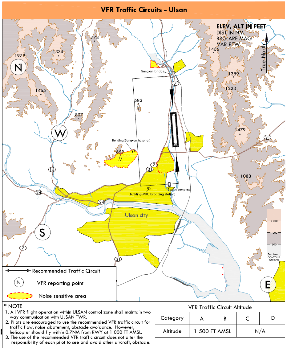
|
Reporting Point |
Geographical Name |
Position |
Coordinates |
Altitude(AMSL) |
|---|---|---|---|---|
|
N |
Guksubong(Mt.) |
5.8NM NW of Ulsan R 296 USN / D5.7 |
353746N 1291434E |
At or above 3 000 FT |
|
W |
Ulsan Wild Folower Learning Center |
4.0NM W of Ulsan R 272 USN / D4.0 |
353531N 1291617E |
At or above 2 000 FT |
|
S |
Ulsan Munsu Football Staduim |
5.7NM SW of Ulsan R 238 USN / D6.0 |
353207N 1291534E |
At or above 2 500 FT |
|
E |
Ulsan Dong-gu Office |
6.2NM SE of Ulsan R 158 USN / D6.4 |
353018N 1292500E |
At or above 1 500 FT |
RKPU AD 2.23 ADDITIONAL INFORMATION
-
Horizontal Surface height differs partially.
-
Bird concentrations in the vicinity of airport
Due to bird habitats in the Ulsan airport, pilots shall pay attention to crash with birds.
-
Every January until March, and every October until December in the one or two hours after sunrise, a flock of jackdaws moves from resting area (approximately 13 kilometers far away from the threshold of RWY 36) to the Dongcheon river or the field of airport
Also, every April until September in the same hours, there are concentrated activities that birds which are mainly white-plumed egret and grey heron move from resting area (mountains which are located in approximately 8 kilometers far away from the airport) to feeding area (nearby airport).
Additionally, resident birds, such as magpie and sparrow, always fly to the field nearby airport.
-
The activity altitude of birds is approximately 2 000 FT (600 M). Also, before sunset, activities of the birds occur above the same way when returning to the resting area during one or two hours.
-
Control tower shall offer pilots information about the movement of birds
-
Especially, during this time, control tower shall keep pilots informed that landing lights of aircraft are needed to turn on when take-off and approach for landing.
-
Furthermore, preventive activities against bird strikes, such as operation of B.A.T (Bird Alert Team) and devices (cannon, shotgun, etc) which scare birds away, shall be carried out. Also, the measures for eliminating resting or feeding area of birds is being taken in the airport boundary, not enough sufficient.
-
The measures are as followings :
spraying plants with insecticide and eliminating waterway or puddle, improving methods of waste disposal from the airport.
-
