RKJY — Yeosu
RKJY AD 2.1 AERODROME LOCATION INDICATOR AND NAME
RKJY - YEOSU / Domestic
RKJY AD 2.2 AERODROME GEOGRAPHICAL AND ADMINISTRATIVE DATA
|
1 |
ARP coordinates and site at AD |
345032N 1273702E 165° / 1 050 M from THR RWY 17 |
|
2 |
Direction and distance from city |
343°, 11 KM from Yeosu City Hall |
|
3 |
Elevation/Reference temperature |
16 M / 31 °C |
|
4 |
Geoid undulation at the aerodrome elevation |
27 M |
|
5 |
MAG VAR/Annual change |
7° W (2013) / 0.033° increasing |
|
6 |
Aerodrome Operator, Address, Telephone, Telefax, AFS |
Post:
Yeosu Airport Branch(Busan Regional Office of Aviation) Post:
386, Yeosun-ro, Yulchon-myeon,Yeosu-si, Jeollanam-do, 556-893 Republic of Korea Tel: Tel: +82-61-682-7886 Fax: Telefax: +82-61-685-7886 AFS: AFS: RKJYYFYX |
|
7 |
Types of traffic permitted (IFR/VFR) |
IFR/VFR |
|
8 |
Remarks |
NIL |
RKJY AD 2.3 OPERATIONAL HOURS
|
1 |
Aerodrome Operator |
2100 - 1300 UTC |
|
2 |
Customs and Immigration |
NIL |
|
3 |
Health and sanitation |
NIL |
|
4 |
AIS Briefing Office |
2200 - 1100 UTC |
|
5 |
ATS Reporting Office |
2200 - 1100 UTC |
|
6 |
MET Briefing Office |
HO |
|
7 |
ATS |
2200 - 1100 UTC |
|
8 |
Fuelling |
NIL |
|
9 |
Handling |
HO |
|
10 |
Security |
HO |
|
11 |
De-icing |
NIL |
|
12 |
Remarks |
Outside these hours services are available on request (Only passenger flight) |
RKJY AD 2.4 HANDLING SERVICES AND FACILITIES
|
1 |
Cargo handling facilities |
Conveyor belt, various vehicles and equipments |
|
2 |
Fuel/oil types |
NIL |
|
3 |
Fuelling facilities/capacity |
NIL |
|
4 |
De-icing facilities |
NIL |
|
5 |
Hangar space for visiting aircraft |
NIL |
|
6 |
Repair facilities for visiting aircraft |
NIL |
|
7 |
Remarks |
NIL |
RKJY AD 2.5 PASSENGER FACILITIES
|
1 |
Hotels |
In Yeosu & Suncheon city |
|
2 |
Restaurants |
At AD and in the city |
|
3 |
Transportation |
Buses, Taxis, Rental cars from AD |
|
4 |
Medical Facilities |
|
|
5 |
Bank and Post Office |
|
|
6 |
Tourist Office |
Available at AD |
|
7 |
Remarks |
http://www.airport.co.kr/mbs/yeosu/ |
RKJY AD 2.6 RESCUE AND FIRE FIGHTING SERVICES
|
1 |
AD Category for fire fighting |
Category 7 |
|
2 |
Rescue equipment |
- 2 chemical fire fighting trucks - Water : 22 000 Liters - AFFF* : 2 800 Liters - Dry chemical : 500 kg - 1 Ambulance car |
|
3 |
Capability for removal of disabled aircraft |
Specialized aircraft recovery equipment available for up to and including A321 size aircraft. 100 ton hydraulic recovery jack, 470 ton crane and other accessory equipment can be provided by airlines and agencies. Korea Airports Corporation is the co-ordinator for the removal of disabled aircraft and can be reached at Airport Duty Manager. (Tel: +82-61-689-6312) |
|
4 |
Remarks |
* Aqueous Film Forming Foam(AFFF) |
RKJY AD 2.7 SEASONAL AVAILABILITY - CLEARING
|
1 |
Type of clearing equipment |
|
|
2 |
Clearance priorities |
|
|
3 |
Remarks |
Snow clearance information promulgated by SNOWTAM |
RKJY AD 2.8 APRONS, TAXIWAYS AND CHECK LOCATIONS/POSITIONS DATA
|
1 |
Designation, Apron surface and strength |
|
|
2 |
Designation, Taxiway width, surface and strength |
|
|
3 |
Altimeter check location and elevation |
Location : At apron Elevation : 19 m |
|
4 |
VOR check points |
VOR : NIL |
|
5 |
INS check points |
INS : Refer to Aircraft Parking/Docking Chart |
|
6 |
Remarks |
NIL |
RKJY AD 2.9 SURFACE MOVEMENT GUIDANCE AND CONTROL SYSTEM AND MARKINGS
|
1 |
Use of aircraft stand ID signs, TWY guide lines and visual docking/parking guidance system of aircraft stands |
|
|
2 |
RWY and TWY markings and LGT |
|
|
3 |
Stop bars |
NIL |
|
4 |
Remarks |
NIL |
RKJY AD 2.10 AERODROME OBSTACLES
|
In Approach/TKOF areas |
In circling area and at AD |
Remarks | |||
|---|---|---|---|---|---|
|
1 |
2 |
3 | |||
|
RWY/Area affected |
Obstacle type Elevation Markings/LGT |
Coordinates |
Obstacle type Elevation Markings/LGT |
Coordinates | |
|
a |
b |
c |
a |
b | |
|
17/APCH 35/TKOF |
Antenna 1 598 ft |
345612.9N 1273831.5E | |||
|
Pylon 1 874 ft |
345945.9N 1273823.7E | ||||
|
Mountain 3 992 ft |
350622.7N 1273718.0E | ||||
|
Mountain 2 816 ft |
350523.3N 1273149.6E | ||||
|
Hill 1 822 ft |
350130.0N 1273338.5E | ||||
|
Hill 1 022 ft |
345831.0N 1273318.7E | ||||
|
Hill 394 ft |
345459.3N 1273358.4E | ||||
|
Mountain 2 394 ft |
350335.4N 1273141.6E | ||||
|
Hill 1 954 ft |
350138.8N 1273329.4E | ||||
|
Mountain 2 911 ft |
350004.7N 1271849.1E | ||||
|
Hill 1 166 ft |
345818.2N 1273023.0E | ||||
|
Pylon 590 ft |
345347.9N 12733346.5E | ||||
|
Mountain 2 192 ft |
345529.0N 1272100.2E | ||||
|
Hill 1 312 ft |
345603.4N 1273732.1E | ||||
|
Hill 63 ft |
345206.4N 1273634.4E | ||||
|
35/APCH 17/TKOF |
Light 521 ft |
344830.0N 1273729.5E | |||
|
Hill 1 076 ft |
345006.9N 1273534.3E | ||||
|
Hill 1 202 ft |
344902.6N 1273631.8E | ||||
|
Hill 1 267 ft |
344420.3N 1274229.5E | ||||
|
Hill 914 ft |
344501.4N 1273843.0E | ||||
|
Hill 820 ft |
345033.5N 1273613.1E | ||||
|
Hill 1 511 ft |
343723.7N 1274603.9E | ||||
|
Hill 1 352 ft |
343908.7N 1274500.2E | ||||
|
Hill 1 142 ft |
344441.3N 1273824.9E | ||||
RKJY AD 2.11 METEOROLOGICAL INFORMATION PROVIDED
|
1 |
Associated MET Office |
Yeosu Airport Weather Station (TEL : +82-61-682-7888, Telefax : +82-61-686-2365) |
|
2 |
Hours of service MET Office outside hours |
Aerodrome Operating hours |
|
3 |
Office responsible for TAF preparation Periods of validity |
Aviation Meteorological Office 30 hours at 0100, 0700, 1300, 1900 UTC |
|
4 |
Trend forecast Interval of issuance |
Trend Type forecast 1 hour (METAR) and when SPECI reported |
|
5 |
Briefing/consultation provided |
Avaliable at the station during aerodrome operating hours |
|
6 |
Flight documentation Language(s) used |
Aerodrome forecasts (TAF code form), SIGWX charts, WINTEM charts, SIGMET information in English |
|
7 |
Charts and other information available for briefing or consultation |
Analysis charts(surface and upper air), Prognostic charts, Graphic displays and other model outputs |
|
8 |
Supplementary equipment available for providing information |
Satellite and Weather radar imageries, Wind profiler |
|
9 |
ATS units provided with information |
FIC and TWR |
|
10 |
Additional informaton (limitation of service, etc.) |
Automated METAR is provided during non-operational hours of the aerodrome. All observation data, model outputs and forecasts produced by KMA and WAFS are available at the office through internet link. |
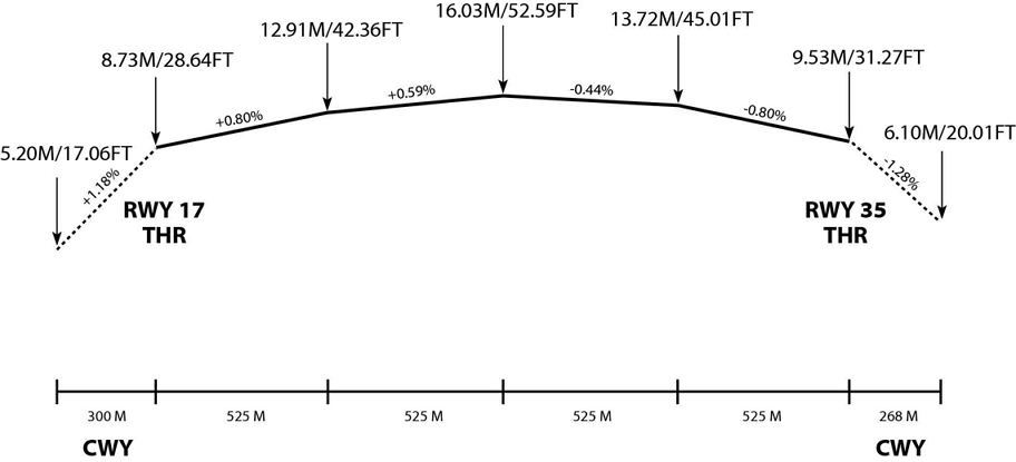
RKJY AD 2.12 RUNWAY PHYSICAL CHARACTERISTICS
|
Designations Runway NR |
TRUE BRG |
Dimension of RWY(M) |
Strength(PCN) and surface of RWY and SWY |
THR coordinates RWY end coordinates THR geoid Undulation |
THR elevation and highest elevation of TDZ of precision APP RWY |
|---|---|---|---|---|---|
|
1 |
2 |
3 |
4 |
5 |
6 |
|
17 |
158.03° |
2 100 × 45 |
67/F/C/X/T Asphalt |
345103.73N 1273646.77E GUND 27.2m |
THR 8.7m TDZ 13.7m |
|
35 |
338.03° |
2 100 × 45 |
67/F/C/X/T Asphalt |
345000.53N 1273717.70E GUND 27.2m |
THR 9.5 m TDZ 14.4 m |
|
7. Slope of RWY | |||||
 | |||||
|
SWY dimensions(M) |
CWY dimensions(M) |
Strip dimensions(M) |
OFZ |
Remarks | |
|---|---|---|---|---|---|
|
8 |
9 |
10 |
11 |
12 | |
|
NIL |
268 × 150 |
2 220 × 300 |
NIL |
· The surface of RWY 17/35 is grooved. | |
|
NIL |
300 × 150 |
2 220 × 300 |
NIL | ||
RKJY AD 2.13 DECLARED DISTANCES
|
RWY Designator |
TORA (M) |
TODA (M) |
ASDA (M) |
LDA (M) |
Remarks |
|---|---|---|---|---|---|
|
1 |
2 |
3 |
4 |
5 |
6 |
|
17 |
2 100 |
2 368 |
2 100 |
2 100 |
NIL |
|
17 |
1 500 |
1 768 |
1 500 |
- |
Take-off from intersection with A |
|
35 |
2 100 |
2 400 |
2 100 |
2 100 |
NIL |
|
35 |
1 600 |
1 900 |
1 600 |
- |
Take-off from intersection with B |
RKJY AD 2.14 APPROACH AND RUNWAY LIGHTING
|
RWY Designator |
APCH LGT type LEN INTST |
THR LGT Colour WBAR |
VASIS (MEHT) PAPI |
TDZ LGT LEN |
RWY Centre Line LGT Length,spacing Colour,INTST |
RWY edge LGT LEN Spacing Colour INTST |
RWY End LGT colour WBAR |
SWY LGT LEN(M) Colour |
Remarks |
|---|---|---|---|---|---|---|---|---|---|
|
1 |
2 |
3 |
4 |
5 |
6 |
7 |
8 |
9 |
10 |
|
17 |
ALSF-I 750 m LIH |
Green - |
PAPI Left / 3° (17.7 m) |
900 m |
2 100 m 30 m White/Red LIH |
2 100 m 60 m White LIH |
RED - |
- |
NIL |
|
35 |
SSALF 420 m LIH |
Green - |
PAPI Left/3° (17.7 m) |
NIL |
2 100 m 30 m White/Red LIH |
2 100 m 60 m White LIH |
RED - |
- |
PAPI unusable beyond 7° right side |
RKJY AD 2.15 OTHER LIGHTING, SECONDARY POWER SUPPLY
|
1 |
ABN/IBN location, characteristics and hours of operation |
ABN : At the top of TWR Building, FLG W/G EV 2 SEC/ IBN: NIL As AD operational hours |
|
2 |
LDI location and LGT Anemometer location and LGT |
LDI: NIL Anemometer : 350 m from THR 17, 350 m from THR 35 all lighted |
|
3 |
TWY edge and center line lighting |
Edge : All TWY Center line : NIL |
|
4 |
Secondary power supply/swithch-over time |
Secondary power supply to all lighting at AD Switch-over time: 1 or 15 second according to a kind of lights |
|
5 |
Remarks |
NIL |
RKJY AD 2.16 HELICOPTER LANDING AREA
|
1 |
Coordinates TLOF or THR of FATO Geoid undulation |
NIL |
|
2 |
TLOF and/or FATO elevation |
NIL |
|
3 |
TLOF and FATO area dimensions, surface, strength, marking |
NIL |
|
4 |
True BRG of FATO |
NIL |
|
5 |
Declared distance available |
NIL |
|
6 |
APP and FATO lightng |
NIL |
|
7 |
Remarks |
As directed by ATC. |
RKJY AD 2.17 ATS AIRSPACE
|
1 |
Designation and lateral limit |
Yeosu CTR A circle, radius 5 NM centered at ARP |
|
2 |
Vertical limits |
SFC to 3 000 ft AGL |
|
3 |
Airspace classification |
D |
|
4 |
ATS unit call sign Languages |
Yeosu Tower English / Korean |
|
5 |
Transition altitude |
14 000 ft AMSL. |
|
6 |
Operational hours |
2200-1100 UTC |
|
7 |
Remarks |
Refer to ENR 2.1-9, RKJY Visual approach chart to identify class D airspace |
RKJY AD 2.18 ATS COMMUNICATION FACILITIES
|
Service designation |
Call sign |
Channel |
Hours of operation |
Remarks |
|---|---|---|---|---|
|
1 |
2 |
3 |
4 |
5 |
|
APP |
Sacheon Approach |
135.4 MHz 344.7 MHz |
H24 |
Scheduled Inspection time : Every 4th THU(1300∼1800 UTC) of the month. |
|
Yeosu Arrival |
119.725 MHz 317.425 MHz |
2200-1100 UTC | ||
|
TWR |
Yeosu Tower |
122.5 MHz 240.9 MHz 121.5 MHz 243.0 MHz |
2200-1100 UTC | |
|
GND |
Yeosu Ground | 118.525 MHz |
2200-1100 UTC | |
|
ATIS |
Yeosu Airport |
128.275 MHz |
HO |
RKJY AD 2.19 RADIO NAVIGATION AND LANDING AIDS
|
Type of aid, MAG VAR, Type of supported OPS |
ID |
Frequency |
Hours of operation |
Position of transmitting antenna coordinates |
Elevation of DME transmitting antenna |
Remarks |
|---|---|---|---|---|---|---|
|
1 |
2 |
3 |
4 |
5 |
6 |
7 |
|
LOC 17 ILS CAT I |
IYSO | 111.5 MHz |
H24 |
344952.0N 1273722.0E |
- |
Scheduled Inspection Time : Every 1st THU (1300-1700 UTC) of the month |
|
DME 17 |
- |
1013 MHz (CH52) |
H24 |
345057.3N 1273654.6E |
30 m |
- |
|
GP 17 |
- |
332.9 MHz |
H24 |
345057.2N 1273654.4E |
- |
3° ILS RDH 46 ft |
|
LOC 35 |
IYSU |
109.7 MHz |
H24 |
345113.0N 1273642.2E |
- |
Scheduled Inspection Time : Every 2nd THU (1300-1700 UTC) of the month |
|
DME 35 |
- |
995 MHz (CH 34) |
H24 |
345010.5N 1273718.1E |
30 m | |
|
GP 35 |
- |
333.2 MHz |
H24 |
345010.4N 1273718.0E |
- |
3° ILS RDH 50 ft |
|
VOR/DME |
YSU |
115.7 MHz (CH104) |
H24 |
345034.2N 1273708.2E |
30 m |
VOR unusable : RDL 090-120 beyond 14 DME below 5 000 ft. RDL 121-155 beyond 18 DME below 5 000 ft. RDL 195-305 beyond 10 DME below 11 000 ft. DME unusable : RDL 090-120 beyond 12 DME below 6 000 ft. RDL 121-155 beyond 10 DME below 6 000 ft. RDL 195-305 beyond 6 DME below 17 000 ft. Scheduled Inspection Time : Every 3rd THU(1300-1700 UTC) of the month. |
|
Scheduled Inspection Time : - RADAR(PSR/SSR) : Every 3rd THU(1300 - 1700 UTC) of the month | ||||||
RKJY AD 2.20 LOCAL AERODROME REGULATIONS
-
Call sign or registration number
-
Stand number
-
Type of request, engine start or performance check
RKJY AD 2.21 NOISE ABATEMENT PROCEDURES
1 Aircraft Operating Procedures(Except helicopter)
Take off
NADP 1(RWY 17)
All departing aircraft should apply ICAO PANS-OPS(Doc 8168) Volume I Noise Abatement Departure Procedures One (NADP ONE).
-
Take-off to 1 100 FT AGL
- take-off power
- take-off flaps/slats setting
- initial climb speed is not less than V2 + 10 kt
-
At 1 100 FT AGL
- reduce power/thrust to Not less than climb power
-
1 100 FT AGL to 3 000 FT AGL
- maintain with flaps/slats in the take-off configuration
- climb at V2 + 10 to 20 KT
-
After passing an altitude of Not less than 3 000 FT AGL
- accelerate and retract flaps on schedule to En-route climb
Approach
For noise abatement using a reduced flap setting landing procedure is recommended. However, use of this procedure is subject to captain's decision and safety prevail at all times.
Delayed Flap setting Approach
-
for approach to land on RWY 17;
- maintain intermediate flap setting until 1 NM prior to FAF.
- set final landing flaps within 1 NM prior to FAF.
-
for approach to land onto RWY 35;
- maintain intermediate flap setting until 1 NM prior to FAF.
- set final landing flaps within 1 NM prior to FAF.
Reduced Flap setting Approach
-
When the landing weight and runway length are enough,
-
When the runway condition is dry,
-
When the tailwind component is not existent,
-
Set the certificated shallow landing flaps in the approved performance section of the Airplane Flight manual to land.
Continuous Descent Approach
While making ILS RWY 17 approach, all aircraft are recommended to conduct the Continuous Descent Approach as published on appropriate approach chart.
Exempted cases.
Aircraft need not be complied with the procedures described in paragraph 1.1 and 1.2 above in adverse operating conditions such as;
-
if the runway is not clear and dry. i.e. it is adversely affected by, snow, slush, ice, water or other substances;
-
in conditions when the ceiling is lower than 500 feet, or when the horizontal visibility is less than 1.9 KM.
-
when the cross-wind component, including gusts, exceeds 15 knots.
-
when the tailwind component, including gusts, exceeds 5 knots.
-
when the wind shear has been reported or forecast, or thunderstorms are expected to affect the approach.
Aircraft unable to comply with the procedures described in paragraph 1.1 and 1.2 above for any reason shall inform ATC.
Operational Limitations
Engine test shall be conducted with prior permission from the airport control tower. It shall be conducted at the approved place and approved conditions only. However, the power setting(s) shall not exceed idle thrust.
RKJY AD 2.22 FLIGHT PROCEDURES
1 IFR Procedure
Take-off Weather Minimum
|
CATEGORY |
RWY |
Facilities | |||
|
REDL & RCLL |
REDL & RCL |
REDL or RCL |
NIL (Day Only) | ||
|
Multi-Engine ACFT with TKOF ALTN AD |
17 |
400 m / 1 200 ft |
400 m / 1 200 ft |
400 m / 1 200 ft |
500 m / 1 600 ft |
|
35 |
400 m / 1 200 ft |
400 m / 1 200 ft |
400 m / 1 200 ft |
500 m / 1 600 ft | |
|
OTHERS |
17 |
AVBL LDG MINIMA | |||
|
35 | |||||
|
Note : SIDs are designed in accordance with STANDARDS for FLIGHT PROCEDURE DESIGN
| |||||
Fuel Dumping Area
Fuel Dumping Area is established within SACHEON TMA as follows;
-
Area : Circle with radius of 5 NM centered on YSU R-222 / D10.
-
Altitude : At or Above 6 000 FT AMSL.
Visual Approach
Visual approach may be initiated by ATC or approved upon pilot‘s request on traffic permitting basis at;
-
Ceiling : At or above 500 FT plus MVA (MVA of YEOSU CTR : 4 000 FT).
-
Visibility : Not less than 5 KM (3 SM).
2 VFR
VFR Procedures
-
VFR Weather Minimum
VFR flight will be permitted under the condition as below;
-
Ground Visibility : Not less than 5 000 M (3 SM)
(If Ground Visibility is not reported, flight Visibility should be no less than 5 000 M)
-
Ceiling : At or above 450 M (1 500 FT)
-
-
VFR Traffic Circuit : Refer to page RKJY AD 2-13.
-
VFR Traffic Circuit Altitude
-
CAT A, B, C : 1 300 FT
-
-
VFR Reporting Points : Refer to page RKJY AD 2-13.
-
VFR Flight Procedure for Helicopter
All VFR operations within YEOSU CTR shall maintain two way radio communication with YEOSU TWR.
Special VFR
-
Special VFR flight may be permitted when
-
ground visibility is not less than 1 500 M (Take-off and Landing); and
-
if ground visibility is not reported at airport, flight visibility is not less than 1 500 M (transition).
-
-
For Special VFR, the pilot shall
-
fly only within control zone as cleared by YEOSU TWR;
-
remain clear of clouds;
-
maintain at least 1 500 M of flight visibility; and
-
maintain visual reference with surface or water.
-
A pilot who is not qualified for instrument flight or not flying an aircraft not equipped with flight instruments for IFR flights prescribed in the Aviation Act shall only fly during daytime. However helicopter may be permitted to fly during night time.
-
-
Special-VFR flights may be permitted only between sunrise and sunset unless the pilot has instrument rating and the aircraft is equipped for IFR flight in accordance with the requirements specified in the Aviation Act of the Republic of Korea.
3 RADIO COMMUNICATION FAILURE PROCEDURE
IFR
-
General
-
No person may take off unless two-way radio communications can be maintained with the Air Traffic Control.
-
On recognition of communication failure during flight, squawk 7600 and if necessary to ensure safe altitude, climb to Minimum Safe Altitude or above to maintain obstacle clearance. Then comply with following procedure.
-
-
VFR condition
If the failure occurs in VFR conditions, or if VFR conditions are encountered after the failure, each pilot shall continue the flight under VFR and land as soon as practicable.
-
IFR condition
If the failure occurs in IFR conditions, or if paragraph 2 of this section cannot be complied with, each pilot shall continue the flight according to the following :
-
DEPARTURE
-
Proceed by the route, altitude/flight level assigned at the last ATC clearance received.
-
The time the last assigned route and altitude is reached ;
whichever is later and thereafter adjust route and altitude in accordance with the filed flight plan.
-
Under Radar vectoring
1) Proceed by the direct route from the point of radio failure to the fix, route, or airway specified in the vector clearance;
2) In the absence of an assigned route, proceed by the route that ATC has advised may be expected in a further clearance; or
3) In the absence of an assigned route or a route that ATC has advised may be expected in a further clearance, proceed by the route filed in the flight plan; and
4) Maintain minimum enroute altitude(MEA) or the altitude/flight level cleared in the last ATC clearance received, whichever is higher, for 5 minutes
5) Continue the flight with altitude/flight level filed in the flight plan.
-
-
ARRIVAL
Runway 17 in use
- Proceed to YEONA IAF or SKOTA IAF and commence descent and approach as close as possible to the expect futher clearence(EFC) issued by ATC or estimated time of arrival(ETA) filed in the flight plan; and
- Land, if possible, within 30 minutes after ETA or the last acknowledged EFC or ETA, whichever is later.
Runway 35 in use
- Proceed to SOONA IAF and commence descent and approach as close as possible to the expect further clearance time(EFC) issued by ATC or estimated time of arrival(ETA) filed in the flight plan; and
- Land, if possible, within 30 minutes after ETA or the last acknowledged EFC or ETA, whichever is later.
-
VFR
VFR flight which has experienced radio communication failure shall
-
Helicopter
-
Squawk 7600, and
-
When able to see light gun signal of control tower, follow that instruction
-
If unable to see light gun signal of control tower, hold over downwind until ETA or for 10 minutes, whichever is longer, then
-
Land on runway in use or STAND NO 5 as appropriate and as filed,
-
Pilot shall use caution traffic landing and take-off from/to runways.
-
-
Conventional flight
-
Squawk 7600, and
-
When able to see light gun signal of control tower, follow that instruction
-
If unable to see light gun signal of control tower, hold on downwind until ETA or for 10 minutes, whichever is longer, then
-
Aircraft on east pattern should land on runway 17/35
-
Pilot shall use caution traffic landing and takeoff from/to runways.
-
RKJY AD 2.23 ADDITIONAL INFORMATION
-
Bird concentrations in the vicinity of airport
There are mountains and sea near the Yeosu Airport. So vicinity of the airport has some resting and feeding areas of birds.
-
There is no specific tendency of migratory bird's habitat and migration route around the airport. Appearance of swallows from April to September, however, should get an attention. Also, in the rainy season, a flock of egrets appears both inside and outside of the airport.
-
Meanwhile, sedentary birds such as sparrow, magpie, and dove often appear both inside and outside of the airport including runways. They move from the feeding area(500 M south of the airport) to the airport.
-
In order to reduce the wildlife hazard in the vicinity of runway, wildlife control activities include distress call (Gas Cannon and AV-Alarm) and capture of harmfulness birds using shotgun.
