RKPD — Jeongseok
RKPD AD 2.1 AERODROME LOCATION INDICATOR AND NAME
RKPD - JEJU / Jeongseok
RKPD AD 2.2 AERODROME GEOGRAPHICAL AND ADMINISTRATIVE DATA
|
1 |
ARP coordinates and site at AD |
332354N 1264247E 011° / 1 709 m from THR 01 |
|
2 |
Direction and distance from city |
130°, 20.3km from Jeju City Hall 048°, 21.5km from Seogwipo City Hall |
|
3 |
Elevation/Reference temperature |
358 m / 27°C |
|
4 |
Geoid undulation at AD ELEV PSN |
26 m |
|
5 |
MAG VAR/Annual change |
7°W (2015) / 0.037° increasing |
|
6 |
Aerodrome Operator, Address, Telephone, Fax, AFS |
Post:
Korean air Post:
679-11, Noksan-ro, Pyoseon-myeon, Seogwipo-si, Jeju-do, 63622 Republic of Korea Tel: Tel : +82-64-780-0300 : +82-64-780-0350 Fax: Telefax: +82-64-780-0400 AFS: AFS : RKPDZPZX |
|
7 |
Types of traffic permitted(IFR/VFR) |
IFR/VFR |
|
8 |
Remarks |
NIL |
RKPD AD 2.3 OPERATIONAL HOURS
|
1 |
Aerodrome Operator |
MON-FRI : HJ(EXC holidays) |
|
2 |
Customs and Immigration |
NIL |
|
3 |
Health and Sanitation |
NIL |
|
4 |
AIS Briefing Office |
As AD operator |
|
5 |
ATS Reporting Office |
As AD operator |
|
6 |
MET Briefing Office |
As AD operator |
|
7 |
ATS |
As AD operator |
|
8 |
Fuelling |
As AD operator |
|
9 |
Handling |
As AD operator |
|
10 |
Security |
NIL |
|
11 |
De-icing |
NIL |
|
12 |
Remarks |
NIL |
RKPD AD 2.4 HANDLING SERVICES AND FACILITIES
|
1 |
Cargo-handling facilities |
NIL |
|
2 |
Fuel/oil types |
Fuel : Jet A-1 Oil : Turbo oil 2 380 |
|
3 |
Fuelling facilities/capacity |
Fuel services by truck / Jet A-1 : 10 600 L, AV GAS : 5 500 L |
|
4 |
De-icing facilities |
NIL |
|
5 |
Hangar space for visiting aircraft |
Not available |
|
6 |
Repair facilities for visiting aircraft |
Not available |
|
7 |
Remarks |
NIL |
RKPD AD 2.5 PASSENGER FACILITIES
|
1 |
Hotels |
In Jeju City |
|
2 |
Restaurants |
Near the AD |
|
3 |
Transportation |
Buses |
|
4 |
Medical facilities |
1 Ambulance service available Hospitals in Jeju City |
|
5 |
Bank and Post Office |
Not available |
|
6 |
Tourist Office |
Not available |
|
7 |
Remarks |
NIL |
RKPD AD 2.6 RESCUE AND FIRE FIGHTING SERVICES
|
1 |
AD Category for fire fighting |
Available : CAT 4 |
|
2 |
Rescue equipment |
∙ 1 chemical fire fighting trucks ∙ Water : 4 000 L ∙ AFFF : 400 L ∙ Dry Chemical : 140 kg ∙ 1 Ambulance car |
|
3 |
Capability for removal of disabled aircraft |
Equipment available on site by arrangement for light(Jet) aircraft. |
|
4 |
Remarks |
NIL |
RKPD AD 2.7 SEASONAL AVAILABILITY - CLEARING
|
1 |
Type of clearing equipment |
1 sweeper |
|
2 |
Clearance priorities |
RWY01/19 RWY33/15 TWY serving RWY in use Apron |
|
3 |
Remarks |
Snow clearance information promulgated by SNOWTAM |
RKPD AD 2.8 APRONS, TAXIWAYS AND CHECK LOCATIONS/POSITIONS
|
1 |
Apron surface and strength |
|
|
2 |
Taxiway width, surface and strength |
|
|
3 |
Altimeter checkpoint location and elevation |
Location : At apron Elevation : 352 M |
|
4 |
VOR checkpoints |
NIL |
|
5 |
INS checkpoints |
NIL |
|
6 |
Remarks |
Compass swing check PAD at end of RWY33 |
RKPD AD 2.9 SURFACE MOVEMENT GUIDANCE AND CONTROL SYSTEM AND MARKINGS
|
1 |
Use of aircraft stand ID signs, TWY guide lines and visual docking/parking guidance system of aircraft stands |
Nosewheel guidelines on taxiways and aprons. Following ground marshal for parking guidance. |
|
2 |
RWY and TWY markings and LGT |
|
|
3 |
Stop bars |
NIL |
|
4 |
Remarks |
NIL |
RKPD AD 2.10 AERODROME OBSTACLES
|
In Approach/TKOF areas |
In circling area and at AD |
Remarks | |||
|---|---|---|---|---|---|
|
1 |
2 |
3 | |||
|
RWY NR/ Area affected |
Obstacle type Elevation Marking/LGT |
Coordinates |
Obstacle type Elevation Marking/LGT |
Coordinates | |
|
01/APCH 19/TKOF |
Mountain 1 686 ft |
332257.6N 1264139.2E |
Mountain 1 451 ft |
332402.1N 1264322.0E | |
|
Mountain 1 667 ft |
332206.2N 1264131.4E |
Mountain 1 549 ft |
332356.9N 1264346.4E | ||
|
01/TKOF |
Mountain 1 401 ft |
332553.9N 1264211.3E |
NIL |
NIL | |
|
Mountain 1 546 ft |
332631.9N 1264303.9E | ||||
|
Mountain 1 548 ft |
332647.1N 1264230.7E | ||||
|
Mountain 1 706 ft |
332654.3N 1264142.4E | ||||
|
Mountain 1 502 ft |
332717.1N 1264305.5E | ||||
RKPD AD 2.11 METEOROLOGICAL INFORMATION PROVIDED
|
1 |
Associated MET Office |
Tower and FIS |
|
2 |
Hours of service MET Office outside hours |
As AD operational hour |
|
3 |
Office responsible for TAF preparation Periods of validity |
Not available |
|
4 |
Trend forecast Interval of issuance |
Not available |
|
5 |
Briefing/consultation provided |
Bulletin board & Telephone |
|
6 |
Flight documentation Language(s) used |
MET, TAF, SIG weather chart English |
|
7 |
Charts and other information available for briefing or consultation |
On request |
|
8 |
Supplementary equipment available for providing information |
Not available |
|
9 |
ATS units provided with information |
JEONGSEOK TWR and FIS |
|
10 |
Additional informaton (limitation of service, etc.) |
Model outputs and forecasts produced by KMA and WAFS are available at the office through Internet link. |
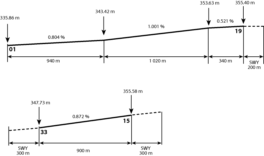
RKPD AD 2.12 RUNWAY PHYSICAL CHARACTERISTICS
|
Designations RWY NR |
TRUE BRG |
Dimension of RWY(M) |
Strength(PCN) and surface of RWY and SWY |
THR coordinates RWY end coordinates THR geoid undulation |
THR elevation and highest elevation of TDZ of precision APP RWY |
|---|---|---|---|---|---|
|
1 |
2 |
3 |
4 |
5 |
6 |
|
01 |
359.73° |
2 300 × 45 |
PCN 77/F/B/X/T Asphalt |
332258.36N 1264241.71E - GUND 25.9 m |
THR 335.9 m (1 102.0 ft) TDZ 342.0 m (1 122.0 ft) |
|
19 |
179.73° |
2 300 × 45 |
PCN 77/F/B/X/T Asphalt |
332413.01N 1264241.29E - GUND 26 m |
THR 355 m (1 166 ft) |
|
33 |
322.26° |
900 × 25 |
PCN 32/F/B/Z/T Asphalt |
332342.69N 1264255.55E - GUND 26 m |
THR 348 m (1 141 ft) |
|
15 |
142.26° |
900 × 25 |
PCN 32/F/B/Z/T Asphalt |
332405.79N 1264234.24E - GUND 26 m |
THR 356 m (1 167 ft) |
|
7. Slope of RWY-SWY | |||||
 | |||||
|
SWY dimensions(M) |
CWY dimensions(M) |
Strip dimensions(M) |
OFZ |
Remarks | |
|---|---|---|---|---|---|
|
8 |
9 |
10 |
11 |
12 | |
|
200 × 45 - |
- - |
2 620 × 300 |
Conforms to the standards specified in ANNEX14, Chapter4 |
NIL | |
|
300 × 25 300 × 25 |
- - |
1 620 × 150 | |||
RKPD AD 2.13 DECLARED DISTANCES
|
RWY Designator |
TORA (M) |
TODA (M) |
ASDA (M) |
LDA (M) |
Remarks |
|---|---|---|---|---|---|
|
1 |
2 |
3 |
4 |
5 |
6 |
|
01 |
2 300 |
2 300 |
2 500 |
2 300 | |
|
01 |
1 865 |
1 865 |
2 065 |
- |
Take-off from intersection with E |
|
01 |
1 350 |
1 350 |
1 550 |
- |
Take-off from intersection with D |
|
01 |
850 |
850 |
1 050 |
- |
Take-off from intersection with C |
|
19 |
2 300 |
2 300 |
2 300 |
2 300 | |
|
19 |
2 010 |
2 010 |
2 010 |
- |
Take-off from intersection with B |
|
33 |
900 |
900 |
1 200 |
900 | |
|
15 |
900 |
900 |
1 200 |
900 |
RKPD AD 2.14 APPROACH AND RUNWAY LIGHTING
|
RWY Designator |
APCH LGT type LEN INTST |
THR LGT Colour WBAR |
VASIS (MEHT) PAPI |
TDZ,LGT LEN |
RWY Center line LGT Length,Spacing, colour, INTST |
RWY edge LGT LEN, Spacing colour INTST |
RWY End LGT colour WBAR |
SWY LGT LEN(M) colour |
Remarks |
|---|---|---|---|---|---|---|---|---|---|
|
1 |
2 |
3 |
4 |
5 |
6 |
7 |
8 |
9 |
10 |
|
01 |
SSALF 420 M LIH |
Green - |
PAPI Both/3° (23.3 m) |
900 M |
2 300 M 30 M White/Red LIH |
2300 M 60 M White LIH |
Red |
NIL |
NIL |
|
19 |
NIL |
Green - |
PAPI left/3° (16.9 m) |
NIL |
2 300M 30 M White/Red LIH |
2 300 M 60 M White LIH |
Red |
NIL | |
|
33 |
NIL |
NIL |
NIL |
NIL |
NIL |
NIL |
NIL |
NIL | |
|
15 |
NIL |
NIL |
NIL |
NIL |
NIL |
NIL |
NIL |
NIL |
RKPD AD 2.15 OTHER LIGHTING, SECONDARY POWER SUPPLY
|
1 |
ABN/IBN location, characteristics and hours of operation |
ABN : At tower building, FLG W & G EV 2.5 s IBN : NIL As AD operational hour |
|
2 |
LDI location and LGT Anemometer location and LGT |
NIL |
|
3 |
TWY edge and center line lighting |
Edge : TWY A & B Center line lighting : NIL |
|
4 |
Secondary power supply/swithch-over Time |
Secondary power supply to all lighting at AD. Switch-over time : 15 s |
|
5 |
Remarks |
NIL |
RKPD AD 2.16 HELICOPTER LANDING AREA
|
1 |
Coordinates TLOF or THR of FATO |
NIL |
|
2 |
TLOF and/or FATO elevation M/FT |
NIL |
|
3 |
TLOF and FATO area dimensions, surface, strength, marking |
NIL |
|
4 |
True and BRG of FATO |
NIL |
|
5 |
Declared distance available |
NIL |
|
6 |
APP and FATO lightng |
NIL |
|
7 |
Remarks |
As directed by ATC |
RKPD AD 2.17 ATS AIRSPACE
|
1 |
Designation and lateral limit |
JEONGSEOK CTR A circle, 5 NM radius centered on ARP |
|
2 |
Vertical limits |
SFC to 3 000 FT AGL |
|
3 |
Airspace classification | Class D |
|
4 |
ATS unit call sign Language(s) |
JEONGSEOK TOWER Korean and English |
|
5 |
Transition altitude |
14 000 ft AMSL |
|
6 |
Remarks |
NIL |
RKPD AD 2.18 COMMUNICATION FACILITIES
|
Service designation |
Call sign |
Frequency(MHz) |
Hours of operation |
Remarks |
|---|---|---|---|---|
|
1 |
2 |
3 |
4 |
5 |
|
APP |
JEJU Approach |
121.2MHz, 124.05 MHz, 119.0 MHz, 317.7 MHz, 279.8 MHz |
H24 | |
|
DEP |
JEJU Departure |
119.225 MHz, 317.7 MHz |
H24 | |
|
TWR |
JEONGSEOK Tower |
124.35 MHz, 239.1 MHz |
As AD operational hour | |
|
GRD |
JEONGSEOK Ground |
121.95 MHz |
As AD operational hour | |
|
EMERG |
121.5 MHz, 243.0 MHz |
As AD operational hour | ||
|
ATIS |
NIL |
128.25 Mhz |
As AD operational hour |
RKPD AD 2.19 RADIO NAVIGATION AND LANDING AIDS
|
Type of aid, MAG VAR, Type of supported OPS |
ID |
Frequency |
Hours of operation |
Position of transmitting antenna coordinates |
Elevation of DME transmitting antenna |
Remarks |
|---|---|---|---|---|---|---|
|
1 |
2 |
3 |
4 |
5 |
6 |
7 |
|
DVOR/DME (7°W/2015) |
JDG |
117.9 MHz (CH 126X) |
H24 |
332331.8N 1264252.1E |
360 M |
DVOR unuse : RDL 255-280 beyond 13NM BLW 10 000 FT AMSL DME unuse : RDL 220-240 beyond 17NM BLW 4 500 FT AMSL RDL 255-280 beyond 13NM BLW 13 000 FT AMSL |
|
LOC 01 ILS CAT I |
IJDG |
108.3 MHz (CH 20X) |
H24 |
332422.7N 1264241.2E |
NIL | |
|
GP 01 |
— |
334.1 MHz |
H24 |
332307.5N 1264246.3E |
NIL | |
|
DME 01 |
(T) 981 MHz (R) 1 044 MHz |
H24 |
332307.8N 1264246.5E |
343 m |
NIL |
RKPD AD 2.20 LOCAL AERODROME REGULATIONS
1 VFR aircraft entering CATA 3 and CATA 6 should contact JEONGSEOK Tower to obtain traffic advisory and a clearance prior to entering.
2 All aircraft except the aircraft belonging to Koreanair that wish to use this AD should obtain an approval in advance from Koreanair
3 Pilots should always make sure that microphones are not stuck in the transmitting position before transmission in order to prevent freqeuncy blockage(stuck mike) from impairing ATC.
4 Ground engine check procedures
-
Aircraft requiring an engine check shall contact JEONGSEOK GND(121.95 MHz) and providing the following:
1) Call sign or registration number
2) Stand number
3) Type of request, engine start or performance check
-
Engine starts are permitted in the ramp area. However, the power setting shall not exceed idle thrust unless cleared by ATC.
-
During the engine check, pilot shall monitor the frequency of JEONGSEOK GND(121.95 MHz).
RKPD AD 2.21 NOISE ABATEMENT PROCEDURES
|
NIL |
RKPD AD 2.22 FLIGHT PROCEDURES
1 TAKE OFF MINIMUM
|
TYPE |
RWY |
A/C CAT |
REDL & RCLL OR RCL |
|---|---|---|---|
|
VIS | |||
|
Multi-Engine ACFT with TKOF ALTN AP FILED |
01 |
A,B,C,D |
500m |
|
19 | |||
|
OTHERS |
01 |
A,B,C,D |
AVBL LDG MINIMA |
|
19 | |||
|
15 |
A |
VMC | |
|
33 | |||
|
Note : SIDs are designed in accordance with STANDARDS for FLIGHT PROCEDURE DESIGN. | |||
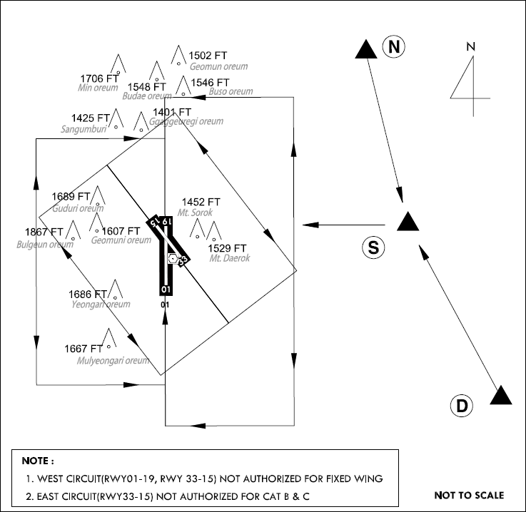
2 Procedures for VFR flight within Jeongseok CTR
VFR procedures
-
VFR Weather Minimum
VFR flight will be permitted under the condition as below :
-
Ground Visibility : Not less than 5 km (3 SM)
-
Ceiling : at or above 450 m (1 500 ft)
-
-
VFR Traffic Circuit : Refer to page RKPD AD 2 - 11
-
VFR Reporting point : Refer to page RKPD AD 2 - 11
-
VFR Circuit Altitude : Refer to page RKPD AD 2 - 11
-
VFR Flight procedure
-
All VFR operations shall maintain two way communication with JEONGSEOK TWR before entering JEONGSEOK CTR.
-
VFR Reporting Points, inbound routes and altitude as below :
Point R (3 600 FT) → Point Y (3 100 FT) → Downwind
Point D (3 600 FT) → Point Y (3 100 FT) → Downwind
-
Special VFR
-
A pilot of special VFR flight shall fly in accordance with each of the following:
- fly within permitted control zone
- fly to avoid clouds
- fly maintaining flight visibility of 1 500 m or more
- fly in a condition to be able to see surface of land or water at all times
- A pilot who is not qualified to instrument flight or is not flying an aircraft not equipped with flight instruments for IFR prescribed in Aviation Act shall only fly during daytime. However SVFR helicopter may be permitted to fly during night time
-
Special VFR flight may be permitted to fly in accordance with following condition :
- Ground visibility shall be at least 1 500 m.
- Flight visibility shall be at least 1 500 m when ground visibility has not been reported.
- Except helicopter.
3 RADIO COMMUNICATION FAILURE PROCEDURE
In VMCs:
-
1) Squawk 7600
-
2) Continue to fly in VMC
-
3) Land at nearest suitable aerodrome
Procedure for VFR Conventional flights
-
1) Squawk 7600, and
-
2) When able to see the light gun signal from control tower, follow that instruction, or
-
3) If unable to see the light gun signal from control tower, hold over "D"point until ETA or for 10 minutes, whichever is later; then
-
4) Land on runway in use on east pattern as appropriate.
-
5) Pilot shall use caution landing and departing traffic.
Procedure for VFR Helicopter flights
-
1) Squawk 7600, and
-
2) When able to see the light gun signal from control tower, follow that instruction, or
-
3) If unable to see the light gun signal from control tower, hold over "Y"point until ETA or for 10 minutes, whichever is later; then
-
4) Land on parallel taxiway "P" as appropriate.
-
5) Pilot shall use caution landing and departing traffic.
In IMCs or when conditions are such that it does not appear likely that the pilot will complete the flight in accordance with 3.1 :
DEPARTURE AIRCRAFT
-
1) Squawk 7600
-
2) Maintain the last assigned speed and level, or minimum flight altitude if higher, for a period of 7 minutes following:
-
i) the time the transponder is set to Code 7600; or
-
ii) the time the last assigned level or minimum flight altitude is reached;
whichever is later and thereafter adjust level and speed in accordance with the filed flight plan;
-
-
3) When being vectored or having been directed by ATC, proceed in the most direct manner possible to rejoin the current flight plan route no later than the next significant point, taking into consideration the applicable minimum flight altitude;
ARRIVAL AIRCRAFT
-
1) Squawk 7600
-
2) Follow the STAR issued by ATC. When being vectored or having been directed by ATC, proceed in the most direct manner possible to join the STAR no later than the next significant point. Then commence descent as filed.
-
3) Start approach to RWY 01 without delay.
RKPD AD 2.23 ADDITIONAL INFORMATION
|
NIL |
