RKPS — SACHEON
RKPS AD 2.1 AERODROME LOCATION INDICATOR AND NAME
RKPS - SACHEON / Domestic
RKPS AD 2.2 AERODROME GEOGRAPHICAL AND ADMINISTRATIVE DATA
|
1 |
ARP coordinates and site at AD |
350519N 1280414E 39° / 1 299 m from THR 06R | |
|
2 |
Direction and distance from city |
329°, 9.5 km from Sacheon City Hall | |
|
3 |
Elevation/Reference temperature |
8 m / 30˚C | |
|
4 |
Geoid undulation at AD ELEV PSN |
28 m | |
|
5 |
MAG VAR/Annual change |
7° W (2010) / 0.033˚ Increasing | |
|
6 |
Aerodrome Operator, Address, Telephone, Telefax, AFS |
Post:
MOLIT |
Post:
Sacheon Airport Office(Busan Regional Aviation Administration) 1971, Sacheon-daero, Sacheon-eup, Sacheon-si, Gyeongsangnam-do, 664-801 Republic of Korea Tel: Tel : +82-55-852-2568 Fax: Telefax : +82-55-852-6580 AFS: AFS : RKPSYFYX |
|
ROKAF |
Republic Of Korea Air Force(ROKAF) The 3rd Flight training Wing | ||
|
7 |
Types of traffic permitted(IFR/VFR) |
IFR/VFR | |
|
8 |
Remarks |
NIL | |
RKPS AD 2.3 OPERATIONAL HOURS
|
1 |
Aerodrome Operator |
2200 - 1300 UTC* |
|
2 |
Customs and Immigration |
NIL |
|
3 |
Health and Sanitation |
NIL |
|
4 |
AIS Briefing Office |
HO |
|
5 |
ATS Reporting Office |
HO |
|
6 |
MET Briefing Office |
H24 |
|
7 |
ATS |
H24 |
|
8 |
Fuelling |
HO |
|
9 |
Handling |
HO |
|
10 |
Security |
HO |
|
11 |
De-icing |
NIL |
|
12 |
Remarks |
* Outside these hours services are available under the Pre-coordination (passenger flights only) |
RKPS AD 2.4 HANDLING SERVICES AND FACILITIES
|
1 |
Cargo-handling facilities |
NIL |
|
2 |
Fuel/oil types |
J8/O-128, O-133(Available by agreement with ROKAF) |
|
3 |
Fuelling facilities/capacity |
NIL |
|
4 |
De-icing facilities |
One de-icing pad(Aircraft stand 1) |
|
5 |
Hangar space for visiting aircraft |
NIL |
|
6 |
Repair facilities for visiting aircraft |
NIL |
|
7 |
Remarks |
NIL |
RKPS AD 2.5 PASSENGER FACILITIES
|
1 |
Hotels |
Near AD and in the city |
|
2 |
Restaurants |
At AD(60 seats, light food service available) and in the city |
|
3 |
Transportation |
Buses, Taxis, rental and cars from AD |
|
4 |
Medical Facilities |
Hospitals in Sacheon city, 4 km |
|
5 |
Bank and Post Office |
Near AD and in the city |
|
6 |
Tourist Office |
At AD |
|
7 |
Remarks |
http://www.airport.co.kr/mbs/sacheon/ |
RKPS AD 2.6 RESCUE AND FIRE FIGHTING SERVICES
|
1 |
AD Category for fire fighting |
Category 7 |
|
2 |
Rescue equipment |
|
|
3 |
Capability for removal of disabled aircraft |
Specialized aircraft recovery equipment available for up to and including B737 size aircraft. 150 t crane and other accessory equipment can be provided by airlines and agencies. Korea Airports Corporation is the co-ordinator for the removal of disabled aircraft and can be reached at Airport Duty Manager Tel : +82-55-851-7311~7313 |
|
4 |
Remarks |
* : Aqueous Film Forming Foam |
RKPS AD 2.7 SEASONAL AVAILABILITY - CLEARING
|
1 |
Type of clearing equipment |
- ROKAF :
- KAC
|
|
2 |
Clearance priorities |
|
|
3 |
Remarks |
Snow clearance information promulgated by SNOWTAM |
RKPS AD 2.8 APRONS, TAXIWAYS AND CHECK LOCATIONS/POSITIONS DATA
|
1 |
Designation, Apron surface and strength |
|
|
2 |
Designation, Taxiway width, surface and strength: |
|
|
3 |
Altimeter check location and elevation: |
Aprons / 27 ft |
|
4 |
VOR/INS check points: |
VOR : NIL INS : Every specified aircraft stands(Refer to Aircraft Parking/Docking Chrat) |
|
5 |
Remarks |
NIL |
RKPS AD 2.9 SURFACE MOVEMENT GUIDANCE AND CONTROL SYSTEM AND MARKINGS
|
1 |
Use of aircraft stand ID signs, TWY guidelines and visual docking/parking guidance system of aircraft stands: |
|
|
2 |
RWY and TWY markings and LGT |
|
|
3 |
Stop bars |
NIL |
|
4 |
Remarks |
NIL |
RKPS AD 2.10 AERODROME OBSTACLES
|
In Approach/TKOF areas |
In circling area and at AD | |||
|---|---|---|---|---|
|
1 |
2 | |||
|
RWY NR/Area affected |
Obstacle type Elevation Marking/LGT |
Coordinates |
Obstacle type Elevation Markings/LGT |
Coordinates |
|
06L/R APCH |
Mountain 244 ft |
35°04′23.3″N 128°02′21.1″E |
Mountain 419 ft |
35°06′40.5″N 128°04′04.5″E |
|
Mountain 393 ft |
35°03′28.9″N 128°00′19.8″E |
Mountain 499 ft |
35°06′27.6″N 128°03′02.7″E | |
|
Mountain 419 ft |
35°01′14.2″N 127°58′03.7″E |
Mountain 607 ft |
35°08′10.6″N 128°03′49.5″E | |
|
Mountain 3 028 ft (Including Steel tower 243 ft) |
34°59′34.2″N 127°52′11.1″E |
Mountain 617 ft |
35°06′52.2″N 128°00′15.2″E | |
|
Mountain 735 ft |
35°05′14.2″N 127°58′03.1″E | |||
|
24L TKOF |
Mountain 244 ft |
35°04′23.2″N 128°02′20.8″E | ||
|
Mountain 2 630 ft |
34°58′51.0″N 128°05′56.6″E | |||
|
24R TKOF |
Mountain 213 ft |
35°04′47.1″N 128°02′37.9″E | ||
|
Mountain 2 630 ft |
34°58′51.0″N 128°05′56.6″E | |||
|
06L/R TKOF |
HILL 84 ft |
35°06′02.3″N 128°05′21.1″E | ||
|
Mountain 224 ft |
35°06′07.5″N 128°06′07.4″E | |||
|
Mountain 2 630 ft |
34°58′51.0″N 128°05′56.6″E | |||
|
24L/R APCH |
Hill 84 ft |
35°06′02.3″N 128°05′21.1″E | ||
|
Mountain 281 ft |
35°06′06.2″N 128°06′26.3″E | |||
|
Mountain 906 ft |
35°06′38.6″N 128°09′14.3″E | |||
|
3. Remarks: - Seawall 20 ft drop off RWY 06L THR - Mountain(244ft) : 6 233ft outward RWY 06L, 276ft Left(APCH) side from the extended centerline of RWY 06L - HILL(84ft) : 2 631ft outward RWY 24R, 20ft Right(APCH) side from the extended centerline of RWY 24R 2 631ft fr RWY 06L DER, 20ft((TKOF) Left of centerline 65ft AGL/84ft AMSL 2 131ft fr RWY 06R DER, 770ft(TKOF) Left of centerline 60ft AGL/84ft AMSL 4. Caution: - Obstacle(3 028 ft) locate at 10.6 NM from RWY 06L THR · Maintain at or above 3 600 ft until pass 11 DME of SAC when making VOR/DME RWY 06L APCH · Maintain at or above 3 600 ft until pass 12 DME of SAC when making VOR/DME RWY 06R APCH · Maintain at or above 3 600 ft until pass 11.6 DME of I-SAM when making LOC/DME RWY 06L APCH - Barriers(MA-1A) are installed on the OVERRUN of the RWY 06L/24R - Open drainage is located at both sides of the RWY 06L/24R - RUN-UP facilities (height 3.1 m) of Military aircraft located on 136 m inward from RWY 06L THR and 133 m leftward from RWY 06L/24R centerline - RWY Supervisor Units (height 5.9 m) · 443 m inward from RWY 06L THR and 164 m leftward from RWY 06L/24R centerline · 443 m inward from RWY 24R THR and 163 m rightward from RWY 06L/24R centerline | ||||
RKPS AD 2.11 METEOROLOGICAL INFORMATION PROVIDED
|
1 |
Associated MET Office |
Sacheon Airforce MET Office |
|
2 |
Hours of service MET Office outside hours |
24 hours - |
|
3 |
Office responsible for TAF preparation Periods of validity |
ROKAF MET Office 30 hours at 0000, 0600, 1200, 1800 UTC |
|
4 |
Trend forecast Interval of issuance |
Trend Type forecast (Gimhae Airport Weather Office) 1 hour (METAR) and when SPECI reported (ROKAF MET Office) |
|
5 |
Briefing/consultation provided |
Available at Gimhae Airport Weather Office for 24 hours, if required |
|
6 |
Flight documentation Language(s) used |
Aerodrome forecasts(TAF code form), SIGWX charts, WINTEM charts, SIGMET information in English |
|
7 |
Charts and other information available for briefing or consultation |
Analysis charts(surface and upper air), Prognostic charts, Graphic displays and other model outputs |
|
8 |
Supplementary equipment available for providing information |
Satellite and weather radar imageries |
|
9 |
ATS units provided with information |
FIC and TWR |
|
10 |
Additional informaton(limitation of service, etc.) |
All observation data, model outputs and forecasts produced by KMA and WAFS are available at the office through Internet link |
RKPS AD 2.12 RUNWAY PHYSICAL CHARACTERISTICS
|
Designations Runway NR |
TRUE BRG |
Dimension of RWY(M) |
Strength(PCN) and surface of RWY and SWY |
THR coordinates RWY end coordinates THR geoid undulation |
THR elevation and highest elevation of TDZ of precision APP RWY | |||||||||||||||||||||
|---|---|---|---|---|---|---|---|---|---|---|---|---|---|---|---|---|---|---|---|---|---|---|---|---|---|---|
|
1 |
2 |
3 |
4 |
5 |
6 | |||||||||||||||||||||
|
06R |
055.59° |
2 744 × 46 m |
PCN 69R/B/W/T Asphart |
350452.63N 1280334.87E |
THR 16 ft | |||||||||||||||||||||
|
24L |
235.60° |
2 744 × 46 m |
PCN 69R/B/W/T Asphart |
350542.93N 1280504.22E |
THR 24 ft | |||||||||||||||||||||
|
06L |
055.58° |
2 744 × 46 m |
PCN 76R/C/X/T Concrete |
350455.95N 1280324.81E |
THR 15 ft | |||||||||||||||||||||
|
24R |
235.59° |
2 744 × 46 m |
PCN 76R/C/X/T Concrete |
350546.26N 1280454.16E |
THR 19.3 ft TDZ 19.3 ft | |||||||||||||||||||||
|
7. Slope of RWY-SWY | ||||||||||||||||||||||||||
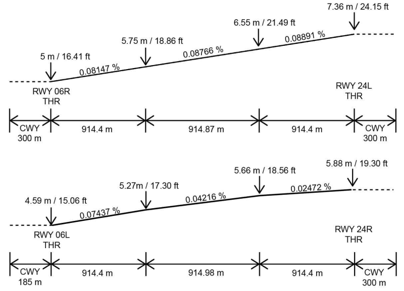 | ||||||||||||||||||||||||||
RKPS AD 2.13 DECLARED DISTANCES
|
RWY Designator |
TORA (m) |
TODA (m) |
ASDA (m) |
LDA (m) |
Remarks |
|---|---|---|---|---|---|
|
1 |
2 |
3 |
4 |
5 |
6 |
|
06R |
2 744 |
3 044 |
2 744 |
2 744 |
NIL |
|
24L |
2 744 |
3 044 |
2 744 |
2 744 |
NIL |
|
06L |
2 744 |
3 044 |
2 744 |
2 744 |
NIL |
|
24R |
2 744 |
2 929 |
2 744 |
2 744 |
NIL |
RKPS AD 2.14 APPROACH AND RUNWAY LIGHTING
|
RWY Designator |
APCH LGT type LEN INTST |
THR LGT Color WBAR |
VASIS (MEHT) PAPI |
TDZ LGT LEN |
RWY Center Line LGT Length, Spacing Color, INTST |
RWY edge LGT LEN, Spacing Color INTST |
RWY End LGT Color WBAR |
SWY LGT LEN(M) Color |
Remarks |
|---|---|---|---|---|---|---|---|---|---|
|
1 |
2 |
3 |
4 |
5 |
6 |
7 |
8 |
9 |
10 |
|
06R |
ALSF-I 762 m LIH |
Green |
PAPI Both/3° (53 ft) |
NIL |
NIL |
2 749 m 60 m WHITE LIH |
RED |
NIL |
NIL |
|
24L |
SSALS 304 m |
Green |
PAPI Both/3° (51 ft) |
NIL |
NIL |
2 749 m 60 m WHITE LIH |
RED |
NIL | |
|
06L |
ALSF-I 762 m LIH |
Green |
PAPI Both/3.7° (60 ft) |
NIL |
NIL |
2 749 m 60 m WHITE LIH |
RED |
NIL | |
|
24R |
NIL |
Green |
PAPI Both/3.2° (56 ft) |
NIL |
NIL |
2 749 m 60 m WHITE |
RED |
NIL |
RKPS AD 2.15 OTHER LIGHTING, SECONDARY POWER SUPPLY
|
1 |
ABN/IBN location, characteristics and hours of operation |
At hangar building (ROKAF) |
|
2 |
LDI location and LGT Anemometer location and LGT |
NIL |
|
3 |
TWY edge and center line lighting |
Edge : All TWY Center line : NIL |
|
4 |
Secondary power supply/swithch-over time |
Secondary power supply to all lighting at AD Switch-over time : 7-8 seconds |
|
5 |
Remarks |
NIL |
RKPS AD 2.16 HELICOPTER LANDING AREA
|
1 |
Coordinates TLOF or THR of FATO Geoid undulation |
- |
|
2 |
TLOF and/or FATO elevation(m/ft) |
- |
|
3 |
TLOF and FATO area dimensions, surface, strength, marking |
- |
|
4 |
True BRG of FATO |
- |
|
5 |
Declared distance available |
- |
|
6 |
APP and FATO lighting |
- |
|
7 |
Remarks |
As directed by ATC. |
RKPS AD 2.17 ATS AIRSPACE
|
1 |
Designation and lateral limit |
Sacheon CTR A circle, 5 NM radius centered at ARP |
|
2 |
Vertical limits |
SFC to 4 000 ft AGL |
|
3 |
Airspace classification |
C |
|
4 |
ATS unit call sign Language(s) |
Sacheon Tower English / Korean |
|
5 |
Transition altitude |
14 000 ft AMSL |
|
6 |
Operation hours |
H24 |
|
7 |
Remarks |
NIL |
RKPS AD 2.18 ATS COMMUNICATION FACILITIES
|
Service designation |
Call sign |
Channel |
Hours of operation |
Remarks |
|---|---|---|---|---|
|
1 |
2 |
3 |
4 |
5 |
|
APP |
Sacheon APP |
135.4 MHz 344.7 MHz |
H24 |
NIL |
|
DEP |
Sacheon DEP |
135.4 MHz 347.3 MHz |
H24 |
NIL |
|
ARR |
Sacheon ARR |
134.1 MHz 134.4 MHz 237.9 MHz 384.0 MHz |
H24 |
- Do not contact initial. - Caution : 134.1/134.4 MHz is jammed by the adjacent airports |
|
TWR |
Sacheon Tower |
126.2 MHz 236.6 MHz 305.4 MHz |
H24 |
UNREL COM : Radial 080-150 beyond 15 NM BLW 6 500 ft, due to terrain. |
|
GND DLVRY |
Sacheon Ground |
126.2 MHz 275.8 MHz |
H24 |
NIL |
|
ATIS |
Sacheon Airport |
126.225 MHz 225.475 MHz |
2100-1200 |
NIL |
|
VFR RADAR Advisery Service |
Sacheon Service |
135.4 MHz 230.8 MHz |
H24 |
Rader is required the service |
|
EMERGENCY |
121.5 MHz 243.0 MHz |
H24 |
NIL |
RKPS AD 2.19 RADIO NAVIGATION AND LANDING AIDS
|
Type of aid, MAG VAR, Type of supported OPS |
ID |
Frequency |
Hours of operation |
Position of transmitting antenna coordinates |
Elevation of DME transmitting antenna |
Remarks |
|---|---|---|---|---|---|---|
|
1 |
2 |
3 |
4 |
5 |
6 |
7 |
|
LOC 06L ILS CAT I |
ISAM |
109.1 MHz (CH 28X) |
H24 |
350550.6N 1280502.0E |
- |
NIL |
|
DME 06L |
ISAM |
TX: 989 MHz RX: 1 052 MHz |
H24 |
350550.2N 1280504.8E |
0 m |
NIL |
|
LOC 24R ILS CAT I |
ISHA |
108.1 MHz (CH 18X) |
H24 |
350452.6N 1280318.8E |
- |
NIL |
|
DME 24R |
TX: 979 MHz RX: 1 042 MHz |
H24 |
350544.2N 1280441.9E |
0 m |
NIL | |
|
GP |
334.7 MHz |
H24 |
350544.2N 1280441.8E |
0 m |
3.2° ILS RDH : 51 ft(ILS RWY 24R) | |
|
VOR/DME |
SAC |
115.1 MHz (CH 98) |
H24 |
350551.9N 1280434.7E | 0 m |
DME unusable Radial 310-040 beyond 18 NM BLW 10 000 ft Radial 110-180 beyond 17 NM BLW 6 000 ft |
|
Scheduled Inspection time - All radio navigation and landing aids : Every 3rd THD(1500-2000UTC) of the month. | ||||||
RKPS AD 2.20 LOCAL AERODROME REGULATIONS
1 Airport regulations.
Sacheon airport is jointly operated by MOLIT and ROKAF. All aircraft that wish to use this AD have to observe the Sacheon Airport Local Regulations. Information about the local regulation can be obtained from Sacheon ATC facilities(ROKAF, Tel.82-55-851-3232, 3237) and Flight Information Service station(MOLIT).
Pilots are required to monitor VHF 121.5 MHz(UHF 243.0 MHz) when flying within SACHEON TMA.
All non-scheduled flight aircraft that wish to operate in Sacheon airport have to obtain Prior Permission Required(PPR) between 72 hours and 24 hours prior to take-off by the Air Operation Center(AOC) of the 3rd Flight Training Wing (Tel.+82-55-851-3220/3221). Then, submit a flight plane to Sacheon Base Operations.
All other aircraft except KT-1 training aircraft make runway 06L-24R a rule to use.
2 Taxiing
Minimum separations taxiing aircraft.
-
Between Jet aircraft that type of aircraft differ each : 500 ft.
-
Between Heavy/large aircraft or Jet aircraft behind conventional aircraft : 2 000 ft.
All aircraft taxi at speed 10KTS or below, except when ATC instruct. If it is impracticable, pilot shall notify to ATC.
3 Fuel Dumping procedure
Fuel Dumping Area.
It is an area at either side 5 NM of Radial 190 between 27 DME and 32 DME from SAC/SCN.
Pilot shall notify to Sacheon TWR as follows.
-
A call sign and a type of aircraft.
-
A reason of dumping.
-
Other.
4 SACHEON Airport Runway strip, Runway end safety area is not satisfied with ICAO Safety recommendation at the moment. Therefore, refer to the following advice for the aviation safety. If the value of the surface friction measurements is less than 0.25, refrain from the aircraft operation
RKPS AD 2.21 NOISE ABATEMENT PROCEDURES
|
NIL |
RKPS AD 2.22 FLIGHT PROCEDURES
1 IFR Procedure
Refer to instrument Approach and Departure Charts.
Circling Approach
-
Circling not authorized in South East of Airport.
-
Circling Area radius for ROC(required obstacle clearance) as follows.
|
Approach Category |
Radius from threshold |
|
A |
1.3 NM |
|
B |
1.81 NM |
|
C |
2.84 NM |
|
D |
3.70 NM |
|
E |
4.63 NM |
Take-off weather minima
Apply the published take-off weather minima of the Standard Instrument Approach used.
IFR Departure
-
Standard Instrument Departure(SID) procedures are designed by U.S TREPS (CHG 25).
-
All aircraft – When departing using RWY 24L/R, maintain 35 FT AGL or above over DER.
Instrument Approach Procedure.
-
Instrument Approach procedures are designed by U.S TERPS (CHG 25).
-
When Sacheon Radar is unserviceable, CAT "E" Aircraft can use ONLY HI-TACAN-A Approach.
2 VFR Procedure
VFR Weather minimum
-
Ground visibility : Not less than 3 SM.
-
Flight visibility : Not less than 5 SM.
-
Ceiling : At or above 1 500 FT(Jet : 2 100 FT)
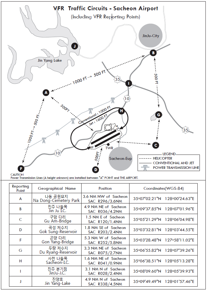
VFR Traffic circuit and VFR Reporting Point : RKPS AD 2 - 12
VFR Traffic pattern altitude
-
Helicopter : 500 FT
-
Conventional : 1 000 FT
-
Jet : 1 600 FT
VFR Flight procedure
-
VFR aircraft shall maintain two way radio communication and contact with Sacheon Approach out of 15NM.
-
All VFR Flight within Sacheon TMA shall set transponder at 12 plus the last two digits of the call sign.
-
Pilot who has insight runway or airport, follow the instruction of Sacheon Tower.
-
Helicopter VFR Flight procedure for Arrival is as follows.
-
Get a permission to enter class C airspace from Tower prior to 15 NM.
-
When VFR Routes enter through North, Maintain at or below 1 000 FT over JIN-YANG HO(A lake), then enter a VFR Traffic Pattern via reporting points ('A' or 'B' point, at or below 500 FT)
-
When VFR Routes enter through South, Maintain at or below 500 FT, then enter the control zone via reporting points ('C' or 'D' point, at or below 500 FT).
-
-
Helicopter VFR Flight procedure for Departure is as follows.
-
Take-off RWY 06
- When a aircraft bound to the South, Maintain at or below 300 FT to Duryang-Reservoir and turn right at outer Duryang-Reservoir, then fly at or below 500 ft within 5 NM radius of Sacheon airport.
- When a aircraft bound to the North, turn left at the end of RWY and maintain at or below 500 ft to JIN-YANG HO(A lake).
-
Take-off RWY 24
- When a aircraft bound to the South, Maintain at or below 300 FT to Gonyang Bridge and turn left, then fly at or below 500 ft within 5 NM radius of Sacheon airport.
- When a aircraft bound to the North, turn right at the end of RWY, then direct to the destination and maintain at or below 500 ft within 5 NM radius of Sacheon airport.
-
-
All aircraft passing Sacheon TMA in VFR shall contact with Sacheon Approach prior to 15 NM, and Fly 10 NM outside of Sacheon airport.
3 RADIO COMMUNICATION FAILURE PROCEDURE
IFR
-
General
- No person may take off unless two-way radio communications can be maintained with the Air Traffic Control.
- On recognition of communication failure during flight, squawk 7600 and if necessary to ensure safe altitude, climb to Minimum Safe Altitude or above to maintain obstacle clearance. Then comply with following procedures.
-
VMC
If the failure occurs in VFR conditions, or if VFR condition are encountered after the failure, each pilot shall continue the flight under VFR and land as soon as practicable (based on the runway in use).
-
IMC
If the failure occurs in IFR conditions, or if paragraph 2 of this section cannot be complied with, each pilot shall continue the flight according to the following :
-
DEPARTURE
-
Under Pilot Navigation
1) SACHEON 6 : Maintain at or below 7 000 FT until SCN/SAC R-360/D10, then proceed by the route, altitude/flight level assigned at the last ATC clearance received.
2) SACHEON 7 : Maintain at or below 7 000 FT until SCN/SAC R-200/D10, then proceed by the route, altitude/flight level assigned at the last ATC clearance received. Under Radar Vectoring
3) Proceed by the direct route from the point of radio failure to the fix, route, or airway specified in the vector clearance;
4) in the absence of an assigned route, proceed by the route that ATC will advise through the forthcoming clearance; or
5) in the absence of an assigned route or a route that ATC will advise through the forthcoming clearance, proceed by the route filed in the flight plan; and
6) Maintain minimum enroute altitude(MEA) or the altitude/flight level cleared in the last ATC clearance received, whichever is higher, for 20 minutes; then
7) Continue the flight with altitude/flight level filed in the flight plan
-
-
ARRIVAL
-
RWY 06 in use
1) in VMC
- The aircraft shall maintain VFR and make approach to land on RWY 06L/R.
2) in IMC
- The aircraft shall proceed to SOLYI IAF and execute (LOC/DME RWY 06L, VOR/DME RWY 06L, VOR/DME RWY 06R) APP.
-
RWY 24 in use
1) in VMC
- The aircraft shall maintain VFR and make approach to land on RWY 24L/R.
2) in IMC
- The aircraft shall proceed to CANTO IAF and execute (ILS RWY 24R, LOC/DME RWY 24R, VOR/DME RWY 24R, VOR/DME RWY 24L) APP.
* If able Civil aircraft is to use RWY 06L/24R
-
-
VFR
VFR flight which has experienced radio communication failure
- Squawk Mode 3/A code 7600, and
- When able to see light gun signal of control tower, follow that instruction
- If unable to see light gun signal of control tower, hold on downwind until ETA or for 10minutes, whichever is later, then
- Aircraft on north pattern should land on RWY in use
- Pilot shall use caution traffic landing and departing traffic.
RKPS AD 2.23 ADDITIONAL INFORMATION
1 CAUTION
-
Instrument student flight training in progress(All aircraft use extreme caution)
-
- HR : 2300-0900 UTC
-
- Area : Within 15 NM of aerodrome
-
- Altitude : Between 2 000 FT and 10 000 FT
-
-
Bird concentrations in the vicinity of airport
The area around Sacheon Airport is close to the seaside and is composed of wide farmland, so the activities of birds are frequent.
The pilots shall be careful of bird strikes.
-
- During one hour to two hours after daily sunrise, from January until March, and from October to December, The flock of mallards fly from resting area (approximately 1~2 KM to the threshold of RWY 06L) to feeding area(farmlands, waterway or airport).
Also, from April until September in every year, birds which are mainly white-plumed egret and grey heron move from resting area(mountains which are located in approximately 4 KM far away from airport) to feeding area(vicinity of airport).
Besides, resident birds, such as magpie and skylark, sparrow, move in and out agricultural area near airport.
-
- The activity altitude of birds is from 0 to 500 FT(150 M). Also, before daily sunset, when returning to the resting area activities of the birds occur above the same way during one hour or two hours.
-
- Air traffic control tower shall offer pilots information about the birds's movement and estimated activity altitude.
-
- Furthermore, preventive activities against bird strikes, such as playing the spasmodic distress signal, operating explosive sounds using by gas, and firing a gun by member of B.A.T(Bird Alert Team) which scare birds away, shall be carried out.
Also, it is difficult to completely remove the bird strike risk, but the measures for eliminating resting or feeding area of birds is being taken in the airport boundary. On the properties of airport farming, garbage treatment facilities are not permitted.
-
