ENR 1.2 VISUAL FLIGHT RULES
-
when the ceiling is less than 450 m (1500 ft); or
-
when the ground visibility is less than 5 km.
-
above FL 200;
-
at transonic and supersonic speeds.
-
when operated as special VFR flight
when operated as special VFR flight.
-
over the congested areas of cities, towns or settlements or over an open-air assembly of persons at a height less than 300 m(1 000 ft) above the highest obstacle within a radius of 600 m from the aircraft;
-
elsewhere than as specified in 5 a), at a height less than 150 m(500 ft) above the ground or water
elsewhere than as specified in 5 a), at a height less than 150 m(500 ft) above the ground or water.
-
when operated within Classes B, C and D airspace
when operated within Classes B, C and D airspace.
-
when operating in the vicinity of controlled aerodrome or maneuver area
when operating in the vicinity of controlled aerodrome or maneuver area.
-
when operated as special VFR flights
when operated as special VFR flights.
-
if a flight plan was submitted, communicate the necessary changes to be effected to its current flight plan, or
-
when so required by 3.3 of Annex 2, submit a flight plan to the appropriate air traffic services unit and obtain a clearance prior to proceeding IFR when in controlled airspace.
-
Purpose
The purposes of the instructions herein illustrated are to standardize flight procedures in order to prevent penetrating the (RK) P73 while flying in nearby areas, and to provide guideline for authorizing and restricting flights within the restricted airspace that are delegated to Minister of National Defence in accordance with [Aviation Safety Act] and [Regulations on delegating administrative authorities].
-
General
-
Applications
This guide applies to all units responsible for flight control in airspace (RK) P73, and any agency, organization or individual that wish to conduct any air activity in the vicinity of (RK) P73.
-
Terms
(RK) P73 : P73 airspace is a Prohibited flight zone in Seoul Metropolitan Area defined according to [Aviation Safety Act]. Horizontal and vertical range is as shown in ENR 1.2-24.
Horizontal range : The airspace that encircles the outside boundary of the radius of 2 NM centered at Center 1 and 2.
* Center1(373209N 1265838E), Center2(373232N 1265943E)
Vertical range : Surface ~ Unlimited
Vertical range : Surface ~ Unlimited
P73 VFR Route : VFR routes established to prevent helicopter flight which violates the (RK) P73, connecting well-known terrain feature on the ground for a visual flight in the vicinity of the (RK) P73. The P73 VFR route includes east, west, south, north corridor. (See ENR 1.2-24)
Han-gang Corridor : Nodeul corridor for helicopter traffics between Gimpo International airport and Nodeul-Seom and Yongsan corridor which was established for the in/out bound traffics of H-264. (See ENR 1.2-24)
R75 Restrict Area : Restricted flight zone in Seoul Metropolitan Area defined by [Aviation Safety Act] to identify and warn aircraft violating the P73. Horizontal and vertical range is as shown in ENR 1.2-24.
Other aviation activities : Activities such as but not limited to fireworks, flights of ultra light flight vehicles, UAV, and any light aircraft excluding aircraft defined under [Aviation Safety Act].
Violation flights : Any aircraft flight into P73, R75 with no proper clearance in advance, not complying to flight rules defined by [Aviation Safety Act] / violating restricted flight and prohibited activities regulations, and even if approved, any flight not adhering to the approved times, routes, altitude and the purpose of the flight will be considered as violation flight.
Identified Civil Aircraft : Civil aircraft which have been approved to fly in the P73 and or have taken required actions and also operating under the control of the ATC authorities applying Instrument Flight Rules. (flight plan notification, radar contact or etc)
“Army Joint Air-defense Operations Control Center” commands and controls air-defense and surveilance operations within the P73·R75 and ROK Capital Region. (hereinafter referred to as “CDC JAOC”). Call Sign : MASTER CONTROL.
ROKAF Air Defense Control Unit (MCRC) : ROKAF radar control units that provide radar monitoring and advisory services to any aircraft flying in the vicinity of P73. (PRIMARY : 1st MCRC, Alternate : 2nd MCRC)
“Guardian Air Information Center (Guardian AIC)” is the main control center of US Army aircraft conducting flight operations at the altitude of 800 ft above ground level or below within the Korean peninsula. It is a USFK control facility of which the main mission is to provide real-time air traffic control and flight information to mission aircraft. (hereinafter referred to as “Guardian AIC”).
“Yongsan Control Tower” is a unit which controls and provides flight information to aircraft conducting a flight mission within Hangang-river Corridor. (hereinafter referred to as “Yongsan Control Tower”.)
-
(RK) P73 : P73 airspace is a Prohibited flight zone in Seoul Metropolitan Area defined according to [Aviation Safety Act]. Horizontal and vertical range is as shown in ENR 1.2-22.
(RK) P73 : P73 airspace is a Prohibited flight zone in Seoul Metropolitan Area defined according to [Aviation Safety Act]. Horizontal and vertical range is as shown in ENR 1.2-24.
Horizontal range : The airspace that encircles the outside boundary of the radius of 2 NM centered at Center 1 and 2.
* Center1(373209N 1265838E), Center2(373232N 1265943E)
Vertical range : Surface ~ Unlimited
-
P73 VFR Route : VFR routes established to prevent helicopter flight which violates the (RK) P73, connecting well-known terrain feature on the ground for a visual flight in the vicinity of the (RK) P73. The P73 VFR route includes east, west, south, north corridor. (See ENR 1.2-22)
P73 VFR Route : VFR routes established to prevent helicopter flight which violates the (RK) P73, connecting well-known terrain feature on the ground for a visual flight in the vicinity of the (RK) P73. The P73 VFR route includes east, west, south, north corridor. (See ENR 1.2-24)
-
Han-gang Corridor :Nodeul corridor for helicopter traffics between Gimpo International airport and Nodeul-Seom and Yongsan corridor which was established for the in/out bound traffics of H-264. (See ENR 1.2-22)
Han-gang Corridor : Nodeul corridor for helicopter traffics between Gimpo International airport and Nodeul-Seom and Yongsan corridor which was established for the in/out bound traffics of H-264. (See ENR 1.2-24)
-
R75 Restrict Area : Restricted flight zone in Seoul Metropolitan Area defined by [Aviation Safety Act] to identify and warn aircraft violating the P73. Horizontal and vertical range is as shown in ENR 1.2-22.
R75 Restrict Area : Restricted flight zone in Seoul Metropolitan Area defined by [Aviation Safety Act] to identify and warn aircraft violating the P73. Horizontal and vertical range is as shown in ENR 1.2-24.
-
Exclusion Area From P73 (See ENR 1.2-25)
ID
Visual Reference
COORD (LAT-LONG/UTM)
Remarks
A
Northern Riverside Expressway
373206N 1270316E / CG 281 560
Along South edge of northern Riverside Expressway.
B
North end of Seongsu Bridge
373228N 1270210E/ CG 265 567
In a straight line
C
North end of Dongho Bridge
373223N 1270105E / CG 249 566
Along South edge of northern Riverside Expressway
D
North end of Hannam Bridge
373147N 1270042E / CG 243 555
E
Northern Riverside Expressway / Bokwang-dong
373127N 1270010E / CG 235 549
In a straight line
F
Itaewon entrance Intersection
373205N 1265911E / CG 221 561
Along the road
G
Samgakji Intersection
373208N 1265827E / CG 210 562
H
North end of Han-gang Bridge
373118N 1265743E / CG 199 547
Along South edge of northern Riverside Expressway
I
North end of Han-gang Railroad Bridge
373124N 1265723E / CG 194 549
J
North end of Mapo Bridge
373212N 1265628E / CG 181 564
K
North end of Seokang Bridge
373234N 1265543E / CG 170 571
L
North end of Yanghwa Bridge
373246N 1265425E / CG 151 575
M
North end of Seongsan Bridge
373330N 1265339E / CG 140 589
<Table 1> Check points demarcating the excluded area from P73
-
Other aviation activities : Activities such as but not limited to fireworks, flights of ultra light flight vehicles, UAV, and any light aircraft excluding aircraft defined under [Aviation Safety Act].
-
Violation flights : Any aircraft flight into P73, R75 with no proper clearance in advance, not complying to flight rules defined by [Aviation Safety Act] / violating restricted flight and prohibited activities regulations, and even if approved, any flight not adhering to the approved times, routes, altitude and the purpose of the flight will be considered as violation flight
-
Identified Civil Aircraft : Civil aircraft which have been approved to fly in the P73 and or have taken required actions and also operating under the control of the ATC authorities applying Instrument Flight Rules (flight plan notification, radar contact or etc)
-
Capital Defense Command (CDC JAOC) : ROK Army unit which commands and controls air defense operations within the airspace of P73 and the ROK Capital Region
-
P-73 Airspace Control Unit (P73 ACU): The radar operating organization under the Capital Defense Command which monitors and controls all air activities within and in the vicinity of P73.
-
ROKAF Air Defense Control Unit (MCRC) : ROKAF radar control units that provide radar monitoring and advisory services to any aircraft flying in the vicinity of P73. (PRIMARY: 1st MCRC, Alternate: 2nd MCRC)
-
Flight Coordination Center (FCC Guardian) : The unit providing real-time air traffic control and flight information to mission aircraft.
-
Policy
-
According to [Regulations on delegating administrative authorities], Minister of National Defence is entrusted with authorities on flight approval of aircraft in P73 and R75, who then delegates the authority to CDC CDR. Based on this guidance, CDC CDR executes flight approval and control within pertinent airspace.
-
Using its own radars, CDC JAOC will control the airspace of P73 NFZ and R75 RFZ in compliance with this guide and the existing regulations. If needed, JAOC will be supported by MCRC.
-
To insure full implementation of the procedures in this guide, all authorities concerned should revise and supplement their existing regulations and flight information publications(FLIP, AIP), and disseminate these procedures appropriately.
To insure full implementation of the procedures in this guide, all authorities concerned should revise and supplement their existing regulations and flight information publications, (FLIP, AIP)and disseminate these procedures appropriately.
-
Any entity (individual, unit, agency) planning to conduct flights or any other air activities within the R75 Restricted Area or VFR route must coordinate with the Captial Defense Command (JAOC or Protection Branch) in advance. However, aircraft flying in/out of the Seoul AB (K-16), which submitted its flight plan in advance, may conduct flights within the R75 Restricted Area without any pre-approval coordination.
Any entity (individual, unit, agency) planning to conduct flights or any other air activities within the R75 Restricted Area or VFR route must coordinate with the Captial Defense Command (JAOC or Fires Branch) in advance. However, aircraft flying in/out of the Seoul AB (K-16), which submitted its flight plan in advance, may conduct flights within the R75 Restricted Area without any pre-approval coordination.
-
Helicopter along the Han-gang Corridor must operate between the south and north edges of Han-gang, visually identifying both edges of the river. However, aircraft should fly south of the center of Hangang-river when passing (RK) P73 within Hangang-river Corridor, and flying north of river is only allowed under control by Yongsan Control Tower or during take-off/landing in Nodeul Helicopter Pod.
Aircraft flying along the Han-gang Corridor must operate between the south and north edges of Han-gang, visually identifying both edges of the river.
-
Aircraft without SSR/TRANSPONDER cannot fly along the VFR route or inside the R75 Restricted area. Aircraft with approval is to preset SSR code as assigned before entering the R75.
Aircraft without SSR/TRANSPONDER cannot fly along the VFR route or inside the R75 Restricted Area.
-
Night flights in R75 Restricted Area are prohibited with the exception of rescue flights in case of disaster or calamity, fire fighting and forest fire extinguishing flights, urgent medical evacuation flights, urgent flights for public purposes such as maintaining public order and enhancing public welfare etc, and military operation flights (including area familiarization flights).
Night flights in R75 Restricted Area are prohibited with the exception of rescue flights in case of disaster or calamity, fire fighting and forest fire extinguishing flights, urgent medical evacuation flights, urgent flights for public purposes such as maintaining public order and enhancing public welfare etc., and military operation flights (including area familiarization flights).
-
Close approach flights of fixed wing aircraft is defined as flight within 1 NM of VFR route when aircraft velocity is under 180 kt / within 3 NM of VFR route when aircraft velocity is over 180 kt.
-
When operating within the P73, one must follow the security procedures (security check of aircraft body, boarding of security agent, knowing urgent signaling, route/altitude deviation order and flight restriction) established by the CDC.
-
Weather limits of VFR route follow the standards outlined in the [Aviation Safety Act].
Weather limits of VFR route follow the standards outlined in the [Aviation Safety Regulation].
-
-
-
Urgent Flight Procedures in P73
Flight Procedures in P73
-
Pilots wishing to conduct flights in P73 must notify
their flight plans to CDC CDR (Ops Department -
Protection Branch) in written form.
Pilots wishing to conduct flights in P73 must notify their flight plans to CDC CDR (Ops Department - Fires Branch) verbally or in written form.
Flight Request
Category
P73
R75
Deadline for Approval Request
5 working days in advance
2 hours in advance of the flight
Request Procedure
Memorandum
* Recipient : CDC Protection Branch, 1st Air Defense Brigade JAOC
Civil pilots are to attach the following documents when submitting a flight plan.
National projects (wildfire surveillance, freight transport) : Copy of approval or request
Aerial filming : Copy of aerial filming approval by the unit responsible for the area
Aircraft of military operations (including command aircraft of GO-level or above) and government institute (command aircraft) must submit the flight request 5 workdays prior to the flight, but considering the urgency, if flight request cannot be submitted before the deadline, flight can be approved by consulting with CDC. However, permits of flights in P73, within the 1 NM radius of Center-1 and Center-2, airspace must be approved by Director of President's Guard in advance.
Approval Authority
Category
P73
R75
Flight
CDC CoS (G3) * Cooperate with PSS
JAOC Chief, CDC (Anti-aircraft control officer)
Urgent Flight
During working hours
CDC G3 (G33) * Cooperate with PSS
After working hours, Holidays
CDC Chief Duty Officer * Cooperate with PSS
JAOC Anti-aircraft control officer
Remarks
Pre-Approval of emergency flight(G3, Chief Duty Officer) then report to chief of staff, CDC)
-
CDC CDR may permit flights in P73 for public interest and military operations defined under b. General (3) Policy (g). However, permits of flights in P73, within the 1 NM radius of Center-1 and Center-2, airspace must be approved by Director of President's Guard in advance.
CDC CDR may permit flights in P73 for public interest and military operations defined under b. General (3) Policy (g). However, permits of flights in P73A airspace must be approved by Director of President's Guard in advance.
-
In the case of approved flights in P73, security personnel may be permitted on-board to check pilot adherence to flight rules and VFR of aircraft permitted to fly in P73. Pertinent procedures should be implemented and executed by CDC.
In the case of approved flights in P73, security Personnel may be permitted on-board to check pilot adherence to flight rules and VFR of aircraft permitted to fly in P73. Pertinent procedures should be implemented and executed by CDC.
-
Conditions for Approving Urgent Mission Flights in P73 are as follows.
Conditions for Approving Urgent Mission Flights in P73 are as follows
Urgent Flight in P73
Helicopters on flight with aircraft body check : authorization possible
Helicopters with aircraft body check that landed : Impossible
If flights come under the following criteria, flight is unauthorized in P73 NFZ.
When unable to confirm the veracity behind reason for Urgent flight.
When a mission allocated helicopter lands and spends too much time on the ground & a problem is anticipated.
* Baseline time : landing in hospital (15-20 min), in other areas (5-10 min)
Other flights which the CDC Commander deems problematic when entering P73 NFZ.
When unable to confirm the veracity behind reason for Urgent flight.
-
Urgent Flight in P73A
-
Helicopters on flight with aircraft body check: authorization possible
-
Helicopters with aircraft body check that landed: Impossible
-
-
For P73B, helicopters with aircraft body check that landed can be authorized with limitation to 1 flight.
-
If flights come under the following criteria, flight is unauthorized in P73 NFZ
-
When unable to confirm the veracity behind reason for Urgent flight
-
When a mission allocated helicopter lands and
spends too much time on the ground & a problem is anticipated.
* Baseline time : landing in hospital (15-20 min), in other areas (5-10 min)
-
Other flights which the CDC Commander deems problematic when entering P73 NFZ.
-
-
Other rules and procedures regarding flights in P73 will follow (d. Flight Procedures in the R75).
-
Pilots wishing to conduct flights in P73 must notify
their flight plans to CDC CDR (Ops Department -
Protection Branch) in written form.
-
Flight Procedures in the R75
-
Flight plan approval and submission of flight plan
Pilots (unit/station) who planned flights in R75 must submit a flight plan (refer to ENR 1.2-25) to CDC JAOC and notify via wire communication 2 hours prior to take-off. JAOC will review the flight plan and notify the approval to pilots 1 hour and 30 minutes before take-off. If changes are made to flight route or time, immediately notify JAOC and reconfirm flight approval. (If changes are not notified, the flight is to be assumed illegal.)
In emergency situations defined by b. General (3) Policy (g) and in military operation, pilots must submit flight plans by document or via radio as soon as possible and should receive approval from CDC JAOC. During ongoing flights, however, one can receive approval from CDC JAOC via Guardian AIC or MCRC.
Helicopter pilot with flight approval must submit flight plan to Guardian AIC and Gimpo AIC 60 minutes before take-off and Guardian AIC and Gimpo AIC will notify MCRC.
Aircraft flying in/out of Seoul AB (K-16) are approved through pre-submitted flight plans and thus do not need to submit additional flight plans to the authority.
-
Pilots who planned flights in R75 Restricted Area must submit a flight plan (refer to ENR 1.2-23) to CDC JAOC 2 hours prior to take-off. JAOC will review the flight plan and notify the approval to pilots 1 hour and 30 minutes (90 min.) before take-off.
-
In emergency situations defined by b. General (3) Policy (h) and in military operation, pilots must submit flight plans by document or via radio as soon as possible and should receive approval from CDC JAOC. During ongoing flights, however, one can receive approval from CDC JAOC via FCC Guardian or MCRC.
-
Helicopter pilot with flight approval must submit flight plan to FCC Guardian and Gimpo AIC 60 minutes before take-off and FCC Guardian and Gimpo AIC will notify MCRC.
-
Aircraft flying in/out of Seoul AB (K-16) are approved through pre-submitted flight plans and thus do not need to submit additional flight plans to the authority.
-
If flying within the R75 Restricted Area is approved, the approved flight may be subjected to an aircraft security inspection prior to take-off to confirm the approved passenger manifest and any dangerous goods; the specific procedures for the inspection shall be established and performed by the CDC, police and fire helicopter, however, can execute security searches on their own and report to CDC JAOC before the flight.
-
SSR Code assignment and operation
-
SSR Codes for the approved flights inside of P73 and R75 will be designated by Seoul APP as separated group of SSR codes. Designated codes cannot be assigned to other aircraft without CDC JAOC approval.
-
Upon receiving a flight plan, CDC JAOC confirms flight approval and assigns SSR Code. The pilot confirms SSR Code with JAOC before flight and code input status with MCRC before take-off.
CDC JAOC should forward assigned SSR codes and, aircraft call sign, departing point and any information considered useful for radar monitoring to MCRC.
-
Pilots must operate assigned SSR code prior to entering P73 VFR Route.
-
-
JAOC can operate common communication equipment (FM 46.55 MHz) for reception, and use guard frequencies (G : 243.0 MHz, D : 121.5 MHz) for warning broadcasts in case of illegal flight.
FM 33.25 MHz will be operated stand-by status and operable upon reception or warning broadcasting purposes. Frequencies 243.0 MHz or 121.5 MHz are used simultaneously for warning broadcast.
-
Fixed Wing Aircraft Flight Procedure
Any fixed wing aircraft intending to fly inside the R75 Restricted Area should submit flight information and get approval according to d. (1). (a) and (b).
Approved Fixed Wing Aircraft pilot should submit flight plan to MCRC at lest thirty (30) minutes before take-off. MCRC must notify this information to CDC JAOC five (5) minutes prior to approaching R75 Restricted Area.
Aircraft flying in/out of Seoul AB (K-16 are considered approved through re-submitted flight plan. IFR control lies with the K-16 and JAOC and K-16 Air Traffic Control Tower and GCA are responsible for surveillance and the provision of advice.
-
Any fixed wing aircraft intending to fly inside the R75 Restricted Area should submit flight information and get approval according to d. (1). (a) and (b).
-
Approved Fixed Wing Aircraft pilot should submit flight plan to MCRC at lest thirty (30) minutes before take-off. MCRC must notify this information to CDC JAOC or P73 ACU five (5) minutes prior to approaching R75 Restricted Area.
-
Aircraft flying in/out of Seoul AB (K-16 are considered approved through re-submitted flight plan. IFR control lies with the K-16 and JAOC and K-16 Air Traffic Control Tower and GCA are responsible for surveillance and the provision of advice.
-
Point of Contact for P73 Control Agencies
Control agencies
Phone / Common communication
CDC
Protection branch
Commercial : (02) 524-3345~6 / ROK Mil : 961-3345~6
JAOC
Commercial : (02) 524-7454, 0335
Commercial : (02) 524-7454, 0335
ROK Mil : 961-7454, 0335
Common communication : FM 46.55 MHz(수신용)
MCRC
[1MCRC]
[1MCRC]
Commercial : (031) 669-7529, 668-8318 / ROK Mil : 930-7529
Common communication : VHF 125.3 MHz / UHF 278.4 MHz
[2MCRC]
Commercial : (053) 989-5145 / ROK Mil : 936-5145
Common communication : VHF 125.3 MHz / UHF 278.4 MHz
Yongsan Control tower
Commercial : (02) 748-4560~1 / ROK Mil : 900-4560~1
Commercial : (02) 748-4560~1 / ROK Mil : 900-4560~1
Commercial : (02) 748-1107~9 / ROK Mil : 900-1107~9
Common communication : FM 42.50 MHz / VHF 126.5 MHz / UHF 233.8 MHz
Guardian AIC
Commercial : 031-720-6713 / ROK Mil : 993-0831-8501~3
Commercial : 031-720-6713 / ROK Mil : 993-0831-8501~3
DSN : 741-6780
Common communication : FM 46.55 MHz / VHF 123.95 MHz / UHF 317.75 MHz
Gimpo AIC
Commercial : 02-2660-2145, 02-2662-0884
Gimpo Tower
Common communication : VHF 118.1 MHz / UHF 240.9 MHz
(K-16) Seoul AB
TOWER
Commercial : 031-720-3266 /ROK Mil : 937-3266
Commercial : 031-720-3266 / ROK Mil : 937-3266
Common communication : VHF 126.2 MHz / UHF 236.6 MHz
ATIS : VHF 126.475 MHz / UHF 225.775 MHz
AOC
Commercial : 031-720-3233 / ROK Mil : 937-3233
Control agencies
Phone / Common communication
CDC
Fire Branch
Commercial
ROK Mil
(02) 524-3353
961-3353
JAOC
Commercial
ROK Mil
(02) 524-0310
961-0310
PAPA Seven Three Master Control
Commercial
ROK Mil
Common communication
(02) 2687-1562
834-6352
FM 33.25 MHz
MCRC
1 MCRC
Commercial
ROK Mil
Common communication
(031) 669-7529
(031) 668-8318
930-7529
VHF 125.3 MHz UHF 278.4 MHz
2 MCRC
(053) 989-5145
936-5145
VHF 125.3 MHz UHF 278.4 MHz
(Commercial) 031) 445-0255
(switch operator) - ask “Operations room”
(ROK Mil) 930-0813-00
(switch operator) - ask “Operations room”
Yongsan Control tower
Common communication
FM 42.50 MHz, 46.90 MHz(주말/휴무일 사용)
VHF 126.5 MHz UHF 233.8 MHz
FCC Guardian
Commercial
DSN
ROK Mil
Common communication
(031) 720-6713
741-6780
993-0831-8501~3
FM 33.25 MHz VHF 120.9 MHz
UHF 320.0 MHz
Gimpo AIS
Commercial
(02) 2660-2145, (02) 2662-0884
Gimpo Tower
Common communication
VHF 118.1 MHz UHF 240.9 MHz
Seoul AB(K-16)
TOWER
Commercial
ROK Mil
Common communication
ATIS
(031) 720-3266
937-3266
VHF 126.2 MHz UHF 292.85 MHz
VHF 126.475 MHz
UHF 225.775 MHz
AOC
Commercial
ROK Mil
(031) 720-3233
937-3233
-
-
VFR Route and Han-gang Corridor
The VFR route and Han-gang corridor in the vicinity of the P73 are divided as follows:
The VFR route and Han-gang corridor in the vicinity of the P73 are divided as follows :
-
VFR route (refer to [Table 1] and ENR 1.2-26)
VFR route (refer to table 2 and ENR 1.2-24)
-
Southern Corridor : CP-1 through CP-8
-
Western Corridor : CP-8 through CP-14
-
Northern Corridor : CP-14 through CP-19
-
Eastern Corridor : CP-19 through CP-1
-
-
Han-Gang Corridor (refer to ENR 1.2-27)
Yongsan corridor : YP-1 through YP-11 (refer to [Table 2])
Nodulseom corridor : JP-1 through JP-6 (refer to [Table 3])
-
Yongsan corridor: YP-1 through YP-11
-
Nodulseom corridor: JP-1 through JP-6
(refer to table 4)
-
To allow evasive maneuvers among helicopters flying VFR route, airspace that includes 500 m of both sides from the VFR route center is regarded as VFR route flight.
To allow evasive maneuvers among helicopters flying VFR route, airspace that includes 500 m of both sides from the VFR route center is regarded as VFR route flight
-
To allow evasive maneuvers among helicopters flying VFR route, airspace that includes 500 m of both sides from the VFR route center is regarded as VFR route flight
ID
VISUAL REF.
COORD(LAT-LONG/UTM)
CP-1
Midpoint of Cheongdam Bridge
373134N 1270351E / CG 289 549
CP-2
Daechi Bridge
372951N 1270425E / CG 297 518
CP-3
Gyeongbu Expressway Yangjaecheon Bridge
372817N 1270156E / CG 260 490
CP-4
Quarry
372816N 1265914E / CG 220 490
CP-5
Hill 180
372933N 1265624E / CG 179 515
CP-6
Yeongdeungpo station
Yeongdeungpo Station
373101N 1265353E / CG 142 543
CP-7
Mokdong Bridge
373151N 1265322E / CG 133 558
CP-8
Yeomchang Bridge
373310N 1265239E / CG 125 583
CP-9
South end of Gayang Bridge
373357N 1265130E / CG 108 598
CP-10
South end of Haengju Bridge
373530N 1264817E / CG 062 628
CP-11
North end of Gimpo Bridge
373701N 1264754E / CG 057 656
CP-12
Goyang IC
373921N 1264903E / CG 075 699
CP-13
Tongillo IC
374024N 1265306E / CG 135 717
CP-14
Yangju TG
374043N 1265508E / CG 165 722
CP-15
Songchu IC
374246N 1265825E / CG 214 759
CP-16
Peak of Sapae-san
374321N 1270047E / CG 249 769
CP-17
Uijeongbu IC
374136N 1270317E / CG 285 736
CP-18
Deokreung Bridge
374033N 1270513E / CG 313 716
CP-19
Toegyewon IC
373827N 1270800E / CG 353 676
CP-20
Guri IC
373656N 1270830E / CG 360 648
CP-21
North end of Gangdong Bridge
373447N 1270930E / CG 374 608
CP-22
Midpoint of Cheonho Bridge
373233N 1270647E / CG 333 567
CP-23
Midpoint of Jamsil Bridge
373126N 1270531E / CG 314 547
<Table 2> P73 VFR route Visual Check points (CP)
[Table 1] P73 VFR route Visual Check points (CP)
ID
VISUAL REF.
COORD(LAT-LONG/UTM)
YP-1(CP-1)
Midpoint of Cheongdam Bridge
373134N 1270351E / CG 289 549
YP-2
Midpoint of Yeongdong Bridge
373148N 1270325E / CG 283 554
YP-3
Midpoint of Seongsu Bridge
373215N 1270206E / CG 263 563
YP-4
Midpoint of Dongho Bridge
Midpoint of Dongho Bridge
373209N 1270117E / CG 251 561
YP-5
Midpoint of Hannam Bridge.
Midpoint of Hannam Bridge
373138N 1270046E / CG 244 552
YP-6
Midpoint of Banpo Bridge
373057N 1265946E / CG 229 539
YP-7
Midpoint of Dongjak Bridge
373037N 1265853E / CG 216 534
YP-8
Square Chimney
373105N 1265832E / CG 211 543
YP-9
Yongsan Heliport (H-264)
373141N 1265831E / CG 211 554
YP-10
Banpo IC
373010N 1270108E / CG 249 525
YP-11(CP-3)
Gyeongbu Expressway Yangjaecheon Bridge
372817N 1270156E / CG 260 490
<Table 3> Yongsan Corridor Visual Check points (YP)
[Table 2] Yongsan Corridor Visual Check points (YP)
ID
VISUAL REF.
COORD(LAT-LONG/UTM)
JP-1(CP-9)
South end of Gayang Bridge
373357N 1265130E / CG 108 598
JP-2
Midpoint of Seongsan Bridge
373307N 1265328E / CG 122 582
JP-3
Seonyu-do/Hill 17
373232N 1265409E / CG 147 571
JP-4
Midpoint of Seogang Bridge
373218N 1265533E / CG 167 566
JP-5
Midpoint of Wonhyo bridge
373137N 1265644E / CG 184 553
JP-6
Nodulseom heliport
Nodulseom Heliport
373059N 1265740E / CG 198 541
<Table 4> Nodulseom Corridor Visual Check points (JP)
[Table 3] Nodulseom Corridor Visual Check points (JP)
-
-
Flight Procedures in VFR Route and Han-gang Corridor
-
Submit Flight plan for Approval
-
Helicopter pilots planning flights in VFR route have to submit the flight plan to CDC JAOC 2 hours in advance; in the case of an emergency, it may be submitted through line or wireless.
-
Some sections in the VFR route(CP-12 ~ CP-17) overlaps with P518 prohibited area but CDC JAOC is responsible for flight plan submission and approval. CDC JAOC in turn must notify MCRC of all approved flight plans.
Some sections in the VFR route(CP12 - CP17) overlaps with P518 prohibit area but CDC JAOC is responsible for flight plan submission and approval. CDC JAOC in turn must notify MCRC of all approved flight plans.
-
Flight altitude within VFR route(Southern Corridor) is limited in consideration of safety and noise control. Also, national flights serving public purposes and military helicopters will not be permitted if they are simply passing through, except only when necessary. Detailed flight procedures are provided in g.(1) Southern corridor.
-
CDC JAOC does not assign any SSR CODE to helicopters flying only in VFR route. JAOC uses its own radars to monitor any aircraft deviation from VFR route or violation into R75 and when needed, issues warning broadcasts using guard frequencies.
CDC JAOC does not assign any SSR CODE to helicopters flying only in VFR route. P73 ACU uses its own radars to monitor any aircraft deviation from VFR route or violation into R75 and when needed, issues warning broadcasts using guard frequencies
-
-
Entry procedures
-
Initial entry of the VFR route should be made via one of the checkpoints.
-
ROK/US Army helicopter pilots shall contact Guardian AIC prior to entering the P73 VFR route. Any other helicopter pilots should contact the MCRC prior to entering the VFR route for radar and radio contacts.
ROK/US Army helicopter pilots shall contact FCC Guardian prior to entering the P73 VFR route. Any other helicopter pilots should contact the MCRC prior to entering the VFR route for radar and radio contacts.
-
-
Flight procedures
-
After entering the VFR route, according to the above procedures, pilots will proceed flying by self-navigation while monitoring guard frequencies, and comply with the procedures of each corridor.
-
Major control obstacles near P73 VFR route are as shown in ENR 1.2-29. In addition, constructions of new skyscrapers call for more caution by the pilot.
Major control obstacles near P73 VFR route are as shown in ENR 1.2-27. In addition, constructions of new skyscrapers call for more caution by the pilot.
-
Although CP-12 ~ CP-17 section of the VFR route(northern corridor) overlaps with P518 Prohibited area, pilots flying in P518 inside the VFR route must follow MCRC and CDC JAOC guidance.
Although CP12~CP17 section of the VFR route(northern corridor) overlaps with P518 Prohibit area, pilots flying in P518 inside the VFR route must follow MCRC and CDC JAOC guidance.
-
Pilots should maintain the designated altitude for each corridor. If pilots cannot maintain the designated altitude because of weather or other limitations, pilots should contact MCRC and notify their intentions and comply with MCRC instructions. The MCRC then notifies CDC JAOC of this situation.
-
p updated="Inserted" updated-ref="2022-12-28-AIRAC" id="1668662200467_531_Inserted">Helicopters flying along the Hangang-river
corridor must check south and north riversides
of the Hangang-river and above the water with
naked eye, and fly within the airspace
superjacent of from the center of the
Hangang-river to the south riverside at the
speed of 80 kts, 148 km/h or under. Flight
above the northern side of the river is only
allowed when landing/taking-off at heliports
including Nodeul Helicopter Pad, or under the
guidance of Yongsan Control Tower. Unless
approved by CDC, maximum 2 simultaneous
flights are permitted.
To avoid air collisions between aircraft flying in different directions above Han-gang, the west-bound aircraft should fly over the north portion of the center line of the river while the east bound over south portion of the river. Except when evasive maneuvers are necessary to avoid air collisions, aircraft should fly over the center line of Han-gang.
< -
Aircraft flying through air traffic control area of Gimpo Airport, Yongsan Heliport or Seoul AB (K-16) and in/out of Susaek airfield shall adhere to respective flight procedures.
Aircraft flying through air traffic control area of Gimpo Airport, Yongsan Heliport (H-264) or Seoul AB (K-16) and in/out of Susaek airfield shall adhere to respective flight procedures.
-
-
-
Detailed Flight Procedures of VFR route
-
Southern corridor
Southern corridor.
-
Between CP-1(Midpoint of Cheongdam Bridge) and CP-2(Daechi Bridge) : Fly along Tancheon stream.
Between CP-1(Midpoint of Cheongdam Bridge) and CP-2(Daechi Bridge) : fly along Tancheon stream
-
Between CP-2(Daechi Bridge) and CP-3(Gyeongbu Expressway Yangjaecheon Bridge) : Fly along the Yangjae stream.
Between CP-2(Daechi Bridge) and CP-3(Gyeongbu expressway Yangjaecheon Bridge) : fly along the Yangjae stream
-
Between CP-3(Gyeongbu Expressway Yangjaecheon Bridge) and CP-4(Quarry) : Fly via outer perimeter of Hill 318.
Between CP-3(Gyeongbu expressway Yangjaecheon Bridge) and CP-4(Quarry) : fly via outer perimeter of Hill 318
-
Between CP-4(Quarry) and CP-5(Hill 180) : Fly directly.
Between CP-4(Quarry) and CP-5(Hill 180) : fly directly
-
Between CP-5(Hill 180) and CP-6 (Yeongdeungpo Station) : Fy directly.
Between CP-5(Hill 180) and CP-6(Yeongdeungpo station) : fly directly
-
Between CP-6(Yeongdeungpo Station) and CP-7 (Mokdong Bridge) : Fy directly.
Between CP-6(Yeongdeungpo station) and CP-7(Mokdong Bridge) : fly directly
-
Between CP-7(Mokdong Bridge) and CP-8 (Yeomchang Bridge) : Fly along the Anyang stream.
Between CP-7(Mokdong Bridge) and CP-8(Yeomchang Bridge) : fly along the Anyang stream
-
Flight altitude :
Flight altitude:
-
Between CP-1(Midpoint of Cheongdam Bridge) and CP-3(Gyeongbu Expressway Yangjaecheon Bridge) : 2 000 ft AMSL or above
Between CP-1(Midpoint of Cheongdam Bridge) and CP-3(Gyeongbu expressway Yangjaecheon Bridge) 2 000 ft AMSL or above,
-
Between CP-4(Quarry) and CP-8(Yeomchang Bridge) : 1 100 ft AMSL or above (Climbing beyond these altitudes is permitted if authorized by Gimpo Tower.)
Between CP-4(Quarry) and CP-8(Yeomchang Bridge) : 1 100 ft AMSL or above (climbing beyond these altitudes is permitted if authorized by Gimpo Tower)
-
-
Cautions
-
All flights via CP-2 or CP-23 must fly via the CP-1 for noise control in populated areas.
All flights via CP-2 or CP-23 must fly via the CP-1 for noise control in populated areas
-
Routes CP-4 ~ CP-8 is close to the Gimpo Airport final approach course, and flight altitudes that provide sufficient separation from controlling barriers located in these routes are unavailable due to such proximity1). Detailed flight procedures are as follows :
1) The appropriate flight altitude in CP-4 ~ CP-8considering their controlling barriers(skyscrapers - 594 ft, etc) is 1 600 ft. These routes, however, are close to the Gimpo Airport final approach course(1 500 ft ~ 2 400 ft), and close encounters(TCAS alerts, etc.) with traffic in/outbound Gimpo airport are expected when flying at or above 1 600ft. Therefore, the flight altitude has been set at or above 1 100 ft(barrier height 594 ft + VFR route seperation minimum 500 ft ≒ 1 100 ft), and Gimpo Tower's approval is required before climbing.
1) The appropriate flight altitude in CP-4 ~ CP-8 considering their controlling barriers (skyscrapers - 594 ft, etc) is 1 600 ft. These routes, however, are close to the Gimpo Airport final approach course(1 500 ft ~ 2 400 ft), and close encounters(TCAS alerts, etc.) with traffic in/outbound Gimpo Airport are expected when flying at or above 1 600 ft. Therefore, the flight altitude has been set at or above 1 100 ft(barrier height 594 ft + VFR route seperation minimum 500 ft ≒ 1 100 ft), and Gimpo Tower's approval is required before climbing.
-
Civilian helicopters are not permitted to fly these routes. They can, however, make a detour along the Gimpo Airport VFR routes listed in 'ENR 1.2-29'. Civilian helicopter flights that are authorized by CDC JAOC on restricted basis can also use Han-gang corridor.
Civilian helicopters are not permitted to fly these routes. They can, however, make a detour along the Gimpo Airport VFR routes listed in 'ENR 1.2-27.' Civilian helicopter flights that are authorized by CDC JAOC on restricted basis can also use Han-gang corridor.
-
National flights and military helicopters must opt for Han-gang corridor whenever possible. Passage through these routes is permitted only with proper authorization from CDC JAOC taking into account the necessity of the mission, traffic load within Han-gang corridor, etc.
-
-
Pilots flying CP-4 ~ CP-8 must maintain visual contact on controlling barriers near these VFR routes and keep close vigilance over their surroundings. Air traffic information can be obtained by contacting Gimpo Tower(118.1 MHz or 240.9 MHz). Climbing beyond the assigned flight is allowed if approved by Gimpo Tower.
Pilots flying CP-4 ~ CP-8 must maintain visual contact on controlling barriers near these VFR routes and keep close vigilance over their surroundings. Air traffic information can be obtained by contacting Gimpo Tower(118.1MHz or 240.9MHz). Climbing beyond the assigned flight is allowed if approved by Gimpo Tower.
-
Gimpo Tower can instruct pilots to fly directly from CP-5 to CP-7, or vice versa, in order to ensure safe separation(TCAS alert prevention, etc.) from traffic in/outbound Gimpo Airport and from helicopters flying CP-4 ~ CP-8.
Gimpo Tower can instruct pilots to fly directly from CP-5 to CP-7, or vice versa, in order to ensure safe separation(TCAS alert prevention, etc.) from traffic in/outbound Gimpo airport and from helicopters flying CP-4 ~ CP-8
-
All flights via CP-7 or CP-9 must fly via the CP-8 for noise control in populated areas.
-
Pilots intending to exit the corridor via CP-8 must contact Gimpo Tower (VHF 118.1 MHz, UHF 240.9 MHz) and request permission for transiting Gimpo Runway 32L/R final course.
Pilots intending to exit the corridor via CP-8 must contact Gimpo Tower (VHF 118.1MHz , UHF 240.9MHz) and request permission for transiting Gimpo Runway 32L/R final course.
-
Pilots flying CP-7 ~ CP-11 should contact Gimpo Tower(VHF 118.1 MHz, UHF 240.9 MHz) to gain permission to cross the airport surface area before entry.
Pilots flying CP-7 ~ CP-11 should contact Gimpo Tower(VHF 118.1MHz , UHF 240.9MHz) to gain permission to cross the airport surface area before entry.
-
Pilots flying CP-21 ~ CP-3 must gain permission from Seoul Tower and comply with Seoul AB(K-16) local flight procedures and Seoul Tower instructions. When passing CP-23, altitude should be below 1 000 ft AMSL and for CP-22, maintained at 800 ft. In all cases one should adhere to the designated altitude (or ATC authority’s designated altitude) and cannot make entry without Seoul Tower permissions.
Pilots flying CP-21 ~ CP-3 must gain permission from Seoul Tower and comply with Seoul AB(K-16) local flight procedures and Seoul Tower instructions. When passing CP-23, altitude should be below 1 000 ft AMSL and for CP-22, maintained at 800 ft. In all cases one should ad here to the designated altitude (or ATC authority’s designatedaltitude) and cannot make entry without Seoul Tower permissions.
-
-
-
Western corridor
-
Between CP-8(Yeomchang Bridge) and CP-9 (South end of Gayang Bridge) : Fly along Olympic Expressway and southern Han-gang.
Between CP-8(Yeomchang Bridge) and CP-9(South end of Gayang Bridge) : fly along Olympic Expressway and southern Han-gang
-
Between CP-9(South end of Gayang Bridge) and CP-10(South end of Haengju Bridge) : Fly along the Olympic Expressway.
Between CP-9(South end of Gayang Bridge) and CP-10(South end of Haengju Bridge) : fly along the Olympic Expressway
-
Between CP-10(South end of Haengju Bridge) and CP-11(North end of Gimpo Bridge) : Fly across the Han-gang in a straight line.
Between CP-10(South end of Haengju Bridge) and CP-11(North end of Gimpo Bridge) : fly across the Han-gang in a straight line
-
Between CP-11(North end of Gimpo Bridge) and CP-12(Goyang IC) : Fly along Seoul Ring Road(Seouloegwaksunhwan Expressway).
Between CP-11(North end of Gimpo Bridge) and CP-12(Goyang IC) : fly along Seoul Ring Road(Seouloegwaksunhwan Expressway)
-
Between CP-12(Goyang IC) and CP-13(Tongillo IC) : Fly along Seoul Ring Road.
Between CP-12(Goyang IC) and CP-13(Tongillo IC) : fly along Seoul Ring Road
-
Between CP-13(Tongillo IC) and CP-14(Yangju TG) : Fly along Seoul Ring Road.
Between CP- 13(Tongillo IC) and CP-14(Yangju TG) : fly along Seoul Ring Road
-
Corridor altitude : 1 500 ft AMSL or above
-
Cautions
-
Power lines cut across CP-8 and CP-9 and the route overlaps with Han-gang corridor.
-
Since western corridor is located near Susaek(G-113) airport traffic area, between CP-8 and CP-12, pilots should be careful to avoid Susaek traffics.
-
Watch out for power lines located between CP-11 through CP-14.
-
Pilots flying CP-7 ~ CP-11 should contact Gimpo Tower(VHF 118.1 MHz, UHF 240.9 MHz) to get permission to cross the airport surface area before entry.
Pilots flying CP-7 ~ CP-11 should contact Gimpo Tower(VHF 118.1MHz , UHF 240.9MHz) to get permission to cross the airport surface area before entry.
-
-
-
Northern corridor
-
Between CP-14(Yangju TG) and CP-15(Songchu IC) : Fly in a straight line along the Seoul Ring Road above Nogo-san tunnel 2 (about 1 km) and Nogo-san tunnel 1(about 2.2 km).
Between CP-14(Yangju TG) and CP-15(Songchu IC) : fly in a straight line along the Seoul Ring Road above Nogo-san tunnel 2(about 1 km) and Nogo-san tunnel 1(about 2.2 km)
-
Between CP-15(Songchu IC), CP-16(Peak of Sapae-san) and CP-17(Uijeongbu IC) : Fly in a straight line along the Seoul Ring Road above Sapae-san tunnel via CP-16.
Between CP-15(Songchu IC), CP-16(Peak of Sapae-san) and CP-17(Uijeongbu IC) : fly in a straight line along the Seoul Ring Road above Sapae-san tunnel via CP-16
-
Between CP-17(Uijeongbu IC) and CP-18(Deokreung Bridge) : Fly in a straight line along the Seoul Ring Road above Surak-san tunnel (about 3 km).
Between CP-17(Uijeongbu IC) and CP-18(Deokreung bridge) : fly in a straight line along the Seoul Ring Road above Surak-san tunnel (about 3 km)
-
Between CP-18(Deokreung Bridge) and CP-19(Toegyewon IC) : Fly in a straight line along the Seoul Ring Road above Bulam-san tunnel (about 1.7 km).
Between CP-18(Deokreung bridge) and CP-19(Toegyewon IC) : fly in a straight line along the Seoul Ring Road above Bulam-san tunnel (about 1.7 km)
-
Flight altitude
From CP-14(Yangju TG) to CP-15(Songchu IC) : 2 500 ft AMSL or above
From CP-15(Songchu IC) to CP-17(Uijeongbu IC) : 2 800 ft AMSL or above
From CP-17(Uijeongbu IC) to CP-19(Toegyewon IC) : 2 000 ft AMSL or above
From CP-17(Uijeongbu IC) to CP-19 (Toegyewon IC) : 2 000 ft AMSL or above
-
From CP-14 (Yangju TG) to CP-15 (Songchu IC): 2 500 ft AMSL or above.
-
From CP-15 (Songchu IC) to CP-17 (Uijeongbu IC): 2 800 ft AMSL or above
-
From CP-17 (Uijeongbu IC) to CP-19 (Toegyewon IC): 2 000 ft AMSL or above
-
Cautions
Watch out for power lines in CP-14 through CP-15.
Since CP-14 through CP-18 is a mountainous area, maintain designated altitude for radar observation and visual identification of the area.
Central 119 rescue team heliport(CG 334 704) is located between CP-18 and CP-19(when flying from CP-19 to CP-18, it is located 100 m to the right of Bulamsan tunnel entrance). Therefore be cautious of helicopter flights.
If it is difficult to clearly identify visual check points and maintain flight altitude between CP-15 and CP-19, depart the VFR route and fly along Road 39th and 43th.
Between CP-17 and CP-19 : Mountain Surak and Bulam are in the vicinity. Also close to final approach route of Seoul Airport. Use caution for visual separation. If required, contact Seoul Tower and fly as per the instruction of the Seoul Tower.
-
Watch out for power lines in CP-14 through CP-15
-
Since CP-14 through CP-18 is a mountainous area, maintain designated altitude for radar observation and visual identification of the area
-
Central 119 rescue team heliport(CG 334 704) is located between CP-18 and CP-19(when flying from CP-19 to CP-18, it is located 100 m to the right of Bulamsan tunnel entrance). Therefore be cautious of helicopter flights.
-
If it is difficult to clearly identify visual check points and maintain flight altitude between CP-15 and CP-19, depart the VFR route and fly along Road 39th and 43th.
-
-
Eastern corridor
-
Between CP-19(Toegyewon IC) and CP-20 (Guri IC) : Fly along the Seoul Ring Road.
Between CP-19(Toegyewon IC) and CP-20(Guri IC) :fly along the Seoul Ring Road
-
Between CP-20(Guri IC) and CP-21(North end of Gangdong Bridge) : Fly along the Seoul Ring Road.
Between CP-20(Guri IC) and CP-21 (North end of Gangdong Bridge) : fly along the Seoul Ring Road
-
Between CP-21(North end of Gangdong Bridge) and CP-22(Midpoint of Cheonho Bridge) : Fly along the center bank of Han-gang. To avoid air collisions, west-bound aircraft should fly over the north portion of the center line of the river while the east bound over south portion of the river.
Between CP-21(North end of Gangdong Bridge) and CP-22(Midpoint of Cheonho bridge) : fly along the center bank of Han-gang. To avoid air collisions, west-bound aircraft should fly over the north portion of the center line of the river while the east bound over south portion of the river.
-
Between CP-22(Midpoint of Cheonho Bridge) and CP-23(Midpoint of Jamsil Bridge) : Fly along the center bank of Han-gang. To avoid air collisions, west-bound aircraft should fly over the north portion of the center line of the river while the east bound over south portion of the river.
Between CP-22(Midpoint of Cheonho bridge) and CP-23(Midpoint of Jamsil bridge) : fly along the center bank of Han-gang. To avoid air collisions, west-bound aircraft should fly over the north portion of the center line of the river while the east bound over south portion of the river.
-
Between CP-23(Midpoint of Jamsil Bridge) and CP-1(Midpoint of Cheongdam Bridge) : Fly in a straight line.
Between CP-23(Midpoint of Jamsil Bridge) and CP-1(Midpoint of Cheongdam Bridge) : fly in a straight line
-
Flight altitude
Between CP-19(Toegyewon IC) and CP-20(Guri IC) : Maintain 1 500 ft AMSL.
Between CP-20(Guri IC) and CP-21(North end of Gangdong Bridge) : Maintain 1 300 ft AMSL.
Between CP-20(Guri IC) and CP-21(North end of Gangdong Bridge) : Maintain 1 300 ft AMSL. 3) Between CP-21(North end of Gangdong Bridge)
Between CP-21(North end of Gangdong Bridge) and CP-23(Midpoint of Jamsil Bridge) : Maintain 800 ft AMSL.
Between CP-23(Midpoint of Jamsil Bridge) and CP-1(Midpoint of Cheongdam Bridge) : Maintain 1 000 ft AMSL or above.
-
Between CP-19(Toegyewon IC) and CP-20(Guri IC) : maintain 1 500 ft AMSL
-
Between CP-20(Guri IC) and CP-21(North end of Gangdong Bridge) : maintain 1 300 ft AMSL
-
Between CP-21(North end of Gangdong Bridge) and CP-23(Midpoint of Jamsil Bridge) : maintain 800 ft AMSL
-
Between CP-23(Midpoint of Jamsil Bridge) and CP-1(Midpoint of Cheongdam Bridge) : maintain 1 000 ft AMSL or above
-
Cautions
-
Eastern corridor is close to or overlaps with Seoul AB(K-16) final approach course, so pilots must be careful of the in/out bound traffic from Seoul AB. Also, pilots must communicate with (VHF 126.2 MHz or UHF 236.6 MHz) and observe Seoul Tower regulations.
Eastern corridor is close to or overlaps with Seoul AB(K-16) final approach course, so pilots must be careful of the in/out bound traffic from Seoul AB. Also, pilots must communicate with (VHF 126.2 MHz or UHF 292.85 MHz) and observe Seoul Tower regulations.
-
Route CP-19 to CP-1 is close to Seoul AB (K-16) final approach course, so a vertical flight altitude separation from control barriers in the same route is limited.2) Therefore pilots must accurately identify surrounding control barriers and fly with caution. Pilots should also communicate with Seoul Tower and acquire Aviation Traffic Information. With Seoul Tower permit, pilots may fly above 2 000 ft AMSL.
2) Considering control barriers (skyscrapers - 630 ft etc.) in CP-19 ~ CP-1, the appropriate flight altitude is over 1 600 ft. The same route, however, is close to the Seoul AB (K-16) final approach course (2 900 ft ~ 1 000 ft). Thus when pilots maintain flight altitude at or above 1 600 ft, close encounters with in/out traffic from Seoul AB (K-16) might trigger TCAS alerts. Therefore, the flight altitude is set at 1 500 ft ~ 800 ft and with permit of Seoul Tower, pilots may elevate their flight altitude.
2) Considering control barriers (skyscrapers - 630 ft etc.) in CP-19~1, the appropriate flight altitude is over 1 600 ft. The same route, however, is close to the Seoul AB (K-16) final approach course (2 900 ft ~ 1 000 ft). Thus when pilots maintain flight altitude at or above 1 600 ft, close encounters with in/out traffic from Seoul AB (K-16) might trigger TCAS alerts. Therefore, the flight altitude is set at 1 500 ft ~ 800 ft and with permit of Gimpo Tower, pilots may elevate their flight altitude.
-
CDC JAOC will cooperate with Seoul Tower and restrain issuing warning broadcasts to helicopters flying through CP-20 and CP-21. (There were numerous cases in which Seoul Tower mistook helicopter to be flying in R75 and sent out warning broadcasts.)
CDC JAOC will cooperate with Seoul tower and restrain issuing warning broadcasts to helicopters flying through CP-20 and CP-21. (There were numerous cases in which Seoul Tower mistook helicopter to be flying in R75 and sent out warning broadcasts)
-
Arrival and departure from corridor is only allowed via CP-21 and CP-1, and in case of departure via CP-21, Misari HALO zone must be avoided.
-
In case of flight from CP-23 to CP-2, pilots must pass CP-1 to control noise and avoid densely populated areas (schools, apartment complexes, Lotte Tower). Direct flight is prohibited.
-
For safety reasons, helicopters passing through routes controlled by Seoul Tower wishing to fly besides the pre-determined VFR route must acquire permission from Seoul AB (K-16) JAOC and control tower 2 hours in advance.
For safety reasons, helicopters passing through routes controlled by Seoul Towerwishing to fly besides the pre-determined VFR route must acquire permission from Seoul AB (K-16) JAOC and control tower 2 hours in advance.
-
-
-
-
Han-gang Corridor Flight Procedures
Procedures to use Yongsan Corridor and Nodeulsom island Corridor for in/outbound of Yongsan, Nodeulsom and MP Hill helipads are as follows.
-
Yongsan Corridor
-
Arrival / departure procedures
Main corridor arrival / departure procedures
Enter this corridor after reporting location to Yongsan control tower at YP-1(Cheongdam Bridge) then fly along the south riverside of the Hangang-river through YP-2(Yeongdong Bridge), YP-3(Seongsu Bridge), YP-4(Dongho Bridge), YP-5(Hannam Bridge). Request final landing clearance at YP-6(Banpo Bridge).
When landing at Yongsan Heliport, fly through YP-7(Midpoint of Dongjak Bridge) and YP-8(Square Chimney) along the back street of the Korea National Museum to arrive at Yongsan Heliport(YP-9).
When landing on Nodeul Helipad, enter from the west along the Hangang-river (Olympic highway). Check safety condition of the helipad and maneuver over the landing area for landing.
MP Hill HLZ Arrival Flight Procedures
Attempt radio Communication With Yongsan Tower and/or Guardian before proceeding inbound from YP-1 and YP-6.
Cross YP-6 at 1 000 ft AMSL and begin a decent to no lower than 600 ft AMSL while following the Banpo Bridge and Noksapyeong -Daero north at 70 kt IAS max.
Begin final decent from 600 ft AMSL at the Crosswalk Bridge(CG 22592 55564) and fly a ground track of 330° to the MP Hill HLZ located at (CG 22290 55564).
For departures on each heliport, acquire departure permission from Yongsan tower then follow departure control directions provided by the tower.
MP Hill HLZ Departure Flight Procecures
Depart on a 150° ground track at max rate of climb airspeed with max continuous power available until reaching 1 500 ft AMSL.
Fly over the Crosswalk Bridge(CG 22592 55564) and continue southbound over Noksapyeong-Daero.
At YP-6(CG 22919 53903) turn left or right to transition east or west over the river at 1 500 ft AMSL.
-
Enter this corridor via YP-1(Midpoint of Cheongdam Bridge) then fly along the centerline of the Han-gang to YP-2(Midpoint of Yeongdong Bridge), YP-3(Midpoint of Seongsu Bridge), YP-4(Midpoint of Dongho Bridge), YP-5(Midpoint of Hannam Bridge), YP-6(Midpoint of of Banpo Bridge) and then YP-7(Midpoint of DongJak Bridge)..
-
Fly northbound at YP-7(Midpoint of DongJak Bridge) through YP-8(Square chimney) and along the back street of the Korea National Museum to arrive at Yongsan Heliport(H-264/YP-9).
-
Auxiliary corridor arrival/departure procedures
At YP-11(Gyeongbu Expressway Yangjaecheon Bridge), report initial position to Yongsan tower for entrance. Fly over YP-10(Banpo IC) and request final landing clearance at YP-6(Midpoint of Banpo Bridge).
Arrival/departure procedure after YP-6(Midpoint of Banpo Bridge) is same as in the main corridor arrival/departure procedure.
Enter via YP-11(Gyeongbu Expressway Yangjaecheon Bridge) through YP-10(Banpo IC), YP-6(Midpoint of Banpo Bridge), YP-7(Midpoint of Dongjak Bridge), and YP-8Square chimney) and along the back street of the Korea National Museum to arrive at Yongsan Heliport(H-264/YP-9).
-
Restrictions for entering and exiting MP Hill HLZ
Any aircraft arriving at/departing from Yongsan heliport shall submit its flight plan to AOC via FCC Guardian at least thirty (30) minutes prior to reaching VFR route. AOC will forward this flight plan to the MCRC. When a request is made for urgent MED EVAC, etc. The flight plan shall be submitted to AOC five (5) minutes prior to reaching VFR route
Flights into MP Hill HLZ are restricted to the following :
MEDEVAC / Emergency CASEVAC
Commanding General, USFK
3-4 Star UNC/CFC/USFK (J5/J3 included due to MSN requirements)
Flag Officer/General Officers external to USFK, 1-2 Stars internal to USFK/CFC/UNC, Senior Executive Service White House Military Office, Congressional/ Delegation, Office of Secretary of Defense, or other Service components must be pre-approved by USFK J3 prior to Air Mission Request (AMR) submission to Eighth Army. (digitally signed email from USFK J3 is sufficient)
Aircrews will file flight plans with respective US base operations. Base operations will immediately forward flight plans to Guardian AIC for processing of Prior Permission Required(PPR) with Presidential COIC and Capital Defense Corps. Guardian AIC will notify Yongsan TWR and aircrew POC on the flight plaln directly for PPR.
MP Hill HLZ is currently restricted to two UH-60 Black Hawks for landing/departure under Day/Night/ NVG visual flight rules (VFR) only (MP Hill is NOT CH47 capable).
Second aircraft must wait until the first aircraft is parked and at "flat pitch" prior to initiating final approach.
Operations are transient only. Extended parking or loiter on the HLZ is unauthorized.
All passengers must be clearly listed on the flight plan for processing. This information is provided to the ROKG for security vetting.
-
Operating hours of Yongsan Tower are 09:00 ~18:00(KST) from Monday to Friday. Any aircraft arriving at/departing from the heliport must submit PPR(Prior Permission Request) to the Yongsan Control Tower at least 1 working day in advance in order to be supported with air traffic control and safety control.
Restrictions for entering and exiting Yongsan heliport
-
Only small-to-medium twin engine helicopters(UH, KA, AS, Lynx and equivalent) can fly in/out-bound the heliport.
-
Departures and arrivals are permitted for patient transport, or with VIP CODE 6 or above on board.
-
Midnight flight for entry into and exit of the Yongsan heliport should be avoided to minimize noise complaints. From 23:00 to 07:00 next day, all H-264 entering/exiting flight training is forbidden.
-
-
Cautions
-
Maintain 1 500 ft AMSL or above except landings/take-offs.
Maintain 1 500 ft AMSL or above except landings/ takeoffs.
-
Between YP-5 and YP-6, all pilots should take cautionary measures when flying near 60.3 m high power lines across the Han-gang.
between YP-5 and YP-6, all pilots should take cautionary measures when flying near 60.3 meters high power lines across the Han-gang.
-
-
-
Nodulseom corridor
Fly between JP-1(South end of Gayang Bridge), JP-2(Midpoint of Seongsan Bridge), and JP-3(Seonyu-do) along the northern edge of Olympic Expressway. Report initial position to Yongsan tower at JP-4(Midpoint of Seogang Bridge) and acquire landing clearance then fly via JP-5(Midpoint of Wonhyo Bridge).
When landing at Yongsan heliport, fly through JP-6(Nodulseom) then over YP-8(Square Chimney) then along the back street of the Korea National Museum to arrive at Yongsan Heliport(YP-9).
When landing at Nodeul Island heliport, begin descend from JP-5(Midpoint of Wonhyo bridge) and verify safety condition of the heliport before landing.
For departures on each heliport, acquire departure permission from Yongsan tower then follow departure control directions provided by the tower.
Items of Attention
Altitude : Maintain 1 500 ft AMSL and above. (except during landings and take-offs)
(IN WEATHER or ON TOP flight not allowed.)
When landing at Yongsan heliport, fly through JP-6(Nodulseom) then over YP-8(Square Chimney) then along the back street of the Korea National Museum to arrive at Yongsan Heliport(YP-9).
-
Between JP-1(South end of Gayang Bridge) and JP-2(Midpoint of Seongsan bridge) : fly along northern edge of Olympic Expressway
-
Between JP-2(Midpoint of Seongsan bridge) and JP-3(Seonyu-do) : fly directly
-
Between JP-3(Seonyu-do) and JP-4(Midpoint of Seogang bridge) : fly directly
-
Between JP-4(Midpoint of Seogang bridge) and JP-5 (Midpoint of Wonhyo bridge) : fly directly
-
Between JP-5(Midpoint of Wonhyo bridge) and JP-6(Nodulseom) : fly directly
-
Altitude : maintain 1 500 ft MSL and above (except landings / takeoffs)(IN WEATHER or ON TOP flight is not allowed)
-
Flight procedures between Gimpo Airport, Nodulseom and Jamsil Heliport
Flight procedures between Gimpo Airport, Nodulseom and Jamsil Heliport.
-
Flight policy
-
This corridor may be used upon authorization of the MND(CDC).
This corridor is authorized to the non-scheduled civilian helicopters (include private helicopters) approved by KMOCT. The MD-500 series helicopters are not authorized to use this corridor except for CDC mission aircraft.
-
This corridor is authorized between SR and SS. Flights are permitted under the weather condition of at or above 2 500 ft ceiling, and at of above 3 SM visibility.3)
3) Minimum Weather Levels for Gimpo Airport - Nodeulsum Airfield - Jamsil Heliport referred to visual flight minium weather levels in level E Airspace according to [Aviation Safety Regulations] (Visibility: 3 NM, 1 000 ft vertical distance from clouds) : Han-gang corridor 1 500 ft AMSL + Vertical Distance from clouds :1 000 ft = 2 500 ft AMSL
3) Minimum Weather Levels for Gimpo Airport - Nodeulsum Airfield - Jamsil Heliport referred to visual flight minium weather levels in level E Airspace according to [Aviation Safety Act] (Visibility : 3 NM, 1 000 ft vertical distance from clouds) : Han-gang corridor 1 500 ft AMSL + Vertical Distance from clouds : 1 000 ft = 2 500 ft AMSL
-
This corridor will be closed plus and minus one (1) hour for Code 1 mission and as required for military operations. Exact closure times can be confirmed by JAOC.
-
Aircraft shall be controlled by the Yongsan tower when landings / take-offs at Nodulseom heliport, and shall be controlled by Seoul tower (K-16) when landings / take-offs at Jamsil heliport.
-
-
Flight procedures
-
The flight between Nodeul Island heliport and Jamsil heliport will use routes south of Hangang River using YP-7(Midpoint of Dongjak Bridge) as a reference point and fly via JP-6(Nodulseom). Departure from and arrival at Jamsil heliport will be flown south of Hangang river using YP-1(Midpoint of Cheongdam Bridge) or YP-2(Midpoint of Yeongdong Bridge) as a reference point.
The flight between Jungji-do heliport and Jamsil heliport will fly direct to YP-7 (Midpoint of Dongjak Bridge) through YP-6(Nodulseom) and depart from and arrive at Jamsil heliport via YP-1(Midpoint of Cheongdam Bridge) or YP-2(Midpoint of Yeongdong Bridge).
-
Helicopters flying between Gimpo Airport, Nodeulseom heliport and Jamsil heliport must be on alert to avoid airborne collision with other helicopters entering/exiting Yongsan, Nodeulseom and MP Hill heliport.
To avoid of proximity of the traffics to Yongsan heliport, pilots who are flying in this corridor should contact Yongsan tower on 126.5 MHz, 233.8 MHz, FM 42.5 MHz during the time window of 07:00(I) - 20:00(I) on Monday through Friday, and Guardian FCC should be contacted on 123.9 MHz, 241.0 MHz, FM 35.25 MHz at following locations in other times.
-
Flying from Gimpo Airport (or Nodulseom Helipad) to Jamsil heliport, taking off from Gimpo pilots should report exiting the corridor at JP-3(Seonyu-do) JP-4(Midpoint of Seogang Bridge) and taking off from Nodulseom report entering before taking off and report exiting the corridor at YP-1(Midpoint of Cheongdam Bridge) or YP-2(Midpoint of Yeongdong Bridge).
Flying from Gimpo airport (or Nodulseom Helipad) to Jamsil heliport, taking off from Gimpo pilots should report exiting the corridor at JP-3(Seonyu-do) JP-4(Midpoint of Seogang Bridge) and taking off from Nodulseom report entering before taking off and report exiting the corridor at YP-1(Midpoint of Cheongdam Bridge) or YP-2(Midpoint of Yeongdong Bridge).
-
Flying from Jamsil heliport to Gimpo(or Nodulseom), pilots should report entering the corridor at YP-1(Midpoint of Cheongdam Bridge) or YP-2(Yeongdong Bridge) and when landing at Nodulseom report after arrival. Landing at Gimpo report exiting the corridor at JP-4(Midpoint of Seogang Bridge).
Flying from Jamsil heliport to Gimpo(or Nodulseom), pilots should report entering the corridor at YP-1(Cheongdam Bridge) or YP-2(Yeongdong Bridge) and when landing at Nodulseom report after arrival. Landing at Gimpo report exiting the corridor at JP-4(Midpoint of Seogang Bridge).
-
Flying from Gyeongbu Expressway toward to Jungji-do or Jungji-do to Gyeongbu Expressway, pilots should report entering/exiting the corridor at YP-11(Gyeongbu Expressway Yangjaecheon Bridge).
Flying from Gyeongbu Expressway toward to Jungji-do or Jungji-do to Gyeongbu Expressway, pilots should report entering/exiting the corridor at YP-11(Gyeongbu Expressway Bridge).
-
-
-
Coordination for flight scheduling
Flight plans should be forwarded to CDC AOC two (2) hour to take-offs. AOC will confirm flight permissions ninety(90) minutes prior to take-off.
Flight plans should be submitted to Guardian AIC and Gimpo Information Center 60 minutes prior to take-off, and the Guardian AIC and Gimpo Information Center will forward the flight plans to MCRC.
-
Flight plans should be forwarded to CDC AOC two (2) hour to take-offs. AOC will confirm flight permissions thirty (90) minutes prior to take-off.
-
Flight plans should be submitted to FCC and Gimpo Information Center 60 minutes prior to take-off, and the FCC and Gimpo Information Center will forward the flight plans to MCRC.
-
Cautions
-
Helicopters flying along this corridor must operate under the control of the control agency in order to avoid collision between in/outbound helicopters. Helicopters should fly south of Han river while visually identifying both north and south edges of the river.
Helicopters flying along the Han-gang Corridor must operate between the south and north edges of the Han river, visually identifying both edges of the river. Helicopters should fly on the right side of center line of Han river to avoid air traffic collision.
-
Aircraft that requires radar surveillance of Air traffic control agencies during the flight due to weather condition or etc, can request radar surveillance to Seoul APP. As MCRC can not provide air traffic control service, MCRC should inform Seoul APP in case the aircraft requests Air traffic service.
-
At any case, more than 30 seconds flight toward the center of P73 No Fly Zone is prohibited.
At any case, more than 30 seconds flight toward the center of P73 No Fly Zone is prohibited
-
During the flights in this corridor, pro-actively utilize aviation traffic information provided by Yongsan Tower and Seoul Tower and strictly comply to their instructions.
-
-
Other coordination
-
Procedures for helicopter Emergency Landing : Promptly land at river park area or safe area, avoid populated areas and no damage areas to any peoples or structures, and report to the controlling agencies of the situation after landing.
-
If required coordinate with CDC/Yongsan put detailed flight procedures for safety in FLIP.
-
-
-
-
Susaek Airfield Airport Traffic Area Operation
-
Susaek airfield airport traffic area is an area connecting the check points as listed in [Table 4] only use for the aircrafts which in/out Susaek airfield airport. (see ENR 1.2-28)
Susaek airfield airport traffic area is an area connecting the check points as listed in attachment 5 only use for the aircrafts which in/out Susaek airfield airport. (see ENR 1.2-26)
-
Entering/exiting flights to/from Susaek airfield must be made via CP-9, CP-11, CP-13. A flight plan shall be submitted to MCRC through Guardian AIC, FIC and CDC JAOC 2 hours prior to reaching VFR route.
Entering/exiting flights to/from Susaek airfield must be made via CP-9, CP-11, CP-13. A flight plan shall be submitted to MCRC through FCC Guardian, FIC and CDC JAOC 2 hours prior to reaching VFR route.
ID
VISUAL REF.
COORD(LAT-LONG/UTM)
REMARKS
SP-1
Hill 55
373329N 1265209E / CG 118 589
along power line
SP-2
Sangam-dong
373432N 1265309E / CG 133 608
in a straight line
SP-3
Intersection
373514N 1265316E / CG 135 621
along road
SP-4
Mangwol
373632N 1265305E / CG 133 645
in a straight line
SP-5
Joint PT of stream
373725N 1265053E / CG 101 662
SP-6
Intersection
373704N 1264928E / CG 080 656
along route 39
SP-7(CP-10)
South end of Haengju Bridge
373530N 1264817E / CG 062 628
in a straight line
SP-8(CP-9)
South end of Gayang Bridge
373357N 1265130E / CG 108 598
along North edge of Olympic Expressway. Expressway to SP-1
<Table 5> Susaek Airfield Airport Traffic Area (SP) Connecting points
[Table 4] Susaek Airfield Airport Traffic Area (SP) Connecting points
-
Flight into VFR route shall maintain 1 000 ft AGL or above, and establish radar and radio contact with MCRC inside of the R75 Restricted Area.
-
Aircraft expect helicopters for arriving at/departing from Susaek Airfield is allowed at daytime only Except for Korea Aerospace University night flight training. During night flight, Korea Aerospace University shall observe the following procedures.
-
Flight plan 1 hour before the flight is conducted, take off time immediately after take off, and ending time when the flight ends should be submitted to AOC by direct communication network.
-
AOC will report the received information to the MCRC according to (9. Air control procedures).
-
Friend or Foe Identification equipment, air to ground communication equipment, night navigation light should activate normally. (Aircraft which one of these equipment do not activate are prohibited to fly.)
Friend or Foe Identification equipment, air to ground communication equipment, night navigation light should activate normally. (aircraft which one of these equipment do not activate are prohibited to fly)
-
Establish and execute noise prevention and flight safety measure.
Establish and execute noise prevention and flight safety measure
-
-
If there is change in type or number of aircraft, inform it to the CDC AOC. When planning a new type flight report send pictures and information of the aircraft 10 days before the flight.
-
-
Identification and Control
MCRC initial radar and radio contact should take place prior to the entering of VFR route. Afterwards MCRC will execute surveillance.
MCRC should continue its radar surveillance for the aircrafts which are to fly into the R75 Restricted Area.
RADAR Control Unit (Primary/Alternate) : MCRC / 2nd MCRC
Radio Frequency :
Military A/C : 278.4 MHz
Civilian A/C : 125.3 MHz
Emergency Frequency :
Military A/C : 243.0 MHz
Civilian A/C : 121.5 MHz
The radar identification equipment(transponder) must be operational during the flight along P73 VFR route or inside R75 Restricted Area, and if it malfunctions during flight, or if the control agency(MCRC/JAOC) notifies of the malfunction, the aircraft must immediately clear itself outside of the P73 VFR route and R75 Restricted Area.
Seoul App/Tower/GCA are responsible for surveillance and provision of advise for aircraft flying in/out of Seoul AB(K-16) in the R75 Restricted Area.
When aircraft under the control of the Seoul Air Base Tower approaches VFR reference PT 'A' or PT 'D'(refer to ENR 1.2 - 32) within Seoul Air Base Control Zone, which overlaps with R75, Seoul Air Base Tower provide information immediately to JAOC via hot line.
- PT 'A' : CG 305517 (Tancheon sewage treatment plant water purification center)
- PT 'D' : CG 266481 (Yangjae IC)
-
MCRC initial radar and radio contact should take place prior to the entering of VFR route. Afterwards MCRC will execute surveillance.
-
MCRC should continue its radar surveillance for the aircrafts which are to fly into the R75 Restricted Area.
-
RADAR Control Unit (Primary/Alternate) : MCRC / 2nd MCRC
-
Radio Frequency :
Military A/C : 278.4 MHz
Civilian A/C : 125.3 MHz
-
Emergency Frequency :
Military A/C : 243.0 MHz
Civilian A/C : 121.5 MHz
-
-
The transponder (SSR) must be operational during the flight along the P73 VFR route or inside of the R75 Restricted Area. If transponder (SSR) is inoperative during the flights, the aircraft must clear off outside of the P73 VFR route immediately.
The radar identification equipment(transponder) must be operational during the flight along P73 VFR route or inside R75 Restricted Area, and if it malfunctions during flight, or if the control agency(MCRC/JAOC) notifies of the malfunction, the aircraft must immediately clear itself outside of the P73 VFR route and R75 Restricted Area.
-
Warning Broadcasting
If and when an aircraft penetrates the R75 Flight Restricted Area within prior notification or authorization, the MCRC and JAOC shall perform evacuation measures by issuing warning announcements and fireing flares.
The warning broadcasting will be issued simultaneously with V/UHF and FM(46.55 MHz) guard frequencies. In order to prevent interference of guard frequency warning broadcasting, the unoccupied control units shall not transmit by their guard radio while the other control unit is broadcasting. When using FM 46.55 MHz, coordinate with Guardian AIC.
-
If and when an aircraft penetrates the R75 Flight Restricted Area within prior notification or authorization, the MCRC and airspace control unit shall perform evacuation measures by issuing warning announcements and fireing flares.
-
The warning broadcasting will be issued simultaneously with V/UHF and FM(38.25 MHz) guard frequencies. In order to prevent interference of guard frequency warning broadcasting, the unoccupied control units shall not transmit by their guard radio while the other control unit is broadcasting. When using FM 33.25 MHz, coordinate with FCC Guardian.
-
Warning Fire etc.
Despite repelling actions such as warning broadcasting according to the b. Warning Broadcasting (1), if the aircraft and such continues to demonstrate aggressive maneuvers (noncompliance with controlled speed, dive, deviation from planned altitude or route) and flies towards P73 NFZ, the CDC commander can take necessary tactical actions such as firing warning shots.
If the aircraft and such continues to demonstrate aggressive maneuvers (noncompliance with controlled speed, dive, deviation from planned altitude or route) and intrudes into P73 NFZ despite the warning shots, it will be considered a hostile act, and the CDC commander may shoot it down in accordance with the rules of engagement(ROE).
If a civil aircraft without approval is identified to have entered R75 Restricted Area due to an unavoidable reason (weather, communications failure, mistake in navigation, malfunction of flight control equipment, etc.), warning shots will not be conducted, but the situation of such aircraft must be tracked by communication with air traffic control center or aircraft, and take repelling actions if necessary. However, if the aircraft does not follow the repelling action and continues to demonstrate aggressive maneuvers (noncompliance with controlled speed, dive, deviation from planned altitude or route), the CDC commander may use armament in self-defense.
If a civil IFR aircraft is considered to fly into the P73 or inside of the R75 Restricted Area with an unavoidable reason(bad weather, communications failure, malfunctioning of flight control equipment or HI-JACKED or etc.), the ATC facilities must provide necessary information such as violation reason and information of the aircraft (call sign, nationality, type of aircraft, current position, final departing point, destination, operating GAG frequency, known VIPs, POB, fuel on board and other information as required) to the MCRC and AOC immediately.
If the civil aircraft which is committing flight violation was notified by the ATC facilities with the above information, the aircraft will be considered as [unavoidable P73 flight positively identified as civil aircraft]and will not be shot-down.
If the civil aircraft which is committing flight violation was notified by the ATC facilities with the above information, the aircraft will be considered as 『unavoidable P73 flight positively identified as civil aircraft』and will not be shot-down.
If CDC commander receives a report regarding a violation flight by a civil aircraft, or CDC has acknowledged such flight, CDC JAOC must verify whether the flight was unavoidable with the air traffic control center via direct phone call before conducting warning shots.
If CDC commander receives a report regarding a violation flight by a civil aircraft, or CDC has acknowledged such flight, CDC JAOC must verify whether the flight was unavoidable with the air traffic control center via direct phone call before conducting warning shots.
-
If and when an aircraft or another entity intrudes into P73B without prior authorization despite issuing warning announcements according to the b. Warning Broadcasting (1), CDC commander can fire warning shots against such penetrator.
-
In case the aircraft or entity continues to intrude into P73A despite having fired the warning shots, it will be considered as a hostile act and can therefore be shot down. This does not apply to identified civil aircraft. This does not mean, however, that civil aircraft without prior authorization can fly the Flight Prohibited Area without any inevitable reason, and if the civil aircraft is deemed (based on its airspeed, altitude, heading) to attempting to harm intentionally such facilities as critical national infrastructures, it can be shot down.
-
If a civil IFR aircraft is considered to fly into the P73 or inside of the R75 Restricted Area with an unavoidable reason(communications failure, malfunctioning of flight control equipment or HI-JACKED or etc.), the ATC facilities must provide necessary information such as violation reason and information of the aircraft (call sign, nationality, type of aircraft, current position, final departing point, destination, operating GAG frequency, known VIPs, POB, fuel on board and other information as required) to the MCRC and AOC immediately.
-
If the civil aircraft which is committing flight violation was notified by the ATC facilities with the above information, the aircraft will be considered as 『unavoidable P73 flight positively identified as civil aircraft』and will not be shot-down.
-
If CDC receives a report regarding as violation aircraft which may be civilian aircraft, then it must verify whether or not it is a unavoidable flight.
-
Not identified aircraft Intercept procedures
-
If and when unidentified targets penetrate into the the R75 Flight Restricted Area, CDC commander and MCRC shall firstly order its evacuation by issuing warning announcements.
-
If the unidentified target does not respond to the warning broadcasts and continues to fly within the R75 Flight Restricted Area, and if an hostile activity can be clearly anticipated based on its position, flight heading, and/or airspeed (descending towards P73 without changes to route and speed), or if such an activity has already taken place, CDC commander shall take appropriate actions in accordance with rules of engagement and related laws.
If the unidentified target does not respond to the warning announcements and continues to fly within the R75 Flight Restricted Area, if an hostile activity can be clearly anticipated based on its position, flight heading, and/or airspeed, or if such an activity has already taken place, CDC commander shall takeappropriate actions in accordance with rules of engagement and related laws.
Identification and Intercept by tactical aircraft should be conducted outside the P73 in principle. However, if intercept within the P73 is required, coordination with the MCRC should be made.
-
-
Strobe Light Operations
-
Visual Warning lights (strobe lights) are installed by the CDC around P73 boundary and operating for ease identifying P73 area boundary during night, operating strobe lights are located as to [Table 5]. If required additional strobe lights can be established.
Visual Warning lights (strobe lights) are installed by the CDC around P73 boundary and operating for ease identifying P73 area boundary during night, Operating Strobe lights are located as to attachment 6. If required additional Strobe lights can be established.
LOC
COORD(LAT-LONG/UTM)
LOC
COORD(LAT-LONG/UTM)
Susaek
373511N 1265324E / CG 137 620
Hill 106
373450N 1270433E / CG 301 610
Jui-san
373256N 1265255E / CG 129 579
Seongbuk
373731N 1270315E / CG 283 660
Dangsan Middle school
373153N 1265426E / CG 151 559
Deokseong
Women’s Univ.
373923N 1270102E / CG 251 695
63 story Bdg.
373108N 1265626E / CG 180 544
Yeokiso
373855N 1265601E / CG 177 688
Yongsan
373202N 1265835E / CG 212 560
Back gate
373810N 1265343E / CG 143 675
Osan High school
373126N 1265957E / CG 232 549
Mangwol
373632N 1265305E / CG 133 645
Yeongdong
373100N 1270128E / CG 254 540
Hanyang Univ.
373330N 1270233E / CG 271 586
<Table 6> Strobe Lights Operating Location for Identifying of P73 Boundary
[Table 5] Strobe Lights Operating Location for Identifying of P73 Boundary
-
The strobe lights will be operated from 30 minutes before sunset until 30 minutes after sunrise.
-
-
Control of other Air Activities
-
Other air activities inside of the R75 Flight Restricted Area may confused CDC or MCRC. Therefore, any air activities must be approved and controlled by concerning authorities through close coordination.
-
CDC commander shall conduct aircraft security inspections for aircraft flying VFR routes within the R75 Flight Restricted Area(CP-10 ~ CP-22) (The Police or fire fighting shall conduct their helicopters and report the results to CDC JAOC). If any irregularity exists, the flight will be restricted.
CDC commander shall conduct aircraft security inspections for aircraft flying VFR routes within the R75 Flight Restricted Area(CP-10 ~ CP-22) (the Police or fire fighting shall conduct their helicopters and report the results to CDC JAOC). If any irregularity exists, the flight will be restricted.
-
The weight of all unmanned aerial vehicles and similar equipments that can fly within R75 Flight Restricted Area without authorization shall be limited in accordance with [Aviation Safety Act].
the weight of all unmanned aerial vehicles and similar equipments that can fly within R75 Flight Restricted Area without authorization shall be limited in accordance with [Aviation Safety Acts]
-
Among other aviation activities within the R75 Flight Restricted Area, detailed flight and regulation procedures regarding unmanned aerial vehicle and other ultra-light vehicle shall follow the Ministry of National Defence’s “Guide for Ultra-light vehicle flight procedures in military SUA” as the primary authority.
-
-
Coordination Procedures
Any agency, which is responsible to approve other air activities inside of the R75 Restricted Area should coordinate with CDC(Protection Branch) three (3) working days in advance as stated in paragraph below.
Purpose : Specifically and accurately describe the purpose of the air activity.
DTG / Location : Date and times / duration of the air activity. Area of the planned air activity and coordinates, dimension and altitude(s)
Content : Types of air operations, aircraft number and frequency of activity
OPR : Title/name of requesting agency, phone number, name of person in charge and if there is a support agency state this as well.
If needed, request NOTAMs or AIRADs.
Any information which is useful for considering approval or disapproval (If needed, maps / diagrams and picture of the aircraft).
CDC CDR(Protection Branch) will forward approved air activities to MCRC and other concerning agencies as required two (2) working days in advance.
-
-
Purpose :Specifically and accurately describe the purpose of the air activity.
-
DTG / Location : Date and times / duration of the air activity. Area of the planned air activity and coordinates, dimension and altitude (s).
-
Content : Types of air operations, aircraft number and frequency of activity
-
OPR : Title/name of requesting agency, phone number, name of person in charge and if there is a support agency state this as well.
-
If needed, request NOTAMs or AIRADs
-
Any information which is useful for considering approval or disapproval (If needed, maps / diagrams and picture of the aircraft).
-
-
CDC CDR will forward approved air activities to MCRC and other concerning agencies as required two (2) working days in advance.
-
Responsibilities of the Air Activity Requester
-
Must comply with the approved conditions or restrictions. Should take precautionary measures to avoid any situations which may affect other personnel, facilities as a result of the activities.
-
Should coordinate/get approval with/of Gimpo INTL Airport, Seoul AB (K-16) or Yongsan heliport, if that activity will affect their airfield operations because of proximity of the activity location.
Should coordinate/get approval with/of Gimpo Intl’, Seoul AB (K-16) or Yongsan heliport, if that activity will affect their airfield operations because of proximity of the activity location.
-
-
Day of Operation
Date of Enforcement
This guide becomes effective on 29 DEC 2022 and replaces “Flight Procedures IVO P73” published on 23 JUN 2016.
-
Administrative Measures against Infractions
The administrative measures taken against flight infractions in accordance with 8. b. (2) Terms (g) is as follows :
In case any civilian or national aircraft commits flight violations such as unauthorized intrusion into P73 Flight Prohibited Area or R75 Flight Restricted Area, the CDC Commander may inform MOLIT(Seoul Regional Aviation Administration) or The Seoul metropolitan police agency of the infraction and request appropriate measures be taken according to [Aviation Safety Act].
Military aircraft (including U.S. Armed Forces in ROK) and police aircraft are not bound by [Aviation Safety Act]. In case such aircraft commits flight violations such as unauthorized intrusion into P73 Flight Prohibited Area or R75 Flight Restricted Area, CDC Commander should notify the organization responsible for operating the aircraft of the infraction and request compliance with the flight procedures contained herein.
Any aircraft or pilot who have executed unlawful flights twice or more despite having been subjected to the administrative measures detailed in (2) may be denied authorization to fly within P73 Flight Prohibited Area and R75 Flight Restricted Area or may be denied permission to fly VFR routes in the vicinity of P73.
-
In case any civilian or national aircraft commits flight violations such as unauthorized intrusion into P73 Flight Prohibited Area or R75 Flight Restrictive Area, the CDC Commander may inform MOLIT(Seoul Regional Aviation Administration) or The Seoul metropolitan police agency of the infraction and request appropriate measures be taken according to Aviation Safety Law.
-
Military aircraft (including U.S. Armed Forces in ROK) and police aircraft are not bound by Aviation Safety Law. In case such aircraft commits flight violations such as unauthorized intrusion into P73 Flight Prohibited Area or R75 Flight Restrictive Area, CDC Commander should notify the organization responsible for operating the aircraft of the infraction and request compliance with the flight procedures contained herein.
-
Any aircraft or pilot who have executed unlawful flights twice or more despite having been subjected to the administrative measures detailed in (2) may be denied authorization to fly within P73 Flight Prohibited Area and R75 Flight Restrictive Area or may be denied permission to fly VFR routes in the vicinity of P73.
-
Responsibilities of the Concerned Agencies
In compliance with this procedure, each of all authorities is cordially requested to establish and execute its detailed procedures.
CDC shall develop the observation report and warning fire procedure, and periodically conduct synchronized exercise (observation, identification).
AFOC shall develop the identification intercept procedures.
-
In compliance with this procedure, each of all authorities is cordially requested to establish and execute its detailed procedures.
-
CDC shall develop the observation report and warning fire procedure, and periodically conduct synchronized exercise (observation, identification).
-
AFOC shall develop the identification intercept procedures.
-
CDC shall forward the flight information of the approved flights in side of the P73 A/B to the MND(JCS) Military Operations Command and Control Center. Actual flights, ATD and termination times shall be forwarded by verbally.
|
Name |
Coordinates and Control Altitude |
|---|---|
|
P73 |
- Horizontal Range : 4.5 NM radius centered at 3735N 12659E/CG 219 615 (excludes southern area of a line defined by <Table 1>) - Vertical Range : Ground ~ Unlimited - Horizontal Range : The airspace that encircles the outside boundary the radius of 2 NM centered at Center-1 and Center-2. * Center-1(373209N 1265838E), Center-2(373232N 1265943E) - Vertical Range : Surface ~ Unlimited |
|
*P73A : 2 NM radius centered at 373500N 1265900E / CG 219 615 *P73B : All area of P73 excluding P73A | |
|
R75 |
- Horizontal Range : 373949N 1264824E - 373752N 1261813E - 373701N 1264754E - 373530N 1264817E - 373409N 1264824E - 372653N 1265722E - 372653N 1270338E - 373233N 1270647E - 373447N 1270930E - 373656N 1270830E - 373827N 1270800E - 374033N 1270513E - 374136N 1270317E - 374200N 1270140E - 373758N 1265259E - Starting Point - Vertical Range : Ground ~ 10 000 ft AMSL |
Photographing basic and urban landscape planning data of Seoul.
08/6/12(Thur) 11:00 ~ 16:00(hour unit)
02/5/22(Mon) 11:00 ~ 16:00(hour unit)
Gimpo Airport(11:00) → CP#10(11:05) → Habjeong(11:10~11:25) → Youngsan(11:30~11:45) → Seongsu(11:50~12:05) → Namsan(12:10~12:25) → Gyeongbok Palace(12:25~12:30) → Yunhedong(12:45) → Sangamdong(12:50) → CP#10(12:55) → Gimpo Airport(13:00)
1 000 ft ~ 2 000 ft / 50~60 kt
R-44Ⅱ / 1sortie / HL 6141
-
Pilot
Classification
Name
Qualification number
Phone
Main
Kim Hangong
Commercial pilot 5432
010-000-0000
Assistance
Kim Bihang
Commercial pilot 4326
010-000-0000
-
Passenger
Classification
Occupation
Name
Classification
Occupation
Name
1
Chief of photogra phing
Kim Chulsung
3
-
-
2
-
-
4
-
-
2 VHF GNS 430,
1 ELT 3000-10,
1 GNS 430,
1 navigation VOR GNS 430,
1 transponder KT 76
Maintain contact with Air Traffic control Agencies.
Listen to emergency frequency during flight.
Comply with Airspace control agencies.
-
Maintain contact with Air Traffic control Agencies
-
Listen to emergency frequency during flight
-
Comply with Airspace control agencies.
* Reference :
When photographing approval document of MND policy and diagram of flight route.
Diagram of flight route when flying P73
1. When photographing approval document of MND policy and diagram of flight route.
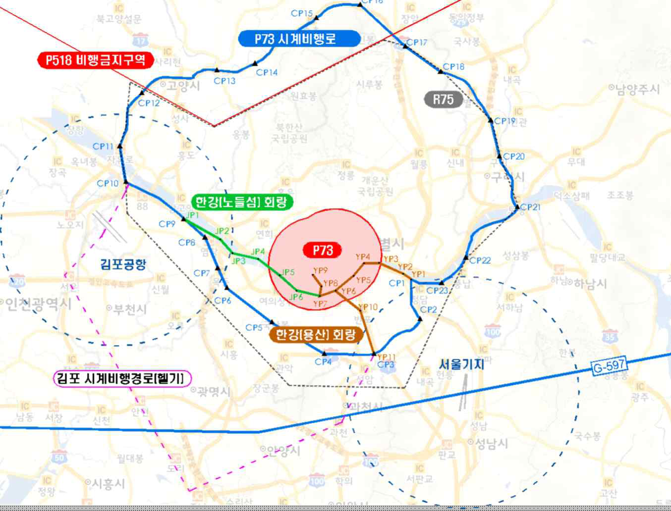
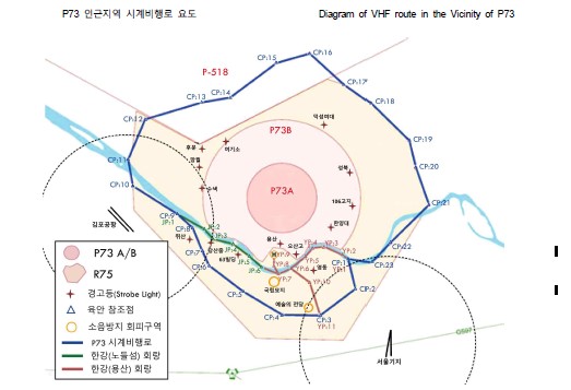
|
Ref Points |
Place |
|---|---|
|
CP - 1 |
Midpoint of Cheongdam Bridge |
|
CP - 2 |
Daechi Bridge |
|
CP - 3 |
Gyeongbu Expressway Yangjaecheon Bridge |
|
CP - 4 |
Quarry |
|
CP - 5 |
Hill 180 |
|
CP - 6 |
Yeongdeungpo station Yeongdeungpo Station |
|
CP - 7 |
Mokdong Bridge |
|
CP - 8 |
Yeomchang Bridge |
|
CP - 9 |
South end of Gayang Bridge |
|
CP - 10 |
South end of Haengju Bridge |
|
CP - 11 |
North end of Gimpo Bridge |
|
CP - 12 |
Goyang IC |
|
CP - 13 |
Tongillo IC |
|
CP - 14 |
Yangju TG |
|
CP - 15 |
Songchu IC |
|
CP - 16 |
Peak of Sapae-san |
|
CP - 17 |
Uijeongbu IC |
|
CP - 18 |
Deokreung Bridge |
|
CP - 19 |
Toegyewon IC |
|
CP - 20 |
Guri IC |
|
CP - 21 |
North end of Gangdong Bridge |
|
CP - 22 |
Midpoint of Cheonho Bridge |
|
CP - 23 |
Midpoint of Jamsil Bridge |
Diagram of Han-gang Corridor
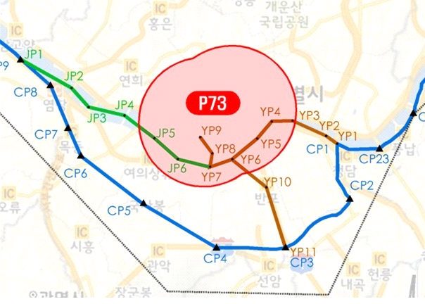
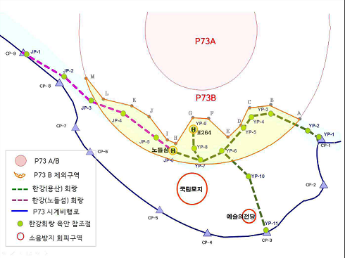
- Reference Points of P73A/B
|
A |
Gangbyen Highway |
|
B |
North end of Sungsu Bridge |
|
C |
North end of Dongho Bridge |
|
D |
North end of Hannam Bridge |
|
E |
Gangbyen Highway (Bogwangdong) |
|
F |
Intersection of Itaewon |
|
G |
Intersection of Samgakji |
|
H |
North end of Hangang Bridge |
|
I |
North end of Hangang Railway |
|
J |
North end of Mapo Bridge |
|
K |
North end of Seogang Bridge |
|
L |
North end of Yanghwa Bridge |
|
M |
North end of Sungsan Bridge |
- Reference Points of Han-gang Corridor
|
Ref Points |
Place |
|---|---|
|
YP - 1 (CP - 1) |
Midpoint of Cheongdam Bridge |
|
YP - 2 |
Midpoint of Yeongdong Bridge |
|
YP - 3 |
Midpoint of Seongsu Bridge |
|
YP - 4 |
Midpoint of Dongho Bridge |
|
YP - 5 |
Midpoint of Hannam Bridge |
|
YP - 6 |
Midpoint of Banpo Bridge |
|
YP - 7 |
Midpoint of Dongjak Bridge |
|
YP - 8 |
Square Chimney |
|
YP - 9 |
H-264 |
|
YP - 10 |
Banpo IC |
|
YP - 11 (CP - 3) |
Gyeongbu Expressway Yangjaecheon Bridge |
|
JP - 1 (CP - 9) |
South end of Gayang Bridge |
|
JP - 2 |
Midpoint of Seongsan Bridge |
|
JP - 3 |
Seonyu-do / Hill 17 |
|
JP - 4 |
Midpoint of Seogang Bridge |
|
JP - 5 |
Midpoint of Wonhyo bridge |
|
JP - 6 |
Nodulseom heliport |
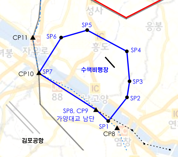
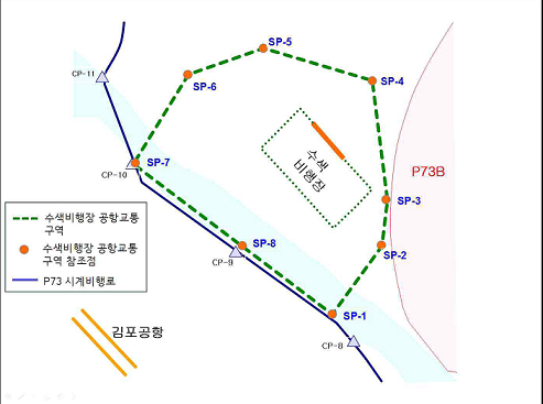
|
Ref Points |
Place |
|---|---|
|
SP - 1 |
Hill 55 |
|
SP - 2 |
Sangam-dong |
|
SP - 3 |
Intersection |
|
SP - 4 |
Mangwol |
|
SP - 5 |
Joint Pt of stream |
|
SP - 6 |
Intersection |
|
SP - 7 (CP - 10) |
South end of Haengju Bridge |
|
SP - 8 (CP - 9) |
South end of Gayang Bridge |
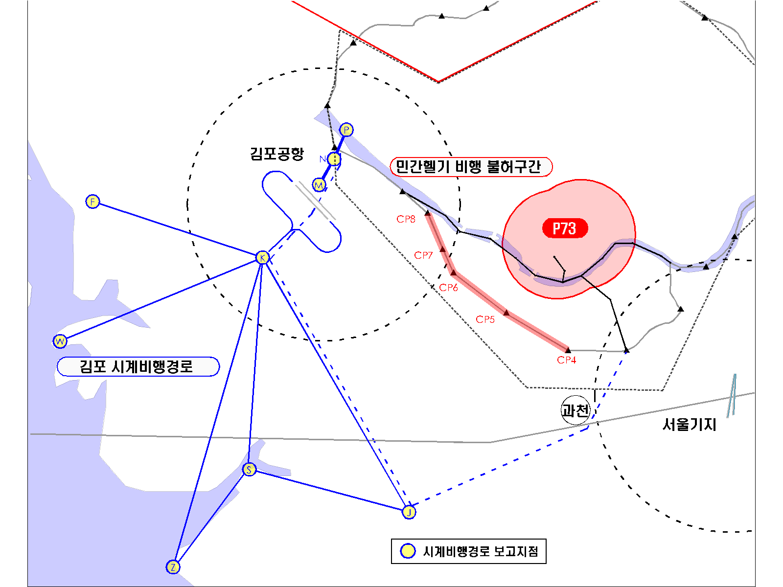
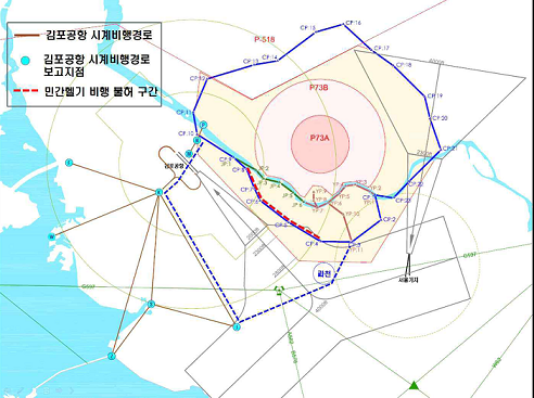
|
Ref Points |
Place |
|---|---|
|
F |
N. Incheon IC Buk-Incheon IC |
|
J |
Jonam JCT |
|
K |
Seoul JCT Seoun JCT |
|
M |
Farm Land north of Kimpo Airport North farmland of Gimpo airport |
|
N |
Gaehwa Mt. Gaehwa Hil |
|
R |
Hangjoo Br. Hangju Bridge |
|
S |
Sorae |
|
W |
Wolmi Island Wolmido |
|
Z |
Sihwa sea dike Sihwa Breakwater |
※ Details : Refer to Gimpo Airport Local Procedure (AIP. RKSS AD 2-30)
※ Details : Refer to Gimpo Airport Local Procedure (AIP RKSS AD 2-30)
|
Route |
Control Barrier |
Alt.(ft) ALT(ft) |
Section Alt. Section ALT |
|---|---|---|---|
|
CP-1 (Chungdam Br.) (Chungdam Bridge) ~ CP-3 (Yangjaechun Br. of Gyeongbu Hghwy.) (Gyeongbu Expressway Yangjaecheon Bridge) |
Hyundai I-Park |
659 |
Above 2 000 ft AMSL Above 2 000 ft AMSL |
|
COEX Tower |
749 | ||
|
Tower Palace |
867 | ||
|
CP-3 (Yangjaechun Br. of Gyeongbu Hghwy.) (Gyeongbu Expressway Yangjaecheon Bridge) ~ CP-4 (Quarry) |
Hyundai Superville |
535 |
2 000 ft AMSL ~ 1 000 ft AMSL |
|
Woomyeon Mt. |
967 | ||
|
CP-4(Quarry) ~ CP-5(Hill 180) |
Bongcheon Blooming |
Bldg : 221 Feature: : 373 = 594 |
Above 1 000 ft AMSL ※ Close to final approach course of Gimpo airport. (Caution Needed) ※ Operation under Gimpo Tower Control ※ Close to final approach course of Gimpo Airport. (Caution Needed) ※ Operation under Gimpo Tower Control. |
|
CP-5(Hill 180) ~ CP-6(Yeongdeungpo Station) |
Boramae Samsung Chereville |
535 | |
|
CP-6(Yeongdeungpo Station) ~ CP-7(Mokdong Bridge) |
SK Leader's View |
568 | |
|
CP-6(Yeong deungpo station) ~ CP-7(Mokdong Bridge) |
Yangcheon resource recovery chimney |
492 |
|
Route |
Control Barrier |
Alt.(ft) ALT(ft) |
Section Alt. Section ALT |
|---|---|---|---|
|
CP-8 (Yeomchang Br.) (Yeomchang Bridge) ~ CP-11 (N. end of Kimpo Br.) (North end of Gimpo Bridge) |
- |
- |
Above 1 500 ft AMSL ※ No particular barrier, some areas densely populated Above 1 500 ft AMSL ※ No particular barrier, some areas densely populated. |
|
- |
- | ||
|
CP-11 (N. end of Kimpo Br.) (North end of Gimpo Bridge) ~ CP-14 (Yangju TG) |
- |
- | |
|
- |
- |
|
Route |
Control Barrier |
Alt.(ft) ALT(ft) |
Section Alt. Section ALT |
|---|---|---|---|
|
CP-14 (Yangju TG) ~ CP-15 (Songchu IC) |
Nogo Mt. |
1 416 |
Above 2 500 ft AMSL Above 2 500 ft AMSL |
|
CP-16 (Pk. of Sapae Mt.) (Peak of Sapae-san) ~ CP-17 (Euijeongbu IC) (Uijeongbu IC) |
Sapae Mt. |
1 822 |
Above 2 800 ft AMSL Above 2 800 ft AMSL |
|
CP-17 (Euijeongbu IC) (Uijeongbu IC) ~ CP-19 (Taegaewon IC) (Toegyewon IC) |
Surak Mt |
2 112 |
Above 2 000 ft AMSL ※ Close to final approach course of Seoul AB (Caution Needed) (Above 2 800 ft in case aircraft approaching Seoul) ※ Mountainous /Caution Needed Above 2 000 ft AMSL ※ Close to final approach course of Seoul AB. (Caution Needed) (Above 2 800 ft in case aircraft approaching Seoul) ※ Mountainous /Caution Needed. |
|
Bulam Mt. |
1 683 |
|
Route |
Control Barrier |
Alt.(ft) ALT(ft) |
Section Alt. Section ALT |
|---|---|---|---|
|
CP-19 (Taegaewon TG) (Toegyewon IC) ~ CP-20 (Guri IC) |
- |
- |
1 500 ft AMSL 1 500 ft AMSL ※ Overlapped with final approach course of Seoul AB. (caution needed) |
|
CP-20 (Guri IC) ~ CP-21 (N. end of Gangdong br.) (North end of Gangdong Bridge |
Donong Majesty Tower |
Bldg : 413 Feature : 86 = 500 |
1 300 ft AMSL ※ overlapped with final approach course of Seoul AB (caution needed) 1 300 ft AMSL ※ Overlapped with final approach course of Seoul AB. (caution needed) |
|
CP-21 (N. end of Gangdong br) (North end of Gangdong Bridge) ~ CP-23 (midpoint of Jamsil Br.) (Midpoint of Jamsil Bridge) |
Technomart 21 |
623 |
800 ft AMSL ※ overlapped with final approach course of Seoul AB (caution needed) ※ Operation under Seoul Tower Control 800 ft AMSL ※ Overlapped with final approach course of Seoul AB. (caution needed) ※ Operation under Seoul Tower Control. |
|
Etc. (Airfield Replica) | |||
|
CP-23 (midpoint of Jamsil Br.) (Midpoint of Jamsil Bridge) ~ CP-1 (Midpoint of Chungdam Br.) (Midpoint of Cheongdam Bridge) |
- |
- |
Above 1 000 ft AMSL Above 1 000 ft AMSL |
|
Lotte Tower ※ Separation 5 100 ft from south of CP-23 |
1 281 |
Route | Control Barrier | ALT(ft) | Section ALT |
JP-1 (South end of Gayang Bridge) ~ JP-6 (Nodulseom heliport) ※ Nodeul Corridor | Parkone Bldg (373135N 1265538E) | 1 093 | Above 1 500ft AMSL ※ Skyscrapers and densely populated areas IVO Hangang. |
63 Building (373111N 1265624E) | 819 | ||
YP-1 (Midpoint of Cheongdam Bridge) ~ YP-7 (Midpoint of Dongjak Bridge) ※ Yongsan Corridor | Chungdam GS Xi At. | 462 |
Seoul Air Base VFR Reference Point, which overlaps with R75
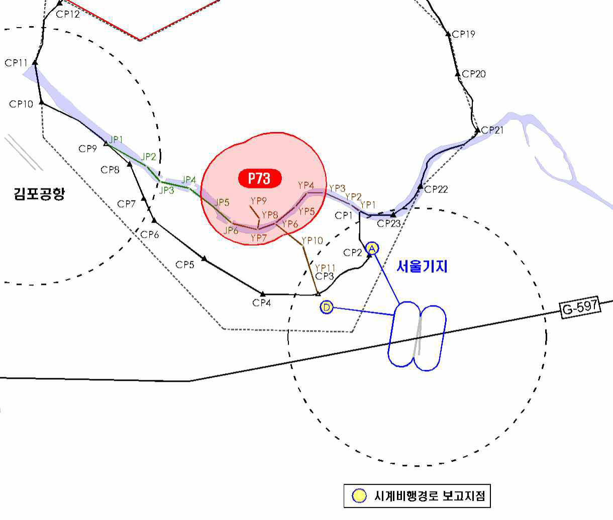
Name | Visual REF. | Coordinates |
'A' POINT | Tancheon Stream Sewage treatment plant | CG 305517 |
'D' POINT | Yangjae Interchange | CG 266481 |
|
Route |
Control Barrier |
Alt.(ft) ALT(ft) |
Section Alt. Section AL |
|---|---|---|---|
|
JP-1 (S. end of Gayang Br.) (South end of Gayang Bridge) ~ JP-6 (Midpoint of Dongjak Br.) (Nodulseom heliport) ※ Nodeul Corridor |
Parkone Bldg (373135N 1265538E) |
1 093 |
Above 1 500 ft AMSL ※ Skyscrapers and densely populated areas IVO Hangang Above 1 500ft AMSL ※ Skyscrapers and densely populated areas IVO Hangang. |
63 Building (373111N 1265624E) | 819 | ||
|
YP-1 (Midpoint of Chungdam Br.) (Midpoint of Cheongdam Bridge) ~ YP-7 (Midpoint of Dongjak Br.) (Midpoint of Dongjak Bridge) ※ Yongsan Corridor |
Chungdam GS Xi At. |
462 |