RKPK — Gimhae INTL
RKPK AD 2.1 AERODROME LOCATION INDICATOR AND NAME
RKPK - BUSAN / Gimhae International
RKPK AD 2.2 AERODROME GEOGRAPHICAL AND ADMINISTRATIVE DATA
| 1 |
ARP coordinates and site at AD |
351050N 1285617E 004° / 1 706 M from THR 36L. |
| 2 |
Direction and distance from city |
277° / 12 KM from Busan City Hall |
| 3 |
Elevation/Reference temperature |
4 M / 31.5 °C |
| 4 |
Geoid undulation at AD ELEV PSN |
29 M |
| 5 |
Magnetic variation/Annual change |
8° W (201 5 ) / 0.0 73° increasing |
| 6 |
Aerodrome Operator, Address, Telephone, Telefax, AFS |
Post:
Busan Regional Office of Avi ation Ministry of Land, Infrastructure and Transport. 108, Gonghangjinip-ro, Gangseo-gu, Busan, 618-702 Republic of Korea Tel: Tel : +82-51-974-2214∼5 Fax: Telefax : +82-51-974-2216 AFS: AFS : RKPKZPZX |
| 7 |
Types of traffic permitted(IFR/VFR) |
IFR/VFR |
| 8 |
Remarks |
Military Air Base |
RKPK AD 2.3 OPERATIONAL HOURS
| 1 |
Aerodrome Operator |
2100-1400 UTC |
| 2 |
Customs and Immigration |
HO |
| 3 |
Health and sanitation |
HO |
| 4 |
AIS Briefing Office |
H24 |
| 5 |
ATS Reporting Office |
H24 |
| 6 |
MET Briefing Office |
H24 |
| 7 |
ATS |
H24 |
| 8 |
Fuelling |
HO |
| 9 |
Handling |
HO |
| 10 |
Security |
HO |
| 11 |
De-icing |
2000-1400 UTC |
| 12 |
Remarks |
RKPK AD 2.4 HANDLING SERVICES AND FACILITIES
| 1 |
Cargo-handling facilities |
Available by arrangement |
| 2 |
Fuel/oil types |
Jet A-1 Oil : ESS0-2380 / TURBO-750 / 274MIL5606. |
| 3 |
Fuelling facilities/capacity |
Jet A-1 available by hydrant refueling on passenger and cargo apron, at rate of 1 000 gpm. 4 Aircraft can be fueled simultaneously, total amount of storage is 6 201 000 liters. No limitation at any time service available. |
| 4 |
De-icing facilities |
Available. Location of de-icing pad : G8 Taxiway, G9 Taxiway , Aircraft Stand 26, Aircraft Stand 27 |
| 5 |
Hangar space for visiting aircraft |
NIL |
| 6 |
Repair facilities for visiting aircraft |
NIL |
| 7 |
Remarks |
NIL |
RKPK AD 2.5 PASSENGER FACILITIES
| 1 |
Hotels |
Near AD and in Busan city |
| 2 |
Restaurants |
At AD and in Busan city |
| 3 |
Transportation |
Light rail, Buses, Taxies, and rental cars available at AD |
| 4 |
Medical Facilities |
|
| 5 |
Bank and Post Office |
Available at AD |
| 6 |
Tourist Office |
Available at AD |
| 7 |
Remarks |
http://www.airport.co.kr/mbs/gimhae/ |
RKPK AD 2.6 RESCUE AND FIRE FIGHTING SERVICES
| 1 |
AD Category for fire fighting |
Category 9 |
| 2 |
Rescue equipment |
|
| 3 |
Capability for removal of disabled aircraFT |
Specialized aircraft recovery equipment available for up to and including B747-400 size aircraft. 100ton hydraulic recovery jack, 330 ton crane and other accessory equipment can be provided by airlines and agencies. Korea Airports Corporation is the co-ordinator for the removal of disabled aircraft and can be reached at Tel +82-51-974-3411, Airport Duty Manager. |
| 4 |
Remarks |
* Aqueous Film Forming Foam (AFFF). |
RKPK AD 2.7 SEASONAL AVAILABILITY-CLEARING
| 1 |
Type of clearing equipment |
|
| 2 |
Clearance priorities |
|
| 3 |
Remarks |
Snow clearance information promulgated by SNOWTAM. * Republic of Korea Air Force(ROKAF). ** Korea Airports Corporation(KAC). |
RKPK AD 2.8 APRONS, TAXIWAYS AND CHECK LOCATIONS / POSITION DATA
| 1 |
Designation, Apron surface and strength |
|
||||||||||||||||||||||||||||||||||||||||||||||||||
| 2 |
Designation, Taxiway width, surface and strength |
|
||||||||||||||||||||||||||||||||||||||||||||||||||
| 3 |
Altimeter checkpoint location and elevation |
All Aprons / 2 m (8 ft) |
||||||||||||||||||||||||||||||||||||||||||||||||||
| 4 |
VOR checkpoints |
VOR : NIL |
||||||||||||||||||||||||||||||||||||||||||||||||||
| 5 |
INS checkpoints |
INS : Every specified aircraft stands (Refer to Aircraft Parking/Docking Chart) |
||||||||||||||||||||||||||||||||||||||||||||||||||
| 6 |
Remarks |
Military Run-up area exits on TWY E1 and E5 |
RKPK AD 2.9 SURFACE MOVEMENT GUIDANCE AND CONTROL SYSTEM AND MARKINGS
| 1 |
Use of aircraft stand ID signs, TWY guide lines and visual docking/parking guidance system of aircraft stands |
|
| 2 |
RWY and TWY markings and LGT |
|
| 3 |
Stop bars |
Refer to Aerodrome Ground Movement Chart (AD Chart 2-5/2-6) |
| 4 |
Remarks |
NIL |
RKPK AD 2.10 AERODROME OBSTACLES
| In Area 2 |
|||||
| OBST ID/ Designation |
OBST type |
OBST position |
ELEV/HGT |
Markings/ Type, colour |
Remarks |
| a |
b |
c |
d |
e |
f |
| RKPKOB001 |
Tree |
350930.1N 1285620.9E |
57 ft/ |
NIL |
36L/R APCH 18L/R TKOF |
| RKPKOB002 |
Hill |
351438.3N 1285331.0E |
1 077 ft/ |
NIL |
|
| RKPKOB003 |
Hill |
351516.5N 1285320.4E |
1 312 ft/ |
NIL |
|
| RKPKOB004 |
Hill |
350430.2N 1285800.9E |
590 ft/ |
NIL |
|
| RKPKOB005 |
Hill |
350357.2N 1285808.9E |
768 ft/ |
NIL |
|
| RKPKOB006 |
Hill |
351455.9N 1285523.8E |
1 333 ft/ |
NIL |
|
| RKPKOB007 |
Hill |
350701.7N 1285825.4E |
1 115 ft/ |
NIL |
|
| RKPKOB008 |
Hill |
351100.3N 1290118.8E |
2 107 ft/ |
NIL |
|
| RKPKOB009 |
Antenna |
350924.5N 1285643.1E |
73 ft/ |
NIL |
|
| RKPKOB010 |
Hill |
350700.7N 1285832.8E |
1 377 ft/ |
NIL |
|
| RKPKOB011 |
Hill |
351455.9N 1285523.8E |
1 345 ft/ |
NIL |
18L/R APCH 36L/R TKOF |
| RKPKOB012 |
Hill |
351140.2N 1285405.8E |
197 ft/ |
NIL |
In 18L/R circling area and at AD |
| RKPKOB013 |
Hill |
351353.9N 1285541.9E |
656 ft/ |
NIL |
|
| RKPKOB014 |
Hill |
351148.9N 1285457.1E |
132 ft/ |
NIL |
|
| In Area 3 |
|||||
| OBST ID/ Designation |
OBST type |
OBST position |
ELEV/HGT |
Markings/ Type, colour |
Remarks |
| a |
b |
c |
d |
e |
f |
| NIL |
|||||
| Remarks |
|||||
|
|||||
RKPK AD 2.11 METEOROLOGICAL INFORMATION PROVIDED
| 1 |
Associated MET Office |
Gimhae Airport Weather Office (Tel : +82-51-941-0365, Fax : +82-51-941-0366) |
| 2 |
Hours of service MET Office outside hours |
24 hours - |
| 3 |
Office responsible for TAF preparation Periods of validity |
ROKAF(Republic of Korea Airforce) MET Office 30 hours at 0000, 0600, 1200, 1800 UTC |
| 4 |
Trend forecast Interval of issuance |
|
| 5 |
Briefing/consultation |
|
| 6 |
Flight documentation Language(s) used |
Aerodrome forecasts (TAF code form), SIGWX charts, WINTEM charts, SIGMET information in English |
| 7 |
Charts and other information available for briefing or consultation |
Analysis charts (surface and upper air), Prognostic charts, Graphic displays and other model outputs |
| 8 |
Supplementary equipment available for providing information |
Satellite and Weather radar imageries |
| 9 |
ATS units provided with information |
FIC, TWR and APP |
| 10 |
Additional informaton (limitation of service, etc.) |
All observation data, model outputs and forecasts produced byKMA and WAFS are available at the office through internet link.Apron Automated Meteorological Observing System(AMOS)equipment unserviceable.TOWER or APPROACH control AMOS information available. |
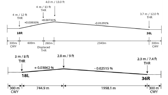
RKPK AD 2.12 RUNWAY PHYSICAL CHARACTERISTICS
| Designations RWY NR |
TRUE BRG |
Dimension of RWY(M) |
Strength(PCN) and surface of RWY and SWY |
THR coordinates RWY end coordinates THR geoid undulation |
THR elevation and highest elevation of TDZ of precision APP RWY |
|||||||||||||||||||||||||||||||||||
|---|---|---|---|---|---|---|---|---|---|---|---|---|---|---|---|---|---|---|---|---|---|---|---|---|---|---|---|---|---|---|---|---|---|---|---|---|---|---|---|---|
| 1 |
2 |
3 |
4 |
5 |
6 |
|||||||||||||||||||||||||||||||||||
| 18R |
173.95° |
3200 × 60 m |
PCN 62/R/B/W/T Concrete |
351137.94N 1285606.46E GUND 29 m |
THR 4 m / 12 ft |
|||||||||||||||||||||||||||||||||||
| 18R (Displaced) |
173.95° |
2600 × 60 m |
PCN 62/R/B/W/T Concrete |
351118.58N 1285608.96E GUND 29 m |
THR 4 m / 13 ft |
|||||||||||||||||||||||||||||||||||
| 36L |
353.95° |
3200 × 60 m |
PCN 62/R/B/W/T Concrete |
350954.69N 1285619.79E GUND 29.2 m |
THR 3.7 m / 12.0 ft TDZ 3.8 m / 12.5 ft |
|||||||||||||||||||||||||||||||||||
| 18L |
173.95° |
2743 × 46 m |
PCN 81/R/C/W/T Concrete |
351138.60N 1285614.73E - - |
THR 3 m / 8 ft |
|||||||||||||||||||||||||||||||||||
| 36R |
353.95° |
2743 × 46 m |
PCN 81/R/C/W/T Concrete |
351010.10N 1285626.14E - - |
THR 2.3 m / 7.4 ft TDZ 2.5 m / 8.2 ft |
|||||||||||||||||||||||||||||||||||
| 7. Slope of RWY-SWY |
||||||||||||||||||||||||||||||||||||||||
|
||||||||||||||||||||||||||||||||||||||||
|
||||||||||||||||||||||||||||||||||||||||
RKPK AD 2.13 DECLARED DISTANCES
| RWY Designator |
TORA (M) |
TODA (M) |
ASDA (M) |
LDA (M) |
Remarks |
|---|---|---|---|---|---|
| 1 |
2 |
3 |
4 |
5 |
6 |
| 18R |
3 200 |
3 500 |
3 200 |
2 600 |
18R Landing threshold is displaced by 600 m |
| 18R |
2 408 |
2 708 |
2 408 |
- |
Take-off from intersection with TWY C2 |
| 36L |
3 200 |
3 500 |
3 200 |
3 200 |
NIL |
| 36L |
2 743 |
3 043 |
2 743 |
- |
Take-off from intersection with TWY C7 |
| 18L |
2 743 |
3 043 |
2 743 |
2 743 |
NIL |
| 18L |
2 256 |
2 556 |
2 256 |
- |
Take-off from intersection with TWY E2 |
| 36R |
2 743 |
3 043 |
2 743 |
2 743 |
NIL |
RKPK AD 2.14 APPROACH AND RUNWAY LIGHTING
| RWY Designator |
APCH LGT type LEN INTST |
THR LGT Colour WBAR |
VASIS (MEHT) PAPI |
TDZ LGT LEN |
RWY Centerline LGT Length, Spacing, Colour, INTST |
RWY edge LGT LEN Spacing Colour INTST |
RWY End LGT Colour WBAR |
SWY LGT LEN(M) Colour |
|---|---|---|---|---|---|---|---|---|
| 1 |
2 |
3 |
4 |
5 |
6 |
7 |
8 |
9 |
| 18R |
SSALF 420 m LIH |
Green - |
PAPI* Both/3° 58 ft |
NIL |
3 200 m 15 m White/Red LIH |
3 200 m 30 m White LIH |
Red - |
NIL |
| 36L |
ALSF-II 900 m LIH |
Green - |
PAPI Left/3° 60 ft |
900 m |
3200 m 15 m White/Red LIH |
3200 m 30 m White LIH |
Red - |
NIL |
| 18L |
SSALR 720 m LIH |
Green - |
PAPI* Both/3° 58 ft |
NIL |
2743 m 15 m White/Red LIH |
2743 m 30 m White LIH |
Red - |
NIL |
| 36R |
ALSF-II 900 m LIH |
Green - |
PAPI Both/3˚ 60 ft |
900 m |
2743 m 15 m White/Red LIH |
2743 m 30 m White LIH |
Red - |
NIL |
| 10. Remarks:
|
||||||||
RKPK AD 2.15 OTHER LIGHTING, SECONDARY POWER SUPPLY
| 1 |
ABN/IBN location, characteristics and hours of operation |
ABN : At Hangar Building, FLG W/W-G (16~20 FPM*) / IBN : NIL Hours of Operation : H24 *FPM : Flash Per Minute |
| 2 |
LDI location and LGT Anemometer location and LGT |
LDI : NIL |
| 3 |
TWY edge and center line lighting |
Edge: All TWY Center line: All TWY EXC W1, W2, W3 |
| 4 |
Secondary power supply/swithch-over time |
Secondary power supply to all lighting at AD Switch-over time : 1 or 15 SEC according to kind of lights (Complied with ICAO requirements) |
| 5 |
Remarks |
NIL |
RKPK AD 2.16 HELICOPTER LANDING AREA
| 1 |
Coordinates TLOF or THR of FATO Geoid undulation |
- |
| 2 |
TLOF and/or FATO elevation M/FT |
- |
| 3 |
TLOF and FATO area dimesions, surface, strength and marking |
- |
| 4 |
True BRG of FATO |
- |
| 5 |
Declared distance available |
- |
| 6 |
APP and FATO lightng |
- |
| 7 |
Remarks |
As directed by ATC |
RKPK AD 2.17 ATS AIRSPACE
| 1 |
Designation and lateral limit |
Gimhae CTR A circle, 5 NM radius centered at ARP. |
| 2 |
Vertical limits |
SFC to 3000 ft AGL |
| 3 |
Airspace classification |
C |
| 4 |
ATS unit call sign Language |
Gimhae Tower English / Korean |
| 5 |
Transition altitude |
14 000 ft AMSL |
| 6 |
Operational Hours |
H24 |
| 7 |
Remarks |
NIL |
RKPK AD 2.18 ATS COMMUNICATION FACILITIES
| Service designation |
Call sign |
Channel |
Hours of operation |
Remarks |
|---|---|---|---|---|
| 1 |
2 |
3 |
4 |
5 |
| APP |
Gimhae Approach |
125.5 MHz 225.1 MHz |
H24 |
NIL |
| ARP |
Gimhae Arrival |
119.2 MHz 230.1 MHz 134.4 MHz 253.8 MHz |
H24 |
NIL |
| DEP |
Gimhae Departure |
125.5 MHz 363.8 MHz |
H24 |
NIL |
| TWR |
Gimhae Tower |
118.1 MHz 233.3 MHz 118.450 MHz 236.6 MHz |
H24 |
NIL |
| GND |
Gimhae Ground |
121.9 MHz 275.8 MHz |
H24 |
NIL |
| DLVRY |
Gimhae Delivery |
121.8 MHz 229.525 MHz |
H24 |
USE MILITARY AIRCRAFT AND AIRCRAFT FOR KOREAN AIR PDM(Programmed Depot Maintenance) |
| ATIS |
Gimhae INTL Airport |
126.6 MHz 235.1 MHz |
2000-1400 UTC |
Digital ATIS service available |
| APRON |
Gimhae Apron Gimhae Delivery |
121.65 MHz 317.450 MHz 121.725 MHz | H24 |
* USE CIVIL AIRCRAFT * CIVIL APRON DIGITAL PDC SERVICE AVAILABLE |
| EMERG |
121.5 MHz 243.0 MHz |
H24 |
NIL |
|
| Scheduled Inspection Time : - ARR (119.2 MHz), DEP, TWR, GND, DLVRY, ATIS, APRON and EMERG : Every 1st and 3rd TUE(1400-1800 UTC) of the month. |
||||
RKPK AD 2.19 RADIO NAVIGATION AND LANDING AIDS
| Type of aid, MAG VAR, Type of supported OPS |
ID |
Frequency |
Hours of operation |
Position of transmitting antenna coordinates |
Elevation of DME transmitting antenna |
Remarks |
|---|---|---|---|---|---|---|
| 1 |
2 |
3 |
4 |
5 |
6 |
7 |
| LOC 36L ILS CAT II (8°W or 352°) |
IKMA |
108.5 MHz |
H24 |
351147. 6 N 1285605.2E |
- |
LOC unserviceable - Beyond 15° on East side |
| DME 36L |
983.0 MHz CH 22X |
H24 |
351 004 .8N 12856 13.6 E |
0 ft |
||
| GP 36L |
329.9 MHz |
H24 |
351004.8N 1285613.7E |
- |
3° ILS TCH 51.68 ft |
|
| IM 36L |
E |
75 MHz |
H24 |
350945.1N 1285621. 0 E |
- |
|
| LOC 36R ILS CAT I (8°W or 352°) |
IKHE |
109.5 MHz |
H24 |
351148.2N 1285613.5E |
- |
LOC unserviceable - Beyond 15° on East side |
| DME 36R |
993.0 MHz CH 32X |
H24 |
351021.3N 1285629.5E |
0 ft |
||
| GP 36R |
332.6 MHz |
H24 |
351021.3N 1285629.5E |
- |
3° ILS RDH 58 ft |
|
| VOR/DME |
KMH |
113.8 MHz (CH 85X) |
H24 |
351156.9N 1285608.2E (VOR) 351156.9N 1285607.7E (DME) |
0 ft |
VOR unserviceable - RDL 000-013 beyond 20 NM BLW 7 500 ft - RDL 052-069 beyond 22 NM BLW 7 000 ft - RDL 080-120 beyond 21 NM BLW 7 000 ft - RDL 346-360 beyond 20 NM BLW 7 500 ft - RDL 100-160 beyond 20 NM Due to KLIZ |
| VORTAC |
PSN |
114.0 MHz (CH 87X) |
H24 |
350721N 1285958E |
1 900 ft |
Unserviceability and Scheduled Inspection time: See ENR 4.1-1 for the details |
| Scheduled Inspection time
|
||||||
RKPK AD 2.20 LOCAL AERODROME REGULATIONS
1 Airport regulation
-
1) Gimhae International airport is jointly operated by MOLIT and ROKAF. All aircraft that wish to use this AD have to observe the Gimhae Airport Local Regulations. Information about local regulation can be obtained from the TWR (ROKAF*) and Aeronautical Information Service Office (MOLIT**).
* ROKAF : Republic of Korea Air Force.
** MOLIT : Ministry of Land, Infrastructure and Transport.
-
2 ) All aircraft should taxi at speeds of less than 20 kt on Taxiway P to ensure safety. But ATC should order more than 20 kt for traffic flow management.
-
3 ) GIMHAE Airport Runway strip is not satisfied with ICAO Safety standard at the moment. Therefore, refer to the following advice for the aviation safety. If the value of the surface friction measurements is less than 0.2, refrain from the aircraft operation.
-
4 ) All jet aircraft with code letter “C” shall follow the dotted lead-in line for the stand 31 or 37.
-
5 ) All aircraft except jet aircraft with code letter “C” shall follow the dotted lead-in line for the stand 41.
6) Flight limitations
-
The use of airport for training purpose is prohibited. The deliberate simulation of engine failure is not permitted whilst on approach to or departure from the airport. 훈련목적의 공항 사용은 금지된다. 김해공항으로 접근 또는 출발시 엔진failure와 같은 고의적인 모의훈련은 허가되지 않는다.
-
The use of this airport by light sports aircraft, ultra-light vehicles and lighter than air is prohibited. 경량항공기, 초경량비행장치 및 기구 사용은 김해공항에서 금지된다.
-
2 Apron control services
3 Departure Procedure
Departing IFR flights shall contact GIMHAE Delivery(121.725 MHz) to obtain ATC clearance at least 5 minutes prior to push back.
-
-
Call sign
-
Gate or stand number
-
Release time(if necessary)
-
-
2) Ground crews (Ground handler, aircraft maintenance) must ensure that the area behind the aircraft shall be clear of vehicles, equipment and other obstructions prior to engine start-up or aircraft push back for smooth and safety aircraft movements
-
4) All aircraft to be taxied within the Apron shall fix their engine thrust on an Idle. In case of using breakaway thrust, it should be used to a minimum.
-
5) The following table describe the procedures for the pushback of aircraft from the various aircraft stands. When it becomes necessary to vary a procedure to expedite aircraft movements, GIMHAE APRON CONTROL will specify instructions to the pilot.
Aircraft
stands
Pushback Procedures
Phraseology
1 - 10,
19 - 29
The aircraft shall be pushed back to face south (or north)
Push back approved,
to face south (or north)
11
The aircraft shall be pushed back till its nosewheel is at the
start point 4 (or pushed back to face north)
Push back approved,
to start-point 4(or to face north)
41
The aircraft shall be pushed back and towing forward till its nosewheel is at the start point 1
Push back approved, to
start-point 1
12,
31 - 38,
42 - 48
The aircraft shall be pushed back till its nosewheel is at the intersection of lead-in line and taxi lane
Push back approved
52, 55
The aircraft shall be pushed back till its nosewheel is at the start point 2(or 3)
Push back approved, to start-point 2(or 3)
53, 54
The aircraft shall be pushed back till its nosewheel is at the start point 2
Push back approved, to start-point 2
51, 58
The aircraft shall be pushed back till its nosewheel is at the start point 3
Push back approved, to start-point 3
57
The aircraft shall be pushed back till its nose-tip is crossed east
side of GSE road and faces west
Push back approved, to face
west
-
Unles otherwise instructed, aircraft should use the folowing routes:
Apron
RWY in use
Route
Apron FREQ
R.T.P
Ground FREQ
Fixed wing
HEL
Fixed wing
HEL
Domestic, International 1 and 2
36L
G8, G11
G7, G11
121.65 MHz 317.45 MHz
G8(hold line), G11(hold line)
G7(hold line), G11(hold line)
121.9 MHz 275.8 MHz
36R
G8, G10
G8(hold line), G10(hold line)
18L
G7, G9
G7(hold line), G9(hold line)
18R
G7, G9
G7(hold line), G9(hold line)
Unless otherwise instructed, aircraft should use the following routes:
-
- RWY 36L in use : Apron - P - S or E5 - C7
-
- RWY 36R in use : Apron - P - E5
-
- RWY 18L in use : Apron - P - E1
-
- RWY 18R in use : Apron - P - E1 - C1
-
- When necessary, aircraft obtained intersection take-off clearance from the TWR may proceed to RWY through Central taxiway
-
- Aircraft standing on KAL parking area (PDM) located in the west part of AD shall proceed to RWY through "W2" or "W3" taxiway.
4 Deicing Operations
-
- Deicing Pad is located on G8, G9(Enable up to B-747), Aircraft stand 26 and Aircraft stand 27.
-
- Deicing Pad Operation
-
ㆍAircraft Operator has to notice to the Ground Operator When he/she wants to use Deicing Pad.
-
ㆍGround Operator has to notice to the relevant government as Operation Procedure.
-
-
- Deicing Pad Movement
-
ㆍAircraft Operator has to maintain a communication system which is connecting with Deicing Working.
-
5 Arrival Procedure
Unless otherwise instructed, aircraft should use the following routes:
-
- RWY 36L in use : C1 - E1 - P - APRON / C2 - E2 - P - APRON
-
- RWY 36R in use : E1 - P - APRON / E2 - P - APRON
E3 - P - APRON
-
- RWY 18L in use : E4 - P - APRON / E5 - P - APRON
-
- RWY 18R in use : C5 - E4 - P - APRON / C6 - E5 - P - APRON
C7 - E5 - P - APRON / S - P - APRON
-
- When necessary, other taxiway can be used under TWR permission.
-
Unless otherwise instructed, aircraft should use the following routes:
Apron
RWY in use
Route
Ground FREQ
R.T.P.
Apron FREQ
Fixed wing
HEL
Fixed wing
HEL
Domestic, International 1 and 2
36L
G7, G10
G7, G11
121.9 MHz
275.8 MHz
G7(hold line), G10(hold line)
G7(hold line), G11(hold line)
121.65 MHz 317.45 MHz
36R
G7, G9
G7(hold line), G9(hold line)
18L
G10
G10(hold line)
18R
G10
G10(hold line)
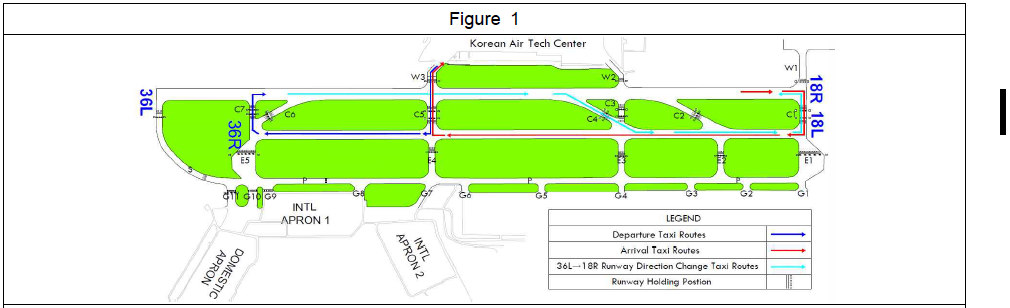
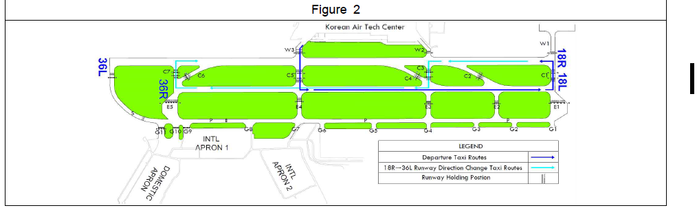
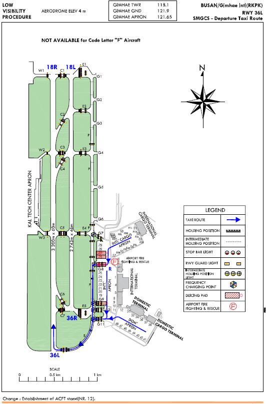
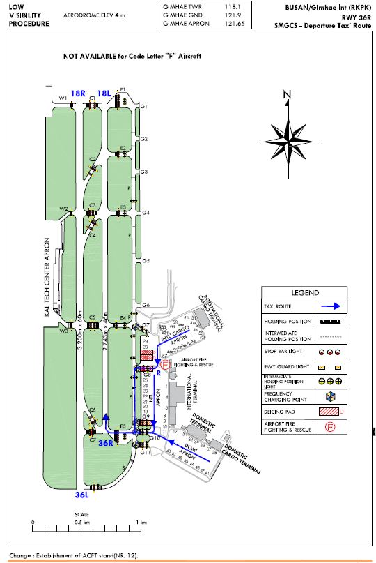
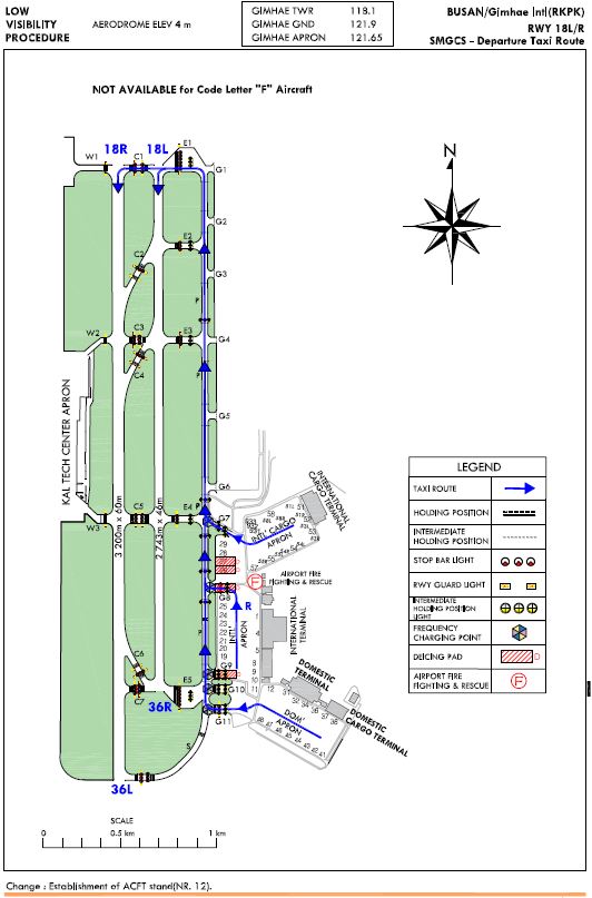
6 T he code letter F aircraft ferry flight operation procedure into Korean Air Tech-Center
-
DEPARTURE
- RWY 36L in use : Korean Air TECH CENTER → W3 → C5 → RWY 36R/18L → C7(See Figure 1)
- RWY 18R in use : Korean Air TECH CENTER → W3 → C5 → RWY 36R/18L → C1(See Figure 2)
* In case of Departure RWY changed while lining up on RWY
- RWY 36L in use : RWY 18R → C3 → RWY 36R/18L → C7(See Figure 2)
- RWY 18R in use : RWY 36L → C4 → RWY 36R/18L → C1(See Figure 1)
-
ARRIVAL
- RWY 36L in use : C1 → RWY 36R//18L → C5 → W3 → Korean Air TECH CENTER
- RWY 18R in use : N/A
-
1) Operation of T he code letter F aircraft is only permitted for ferry flight into Korean Air Tech-Center(Maintenance facility).
Carrying passenger or cargo is prohibited.
-
2) For the code letter F aircraft , Circling approach to RWY 18L/R is not permitted .
-
3) When T he code letter F aircraft takes off or lands on RWY 36L/18R , RWY 36R/18L is used as an alternative taxiing route.
-
4) T he code letter F aircraft Taxiing limitation
-
While operating , pilot shall use a digital auto - land ing or flight direction guidance system to monitor and control t he operation
-
While taxiing, The code letter F aircraft shall maintain ground speed at or below 10 knots, and set engines as follow :
DEPARTURE AND ARRIVAL : Set No. 1 and 4 engines on IDLE
-
While taxiing, The code letter F aircraft shall not be permitted to hold short of RWY. Otherwise, It is not be permitted to land on the RWY for any other aircraft .
-
T he code letter F aircraft shall follow the designated taxiing route .
-
7 Ground engine check procedure
-
Call sign or registration number
-
Stand number
-
Type of request, engine start or performance check
Engine start is permitted in the APRON areas. However, the power setting(s) shall not exceed idle thrust.
8 Helicopter Ground Operations
-
Use caution to vehicles or people on the nearby GSE road during entering a helicopter stand.
-
Only wheel-type helicopter could use a helicopter stand. Skid-type helicopter needs to contact the airport
operator before using an aircraft stand
without operating an engine)
-
Simultaneous operations with a nearby helicopter stand
-
While an helicopter is entering into a nearby helicopter stand
-
While following ground handing services are in progress in a nearby aircraft stand
-
Re-fueling
-
(Dis)embarkment of passenger
-
(Dis)embarkment of freeight
-
-
While push-back is an progress for an aircraft in stand 58L
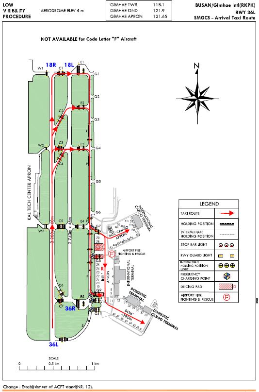
Gimhae International Airport RWY 36L has ILS CAT II equipments.
Low visibility Procedures are established for operation in a visibility of less than RVR 550 m or a cloud ceiling of less than 60 m (200 ft).
-
Low visibility operations will be initiated by broadcasting "ATC LOW VISIBILITY PROCEDURES ARE IN OPERATION" via ATIS and/or appropriate radio frequencies.
-
Low visibility operations will be terminated by deleting the above mentioned message from ATIS and/or broadcasting "ATC LOW VISIBILITY OPERATIONS ARE TERMINATED" via appropriate frequencies.
-
Approval for CAT II Operations
-
Aircraft operators and pilots who wish to conduct ILS CAT II operations at Gimhae International Airport shall conform with certain requirements. Details of these requirements are published in Aviation safety Act, Article 67 and its Enforcement regulations Article 189, which are available from :
Flight Operations Division Busan Regional Office of Aviation 108, Gonghangjinip-ro, Gangseo-gu, Busan, 46718, Republic of Korea
Tel : 82-51-974-2156~8 Fax : 82-51-971-1219
-
Foreign operators may obtain the approval from Administrator of Busan Regional Office of Aviation by providing the following information to Administrator of Busan Regional Office of Aviation
-
Aircraft type and register number;
-
The Category II minima under which they intend to operate; and
-
A copy of the category II certification issued by their own category authority.
-
-
-
Meteorological reports preclude ILS CAT I operations;
-
Low Visibility Procedures are in operation;
-
There is any unserviceability in a promulgated facility so that they may amend their minima.
General Special procedures and ground safeguards
Special procedures and ground safeguards will be applied during CAT II operations to protect the aircraft from operating in low visibility and to avoid interference with the ILS signals in accordance with the provisions of ICAO Doc. 9365 - Manual of All Weather Operations, and the provisions of the Enforcement Regulations of Aviation Safety Act, Article of 248.
-
Arriving Aircraft
-
Aircraft shall vacate the runway via the designated exit taxiways as follows :
RWY 36L - C1,C2,C3,C4,E1,E2,E3,P (Refer to RKPK AD 2-15)
-
Pilots are required to make a 'runway vacated' call, when entire aircraft has cleared the ILS critical sensitive areas.
-
-
Departing aircraft
aircraft shall normally enter the runway via the designated taxiways as follows :
RWY 36L - G8,G11,P,S (Refer to RKPK AD 2-16)
RWY 36R - G8,G10,P,E5 (Refer to RKPK AD 2-17)
RWY 18L - G7,G8,G11,P,E1 , RWY 18R - G7,G8,G11,P,E1,C1 (Refer to RKPK AD 2-18)
-
Unless otherwise cleared by ATC, all aircraft should be restricted to taxi within the apron in a visibility of less than RVR 350 m.
-
Refer to paragraph 6 of RKPK AD 2.20 for the taxi procedures of the code letter “F” ferry flight aircraft.
Pilots may carry out the practice of ILS CAT II approach at any time with a prior approval from ATC, but the full safeguarding ground procedures shall not be applied and pilots should anticipate the possibility of ILS signal interference.
RKPK AD 2.21 NOISE ABATEMENT PROCEDURES
1 Night Flight Restriction (Curfew) for noise abatement
All civil aircraft take-off and landing are restricted from 1400UTC to 2100UTC, For a dispensation to be granted, the following criteria would need to be satisfied in exceptional circumstances for an aircraft to operate during the curfew. Any applications for dispensation will be considered for 1.2 and 1.4 between 1400UTC and 1430UTC for the flight scheduled to depart from the airport before the start of the curfew period.
1.4 Re-screening of passengers and/or baggage for aviation security purpose.
2 Aircraft Operating Procedures(Except helicopter)
1) NADP 1(RWY 36)
All departing aircraft should apply ICAO PANS-OPS(Doc 8168) Volume I Noise Abatement Departing Procedures One(NADP ONE).
-
a) Thrust Reduction at 1 500 FT above aerodrome elevation is recommended.
-
b) Whenever practicable, all departing aircraft should climb with the aircraft's certified maximum climb gradient until reaching 3 000 FT AGL.
For noise abatement using a delayed/reduced flap setting landing procedure is recommended. However use of this procedure is subject to captain's decision and safety prevail at all times
-
1) Delayed/Reduced Flap setting Approach
All arriving aircraft shall apply the Delayed/ Reduced Flap setting approach as follows;
-
a) At IKHE/ IKMA 9 DME, lower gear, and,
-
b) While making ILS RWY 36R approach;
- Maintain intermediate flap setting until passing IKHE 8 DME.
- At IKHE 8 DME, set flap for landing.
-
c) While making ILS RWY 36L approach;
- Maintain intermediate flap setting until passing IKHE 8 DME.
- At IKHE 8 DME, set flap for landing.
-
-
2) Circling Approach RWY 18L/R
-
a) When conducting a circling approach to land RWY 18L/R, it is recommended that all aircraft avoid flying north of Namhae expressway for noise abatement except for aircraft in an emergency or in an unavoidable situation and helicopters.
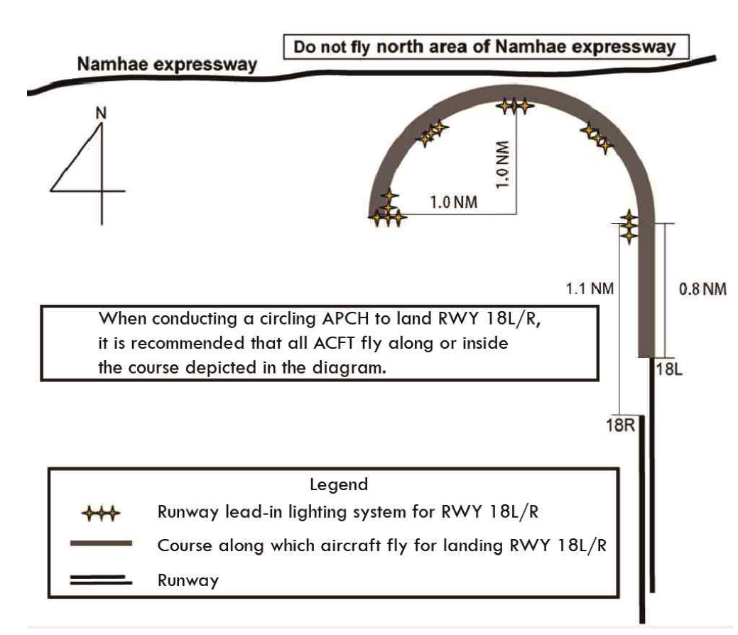
-
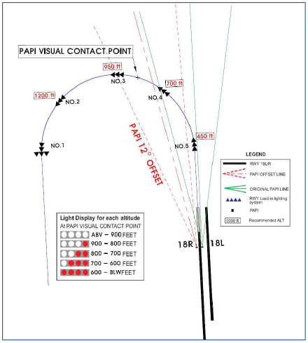
b) Display for RWY 18R PAPI Direction Adjustment Light
PAPI on the left of RWY 18R provides signals in the same direction of the RWY 18 extension line for ACFT on the final, but PAPI on the right of RWY 18R is offset by 12 degrees to the west for ACFT on the base leg in order to approach effectively.
-
landing RWY 36L except for operational or safety reasons
-
1) Aircraft unable to comply with the procedures described in paragraph 2.1 and 2.2 above for any reason should inform ATC.
-
2) Aircraft need not to be complied with the procedures described in paragraph 2.1 and 2.2 above in adverse operating conditions such as;
-
a) if the runway is not clear and dry. i.e. it is adversely affected by, snow, slush, ice, water or other substances;
-
b) in conditions when the ceiling is lower than 500 ft, or when the horizontal visibility is less than 1 900 m.
-
c) when the cross-wind component, including gusts, exceeds 15 kt.
-
d) when the tailwind component, including gusts, exceeds 5 kt.
-
e) when the wind shear has been reported or forecast, or thunderstorms are expected to affect the approach.
-
3 Runway Operation
-
Preferential runway
For noise abatement, landing onto or take-off from RWY 36L is recommended.
-
Intersection Take-off
Runway 18L/R Intersection take-off is recommended except in unavoidable cases for traffic flow or other reasons.
4 Operational Limitations
-
Engine run-up tests
-
a) Engine start is permitted in the apron areas only. However, the power setting(s) shall not exceed idle thrust.
-
b) Engine performance check is permitted in stand NR 45 or 46 only. But the aircraft shall start the check after repositioning to face North-East.
-
RKPK AD 2.22 FLIGHT PROCEDURES
1 IFR Procedure
| ENG |
RWY 18L/R |
RWY 36L/R |
For filling as Alternate |
|||
|---|---|---|---|---|---|---|
| Precision |
Non precision |
|||||
| 1 |
100 ft - 350 m |
A |
600 ft - 3 200 m |
800 ft - 3 200 m |
||
| 2 3 |
B |
|||||
| C |
||||||
| 4 |
D |
1 100 ft - 4 800 m |
||||
-
Area : A circle, radius 3 NM centered at R100 PSN/16 DME
-
Altitude
-
IFR aircraft : 6 000 ft AMSL
-
VFR aircraft : 4 000 ft AMSL
-
-
All aircraft shall not exceed 250 kt IAS below 10 000 ft AMSL in GIMHAE TMA, unless otherwise authorized by ATC. If the minimum safe speed is greater than 250 kt IAS, the aircraft may maintain the minimum safe speed without ATC authorization.
-
When ILS RWY 36L/R approach in use, civil aircraft should comply with following speed restrictions. if not to comply with speed restrictions, ATC may instruct speed restrictions.
-
Initial approach phase : 220 kt IAS or above
-
Base leg/Heading to final approach : 180 kt IAS - 220 kt IAS
-
Established on final approach to 8 DME : 160 kt IAS - 180 kt IAS
-
-
When ATC use “NO [ATC] SPEED RESTRICTIONS” RTF phraseology, pilot shall note that all speed control restrictions are cancelled and preferred speed may be flown without any speed restrictions.
-
When ATC use “RESUME NORMAL SPEED” RTF phraseology, pilot shall note that the previously issued speed restriction by ATC is cancelled but comply with GIMHAE TMA speed restriction(MAX 250 kt IAS below 10 000 ft).
2 VFR Procedure
-
VFR weather minimum
-
Ground visibility : Not less than 3 SM
-
Flight visibility : Not less than 5 SM
-
Ceiling : At or above 2 500 ft
-
-
VFR weather minimum for special mission helicopter
-
Ground visibility : 2 SM
-
Ceiling : 1 000 ft
-
-
VFR Pattern Altitude
-
Helicopter : 600 ft
-
Conventional : 1 000 ft
-
Jet : 1 500 ft
-
-
Special VFR
-
In Gimhae international airport, a special VFR operation is not applied to all aircraft.
-
3 Radar Procedure
-
RWY 36L(Straight-in)
CAT
GS/TCH(FT)/RPI(FT)
DA(FT)/VIS(M)
DH(FT)
Ceiling(FT)
A, B
3.0°/57/1070
213/RVR550
VIS 800
200
200
C, D
213/RVR730
VIS 800
200
200
When TDZ/CL INOP, Increase CAT A, B RVR to 730 M.
When ALS INOP, VIS 1 200 M and RVR to 1 220 M.
-
MISSED APCH PROCEDURES
- At DH climb HDG 310 to 4 300 ft and directed by ATC.
- Missed APCH climb rate exceed 340 ft/NM.
-
4 RADIO COMMUNICATION FAILURE PROCEDURE
-
General
- No person may take off unless two-way radio communications can be maintained with the Air Traffic Control.
- On recognition of communication failure during flight, squawk 7600 and if necessary to ensure safe altitude, climb to Minimum Safe Altitude or above to maintain obstacle clearance. Then comply with following procedure.
-
VFR condition
If the failure to radio communication occurs in VFR conditions, or if VFR conditions are encountered after the failure, a pilot shall continue the flight under VFR and land as soon as practicable based on the runway in use.
-
IFR condition
If the failure occurs in IFR condition, or if the requirements specified in paragraph 2 of this section cannot be met, a pilot shall continue the flight according to the following procedures :
-
DEPARTURE
-
Under Pilot Navigation
Follow the SID with altitude/flight level assigned at the last ATC clearance received.
-
Under Radar Vectoring
1) Proceed by the direct route from the point of radio failure to the fix, route, or airway specified in the vector clearance;
2) In the absence of an assigned route, proceed by the route that ATC will advise through the forthcoming clearance; or
3) In the absence of an assigned route or a route that ATC will advise through the forthcoming clearance, proceed by the route filed in the flight plan; and
4) Maintain minimum enroute altitude(MEA) or the altitude/flight level cleared in the last ATC clearance received, whichever is higher, for 20 minutes; then
5) Continue the flight with altitude/flight level filed in the flight plan
-
-
ARRIVAL
-
Proceed to GEOJE IAF or NARAE IAF or GAYHA IAF or ZULBI IAF or PEDLO IAF whichever is nearer at the last assigned altitude or the minimum altitude of IAF whichever is higher and hold; then
-
Execute Instrument Approach as close as possible to the expect further clearance time (EFC) issued by ATC or estimated time of arrival (ETA) filed in the flight plan; and
-
Land, if possible, within 30 minutes after ETA or the last acknowledged EFC or ETA, whichever is later.
-
-
VFR flight which has experienced radio communication failure shall
- Squawk Mode 3/A code 7600, and
- When able to see light gun signal of control tower, follow that instruction
- If unable to see light gun signal of control tower, hold on downwind until ETA or for 10 minutes, whichever is linger, then
- Aircraft on west pattern should land on RWY in use
- Pilot shall use caution traffic landing and take-off from/to runways.
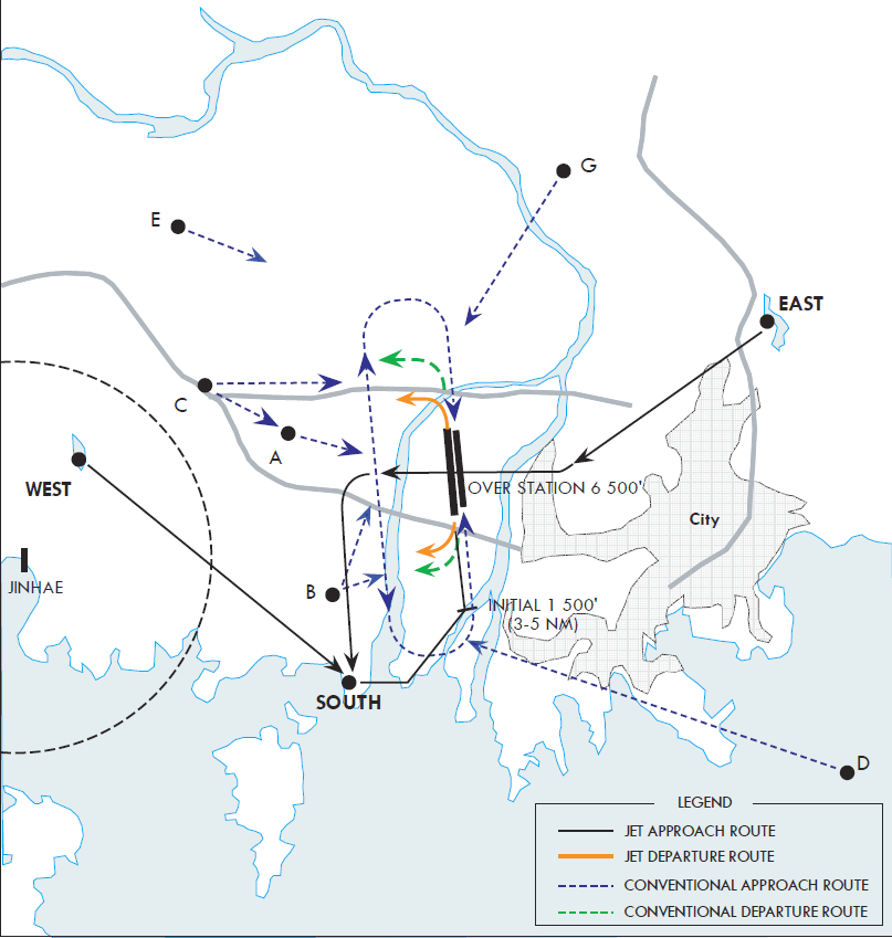
| Reporting Point |
Geographical Name |
Position |
Coordinates |
Remarks |
| A |
Distribution Center |
R 280 KHE/D5.0 R 269 KMH/D4.5 |
351119N 128° 50' 44'' E |
1 500 ft |
| B |
Noksan |
R 220 KHE/D5.8 R 212 KMH/D6.3 |
350611N 1285252E |
2 000 ft |
| C |
Naengjung |
R 293 KHE/D7.6 R 288 KMH/D6.9 |
351311N 1284752E |
IN : 2 500 ftOUT : 3 500 ft |
| D |
Taejongdae |
R 143 KHE/D10.8 R 145 KMH/D11.8 |
350311N 1290552E |
3 500 ft |
| E |
Jinyoung |
R 310 KHE/D12.0 R 305 KMH/D9.7 |
351711N 1284613E |
3 000 ft |
| G |
Mulgum |
R 020 KHE/D7.2 R 027 KMH/D6.6 |
351811N 1285852E |
3 000 ft |
| EAST |
Hoedong Reservoir |
R 072 KHE/D9.2 R 078 KMH/D9.4 |
351500N 1290700E |
6 500 ft |
| WEST |
Bulmosan Reservoir |
R 277 KHE/D11.2 R 273 KMH/D10.7 |
351105N 1284305E |
4 500 ft |
| SOUTH |
Shinhori |
R 219 KHE/D7.2 R 213 KMH/D7.7 |
350500N 1285205E |
3 500 ft |
RKPK AD 2.23 ADDITIONAL INFORMATION
-
The characteristics of Gimhae international airport
-
Topographical
Gimhae international airport is surrounded by mountains except the South part of the area.
-
Airspace
Pilots are required to keep strict aerial watch for following reasons ;
- Numerous helicopters flying between Jinhae airfield and US army airfield located in Busan city cross south of Gimhae international airport at any time.
(When necessary, traffic information and radar service are available at the pilot's request)
- Several Radio antennas are on the northwest of the airport.
-
Weather
- Due to seasonal wind conditions, RWY 36 is usually used in winter while RWY 18 in summer.
- Being adjacent to the sea, sea fog often occurs.
- When low level clouds much moves in the southwest of airport, the chance of rain gets higher.
-
Bird concentrations in the vicinity of airport
Due to bird habitats in airport, pilots shall exercise caution not to conflict with the birds.
- For one or two hours after sunrise, from January until march, and from October until December, birds like mallards fly from resting area (approximately 4~12 KM southwest of Runway 36L threshold) to feeding area (farmlands or airport).
Also, from April until September, during the same hours, birds which are mainly white-plumed egrets and grey herons move from resting area(mountains which are located in approximately 8 ~ 15 KM far from airport) to feeding area(farmlands or airport). Besides, resident birds, such as magpies and skylarks, sparrows, move in and out of agricultural area near the airport.
- The activity altitude of birds is from 0 to 2 000 FT (600 M). Also, before daily sunset, activities of the birds occur above the same way when returning to the resting area for one or two hours.
- Control tower shall offer pilots information about the birds's movement.
- Especially, during that time, control tower shall keep pilots informed that landing lights of aircraft are needed to turn on when take-off and approach for landing.
- Furthermore, preventive activities against bird strikes, such as operation of B.A.T (Bird Alert Team) and devices (cannon, shotgun, etc) which scare birds away, shall be carried out. Also, the measures for eliminating resting or feeding area of birds is being taken in the airport boundary, although insufficient. The measures are as followings : spraying plants with insecticide and eliminating waterway or puddle, improving methods of waste disposal from airport.
-
