RKNY — Yangyang
RKNY AD 2.1 AERODROME LOCATION INDICATOR AND NAME
RKNY - YANGYANG / International
RKNY AD 2.2 AERODROME GEOGRAPHICAL AND ADMINISTRATIVE DATA
| 1 |
ARP coordinates and site at AD |
380341N 1284009E 149° / 1 243 m from THR 15 |
| 2 |
Direction and distance from city |
093°, 4.4 km from Yangyang County office 162°, 16 km from Sokcho City Hall |
| 3 |
Elevation/Reference temperature |
73 m / 27.8°C |
| 4 |
Geoid undulation at AD ELEV PSN |
26 m |
| 5 |
MAG VAR/Annual change |
|
| 6 |
Aerodrome Operator, Address, Telephone, Fax, AFS |
Post:
Yangyang Airport Branch Office
Post:
(Seoul Regional Aviation Administration) 201, Gonghang-ro, Sonyang-meon, Yangyang-gun, Gangwon-do 25042, Republic of Korea Tel: Tel : +82-33-671-5855 Fax: Telefax : +82-33-670-7203 AFS: AFS : RKNYZPZX |
| 7 |
Types of traffic permitted(IFR/VFR) |
IFR/VFR |
| 8 |
Remarks |
NIL |
RKNY AD 2.3 OPERATIONAL HOURS
| 1 |
Aerodrome Operator |
2300 - 0900 UTC* |
| 2 |
Customs and Immigration |
HO |
| 3 |
Health and Sanitation |
HO |
| 4 |
AIS Briefing Office |
2300 - 0900 UTC* |
| 5 |
ATS Reporting Office |
2300 - 0900 UTC* |
| 6 |
MET Briefing Office |
2300 - 0900 UTC* |
| 7 |
ATS |
2300 - 0900 UTC* |
| 8 |
Fuelling |
2300 - 0900 UTC |
| 9 |
Handling |
2300 - 0900 UTC |
| 10 |
Security |
2300 - 0900 UTC |
| 11 |
De-icing |
HO |
| 12 |
Remarks |
* Outside these hours services are available on request (passenger flights only) |
RKNY AD 2.4 HANDLING SERVICES AND FACILITIES
| 1 |
Cargo-handling facilities |
Baggage Handling service only |
| 2 |
Fuel/oil types |
Jet A-1/Turbo 2380 |
| 3 |
Fuelling facilities/capacity |
Elevated storage tank 3 units/total 1 347 kilo liters 3 fuel tanks with 450 kilo liters Refueling available by trucks |
| 4 |
De-icing facilities |
NIL |
| 5 |
Hangar space for visiting aircraft |
NIL |
| 6 |
Repair facilities for visiting aircraft |
NIL |
| 7 |
Remarks |
NIL |
RKNY AD 2.5 PASSENGER FACILITIES
| 1 |
Hotels |
Near the AD and in the city (Yangyang & Sokcho) |
| 2 |
Restaurants |
At AD and in the city |
| 3 |
Transportation |
Buses, Taxis and rental cars from the AD |
| 4 |
Medical Facilities |
|
| 5 |
Bank and Post Office |
ATM only |
| 6 |
Tourist Office |
Available at AD Tel : +82-33-672-7222 |
| 7 |
Remarks |
www.airport.co.kr/mbs/yangyang/ |
RKNY AD 2.6 RESCUE AND FIRE FIGHTING SERVICES
| 1 |
AD Category for fire fighting |
CAT 7 |
| 2 |
Rescue equipment |
|
| 3 |
Capability for removal of disabled aircraft |
|
| 4 |
Remarks |
*AFFF: Aqueous Film Forming Foam |
RKNY AD 2.7 SEASONAL AVAILABILITY-CLEARING
| 1 |
Type of clearing equipment |
|
| 2 |
Clearance priorities |
1. First
2. second
|
| 3 |
Remarks |
NIL |
RKNY AD 2.8 APRONS, TAXIWAYS AND CHECK LOCATIONS / POSITION DATA
| 1 |
Designation, Apron surface and strength |
Apron |
Surface |
Strength |
||||||||||||
| #1~5 |
Concrete |
PCN 62/R/B/W/T |
||||||||||||||
| #6~7 |
Asphalt |
PCN 51/F/C/X/T |
||||||||||||||
| #31~39 #41~49 |
Asphalt |
PCN 45/F/C/X/T |
||||||||||||||
| 2 |
Designation, Taxiway width, surface and strength |
|
||||||||||||||
| 3 |
Altimeter check location and elevation |
RWY 15 : 230 ft RWY 33 : 227 ft |
||||||||||||||
| 4 |
VOR check points |
NIL |
||||||||||||||
| 5 |
INS check points |
INS : See Aircraft Parking/Docking Chart |
||||||||||||||
| 6 |
Remarks |
NIL |
||||||||||||||
RKNY AD 2.9 SURFACE MOVEMENT GUIDANCE AND CONTROL SYSTEM AND MARKINGS
| 1 |
Use of aircraft stand ID signs, TWY guide lines an visual docking/parking guidance system of aircraft stands |
|
| 2 |
RWY and TWY markings and LGT |
|
| 3 |
Stop bars |
NIL |
| 4 |
Remarks |
A road-holding position sign shall be provided at all road entrances to a runway. |
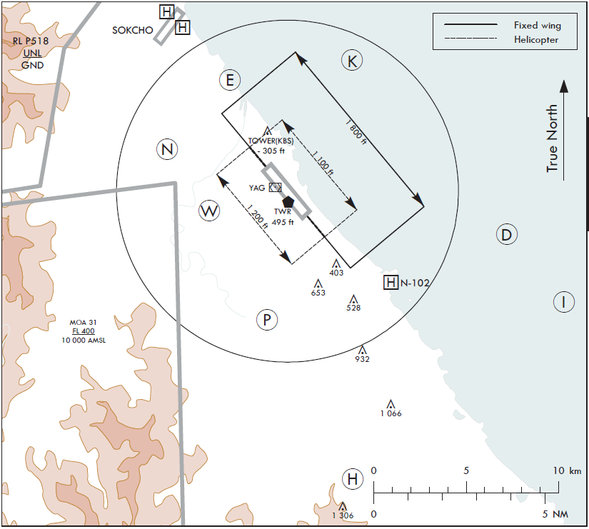
RKNY AD 2.10 AERODROME OBSTACLES
| In Area 2 |
|||||
| OBST ID/ Designation |
OBST type |
OBST position |
ELEV/HGT |
Markings/ Type, colour |
Remarks |
| a |
b |
c |
d |
e |
f |
| RKNY001 |
Mt.Samhuungjae-bong |
375425.5N 1284154.8E |
1 306 ft/ |
NIL |
15/APCH 33/TKOF |
| RKNY002 |
Mt.Ingu-ri |
375723.4N 1284347.1E |
1 066 ft/ |
NIL |
|
| RKNY003 |
Mt.Jeongyo-ri |
380029.1N 1284230.2E |
528 ft/ |
NIL |
33/APCH 15/TKOF |
| RKNY004 |
Mt.Chagol |
375859.9N 1284246.9E |
932 ft/ |
NIL |
|
| RKNY005 |
Mt.Cheonchi |
380058.0N 1284112.2E |
653 ft/ |
NIL |
|
| RKNY006 |
Mt.Jung gwanjeong-ri |
380132.8N 1284153.4E |
403 ft/ |
NIL |
|
| RKNY007 |
TOWER (KBS) |
380528.8N 1283927.7E |
305 ft/ |
NIL |
In circling area |
| In Area 3 |
|||||
| a |
b |
c |
d |
e |
f |
| NIL |
|||||
RKNY AD 2.11 METEOROLOGICAL INFORMATION PROVIDED
| 1 |
Associated MET Office |
Yangyang Airport Weather Station (Tel : +82-33-671-0365, Telefax : +82-33-673-0366) |
| 2 |
Hours of service MET Office outside hours |
Aerodrome Operating hours |
| 3 |
Office responsible for TAF preparation Periods of validity |
Aviation Meteorological Office 30 hours at 0000, 0600, 1200, 1800 UTC |
| 4 |
Trend forecast Interval of issuance |
Trend Type forecast 1 hour (METAR) and when SPECI reported |
| 5 |
Briefing/consultation provided |
Avaliable at the station during aerodrome operating hours |
| 6 |
Flight documentation Language(s) used |
Aerodrome forecasts (TAF code form), SIGWX charts, WINTEM charts, SIGMET information in English |
| 7 |
Charts and other information available for briefing or consultation |
Analysis charts (surface and upper air), Prognostic charts, Graphic displays and other model out puts |
| 8 |
Supplementary equipment available for providing information |
Satellite and Weather radar imageries Low Level Wind shear Alert System |
| 9 |
ATS units provided with information |
FIC and TWR |
| 10 |
Additional information(limitation of service, etc.) |
Automated METAR is provided during non-operational hours of the aerodrome. All observation data, model outputs and forecasts produced by KMA and WAFS are available at the office through Internet link |
RKNY AD 2.12 RUNWAY PHYSICAL CHARACTERISTICS
| Designations Runway NR |
TRUE BRG |
Dimension of RWY(M) |
Strength(PCN) and surface of RWY and SWY |
THR coordinates RWY end coordinates THR geoid undulation |
THR elevation and highest elevation of TDZ of precision APP RWY |
|||
|---|---|---|---|---|---|---|---|---|
| 1 |
2 |
3 |
4 |
5 |
6 |
|||
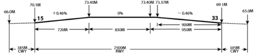
| 15 |
141.16° |
2500 × 45 |
53/F/A/X/T Asphalt |
380412.18N 1283936.66E ─ GUND 26.4 m |
THR: 70.1 m / 230 ft TDZ: 73.4 m / 240.8 ft |
|||
| 33 |
321.16° |
2 500 x 45 |
53/F/A/X/T Asphalt |
380309.21N 1284041.25E ─ GUND 26.4 m |
THR: 69.1 m / 22 6. 7 ft TDZ: 73.4 m / 240.8 ft |
|||
| 7. Slope of RWY-SWY |
||||||||
|
||||||||
| SWY dimensions(M) |
CWY dimensions(M) |
Strip dimensions(M) |
RESA dimensions (m) |
Location & description of arresting system |
OFZ |
|
|---|---|---|---|---|---|---|
| 8 |
9 |
10 |
11 | 12 | 13 |
|
| NIL |
345 × 300 |
2 620 × 300 |
240 x 150 |
NIL |
Comforms to the standards specified in ANNEX 14 chapter 4 |
|
| NIL |
345 × 300 |
2 620 × 300 |
240 x 150 |
NIL |
||
| 14. Remarks: RWY grooved 1900 + 45 m EXC 300 m inward each RWY THR. |
||||||
RKNY AD 2.13 DECLARED DISTANCES
| RWY Designator |
TORA (M) |
TODA (M) |
ASDA (M) |
LDA (M) |
Remarks |
|---|---|---|---|---|---|
| 1 |
2 |
3 |
4 |
5 |
6 |
| 15 |
2 500 |
2 845 |
2 500 |
2 500 |
NIL |
| 15 |
1 370 |
1 715 |
1 370 |
1 370 |
Take-off from intersection with TWY A |
| 15 |
1 740 |
2 085 |
1 740 |
1 740 |
Take-off from intersection with TWY B |
| 33 |
2 500 |
2 845 |
2 500 |
2 500 |
NIL |
| 33 |
1 130 |
1 475 |
1 130 |
1 130 |
Take-off from intersection with TWY A |
| 33 |
760 |
1 105 |
760 |
760 |
Take-off from intersection with TWY B |
RKNY AD 2.14 APPROACH AND RUNWAY LIGHTING
| RWY Designator |
APCH LGT type LEN INTST |
THR LGT Color WBAR |
VASIS (MEHT) PAPI |
TDZ LGT LEN |
RWY Center Line LGT LEN, Spacing Color, INTST |
RWY edge LGT LEN, Spacing Color, INTST |
RWY End LGT Color WBAR |
SWY LGT LEN(M) Color |
|---|---|---|---|---|---|---|---|---|
| 1 |
2 |
3 |
4 |
5 |
6 |
7 |
8 |
9 |
| 15 |
SALS (SSALF) 420 M LIH |
Green - |
PAPI Both/3° (57.7 ft) |
NIL |
2500 m 30 m White/Red LIH |
2500 m 60 m White/Yellow LIH |
Red - |
NIL |
| 33 |
ALSF-I 900 M LIH |
Green - |
PAPI Left/3° (57.7 ft) |
900 m |
2500 m 30 m White/Red LIH |
2500 m 60 m White/Yellow LIH |
Red - |
NIL |
| 10. Remarks
|
||||||||
RKNY AD 2.15 OTHER LIGHTING, SECONDARY POWER SUPPLY
| 1 |
ABN/IBN location, characteristics and hours of operation |
ABN : At tower building, FLG W/G EV 2~3 SEC/IBN : NIL H24 |
| 2 |
LDI location and LGT Anemometer location and LGT |
LDI: NIL Anemometer : Anemometer : 230 m from RWY 15 THR30 m from RWYAnemometer : Anemometer : 230 m from RWY 15 THR30 m from RWY 15 THR15Anemometer : Anemometer : 230 m from RWY 15 THR30 m from RWYAnemometer : Anemometer : 230 m from RWY 15 THR30 m from RWY 15 THR15 THR Anemometer : 350 m from RWY 33 THR and LGT NIL |
| 3 |
TWY edge and center line lighting |
Edge : All TWY Center line : NIL |
| 4 |
Secondary power supply/swithch-over time |
Secondary power supply to all lighting at AD Switch-over time : 1 or 15 SEC according to a kind of lights (Complied with ICAO requirements) |
| 5 |
Remarks |
NIL |
RKNY AD 2.16 HELICOPTER LANDING AREA
| 1 |
Coordinates TLOF or THR of FATO Geoid undulation |
NIL |
| 2 |
TLOF and/or FATO elevation M/FT |
NIL |
| 3 |
TLOF and FATO area dimensions, surface, strength, marking |
NIL |
| 4 |
True BRG of FATO |
NIL |
| 5 |
Declared distance available |
NIL |
| 6 |
APP and FATO lightng |
NIL |
| 7 |
Remarks |
NIL |
RKNY AD 2.17 ATS AIRSPACE
| 1 |
Designation and lateral limit |
YANGYANG CTR A circle, radius 5 NM centered at 380341N 1284009E (ARP) |
| 2 |
Vertical limits |
SFC to 3000 ft AGL |
| 3 |
Airspace classification |
D |
| 4 |
ATS unit call sign Languages |
YANGYANG Tower English / Korean |
| 5 |
Transition altitude |
14000 ft AMSL |
| 6 |
Operational hours |
23:00-09:00 UTC* * Outside these hours, services are available on prior request (passenger flights only) |
| 7 |
Remarks |
NIL |
RKNY AD 2.18 ATS COMMUNICATION FACILITIES
| Service designation |
Call sign |
Frequency(Mhz) |
Hours of operation |
Remarks |
|---|---|---|---|---|
| 1 |
2 |
3 |
4 |
5 |
| TWR |
Yangyang Tower |
118.85 MHz, 240.4 MHz, 124.375 MHz |
2300-0900 UTC* |
*Outside these hours services are available on request (passenger flights only) |
| GND,DLVRY |
Yangyang Ground |
124.3 MHz 240.4 MHz |
2300-0900 UTC* |
*Outside these hours services are available on request (passenger flights only) |
| ATIS |
Yangyang INTL airport |
128.8128.8725 MHz,5 MHz, 234.1 MHz |
H24 |
NIL |
| APP |
Gangneung Approach |
124.6 MHz, 304.0 MHz |
H24 |
NIL |
| DEP |
Gangneung Departure |
124.6 MHz, 258.4 MHz |
H24 |
NIL |
| EMERG |
121.5 MHz, 243.0 MHz |
H24 |
NIL |
|
| * Scheduled Maintenance Time: - TWR, GND, DLVRY, ATIS, EMERG : Every 4th TUE(1300 - 1800 UTC) of the month |
||||
RKNY AD 2.19 RADIO NAVIGATION AND LANDING AIDS
| Type of aid, CAT of ILS/MLS |
ID |
Frequency |
Hours of operation |
Position of transmitting antenna coordinates |
Elevation of DME transmitting antenna |
Remarks |
|---|---|---|---|---|---|---|
| 1 |
2 |
3 |
4 |
5 |
6 |
7 |
| VOR/DME |
YAG |
110.6 MHz (CH43) |
H24 |
380348.0N 1283941.3E (VOR) 380348.1N 1283941.8E (DME) |
120 m |
VOR/DME unusable RDL 231 clockwise RDL 310 not flight due to P518 & terrain RDL 311 clockwise RDL 360 beyond 7.5 NM not flight due to P518 RDL 001 clockwise RDL 070 beyond 10 NM not flight due to restricted area DME unusable RDL 200 clockwise RDL 230 beyond 17 NM below 7 500 ft AMSL Scheduled Maintenance Time: Every 1st TUE(1300~1800 UTC) of the month |
| LOC 33 |
IYAN |
109.3 MHz |
H24 |
380419.6N 1283929.0E |
RWY33 LOC unusable beyond 17 NM from LOC, due to MOA & beyond 10 degree s left side of the course , due to OBST Scheduled Maintenance Time: Every 2nd TUE(1300~1800 UTC) of the month |
|
| DME 33 |
IYAN |
991 MHz (CH 30X) |
H24 |
380313.8N 1284030.0E |
75 m |
Scheduled Maintenance Time: Every 3rd TUE(1300~1800 UTC) of the month |
| GP 33 |
332.0 MHz |
H24 |
380313.9N 1284030.1E |
RWY 33 Glide path unusable : beyond 5 degree s left side of the course, due to OBST Scheduled Maintenance Time: Every 3rd TUE(1300~1800 UTC) of the month |
||
| VORTAC |
KAE |
115.6 MHz (CH103) |
H24 |
374202.7N 1284513.5E |
- |
Unusable and scheduled inspection time : See ENR 4.1 for the details |
RKNY AD 2.20 LOCAL AERODROME REGULATIONS
1 Airport regulations
| Taxiway | A | Up to code letter " E " available |
| Taxilane | N1, N2 | Up to code letter " A " available |
Aircraft Stand "49" is a place for aircraft that do not operate long-term.
RKNY AD 2.21 NOISE ABATEMENT PROCEDURES
1 Aircraft Operating Procedures(except helicopter)
All departing aircraft should apply ICAO PANS-OPS(Doc 8168), Volume I, Noise Abatement Take-off Climb Procedure as follows :
Noise Abatement Department Procedure ONE (NADP ONE)
Thrust reduction at 1 000 ft or 1 500 ft above aerodrome elevation recommended
RKNY AD 2.22 FLIGHT PROCEDURES
1 IFR PROCEDURE
The following procedures are established for all turbo jet departures from Yangyang International Airport :
-
Aircraft shall contact Clearance Delivery and provide the following information 5 minutes prior to startup or push-back.
-
Aircraft Identification
-
Type of aircraft
-
Destination
-
Proposed flight level or altitude
-
Gate or stand number
-
-
If aircraft fails to push-back or taxi within 15 minutes after receipt of ATC clearance, pilot should notify ATC except when :
-
Start-up or push-back is delayed due to traffic on the ground or
-
Aircraft departure is restricted by the release time or the same altitude /route separation
-
Unless otherwise authorized by ATC, no person may operate an aircraft below 10 000 FT AMSL at an IAS of more than 250 KT.
As instructed by ATC
Visual Approach may be initiated by ATC(GANGNEUNG approach control) or approved upon pilot request on traffic permitting basis when :
-
Ceiling : at or above 500 FT plus MVA and
-
Visibility : not less than 5 KM (3 SM)
-
Circuit : east pattern only
2 VFR
-
VFR Weather minima VFR flight will be permitted under the conditions as below
-
Ground Visibility : Not less than 5 KM(3 SM)
-
Ceiling : at or above 60 0 M( 2 00 0 FT)
-
-
VFR Reporting points(Refer to VFR Traffic Points - RKNY)
-
VFR Traffic Circuit(Refer to VFR Traffic Circuit - RKNY)
-
VFR Pattern Altitude
-
West Pattern
- Helicopter only : 1 200 FT
-
East Pattern
- Helicopter : 1 100 FT
- Fixed wing : 1 800 FT
-
-
VFR Flight Procedures for helicopters
-
All VFR flight operation within Yangyang Control Zone shall maintain two way radio communication with Yangyang Tower.
-
Pilots shall use caution during flight especially in the west of airport due to high obstacles like mountains, electric towers, and so on.
-
-
Followings are Flight procedures for fixed wing aircraft practicing in the VFR Traffic circuit
-
Runway 15 in use
- After take-off or Touch and go, fly runway heading
- Turn left for crosswind leg after passing a point abeam of Ondiet camp(Pension)
- Turn left for downwind leg after passing a point abeam of Susanhang Lighthouse
- Before Naksan Bridge, turn left to Yangyangkyo (bridge) for base leg
-
Runway 33 in use
- After take-off or Touch and go, fly runway heading
- Turn right for crosswind leg after passing a point abeam of Yangyangkyo(bridge)
- Turn right for downwind leg after passing a point abeam of Susanhang Lighthouse
- Before Simmi apartment, turn right to Sankwabada (Pension) for base leg
-
-
Inbound and outbound flight procedures for fixed wing aircraft, refer to RKNY AD 2-12-1.
-
Special VFR flight for taking off or landing may only be permitted except helicopters, when
-
The ground visibility is not less than 1 500 M.
-
If ground visibility is not reported at airport, flight visibility is not less than 1 500 M (transition).
-
-
For Special VFR operations, the pilot shall :
-
fly only within control zone as cleared by ATC.
-
remain clear of clouds.
-
maintain at least 1 500 M of flight visibility.
-
maintain visual reference with surface or water.
-
Special VFR may be permitted only time between sunrise and sunset unless the pilot is instrument rated and the aircraft is equipped with IFR flight instruments in accordance with the requirement specified in Aviation Act(Except helicopters).
-
3 Radio communication failure procedure
-
General
-
No person may take off unless two-way radio communications can be maintained with the Air Traffic Control.
-
On recognition of communication failure during flight, squawk 7600 and if necessary to ensure safe altitude, climb to Minimum Safe Altitude or above to maintain obstacles clearance. Then comply with following procedures.
-
-
VFR condition
If the radio failure occurs in VFR conditions, or if VFR conditions are encountered after the radio failure, each pilot shall continue the flight under VFR and land as soon as practicable in accordance with runway in use.
-
IFR condition
If the radio failure occurs in IFR conditions, or if paragraph 2 of this section cannot be complied with, each pilot shall continue the flight according to the following :
-
DEPARTURE
-
Under Pilot Navigation
Runway 15 in use
1) YAG(Yangyang) TWO SIERRA
-
Maintain 8 000 FT until KAE then climb and proceed by the route, altitude/flight level assigned in the last ATC clearance received.
2) YAG(Yangyang) TWO TANGO
-
Maintain 10 000 FT until KAE then climb and proceed by the route, altitude/flight level assigned in the last ATC clearance received.
Runway 33 in use
1) YAG(Yangyang) TWO ALPHA(CAT A&B)
-
Maintain 10 000 FT until KAE then climb and proceed by the route, altitude/flight level assigned in the last ATC clearance received.
2) YAG(Yangyang) TWO ALPHA(CAT C&D)
-
Maintain 10 000 FT until KAE then climb and proceed by the route, altitude/flight level assigned in the last ATC clearance received.
-
-
Under Radar Vectoring
- Proceed by the direct route from the point of radio failure to the fix, route, or airway specified in the vector clearance;
- In the absence of an assigned route, proceed by the route that ATC has advised may be expected in a further clearance; or
- In the absence of an assigned route or a route that ATC has advised may be expected in a further clearance, by the route filed in the flight plan; and
- maintain minimum en route altitude(MEA) or the altitude/flight level cleared in the last ATC clearance received, whichever is higher, for 20 minutes; then
- continue the flight with altitude/flight level filed in the flight plan.
-
-
ARRIVAL
Runway 33 in use
1) Proceed to DOWON IAF and commence descent and approach as close as possible to the expect further clearance time(EFC) issued by ATC or estimated time of arrival(ETA) filed in the flight plan; and
2) Land, if possible, within 30 minutes after ETA or the last acknowledged EFC or ETA, whichever is later;
3) Circling not authorized west of runway 15-33.
-
-
VFR flight experiencing radio communication failure shall
-
Helicopter
- Squawk 7600, and
- When able to see light gun signal of control tower, follow that instruction.
- If unable to see light gun signal of control tower, hold over downwind until ETA or for 10 minutes, whichever is longer, then
- Make landing on runway 15/33 in use as appropriate.
- Pilot shall use caution traffic landing and takeoff from/to runway.
-
Conventional flight
- Squawk 7600, and
- When able to see light gun signal of control tower, follow that instruction.
- If unable to see light gun signal of control tower, hold over down-wind until ETA or for 10 minutes, whichever is longer, then
- Make landing on runway 15/33 in use as appropriate.
- Pilot shall use caution traffic landing and takeoff from/to runway.
-
4 Take-off Weather Minima
| Facilities |
RWY |
3 RVR REQ |
REDL & RCLL |
REDL & RCL*** |
REDL or RCL*** REDL & RCL*** |
NIL (Day Only) |
||
| TGS*, HIRL & RCLL |
HIRL & RCLL |
REDL & RCLL |
(For Night Operations***) |
REDL & RCL*** (For Night Operations***) |
||||
| RVR / VIS** |
||||||||
| Multi- Engine ACFT |
15 |
- |
- |
- |
- |
- |
400 m / 1 200 ft |
500 m / 1 600 ft |
| 33 |
- |
- |
- |
- |
- |
400 m / 1 200 ft |
500 m / 1 600 ft |
|
Note : SIDs are designed in accordance with STANDARDS for FLIGHT PROCEDURE DESIGN.
* With certified TGS(Take-off Guidance System).
** The TDZ RVR/VIS may be assessed by the pilot.
*** For Night Operations at least REDL or RCLL and RENL are available.
VFR Traffic Circuits - Yangyang INTL Airport
.png)
Note
1. The areas specified at the ENR 1.5 holding, approach and departures 2.3 PANS-OPS visual manoeuvering areas used for obstacles.
2. East traffic pattern altitudes for runways are for CAT H-D.
3. Fixed wing is only available east traffic pattern.
| VFR Reporting Point |
|||
| Reporting Point |
Geographical Name |
Position |
Coordinates(WGS-84) |
| N |
The 95 M hill southwest of Araemal 아랫말 남동쪽 95고지 |
3.7 NM NW of airport R 299 YAG/D3.4 |
380500N 1283544E |
| W |
The 167M hill north of Sambarijae 삼바리재 북쪽 167고지 |
2.3 NM W of airport R 261 YAG/D2.0 |
380311N 1283715E |
| P |
The 223M hill east of Dangsandong 당산동 동쪽 223고지 |
3.8 NM S of airport R 193 YAG/D3.9 |
375956N 1283917E |
| E |
Naksan beach 낙산해수욕장 |
3.6 NM NW of airport R 347 YAG/D3.4 |
380659N 1283807E |
| K |
4.6 NM East of Naksan Temple 낙산사 동쪽 4.6마일 해상 |
5 NM NE of airport R 045 YAG/D5.1 |
380755N 1284335E |
| D |
4 NM East of Gisamunri 기사문리 동쪽 4마일 해상 |
6.4 NM SE of airport R 111 YAG/D6.8 |
380216N 1284807E |
| H |
Hawolcheonri 하월천리 |
8.6 NM S of airport R 174 YAG/D8.8 |
375513N 1284218E |
| I |
4.4 NM East of Kwangjinri 광진리 동쪽 4.4마일 해상 |
8.6 NM SE of airport R 121 YAG/D9.0 |
380015N 1285010E |
| VFR In/Outbound Flow Chart - Yangyang INTL Airport 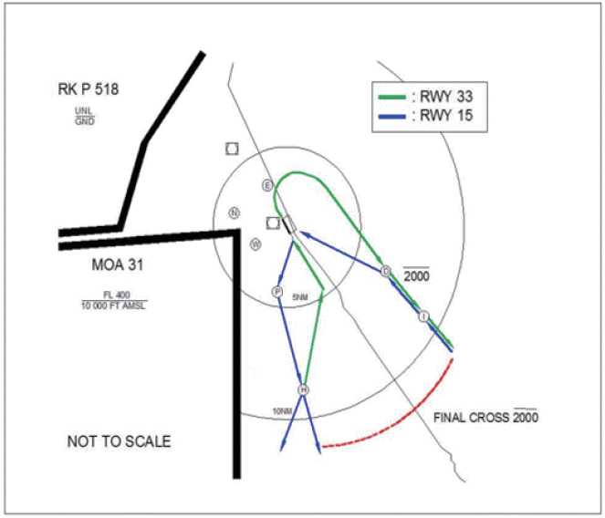
|
| RWY 15 VFR ARRIVAL Contact Yangyang TWR when passing "I"point, then proceed to downwind leg via "D" point. RWY 15 VFR DEPARTURE Turn right when passing threshold and proceed to "P" and "H" point. (recommended altitude 2 600 ft). Maintain at or below 2 000 ft when passing 12 DME from YAG, then climb VFR. RWY 33 VFR ARRIVAL Contact Yangyang TWR when passing "H" point(recommended altitude 2 600 ft), then proceed to 4 miles on final. RWY 33 VFR DEPARTURE Turn right when passing abeam Yangyang bridge and proceed to "D" and "I" point. Maintain at or below 2 000 ft until 12 DME from YAG, then climb VFR. Note Maintain at or below 2 000 ft and use caution IFR inbound traffic when flying across the final course 12 DME away from YAG. |
RKNY AD 2.23 ADDITIONAL INFORMATION
-
Bird concentrations in the vicinity of the airport
Sometimes birds such as a duck, a wild goose and a crow, fly the shore(from RWY 15 to RWY 33) from a river which is located in the NE of airport. Heights varies from 0 - 2 000 FT (0 - 600 M) as far as practicable aerodrome control will inform pilots of this bird activity and the estimated heights AGL during the above periods. Pilots of aircraft are advised where the design limitations of aircraft installations permit to operate landing light in flight take-off, approach-to-land and climb and descent procedures disposal activities to bird around the RWY area include AV-alarm and Birdguard pro. Modifications of the environment are under way to reduce if they cannot eliminate the hazard. They comprise better methods of garage disposal and elimination of hedge and ground cover and cessation of farming activity.
