RKJB — Muan
RKJB AD 2.1 AERODROME LOCATION INDICATOR AND NAME
RKJB - MUAN / Muan International
RKJB AD 2.2 AERODROME GEOGRAPHICAL AND ADMINISTRATIVE DATA
| 1 |
ARP coordinates and site at AD |
345929N 1262258E 180° / 1 402 M from THR 19 |
| 2 |
Direction and distance from city |
254°, 46 KM from GwangJu City Hall 004°, 20 KM from Mokpo City Hall |
| 3 |
Elevation/Reference temperature |
16 m / 31.5°C |
| 4 |
Geoid undulation at the aerodrome elevation |
24 M |
| 5 |
MAG VAR/Annual change |
|
| 6 |
Aerodrome Operator, Address,Telephone, Telefax, AFS |
Muan Airport Branch (Busan Regional Office of Avi ation) Gonghang-ro, Mangun-myeon, Muan-gun, Jeollanam-do, 5 8533 Republic of Korea
Tel : +82-61-453-0737
Telefax : +82-61-453-0767
AFS : RKJBZPZX |
| 7 |
Type of traffic permitted(IFR/VFR) |
IFR/VFR |
| 8 |
Remarks |
NIL |
RKJB AD 2.3 OPERATIONAL HOURS
| 1 |
Aerodrome Operator |
H24 |
| 2 |
Customs and Immigration |
HO |
| 3 |
Health and Sanitation |
HO |
| 4 |
AIS Briefing Office |
H24 |
| 5 |
ATS Reporting Office |
H24 |
| 6 |
MET Briefing Office |
H24 |
| 7 |
ATS |
H24 |
| 8 |
Fuelling |
HO |
| 9 |
Handling |
HO |
| 10 |
Security |
HO |
| 11 |
De-icing |
HO |
| 12 |
Remarks |
- Take-off and landing is restricted from 1200 UTC to 2300 UTC due to noise abatement(except passenger flights) - CAT D AND E ACFT OPR is available under the pre-coordination due to ground handling service facilities Tel : +82-61-455-2333 |
RKJB AD 2.4 HANDLING SERVICES AND FACILITIES
| 1 |
Cargo handling facilities |
Baggage Handling service and trucks |
| 2 |
Fuel/oil types |
Fuel : Aviation Turbine Fuel(Jet A-1) |
| 3 |
Fuelling facilities/capacity |
Refueling available by trucks. Jet A-1 : Elevated storage tank 3units.(Total 1 470 000 Liters, 3 fuel tanks with 390 000 Liters) |
| 4 |
De-icing facilities |
Available. See AD chart for location. |
| 5 |
Hangar space for visiting aircraft |
NIL |
| 6 |
Repair facilities for visiting aircraft |
NIL |
| 7 |
Remarks |
NIL |
RKJB AD 2.5 PASSENGER FACILITIES
| 1 |
Hotels |
Near the AD and in the city(Mokpo & Gwangju) |
| 2 |
Restaurants |
At AD and in the city(Mokpo & Gwangju) |
| 3 |
Transportation |
Buses, Taxis and rental cars available at AD |
| 4 |
Medical Facilities |
|
| 5 |
Bank and Post Office |
Bank available at AD |
| 6 |
Tourist Office |
Available at AD |
| 7 |
Remarks |
https://www.airport.co.kr/muan/ |
RKJB AD 2.6 RESCUE AND FIRE FIGHTING SERVICES
| 1 |
AD Category for fire fighting |
CAT 9 |
| 2 |
Rescue equipment |
|
| 3 |
Capability for removal of disabled aircraft |
Specialized aircraft recovery equipment available for up to and including B747-400 size aircraft. 100 ton hydraulic recovery jack, 300 ton crane and other accessory equipment can be provided by airlines and agencies. Korea Airports Corporation is the co-ordinator for the removal of disabled aircraft and can be reached at Tel : +82-61-455-2331(Airport Duty Manager) |
| 4 |
Remarks |
*AFFF: Aqueous Film Forming Foam |
RKJB AD 2.7 SEASONAL AVAILABILITY-CLEARING
| 1 |
Type of clearing equipment |
|
| 2 |
Clearance priorities |
|
| 3 |
Remarks |
Snow clearance information promulgated by SNOWTAM. |
RKJB AD 2.8 APRONS, TAXIWAYS AND CHECK LOCATIONS / POSITION DATA
| 1 |
Designation, Surface and strength of aprons |
Stand 1 ~ 4, 31 ~ 74- Surface : Concrete- Strength : PCN 81/R/C/W/T Stand 5 ~ 6- Surface : Concrete- Strength : PCN 85/R/C/W/T |
|||||||||||||||||||
| 2 |
Designation, Taxiway width, surface and strength |
|
|||||||||||||||||||
| 3 |
Location and elevation of altimeter checkpoint |
Location : At Apron Elevation : 12 M |
|||||||||||||||||||
| 4 |
VOR check points |
VOR : See AD chart |
|||||||||||||||||||
| 5 |
INS check points |
INS : See Aircraft Parking & Docking Chart |
|||||||||||||||||||
| 6 |
Remarks |
NIL |
RKJB AD 2.9 SURFACE MOVEMENT GUIDANCE & CONTROL SYSTEM AND MARKINGS
| 1 |
Use of aircraft stand ID signs, TWY guide lines and visual docking/ parking guidance system at aircraft stands |
|
| 2 |
RWY and TWY markings and LGTs |
|
| 3 |
Stop bars |
NIL |
| 4 |
Remarks |
A road-holding position sign shall be provided at all road entrances to a runway. |
RKJB AD 2.10 AERODROME OBSTACLES
| In Area 2 |
|||||
| OBST ID/ Designation |
OBST type |
OBST position |
ELEV/HGT |
Markings/ Type, colour |
Remarks |
| a |
b |
c |
d |
e |
f |
| RKJBOB001 |
Hill |
345636.9N 1262343.6E |
602 ft/ |
NIL |
01 /APCH 19 /TKOF |
| RKJBOB002 |
Hill |
344842.1N 1262427.2E |
514 ft/ |
NIL |
|
| RKJBOB003 |
Hill |
345125.8N 1262455.0E |
678 ft/ |
NIL |
|
| RKJBOB004 |
Hill |
345656.8N 1262329.6E |
266 ft/ |
NIL |
|
| RKJBOB005 |
Hill |
344218.7N 1262025.7E |
948 ft/ |
NIL |
|
| RKJBOB006 |
Hill |
344723.7N 1262221.5E |
754 ft/ |
NIL |
|
| RKJBOB007 |
Hill |
350037.8N 1262300.9E |
81 ft/ |
NIL |
19 /APCH 01 /TKOF |
| RKJBOB008 |
Hill |
351022.3N 1262607.1E |
1 331 ft/ |
NIL |
|
| RKJBOB009 |
Hill |
350258.2N 1262129.7E |
342 ft/ |
NIL |
|
| RKJBOB010 |
Hill |
350313.4N 1262236.5E |
276 ft/ |
NIL |
|
| RKJBOB011 |
Hill |
351126.4N 1263354.0E |
1 701 ft/ |
NIL |
|
| In Area 3 |
|||||
| OBST ID/ Designation |
OBST type |
OBST position |
ELEV/HGT |
Markings/ Type, colour |
Remarks |
| a |
b |
c |
d |
e |
f |
| NIL |
|||||
RKJB AD 2.11 METEOROLOGICAL INFORMATION PROVIDED
| 1 |
Associated MET Office |
Muan Airport Weather Office TEL : +82-61-453-4365 FAX : +82-61-453-5365 |
| 2 |
Hours of service MET Office outside hours |
Aerodrome Operating hours |
| 3 |
Office responsible for TAF preparation periods of validity |
Muan Airport Weather Office 30 hours at 0000, 0600, 1200, 1800 UTC |
| 4 |
Trend forecast Interval of issuance |
Trend Type forecast 1 hour (METAR) and when SPECI reported |
| 5 |
Briefing/consultation provided |
Available at the Office for 24 hours, if required |
| 6 |
Flight documentation Language(s) used |
Aerodrome forecasts(TAF code form), SIGWX charts, WINTEM charts, SIGMET information in English |
| 7 |
Charts and other information available for briefing or consultation |
Analysis charts(surface and upper air), Prognostic charts, Graphic displays and other model outputs |
| 8 |
Supplementary equipment available for providing information |
Satellite and Weather radar imageries |
| 9 |
ATS units provided with information |
FIC and TWR |
| 10 |
Additional informaton |
Automated METAR is provided during non-operational hours of the aerodrome. All observation data, model outputs and forecasts produced by KMA and WAFS are available at the office through internet link. |
RKJB AD 2.12 RUNWAY PHYSICAL CHARACTERISTICS
| Designations Runway NR |
Thru BRG TRUE BRG |
Dimension of RWY(M) |
Strength(PCN) and surface of RWY |
THR coordinates RWY end coordinates THR geoid undulation |
THR elevation and highest elevation of TDZ of precision APP RWY |
|---|---|---|---|---|---|
| 1 |
2 |
3 |
4 |
5 |
6 |
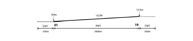
| 01 |
359.67° |
2 800 × 45 |
78/F/C/X/T Asphalt |
345843.64N 1262258.45E GUND :23.7 m |
THR : 9.9 m/32.5 ft TDZ : 1 1 .7 m/3 8.4 ft |
| 19 |
179.67° |
2 800 × 45 |
78/F/C/X/T Asphalt |
350014.49N 1262257.82E GUND : 23.6 m |
THR : 15.5 m/50.9 ft TDZ : 1 5.5 m/50.9 ft |
| 7. Slope of RWY-SWY |
|||||
|
|||||
| SWY dimensions(M) |
CWY dimensions(M) |
Strip dimensions(M) |
RESA dimensions (m) |
Location & description of arresting system |
OFZ |
Remarks |
|
|---|---|---|---|---|---|---|---|
| 8 |
9 |
10 |
11 |
12 |
1 3 |
1 4 |
|
| NIL |
200 × 150 |
2 920 × 300 |
202 × 150 |
NIL |
NIL |
The surface of RWY is grooved. |
|
| NIL |
200 × 150 |
2 920 × 300 |
199 × 150 |
NIL |
NIL |
||
RKJB AD 2.13 DECLARED DISTANCES
| RWY Designator |
TORA (M) |
TODA (M) |
ASDA (M) |
LDA (M) |
remarks |
|---|---|---|---|---|---|
| 1 |
2 |
3 |
4 |
5 |
6 |
| 01 |
2 800 |
3 000 |
2 800 |
2 800 |
NIL |
| 19 |
2 800 |
3 000 |
2 800 |
2 800 |
NIL |
| 19 |
2 057 |
2 257 |
2 057 |
2 057 |
Take-off from intersection with TWY E2 |
RKJB AD 2.14 APPROACH AND RUNWAY LIGHTING
| RWY |
APCH LGT type LEN INTST |
THR LGT Color WBAR |
VASIS (MEHT) PAPI |
TDZ LGT LEN |
RWY Center line LGT LEN Spacing Color INTST |
RWY edge LGT LEN Spacing Color INTST |
RWY End LGT Color WBAR |
SWY LGT LEN(M) color |
Remarks |
|---|---|---|---|---|---|---|---|---|---|
| 1 |
2 |
3 |
4 |
5 |
6 |
7 |
8 |
9 |
10 |
| 01 |
ALSF-I 900 M LIH |
Green Green |
PAPI Left/3° (54.2 FT) |
900 M |
2 800 M 30 M White LIH |
2 800 M 60 M White LIH |
Red - |
NIL |
NIL |
| 19 |
ALSF-I 900 M LIH |
Green Green |
PAPI Left/3° (53.3 FT) |
900 M |
2 800 M 30 M White LIH |
2 800 M 60 M White LIH |
Red - |
NIL |
NIL |
RKJB AD 2.15 OTHER LIGHTING, SECONDARY POWER SUPPLY
| 1 |
ABN/IBN location, characteristics and hours of operation |
ABN: At tower building, FLG W/G EV 2~3 SEC/IBN: NIL H24 |
| 2 |
LDI location and lighting Anemometer location and lighting |
LDI: NIL Anemometer: 392 M from THR RWY 01/19, lighted |
| 3 |
TWY edge and center line lighting |
Edge : All TWY Center line : NIL |
| 4 |
Secondary power supply/swithch-over time |
Secondary power supply to all lighting at AD. Switch-over time : 1 or 15 SEC according to a kind of lights |
| 5 |
Remarks |
NIL |
RKJB AD 2.16 HELICOPTER LANDING AREA
| 1 |
Coordinates TLOF or THR of FATO |
NIL |
| 2 |
TLOF and/or FATO elevation |
NIL |
| 3 |
TLOF and FATO area dimensions, surface, strength, marking |
NIL |
| 4 |
True and MAG BRG of FATO |
NIL |
| 5 |
Declared distance available |
NIL |
| 6 |
APP and FATO lightng |
NIL |
| 7 |
Remarks |
NIL |
RKJB AD 2.17 ATS AIRSPACE
| 1 |
Designation and lateral limit |
MUAN CTR; A circle, radius 5NM centered at ARP including areas which are extended northbound from 350409N 1262045E - 350601N 1262044E - 350602N 1262507E - 350410N 1262508E and southbound from 345449N 1262511E - 345255N 1262512E - 345254N 1262050E - 345448N 1262049E. |
| 2 |
Vertical limits |
SFC to 3 000 FT AGL |
| 3 |
Airspace classification |
D |
| 4 |
ATS unit call sign Languages |
MUAN Tower English/Korean |
| 5 |
Transition altitude |
14 000 FT AMSL |
| 6 |
Operational hours |
|
| 7 |
Remarks |
NIL |
RKJB AD 2.18 ATS COMMUNICATION FACILITIES
| Service designation |
Call sign |
Frequency(MHz) |
Hours of operation |
Remarks |
|---|---|---|---|---|
| 1 |
2 |
3 |
4 |
5 |
| APP |
Gwangju Approach |
120.475 130.0 228.9 265.5 319.2 |
H24 |
NIL |
| DEP |
Gwangju Departure |
124.0 124.7 347.2 |
H24 |
NIL |
| TWR |
Muan Tower |
118.25 118.85 321.025 |
H24 |
NIL |
| GND |
Muan Ground |
121.7 317.45 |
H24 |
NIL |
| ATIS |
Muan Information |
127.425 335.425 |
H24 |
NIL |
| EMERG |
121.5 243.0 |
H24 |
NIL |
|
| Scheduled Inspection Time : - APP(120.475 MHz, 265.5 MHz), DEP(124.0 MHz, 124.7 MHz), TWR, GND, ATIS and EMERG : Every 1st THU (1500-2000UTC) of the month. |
||||
RKJB AD 2.19 RADIO NAVIGATION AND LANDING AIDS
| Type of aid, CAT of ILS/MLS |
ID |
Frequency |
Hours of operation |
Position of transmitting antenna coordinates |
Elevation of DME transmitting antenna |
Remarks |
|---|---|---|---|---|---|---|
| 1 |
2 |
3 |
4 |
5 |
6 |
7 |
| VOR/DME |
MUN |
111.0 MHz (CH47) |
H24 |
345812.7N 1262300.0E |
30 M |
Schedule inspection time: Every 3rd THU 15:00~ 20:00(UTC) of the month |
| LOC 01 ILS CAT I |
IMUN |
111.9 MHz |
H24 |
350023.1 N 1262257.8 E |
Schedule inspection time: Every 1st THU 15:00~ 20:00(UTC) of the month. Caution on Radio Altimeter Operation During ILS auto-coupled or automatic landing for RWY 01 or 19, aircraft may experience radio altitude fluctuation momently when passing over localizer antena site. |
|
| GP 01 |
331.1 MHz |
H24 |
345853.3 N 1262254.0 E |
- 3° - ILS RDH 50 FT |
||
| DME 01 |
1017 MHz (CH 56X) |
H24 |
345853.2 N 1262253.8 E |
0 M |
||
| LOC 19 ILS CAT I |
IMAN |
108.9 MHz |
H24 |
345835.0 N 1262258.5 E |
Schedule inspection time: Every 3r d THU 15:00~ 20:00(UTC) of the month. Caution on Radio Altimeter Operation During ILS auto-coupled or automatic landing for RWY 01 or 19, aircraft may experience radio altitude fluctuation momently when passing over localizer antenna site. |
|
| GP 19 |
329.3 MHz | H24 |
350004.3 N 1262253.5 E |
- 3° - ILS RDH 50 FT |
||
| DME 19 |
987 MHz (CH 26X) |
H24 |
350004.3 N 1262253.3 E |
30 M |
||
| KWA |
114.4 MHz (CH 91X) |
H24 |
350734.2N 1264844.0E |
30 m |
Unusable and scheduled inspection time : See ENR 4.1 for the details |
|
| Scheduled Inspection Time : RADAR(ASR/SSR) : Every 3rd THU 15:00~20:00(UTC) of the month |
||||||
RKJB AD 2.20 LOCAL AERODROME REGULATIONS
1 Airport regulations
-
Aircraft requiring an engine check shall contact Muan GND(121.7 MHz, 317.45 MHz) and provide the following:
1) Call sign or registration number
2) Stand number
3) Type of request, engine start or performance check
-
Engine starts are permitted in the ramp areas. However, the power setting shall not exceed idle thrust unless cleared by ATC.
-
During the engine check, pilot shall monitor the frequency of Muan GND(121.7 MHz, 317.45 MHz).
Unless otherwise instructed, aircraft should use the following routes:
-
Departure
1) RWY01 in use : Apron - A2 - P - E3
2) RWY19 in use : Apron - A1 - P - E1
-
Arrival
1) RWY01 in use : E2 or E1 - P - A1 - Apron
2) RWY19 in use : E3 - P - A2 - Apron
- Arrival
Arrival aircraft shall contact radio frequency from MUAN TOWER(118.25 MHz) to MUAN GROUND(121.7 MHz) when vacating Runway.
- Departure
Departure aircraft shall contact radio frequency MUAN TOWER(118.25 MHz) at the following point unless otherwise instructed by ATC :
| Runway in use |
Radio frequency transfer point |
| RWY 01 |
Passing TWY A2 |
| RWY 19 |
After passing the intersection of TWY E2, A1 and P |
RKJB AD 2.21 NOISE ABATEMENT PROCEDURES
| To be developed |
RKJB AD 2.22 FLIGHT PROCEDURES
1 IFR
The following procedures are established for all turbo jet departures from Muan International Airport:
-
Aircraft shall contact Clearance Delivery and provide the following information 5 minutes prior to startup or push-back.
1) Aircraft Identification
2) Type of aircraft
3) Destination
4) Proposed flight level or altitude
5) Gate or stand number
6) ATIS code
-
If aircraft fails to push-back or taxi within 15 minutes after receipt of ATC clearance, pilot should notify ATC except when :
1) Start-up or push-back is delayed due to traffic on the ground, or
2) Aircraft departure is restricted by the release time or the same altitude/route separation
Unless otherwise authorized by ATC, no pilot may operate an aircraft below 10 000 FT AMSL at an IAS of more than 250 KT.
Fuel Dumping Area is established within Gwangju TMA AS follows.
-
Area : A circle, 3 NM radius centered at MUN R-275/D22.
-
Altitude : 6 000 FT AMSL.
Visual Approach may be initiated by ATC(Gwangju approach control) or approved upon pilot request on traffic permitting basis when :
-
Ceiling : at or above 500 FT plus MVA and
-
Visibility : not less than 5 KM
-
Circuit : West pattern only
2 VFR
-
VFR flight will be permitted under the condition as below :
1) Ground visibility : Not less than 5 KM
(If Ground visibility is not reported, Flight visibility : Not less than 5 KM)
2) Ceiling : At or above 450 M(1 500 FT)
-
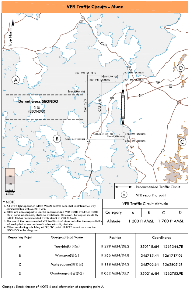
VFR Traffic Circuits : Refer to page RKJB AD 2-11
-
VFR Traffic Circuits Altitude
1) CAT A, B : 1 200 FT AMSL
2) CAT C, D : 1 700 FT AMSL
-
VFR Reporting Points : Refer to page RKJB AD 2-11
-
Special VFR Flight for taking off or landing may only be permitted except helicopters, when :
1) The ground visibility is not less than 1 500 M.
2) If ground visibility is not reported at airport, flight visibility is not less than 1 500 M.
-
For Special VFR, the pilot shall:
1) Fly only within Control Zone as cleared by ATC.
2) Remain clear of clouds.
3) Maintain at least 1 500 M of flight visibility.
4) Maintain visual reference with surface or water.
-
Special VFR may be permitted only between sunrise and sunset unless the pilot has a instrument rating and the aircraft is equipped with the instruments for IFR flight in accordance with requirement specified in an Aviation Act, Republic of Korea.(Except helicopters)
3 Radio communication failure procedure
-
General
-
No person may take off unless two-way radio communications can be maintained with the Air Traffic Control.
-
On recognition of communication failure during flight, squawk 7600 and if necessary to ensure safe altitude, climb to Minimum Sector Altitude or above to maintain obstacle clearance. Then comply with following procedure.
-
-
VFR condition
If the failure occurs in VFR conditions, or if VFR conditions are encountered after the failure, each pilot shall continue the flight under VFR and land as soon as practicable.
-
IFR condition
If the failure occurs in IFR conditions, or if paragraph 2 of this section cannot be complied with, each pilot shall continue the flight according to the following:
-
DEPARTURE
-
Under Pilot Navigation
Runway 01 in use
- RNAV MAKSA 1N, RNAV DOTOL 1N, KWA 2N :
-
Proceed by the route, altitude/flight level assigned at the last ATC clearance received.
Runway 19 in use
- RNAV MAKSA 1S, RNAV MAKSA 6S, RNAV DOTOL 1S, KWA 2S, IPDAS 2S :
-
Proceed by the route, altitude/flight level assigned at the last ATC clearance received.
-
-
Under Radar Vectoring
1) Proceed by the direct route from the point of radio failure to the fix, route, or airway specified in the vector clearance;
2) In the absence of an assigned route, proceed by the route that ATC has advised may be expected in a further clearance; or
3) In the absence of an assigned route or a route that ATC has advised may be expected in a further clearance, by the route filed in the flight plan; and
4) Maintain minimum enroute altitude(MEA) or the altitude/flight level cleared in the last ATC clearance received, whichever is higher, for 20 minutes; then
5) continue the flight with altitude/flight level filed in the flight plan
-
-
ARRIVAL
Runway 01 in use
1) Proceed to LOESS IAF, ONION IAF or PUMBA IAF as advised or instructed by ATC and commence descent and approach as close as possible to the expect further clearance time(EFC) issued by ATC or estimated time of arrival(ETA) filed in the flight plan; and
2) Land, if possible, within 30minutes after ETA or the last acknowledged EFC or ETA, whichever is later
Runway 19 in use
1) Proceed to GOBUN IAF or GALIC IAF as advised or instructed by ATC and commence descent and approach as close as possible to the expect further clearance time(EFC) issued by ATC or estimated time of arrival(ETA) filed in the flight plan; and
2) Land, if possible, within 30 minutes after ETA or the last acknowledged EFC or ETA, whichever is later.
-
-
VFR flight experiencing radio communication failure shall
-
Helicopter
1) Squawk 7600, and
2) When able to see light gun signal of control tower, follow that instruction.
3) If unable to see light gun signal of control tower, hold over " B " until ETA or for 10minutes, whichever is later, then
4) Land parallel taxi way as appropriate.
-
Conventional flight
1) Squawk 7600, and
2) When able to see light gun signal of control tower, follow that instruction.
3) If unable to see light gun signal of control tower, hold over " B " until ETA or for 10minutes, whichever is later, then
4) Make landing on runway 01/19 in use as appropriate.
-
4 Take-off weather Minima
| CATEGORY |
RWY |
Facilities |
|||
| REDL & RCLL |
REDL & RCL |
REDL or RCL |
NIL (Day Only) |
||
| Multi-Engine ACFT with TKOF ALTN AD |
01 |
400 m / 1 200 ft |
400 m / 1 200 ft |
400 m / 1 200 ft |
500 m / 1 600 ft |
| 19 |
400 m / 1 200 ft |
400 m / 1 200 ft |
400 m / 1 200 ft |
500 m / 1 600 ft |
|
| OTHERS |
01 |
AVBL LDG MINIMA |
|||
| 19 |
|||||
| Note : SIDs are designed in accordance with STANDARDS for FLIGHT PROCEDURE DESIGN
|
|||||
5 Flight procedure construction criteria
Flight procedures are based on guidance contained in the Fifth edition of ICAO Doc 8168 - Procedure for air Navigation Services - Aircraft Operations(PANS-OPS)
RKJB AD 2.23 ADDITIONAL INFORMATION
-
Bird concentrations in the vicinity of airport
The seashore and wetland are situated near Muan International Airport, and the seashore and wetland provide good nesting habitat for both resident birds such as Black-billed Magpie, Ring-necked Pheasant, Rufous Turtle Dove, Tree Sparrow, Mew Gull and migratory birds such as Mallard, Gray Heron, Egret, House Swallow.
Mallards inhabit around the airport during winter season, normally October to March. Mallards are active during the morning time and evening time, and they are flying at high altitude. Gray Heron and Egret inhabit during summer season, normally August to September, and they are active during the daytime. Most of resident birds are active during the daytime and fly at low altitude.
Muan International Airport strives to prevent bird strikes by implementing both non-lethal techniques, gas cannons and playback of distress calls, and lethal techniques, live ammunition shooting, during airport operating hours.
