GEN 2.3 CHART SYMBOLS
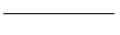
1 TOPOGRAPHY
|
1 |
Contours |
 | |
|
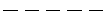
2 |
Approximate contours |
 | |
|
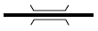
3 |
Relief shown by hachures |
 | |
|
4 |
Bluff, cliff or escarpment |
 | |
|
5 |
Lava flow |
 | |
|
6 |
Sand dunes |
 | |
|
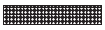
7 |
Sand area |
 | |
|
8 |
Gravel |
 | |
|
9 |
Levee or esker |
 |
 |
 | |||
|
10 |
Unusual land features appropriately labelled |
 | |
 | |||
|
Active volcano |
 | ||
|
11 |
Mountain pass |
 | |
|
12 |
Highest elevation on chart |
|
 |
 | |||
|
13 |
Spot elevation |
 | |
|
14 |
Spot elevation (of doubtful accuracy) |
 | |
|
15 |
Coniferous trees |
 | |
|
16 |
Other trees |
 | |
|
17 |
Palms |
 | |
|
18 |
Areas not surveyed for contour information or relief data incomplete |
 |
2 HYDROGRAPHY
|
19 |
Shore line(reliable) |
 | ||
|
20 |
Shore line(unreliable) |
 | ||
|
21 |
Tidal flats |
 | ||
|
22 |
Coral reefs and ledges |
 | ||
|
23 |
Large river(perennial) |
 | ||
|
24 |
Small river(perennial) |
 | ||
|
25 |
Rivers and streams (non-perennial) |
|
 | |
 | ||||
|
26 |
Rivers and streams (unsurveyed) |
 | ||
|
27 |
Rapids |
 | ||
|
28 |
Falls |
 | ||
|
29 |
Canal |
 | ||
|
30 |
Abandoned canal Note.-Dry canal having landmark value. |
 | ||
|
31 |
Lakes (perennial) |
 | ||
|
32 |
Lakes (non-perennial) |
|
 | |
 | ||||
|
33 |
Salt lake |
 | ||
|
34 |
Salt pans(evaporator) |
 | ||
|
35 |
Swamp |
 | ||
|
36 |
Rice field |
|
 | |
 | ||||
|
37 |
Spring, well or water hole |
perennial |
 | |
|
intermitten |
 | |||
|
38 |
Reservoir |
 | ||
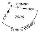
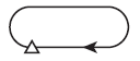
|
39 |
Dry lake bed |
|
 | |
 | ||||
|
40 |
Wash |
|
 | |
 | ||||
|
41 |
Shoals |
 | ||
|
42 |
Glaciers and ice caps |
 | ||
|
43 |
Danger line (2 m or one fathom line) |
 | ||
|
44 |
Charted isolated rock |
 | ||
|
45 |
Rock awash |
 | ||
|
46 |
Unusual water features appropriately labelled |
 | ||
3 Culture
3.1 BUILT-UP AREAS
|
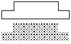
47 |
City or large town |
 |
|
48 |
Town |
 |
|
49 |
Village |
 |
|
50 |
Buildings |
 |
3.2 RAILROADS
|
51 |
Railroad (single track) |
 |
|
52 |
Railroad (two or more tracks) |
 |
|
53 |
Railroad (under construction) |
 |
|
54 |
Railroad bridge |
 |
|
55 |
Railroad tunnel |
 |
|
56 |
Railroad station |
 |
3.3 HIWAYS AND ROADS
|
57 |
Dual highway |
 |
|
58 |
Primary road |
 |
|
59 |
Secondary road |
 |
|
60 |
Trail |
 |
|
61 |
Road bridge |
 |
|
62 |
Road Tunnel |
 |
3.4 MISCELLANEOUS
|
63 |
Boundaries (international) |
 |
|
64 |
Outer boundary |
 |
|
65 |
Fence |
 |
|
66 |
Telegraph or telephone line (when a landmark) |
 |
|
67 |
Dam |
 |
|
68 |
Ferry |
 |
3.5 MISCELLANEOUS (Cont.)
|
69 |
Pipeline |
 |
|
70 |
Oil or gas field |
 |
|
71 |
Tank farms |
 |
|
72 |
Nuclear power station |
 |
|
73 |
Coast guard station |
 |
|
74 |
Lookout tower |
 |
|
75 |
Mine |
 |
|
76 |
Forest ranger station |
 |
|
77 |
Race track stadium |
 |
|
78 |
Ruins |
 |
|
79 |
Fort |
 |
|
80 |
Church |
 |
|
81 |
Mosque |
 |
|
82 |
Pagoda |
 |
|
83 |
Temple |
 |
3.6 AERODROMES
|
84 |
Civil |
Land |
 |
|
85 |
Civil |
Water |
 |
|
86 |
Military |
Land |
 |
|
87 |
Military |
Wate |
 |
|
88 |
Joint Civil and military |
Land |
 |
|
89 |
Joint Civil and military |
Water |
 |
|
90 |
Emergency aerodrome or aerodrome with no facilities |
 | |
|
91 |
Abandoned or closed aerodrome |
 | |
|
92 |
Sheltered anchorage |
 | |
|
93 |
Aerodrome for use on charts on which aerodrome classification is not required e.g. Enroute Charts |
 | |
|
94 |
Heliport Note. Aerodrome for the exclusive use of helicopters |
 | |
|
95 |
Note. Where required by the function of the chart, the runway pattern of the aerodrome may be shown in lieu of the aerodrome symbol, for example: |
 |
4 AERODROMES (Cont.)
4.1 AERODROME DATA IN ABBREVIATED FORM WHICH MAY BE IN ASSOCIATION WITH AERODROME SYMBOLS
|
96 |
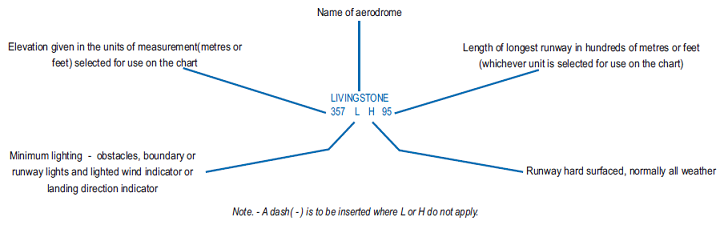 |
4.2 AERODROME SYMBOLS FOR APPROACH CHARTS
|
97 |
Aerodromes affecting the traffic pattern on the aerodrome on which the procedure is based |
 |
|
98 |
The aerodrome on which the procedure is based |
 |
4.3 RADIO NAVIGATION AIDS*
|
99 |
Basic radio navigation aid symbol Note.- This symbol may be used with or without a box to enclose the data. |
 | |
|
100 |
Non-directional radio beacon NDB |
 | |
|
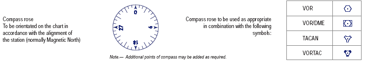
101 |
VHF omnidirectional radio range VOR |
 | |
|
102 |
Distance measuring equipment DME |
 | |
|
103 |
Collocated VOR and DME radio navigation aids VOR/DME |
 | |
|
104 |
DME distance |
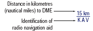 | |
|
105 |
VOR radial |
 | |
|
106 |
UHF tactical air navigation aid TACAN |
 | |
|
107 |
Collocated VOR and TACAN radio navigation aids VORTAC |
 | |
|
108 |
Instrumentlanding system ILS |
 | |
 | |||
 | |||
 | |||
|
109 |
Radio marker beacon |
Elliptical |
 |
|
Bone Shape |
 | ||
|
Note. Marker beacon may be shown by outline, or stipple, or both. | |||
|
110 |
 |
5 AIR TRAFFIC SERVICES
|
111 |
Flight information region FIR |
 | |||
|
112 |
Aerodrome traffic zone ATZ |
 | |||
|
113 |
Control area Airway (CTA) Controlled route (AWY) |
|
 | ||
 | |||||
 | |||||
 | |||||
|
114 |
Uncontrolled route |
 | |||
|
115 |
Advisory airspace ADA |
 | |||
|
116 |
Controled zone CTR |
 | |||
|
117 |
Air defence identification zone ADIZ |
 | |||
|
118 |
Advisory route ADR |
|
 | ||
 | |||||
 | |||||
|
119 |
Visual flight path |
compulsory with radio communication requirement |
 | ||
|
compulsory, without radio communication requirement |
 | ||||
|
requirement recommended |
| ||||
|
120 |
Scale-break (on ATS route) |
|
 | ||
 | |||||
|
significant Point depiction for conventional navigation |
significant Point depiction for area navigation | |||||||
|
121 |
Basic
|
REPORTING
|
On request
|
Compulsory
|
On request
|
Compulsory
|
On request
|
Compulsory
|
|
VFR reporting point |
 |
 |
|
|
 |
 | ||
|
Intersection INT |
 |
 |
|
|
 |
 | ||
|
VORTAC |
|
|
|
|
 |
 | ||
|
TACAN |
 |
 |
|
|
 |
 | ||
|
VOR |
 |
 |
|
|
 |
 | ||
|
VOR/DME |
 |
 |
|
|
 |
 | ||
|
NDB |
 |
 |
|
|
 |
 | ||
|
Waypoint
|
Not Used |
Not Used |
 |
 |
 |
 | ||
|
122 |
Change-over point To be superimposed on the appropriate route symbol at right angles to the route |
COP |
 |
123 |
AIS/MEET reporting point |
MRP |
 |
124 |
Final approach fix |
FAX |
 |
 |
|
125 |
Altitudes/flight levels |
Altitude/flight level "window" |
 |
|
"At or above" altitude/flight level |
 | ||
|
"At or below" altitude/flight level |
 | ||
|
"Mandatory" altitude/flight level |
 | ||
|
"Recommended" procedure altitude/flight level |
 | ||
|
"Expected" altitude |
 | ||
|
Note. For use only on SID and STAR charts. Not intended for depiction of minimum obstacle clearance altitude. | |||
6 AIRSPACE CLASSIFICATIONS
|
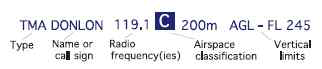
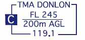
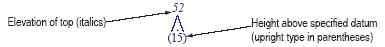
126 |
Airspace classifications |
 |
7 Aeronautical data in abbreviated form to be used in association with airspace classification symbols:
|
81 |
|
 |
 |
8 AIRSPACE RESTRICTIONS
|
128 |
Restricted airspace (prohibited, restricted or danger area) |
 |
Common boundary of two areas |
 |
|
Note. The angle and density of rulings may be varied according to scale and the size, shape and orientation of the area. | ||||
|
129 |
International boundary closed to passage of aircraft except through air corridor |
 | ||
9 OBSTACLES
|
130 |
Obstacle |
 |
|
131 |
Lighted obstacle |
 |
|
132 |
Group obstacles |
 |
|
133 |
Light group obstacles |
 |
|
134 |
Exceptionally high obstacle (optional symbol) |
 |
|
135 |
Exceptionally high obstacle- lighted (optional symbol) Note. For obstacles having a height of the order of 300 m(1 000 ft) above terrain. |
 |
|
136 |
 | |
10 MISCELLANEOUS
|
137 |
Prominent transmission line |
 |
|
138 |
Isogonic line or isogonal |
 |
|
139 |
Ocean station vessel (normal position) |
 |
|
140 |
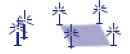
Wind Turbine-unlighted and lighted |
 |
|
141 |
Wind Turbine-Minor group and group in major area, lighted |
 |
11 VISUAL AIDS
|
142 |
Marine light Note 2. Characteristics are to be indicated as follows: |
 |
Note 1. Marine alternating lights are red and white unless otherwise indicated. Marine lights are white unless colours are stated. | ||||
 |
 |
 |
 | ||||
|
143 |
Aeronautical ground light |
 |
 |
144 |
Lightship |
 | |
12 SYMBOLS FOR AERODROME/HELIPORT CHARTS
|
145 |
Hard surface runway |
 | |
|
146 |
Pierced steel plank or steel mesh runway |
 | |
|
147 |
Unpaved runway |
 | |
|
148 |
Stopway SWY |
 | |
|
149 |
Taxiways and parking areas |
 | |
|
150 |
Helicopter alighting area on an aerodrome |
 | |
|
151 |
Aerodrome reference point |
 | |
|
152 |
VOR check-point |
 | |
|
153 |
Runway visual range (RVR) observation site |
 | |
|
154 |
Point light |
 | |
 | |||
|
155 |
Obstacle light |
 | |
|
156 |
Landing direction indicator (lighted) |
 | |
|
157 |
Landing direction indicator (unlighted) |
 | |
|
158 |
Stop bar |
 | |
|
159 |
Runway-holding position |
Pattern A |
 |
|
Pattern B |
 | ||
|
Note. For application, see Annex 14, Volume I, 5.2.10. | |||
|
160 |
Intermediate holding position Note. For application, see Annex 14, Volume I, 5.2.11. |
 | |
|
161 |
Hot spot Note. Hot spot location to be circled. |
 | |
13 SYMBOLS FOR AERODROME OBSTACLE CHARTS - TYPE A, B AND C
|
Plan |
Profile | ||
|
162 |
Tree or shrub |
 |
 |
|
163 |
Pole, tower, spire, antenna, etc. |
 | |
|
164 |
Building or large structure |
 | |
|
165 |
Railroad |
 | |
|
166 |
Transmission line or overhead cable |
 | |
|
167 |
Terrain penetrating obstacle plane |
 |
 |
|
168 |
Escarpment |
 | |
|
169 |
Stopway |
 | |
|
170 |
Clearway |
 | |
14 ADDITIONAL SYMBOLS FOR USE ON PAPER AND ELECTRONIC CHARTS
|
PLAN VIEW |
Electronic | |
|
171 |
Minimum sector altitude MSA Note. This symbol may be modified to reflect particular sector shapes. |
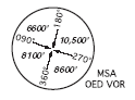 |
|
172 |
Terminal arrival altitude TAA Note. This symbol may be modified to reflect particular TAA shapes. |
 |
|
173 |
Holding pattern |
 |
|
174 |
Missed approach track |
 |
|
PROFILE |
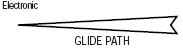
Electronic | |
|
175 |
Runway |
 |
|
176 |
Radio navigation aid (type of aid and its use in the procedure to be annotated on top of the symbol) |
 |
|
177 |
Radio marker beacon (type of beacon to be annotated on top of the symbol) |
 |
|
178 |
Collocated radio navigation aid and marker beacon (type of aid to be annotated on top of the symbol) |
 |
|
179 |
DME fix (distance from DME and the fix use in the procedure to be annotated on top of the symbol) |
 |
|
180 |
Collocated DME fix and marker beacon (distance from DME and the type of beacon to be annotated on top of the symbol) |
 |
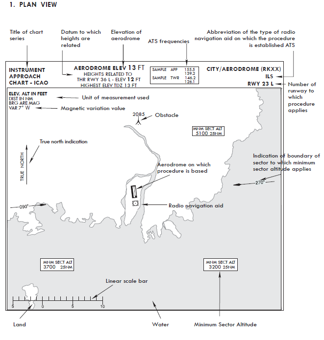
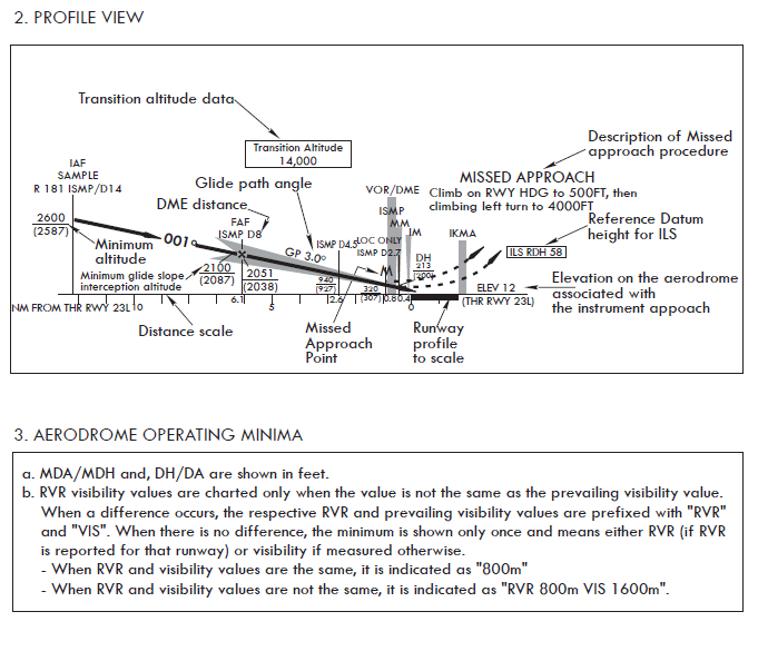
15 INSTRUMENT APPROACH CHART - FORMAT
 |
16 INSTRUMENT APPROACH CHART - FORMAT(Cont)
 |
17 IFR LANDING MINIMA - for FAA format
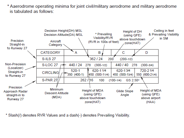 |
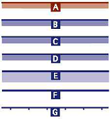
18 Aerodrome Operation Minima CONVERSION CHART
 |
 |
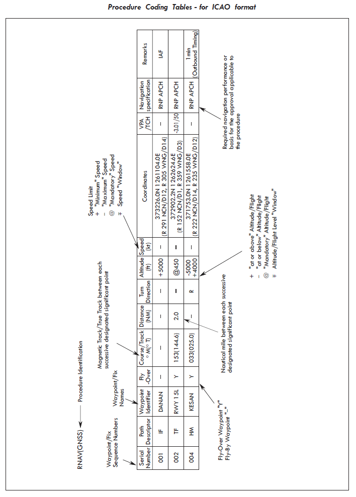
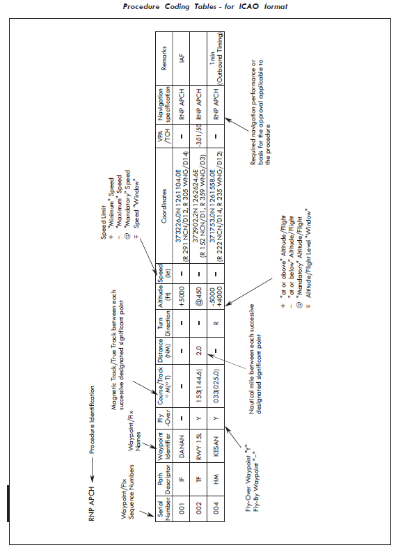
19 Procedure Coding Tables - for ICAO format
  |