RKJJ — Gwangju
RKJJ AD 2.1 AERODROME LOCATION INDICATOR AND NAME
RKNY - YANGYANG / International
RKJJ AD 2.2 AERODROME GEOGRAPHICAL AND ADMINISTRATIVE DATA
|
1 |
ARP coordinates and site at AD |
350735N 1264832E 026° / 1 420 m from THR RWY 04R |
|
2 |
Direction and distance from city |
227°, 5 km from Gwangju City Hall |
|
3 |
Elevation/Reference temperature |
15 m / 31 .8 °C |
|
4 |
Geoid undulation at AD ELEV PSN |
24 m |
|
5 |
Magnetic variation/Annual change |
8° W (201 5 ) / 0.0 67 ° increasing |
|
6 |
Aerodrome Operator, Address, Telephone, Telefax, AFS |
Post:
Gwangju Airport Branch (Busan Regional Office of Avi ation) 420-25, Sangmu-daero, Gwangsan-gu, Gwangju, 506-810, Republic of Korea Tel: Tel: +82-62-942-3737 Fax: Telefax: +82-62-942-5515 AFS: AFS: RKJJYFYX, RKJJZPZX |
|
7 |
Types of traffic permitted(IFR/VFR) |
IFR / VFR |
|
8 |
Remarks |
Military Air Base |
RKJJ AD 2.3 OPERATIONAL HOURS
|
1 |
Aerodrome Operator |
2200-1300 UTC |
|
2 |
Customs and Immigration |
NIL |
|
3 |
Health and Sanitation |
NIL |
|
4 |
AIS Briefing Office |
HO |
|
5 |
ATS Reporting Office(ARO) |
HO |
|
6 |
MET Briefing Office |
H24 |
|
7 |
ATS |
H24 |
|
8 |
Fuelling |
HO |
|
9 |
Handling |
HO |
|
10 |
Security |
HO |
|
11 |
De-icing |
HO |
|
12 |
Remarks |
Civil aircraft operation is restricted from 1300 UTC to 2200 UTC due to aircraft noise around the airport except aircraft in an emergency or in an abnormal situation. |
RKJJ AD 2.4 Handling services and facilities
|
1 |
Cargo-handling facilities |
Up to 64 tons handling possible |
|
2 |
Fuel/oil types |
JP-8 (Available by agreement with ROKAF*) |
|
3 |
Fuelling facilities/capacity |
NIL |
|
4 |
De-icing facilities |
By arrangement with handling agent |
|
5 |
Hangar space for visiting aircraft |
NIL |
|
6 |
Repair facilities for visiting aircraft |
NIL |
|
7 |
Remarks |
* Republic of Korea Air Force(ROKAF) |
RKJJ AD 2.5 PASSENGER FACILITIES
|
1 |
Hotels |
Near AD and in the City |
|
2 |
Restaurants |
At AD and in the City |
|
3 |
Transportation |
Buses, Taxi, Subway and rental cars from AD |
|
4 |
Medical Facilities |
Hospitals in the city |
|
5 |
Bank and Post Office |
Bank available at AD |
|
6 |
Tourist Office |
Available at AD |
|
7 |
Remarks |
http://www.airport.co.kr/mbs/gwangju/ |
RKJJ AD 2.6 RESCUE AND FIRE FIGHTING SERVICES
|
1 |
AD Category for fire fighting |
Available : CAT 8. |
|
2 |
Rescue equipment |
|
|
3 |
Capability for removal of disabled aircraft |
Specialized aircraft recovery equipment available for up to and including B767-300 size aircraft. 470 ton crane and other accessory equipment can be provided by airlines and agencies. Korea Airports Corporation is the co-ordinator for the removal of disabled aircraft and can be reached at Airport Duty Manager. (Tel: +82-62-940-0331, 0352) |
|
4 |
Remarks |
* Aqueous Film Forming Foam(AFFF) |
RKJJ AD 2.7 SEASONAL AVAILABILITY - CLEARING
|
1 |
Type of clearing equipment |
|
|
2 |
Clearance priorities |
|
|
3 |
Remarks |
* Republic of Korea Air Force (ROKAF) ** Korea Airport Cooperation (KAC) |
RKJJ AD 2.8 APRONS, TAXIWAYS AND CHECK LOCATIONS / POSITION DATA
|
1 |
Designation, Apron surface and strength |
|
|
2 |
Designation, Taxiway width, surface and strength |
|
|
3 |
Altimeter check location and elevation |
Apron (Refer to Aircraft Parking/Docking Chart) / 51 FT |
|
4 |
VOR checkpoints |
VOR : NIL |
|
5 |
INS checkpoints |
INS : Every specified aircraft stands (See Aircraft Parking/Docking Chart) |
|
6 |
Remarks |
NIL |
RKJJ AD 2.9 SURFACE MOVEMENT GUIDANCE AND CONTROL SYSTEM AND MARKINGS
|
1 |
Use of aircraft stand ID signs, TWY guide lines and visual docking/parking guidance system of aircraft stands |
|
|
2 |
RWY and TWY markings and LGT |
|
|
3 |
Stop bars |
NIL |
|
4 |
Remarks |
NIL |
RKJJ AD 2.10 AERODROME OBSTACLES
|
In Area 2 | |||||
|
OBST ID/ Designation |
OBST type |
OBST position |
ELEV/HGT 1 473 ft |
Markings/ Type, colour |
Remarks |
|
a |
b |
c |
d |
e |
f |
|
RKJJOB001 |
Hill |
350134.6N 1263954.3E |
1 207 ft |
NIL |
04L/R APCH 22L/R TKOF <caution> - Chimney(352 ft) is located on the left side of final 1.7 NM away from threshold of RWY 22L. - Open drainage is located both side of RWY 04L/22R and right side of RWY 04R/22L ? Obstacles within the area that extends from the edge of the RWY to the 90 m from the RWY centerline - Arresting Gears (BAK-14) on the RWY 04R/22L and RWY 04L/22R |
|
RKJJOB002 |
Hill |
350317.7N 1264150.0E |
NIL | ||
|
RKJJOB003 |
Hill |
350154.3N 1264207.5E |
892 ft |
NIL | |
|
RKJJOB004 |
Hill |
350237.5N 1264223.5E |
866 ft |
NIL | |
|
RKJJOB005 |
Hill |
350541.7N 1264538.5E |
230 ft |
NIL | |
|
RKJJOB006 |
Hill |
350503.4N 1264547.4E |
213 ft |
NIL | |
|
RKJJOB007 |
Hill |
350517.9N 1264658.4E |
177 ft |
NIL | |
|
RKJJOB008 |
Dike |
350641.2N 1264750.3E |
56 ft |
NIL | |
|
RKJJOB009 |
Hill |
350851.7N 1264842.8E |
390 ft |
NIL | |
|
RKJJOB010 |
Hill |
350815.4N 1265001.9E |
358 ft |
NIL | |
|
RKJJOB011 |
Hill |
350650.6N 1265016.1E |
533 ft |
NIL | |
|
RKJJOB012 |
Hill |
350710.1N 1265109.5E |
591 ft |
NIL | |
|
RKJJOB013 |
Hill |
350915.6N 1265657.7E |
1 266 ft |
NIL | |
|
RKJJOB014 |
Hill |
350950.0N 1265816.4E |
1 470 ft |
NIL | |
|
RKJJOB015 |
Mountain |
344944.3N 1264825.1E |
2 012 ft |
NIL | |
|
RKJJOB016 |
Mountain |
350727.4N 1270032.2E |
3 894 ft |
NIL | |
|
RKJJOB017 |
Mountain |
351928.8N 1265308.3E |
2 698 ft |
NIL | |
|
RKJJOB018 |
Mountain |
351800.5N 1265144.8E |
2 388 ft |
NIL | |
|
RKJJOB019 |
Mountain |
352401.0N 1265834.5E |
2 408 ft |
NIL |
22L/R APCH 04L/R TKOF |
|
RKJJOB020 |
Mountain |
352001.8N 1265412.0E |
2 392 ft |
NIL | |
|
RKJJOB021 |
Antenna |
351250.5N 1265007.6E |
541 ft |
Marked/LGTD | |
|
RKJJOB022 |
Antenna |
351143.3N 1264954.4E |
653 ft |
Marked/LGTD | |
|
RKJJOB023 |
Antenna |
351135.5N 1265013.5E |
554 ft |
Marked/LGTD | |
|
RKJJOB024 |
Hill |
351059.7N 1265151.9E |
431 ft |
NIL | |
|
RKJJOB025 |
Hill |
350851.7N 1264842.8E |
390 ft |
NIL |
In RWY 22L/R, 04L/R circling area and at AD |
|
RKJJOB026 |
Hill |
350530.9N 1264920.2E |
554 ft |
NIL | |
|
RKJJOB027 |
Hill |
350650.6N 1265016.1E |
533 ft |
NIL | |
|
RKJJOB028 |
Hill |
350552.7N 1264953.5E |
686 ft |
NIL | |
|
In Area 3 | |||||
|
OBST ID/ Designation |
OBST type |
OBST position |
ELEV/HGT |
Markings/ Type, colour |
Remarks |
|
a |
b |
c |
d |
e |
f |
|
NIL | |||||
RKJJ AD 2.11 METEOROLOGICAL INFORMATION PROVIDED
|
1 |
Associated MET Office |
Gwangju Airforce MET Office |
|
2 |
Hours of service MET Office outside hours |
24 hours - |
|
3 |
Office responsible for TAF preparation Periods of validity |
ROKAF MET Office 30 hours at 0000, 0600, 1200, 1800 UTC |
|
4 |
Trend forecast Interval of issuance |
Trend Type forecast (Gimhae Airport Weather Office) 1 hour (METAR) and when SPECI reported (ROKAF MET Office) |
|
5 |
Briefing/consultation provided |
Available at Gimhae Airport Weather Office for 24 hours, if required |
|
6 |
Flight documentation Language(s) used |
Aerodrome forecasts (TAF code form), SIGWX charts, WINTEM charts, SIGMET information in English |
|
7 |
Charts and other information available for briefing or consultation |
Analysis charts (surface and upper air), Prognostic charts, Graphic displays and other model outputs |
|
8 |
Supplementary equipment available for providing information |
Satellite and weather radar imageries |
|
9 |
ATS units provided with information |
FIC and TWR |
|
10 |
Additional informaton (limitation of service, etc.) |
All observation data, model outputs and forecasts produced by KMA and WAFS are available at the office through Internet link |
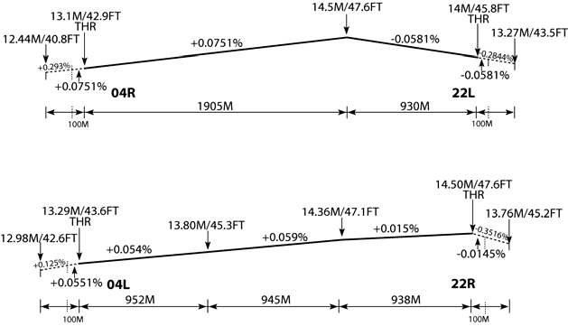
RKJJ AD 2.12 RUNWAY PHYSICAL CHARACTERISTICS
|
Designations Runway NR |
True BRG |
Dimension of RWY(M) |
Strength(PCN) and surface of RWY and SWY |
THR coordinates RWY end coordinates THR geoid undulation |
THR elevation and highest elevation of TDZ of precision APP RWY | ||||||||||||||||||||||||||||||||||||||||
|---|---|---|---|---|---|---|---|---|---|---|---|---|---|---|---|---|---|---|---|---|---|---|---|---|---|---|---|---|---|---|---|---|---|---|---|---|---|---|---|---|---|---|---|---|---|
|
1 |
2 |
3 |
4 |
5 |
6 | ||||||||||||||||||||||||||||||||||||||||
|
04R |
029.93° |
2 835 × 45 |
63/R/B/W/T Concrete |
350653.11N 1264807.47E 24.5 M (80 FT) |
THR 13 .1 M / 4 2.9 FT TDZ 1 3.8 M / 45 .3 FT | ||||||||||||||||||||||||||||||||||||||||
|
22L |
209.93° |
2 835 × 45 |
63/R/B/W/T Concrete |
350812.82N 1264903.32E 24.5 M (80 FT) |
THR 14 M / 46 FT | ||||||||||||||||||||||||||||||||||||||||
|
04L |
029.93° |
2 835 × 45 |
63/R/B/W/T Concrete |
350656.24N 1264800.85E - |
THR 13 M / 44 FT | ||||||||||||||||||||||||||||||||||||||||
|
22R |
209.93° |
2 835 × 45 |
63/R/B/W/T Concrete |
350815.95N 1264856.70E - |
THR 15 M / 48 FT | ||||||||||||||||||||||||||||||||||||||||
|
7. Slope of RWY-SWY | |||||||||||||||||||||||||||||||||||||||||||||
 | |||||||||||||||||||||||||||||||||||||||||||||
RKJJ AD 2.13 DECLARED DISTANCES
|
RWY Designator |
TORA (M) |
TODA (M) |
ASDA (M) |
LDA (M) |
Remarks |
|---|---|---|---|---|---|
|
1 |
2 |
3 |
4 |
5 |
6 |
|
04R |
2 835 |
3 140 |
2 835 |
2 835 |
NIL |
|
22L |
2 835 |
3 140 |
2 835 |
2 835 |
NIL |
|
04L |
2 835 |
3 141 |
2 835 |
2 835 |
NIL |
|
22R |
2 835 |
3 141 |
2 835 |
2 835 |
NIL |
RKJJ AD 2.14 APPROACH AND RUNWAY LIGHTING
|
RWY Designator |
APCH LGT type LEN INTST |
THR LGT Color WBAR |
VASIS (MEHT) PAPI |
TDZ LGT LEN |
RWY Center line LGT Length, Spacing Color, INTST |
RWY edge LGT LEN Spacing Color INTST |
RWY End LGT Color WBAR |
SWY LGT LEN(M) Color |
|---|---|---|---|---|---|---|---|---|
|
1 |
2 |
3 |
4 |
5 |
6 |
7 |
8 |
9 |
|
04R |
ALSF-I 900 M LIH |
Green - |
PAPI Left/3° (52 FT/15.8 M) |
NIL |
NIL |
2 760 M 60M White /Yellow LIH |
Red - |
NIL |
|
22L |
SSALF 420 M LIH |
Green - |
PAPI Both/3° (52 FT/15.8 M) |
NIL |
NIL |
2 760 M 60 M White /Yellow LIH |
Red - |
NIL |
|
04L |
ALSF-I 900 M LIH |
Green Green |
PAPI Both/3° (54 FT/16.5 M) |
NIL |
NIL |
2 760 M 60 M White/Yellow LIH |
Red - |
NIL |
|
22R |
SSALF 420 M LIH |
Green Green |
PAPI Both/3° (54 FT/16.4 M) |
NIL |
NIL |
2 760 M 60 M White/Yellow LIH |
Red - |
NIL |
RKJJ AD 2.15 OTHER LIGHTING, SECONDARY POWER SUPPLY
|
1 |
ABN/IBN location, characteristics and hours of operation |
ABN: At the Water tower Building, FLG W/G EV 10 SEC/IBN: NIL H24 |
|
2 |
LDI location and LGT Anemometer location and LGT |
NIL |
|
3 |
TWY edge and center line lighting |
Edge : All TWY Center line LGT: NIL |
|
4 |
Secondary power supply/swithch-over time |
Secondary power supply to all lighting at AD Switch-over time: 15 SEC |
|
5 |
Remarks |
NIL |
RKJJ AD 2.16 HELICOPTER LANDING AREA
|
1 |
Coordinates TLOF or THR of FATO Geoid undulation |
- |
|
2 |
TLOF and/or FATO elevation M/FT |
- |
|
3 |
TLOF and FATO area dimensions, surface, strength, marking |
- |
|
4 |
True and MAG BRG of FATO |
- |
|
5 |
Declared distance available |
- |
|
6 |
APP and FATO lightng |
- |
|
7 |
Remarks |
As directed by ATC. |
RKJJ AD 2.17 ATS AIRSPACE
|
1 |
Designation and lateral limit |
Gwangju CTR : A circle, radius 5 NM centered at ARP |
|
2 |
Vertical limits |
SFC to 4 000 ft AGL |
|
3 |
Airspace classification |
C |
|
4 |
ATS unit callsign/Languages |
Gwangju Tower / Korean and English |
|
5 |
Transition altitude |
14 000 ft AMSL. |
|
6 |
Operational hours |
H24 |
|
7 |
Remarks |
NIL |
RKJJ AD 2.18 ATS COMMUNICATION FACILITIES
|
Service Designation |
Call sign |
Channel |
Hours of Operation |
Remarks |
|---|---|---|---|---|
|
1 |
2 |
3 |
4 |
5 |
|
APP |
Gwangju Approach |
130.0 MHz, 228.9 MHz, 319.2 MHz |
H24 |
NIL |
|
ARR |
Gwangju Arrival |
132.25M MHz,132.50 MHz 268.0 MHz, 331.4 MHz 379.8 MHz, 366.5 MHz |
H24 |
NIL |
|
DEP |
Gwangju Departure |
124.0 MHz, 347.2 MHz |
H24 |
NIL |
|
TWR |
Gwangju Tower |
118.05 MHz, 236.6 MHz 254.6 MHz |
H24 |
NIL |
|
GND |
Gwangju Ground |
121.8MHz, 275.8 MHz |
H24 |
NIL |
|
ATIS |
Gwangju Airport |
128.875 MHz, 234.700 MHz |
2100 - 1300 (UTC) |
Digital ATIS service available |
|
EMERG |
121.5 MHz, 243.0 MHz |
H24 |
NIL | |
|
Scheduled Inspection Time : - DEP(124.0 MHz), TWR(1 18.05 MHz), GND(1 21.8 MHz), EMERG(121.5 MHz) and ATIS : Every 3rd TUE (1300-1600 UTC) of the month. | ||||
RKJJ AD 2.19 RADIO NAVIGATION AND LANDING AIDS
|
Type of aid MAG VAR Type of supported OPS |
ID |
Frequency |
Hours of Operation |
Position of Transmitting antenna coordinates |
Elevation of DME transmitting antenna |
Remarks |
|---|---|---|---|---|---|---|
|
1 |
2 |
3 |
4 |
5 |
6 |
7 |
|
VOR/DME (8°W/2015) |
KWA |
114.4 MHz (CH91 X ) |
H24 |
350734.2N 1264844.0E |
30 m |
VOR unserviceable
DME unserviceable
SKED Inspection Time : EV 4th TUE(1400-1900UTC) of month. |
|
LOC 04R (8°W/2015) ILS CAT I (8°W or 352°) |
IMDG |
111.1MHz (CH 48X) |
H24 |
350821.5N 1264909.4E |
- |
SKED Inspection Time : EV 2nd TUE(1300-1800UTC) of month. |
|
DME 04R |
IMDG |
1009 MHz (CH48) (TX) 1072 MHz (RX) |
H24 |
350659.3 N 1264817.4 E |
30 m | |
|
GP 04R |
331.7 MHz |
H24 |
350659.3N 1264817.3E |
- |
3°GP RDH 48 ft. | |
|
LOC 22L (8°W/2015) |
IMDH |
108.5 MHz (CH 22X) |
H24 |
350644.3N 1264801.3E |
SKED Inspection Time: EV 1st TUE(1300-1700UTC) of month | |
|
DME 22L |
IMDH |
938
(CH22) (TX) 1046 MHz (RX) |
H24 |
350642.9N 1264804.3E |
30 m |
RKJJ AD 2.20 LOCAL AERODROME REGULATIONS
1 Airport Regulations
-
All aircraft which take-off or landing gross weight is above 146 056 kg can not be operated in accordance with local regulation.
-
Take-off or landing will not be allowed if friction test result is less than the standard as below.
- Standards
· Deceller meter : 6
· SFT : 0.25
-
Civil aircraft shall make touchdown between 500 ft and 2 000 ft from runway threshold except under significant weather conditions or EMERG.
RKJJ AD 2.21 NOISE ABATEMENT PROCEDURES
|
NIL |
RKJJ AD 2.22 FLIGHT PROCEDURES
1 IFR Procedure
- Circling not Authorized in West of the RWY 04R/22L and RWY 04L/22R.
|
CAT |
RWY 04R/L |
RWY 22R |
RWY 22L |
|
A |
Ceiling 200 ft - VIS 800 m |
Ceiling 200 ft - VIS 800 m |
Ceiling 700 ft - VIS 1 200 m |
|
B | |||
|
C |
Ceiling 200 ft - VIS 1 200 m |
Ceiling 700 ft - VIS 2 800 m | |
|
D |
Ceiling 700 ft - VIS 3 200 m |
2 RADAR Procedures
ATC will provide PAR or ASR approach when VOR/DME approach is not usable or efficient.
-
RWY 4R
-
1) Weather minima
CAT
GS/TCH(FT)/RPI(FT)
DA(FT)/VIS(M)
HAT
Ceiling(FT)
A,B,C,D
FULL
3.0° / 48 / 900
245 / 800
200
200
ALS INOP
3.0° / 48 / 900
245 / 1200
200
200
-
2) Missed Approach Procedure : Climb HDG 037 to 800 FT, then climbing right turn HDG 055 maintain 5 000 FT and as directed by GWANGJU APP.
-
-
RWY 4L
-
1) Weather minima
CAT
GS/TCH(FT)/RPI(FT)
DA(FT)/VIS(M)
HAT
Ceiling(FT)
A,B,C,D
FULL
3.0° / 50 / 944
245/ 800
200
200
ALS INOP
3.0° / 50 / 944
245/ 1200
200
200
-
2) Missed Approach Procedure : Climb HDG 037 to 800 FT, then climbing right turn HDG 055 maintain 5 000 FT and as directed by GWANGJU APP.
-
-
RWY 22R
-
1) Weather minima
CAT
GS/TCH(FT)/RPI(FT)
DA(FT)/VIS(M)
HAT
Ceiling(FT)
FULL
A, B
3.0° / 50 / 951
248/ 800
200
200
C, D
3.0° / 50 / 951
248/ 1200
200
200
ALS INOP
A, B, C, D
3.0° / 50 / 951
248/ 1200
200
200
-
2) Missed Approach Procedure : Climb HDG 210 to 5 000 FT, as directed by GWANGJU APP.
-
-
RWY 04R
-
1) Weather minima
CAT
A
B
C
D
E
Straight-in
FULL
560/RVR1220
515(600-3/4)
560/RVR1520
515(600-1)
560/RVR1830
515(600-1 1/4)
ALS INOP
560/RVR1520
515(600-1)
560/1 1/2
515(600-1 1/2)
560/ 1 3/4
515(600-1 3/4)
Circling
860-1
812(900-1)
900-1 1/4
852(900-1 1/4)
940-2 3/4
892(900-2 3/4)
1080-3
1032(1100-3)
1460-3
1412(1500-3)
-
2) Missed Approach Procedure: Climb HDG 037 to 1 200 FT, then climbing right turn HDG 055 maintain 5 000 FT and as directed by GWANGJU APP
-
-
RWY 04L
-
1) Weather minima
CAT
A
B
C
D
E
Straight-in
FULL
560/RVR1220
515(600-3/4)
560/RVR 1520
515(600-1)
560/RVR 1830
515(600-1 1/4)
ALS INOP
560/RVR1520
515(600-1)
560/1 1/2
515(600-1 1/2)
560/1 3/4
515(600-1 3/4)
Circling
860-1
812(900-1)
900-1 1/4
852(900-1 1/4)
940-2 3/4
892(900-2 3/4)
1080-3
1032(1100-3)
1460-3
1412(1500-3)
-
2) Missed Approach Procedure: Climb HDG 037 to 1 200 FT, then climbing right turn HDG 055 maintain 5 000 FT and as directed by GWANGJU APP
-
-
RWY 22L
-
1) Weather minima
CAT
A
B
C
D
E
Straight-in
FULL
860/RVR1220
812(900-3/4)
860/RVR1520
812(900-1)
860/2 1/4
812(900-2 1/4)
860/2 1/2
812(900-2 1/2)
860/2 3/4
812(900-2 3/4)
ALS INOP
860/RVR1520
812(900-1)
860/RVR1830
812(900-1 1/4)
860/2 1/2
812(900-2 1/2)
860/2 3/4
812(900-2 3/4)
860-3
812(900-3)
Circling
860-1
812(900-1)
900-1 1/4
852(900-1 1/4)
940-2 3/4
892(900-2 3/4)
1080-3
1032(1100-3)
1460-3
1412(1500-3)
-
2) Missed Approach Procedure : Climb HDG 210 to 5 000 FT, and as directed by GWANGJU APP.
-
-
RWY 22R
-
1) Weather minima
CAT
A
B
C
D
E
Straight-in
FULL
860/RVR1220
812(900-3/4)
860/RVR1520
812(900-1)
860/2 1/4
812(900-2 1/4)
860/2 1/2
812(900-2 1/2)
860/2 3/4
812(900-2 3/4)
ALS INOP
860/RVR1520
812(900-1)
860/RVR1830
812(900-1 1/4)
860/2 1/2
812(900-2 1/2)
860/2 3/4
812(900-2 3/4)
860-3
812(900-3)
Circling
860-1
812(900-1)
900-1 1/4
852(900-1 1/4)
940-2 3/4
892(900-2 3/4)
1080-3
1032(1100-3)
1460-3
1412(1500-3)
-
2) Missed Approach Procedure : Climb HDG 210 to 5 000 FT, and as directed by GWANGJU APP
-
3 RADIO COMMUNICATION FAILURE PROCEDURE
-
General
-
No person may take off unless two-way radio communications can be maintained with the Air Traffic Control.
-
On recognition of communication failure during flight, squawk 7600 and if necessary to ensure safe altitude, climb to Minimum Safe Altitude or above to maintain obstacle clearance. Then comply with following procedure.
-
-
VFR condition
If the failure to radio communication occurs in VFR conditions, or if VFR conditions are encountered after the failure, a pilot shall continue the flight under VFR and land as soon as practicable based on the runway in use.
-
IFR condition
If the failure occurs in IFR condition, or if the requirements specified in paragraph 2 of this section cannot be met, a pilot shall continue the flight according to the following procedures.
-
DEPARTURE
-
Under Pilot Navigation
- Runway 04R/L in use
-
1) GWANGJU 1A
Climb heading 037° to 2,300ft, thence.......
-
a) LINTA TRANSITION : Left turn intercept KWA VOR R-012 and track outbound. Then join B576 to LINTA. Maintain 8 000 FT
-
b) IPDAS TRANSITION : Right turn direct to KWA R097 10DME at or above 5 000 FT, then right turn heading 225° until join B576 to IPDAS. Maintain 8 000 FT
-
- Runway 22R/L in use
-
2) GWANGJU 2A
Climb heading 217° to 1 900 ft, thence.......
-
a) LINTA TRANSITION : Left turn direct to KWA R097 10 DME (KWJ R-095 10.6 DME) at or above 5 000. then left turn heading 330 until intercept KWA R012(KWJ R-013). then track outbound KWA R-012(KWJ R-013) or join B576, and climb to assigned or specified altitude.
-
b) IPDAS TRANSITION : Left turn intercept KWA VOR R-192 and track outbound KWA VOR R-192 or join B576 to IPDAS Maintain 8 000 FT
-
-
-
Under Radar Vectoring
-
1) Proceed by the direct route from the point of radio failure to the fix, route, or airway specified in the vector clearance;
-
2) In the absence of an assigned route, proceed by the route that ATC will advise through the forthcoming clearance; or
-
3) In the absence of an assigned route or a route that ATC will advise through the forthcoming clearance, proceed by the route filed in the flight plan; and
-
4) Maintain minimum enroute altitude(MEA) or the altitude/flight level cleared in the last ATC clearance received, which ever is higher, for 20 minutes; then
-
5) Continue the flight with altitude/flight level filed in the flight plan
-
-
-
ARRIVAL
- Runway 04R/L in use
The aircraft shall proceed to KOTTY IAF and execute ILS/DME RWY 04R or VOR/DME RWY 04R/L APCH.
- Runway 22R/L in use
The aircraft shall proceed to JADOO IAF and execute VOR/DME RWY 22R/L APCH.
VFR flight which has experienced radio communication failure shall
-
- squawk Mode 3/A code 7600. and
-
- when able to see light gun signal of control tower, follow that instruction
-
- if unable to see light gun signal of control tower, hold on downwind until ETA or for 10 minutes, whichever is linger, then
-
- Aircraft on east pattern should on RWY in use
-
- pilot shall use caution traffic landing and take-off from/to runways.
RKJJ AD 2.23 ADDITIONAL INFORMATION
-
Special VFR not Authorized.
-
Bird concentrates in the vicinity of airport.
The birds' feeding areas consist of surrounding farmland and greens along the river and they frequently move to get their habitat (located QDR 300°, 5 000 M from end of RWY 22R). In the winter, the ducks frequently move at the rise and the set of sun and the lapwings frequently fly before sunset. In the summer, the egrets at the rise of sun and the snipes at the set of sun fly most frequently.
The flying heights are various such as from the ground to 600 M.
The control tower is going to provide the information on the activity of birds and estimated height to the pilots if it is possible. At the same time, the pilots are informed to turn on the landing light in the process of taking off, approach for landing, climbing, and descending as far as the designed limit of aircraft facility allows.
To eliminate the birds, we are using the blank cartridge, signal gun, and loudspeaker. As well, we are operating several equipments including explosive sounds, alarm, sky dancer. For environmental management, we are carrying out various activities simultaneously to prevent the installation of rubbish dump and wastewater treatment plant, and to limit the kinds of trees and the farming in the airport.
-
Use extreme caution, field is surrounded by high angle firing range(RK R14).
